


Woodstock, New York
Woodstock is a community of 2,239 people in Ulster County, New York.
Why visit Woodstock
Townapedia lists 15 museums and landmarks, 9 parks and trails, 29 places to eat, 7 places to stay and 8 attractions in and around town.
Highlights include Colony, Maverick Concerts, Woodstock Artists Association & Museum and Byrdcliffe Colony.
July is the warmest month, with average highs of 80°F; January lows average 12°F, and about 86 inches of snow fall in a normal year.
Weather in Woodstock
Forecast from the National Weather Service. Full forecast
About Woodstock
Woodstock is a hamlet (and census-designated place) in Ulster County, New York, United States. The population was 2,521 according to the 2020 census. The community of Woodstock is in the eastern part of the Town of Woodstock and is northwest of Kingston. It is located along NY 212 near its junction with NY 375.
From the Wikipedia article Woodstock (CDP), New York (this version), under CC BY-SA 4.0.
Things to do8



Reynolds Farm
Farm and orchard · 2.4 mi
Small self-service farmstand with eggs and maple syrup
Museums and landmarks15


Byrdcliffe Colony
Monument and historic site · National Register of Historic Places · 1.3 mi
Arts colony

Judge Jonathan Hasbrouck House
Monument and historic site · National Register of Historic Places
Historic home located at Woodstock, Ulster County, New York

Maverick Concert Hall
Monument and historic site · National Register of Historic Places · 2.0 mi
Concert hall in Hurley, New York, United States
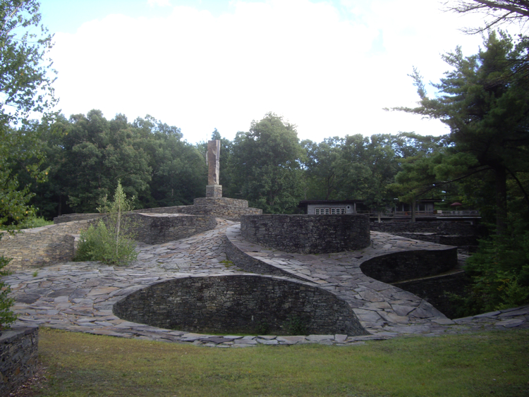
Opus 40
Monument and historic site · National Register of Historic Places · 4.4 mi
Sculpture in Saugerties, New York, United States


National Youth Administration Woodstock Resident Work Center
Monument and historic site · National Register of Historic Places · 1.2 mi
3 more on the map.
Parks, trails and playgrounds9



Restaurants and cafes29

Bread Alone
Cafe · Coffee Shop, Sandwich
22 Mill Hill Road, Woodstock
Mo-Th 07:00-15:00, Fr-Su 07:00-17:00

Catskill Mountain Pizza
Restaurant · Pizza
51 Mill Hill Road, Woodstock
Mo-Th 11:00-21:00; Fr-Sa 11:00-22:00; Su 11:00-21:00

Good Night
Restaurant · Asian
15 Rock City Road, Woodstock
Mo,Th 17:00-21:00; Fr,Sa 17:00-22:00; Su 17:00-21:00
Medo
Restaurant · Japanese · 0.4 mi
83 Mill Hill Road, Woodstock
Tu-Th 17:00-21:00; Fr 17:00-21:30; Sa 10:00-15:00,17:00-21:30; Su...
Nana's Creative Cafe
Cafe · Breakfast, Sandwich, Coffee Shop · 0.4 mi
98 Mill Hill Road, Woodstock
Mo-Fr 08:00-15:00
Pearl Moon
Restaurant · American, Breakfast
52 Mill Hill Road, Woodstock
We-Th 11:00-21:00; Fr-Sa 11:00-23:00+; Su 09:00-16:00
Silvia
Restaurant · American, Eclectic
42 Mill Hill Road, Woodstock
Mo-Th 17:00-21:00, Fr 17:00-22:00, Sa 16:30-22:00, Su 16:30-21:00
The Bear Cantina
Restaurant · Mexican · 2.0 mi
295A Tinker Street, Bearsville
Mo-Th 16:00-21:00, Fr 16:00-21:30, Sa 12:00-21:30, Su 12:00-21:00
The Red Onion
Restaurant · American, Eclectic · 2.5 mi
1654 State Route 212, Saugerties
Mo-Th 17:00-21:00; Fr-Sa 17:00-21:30; Su 17:00-21:00

17 more on the map.
Where to stay7
Churches and places of worship8
Church of the Holy Transfiguration of Christ-on-the-Mount
Church · National Register of Historic Places · 1.9 mi
325 Meads Mountain Road, Woodstock
Shopping27
Gas and EV charging1
Schools, colleges and libraries3
Healthcare3
Map of Woodstock
110 places. The map loads OpenStreetMap tiles when you open it.
Climate by month
Monthly table
| Month | High | Low | Rain | Snow |
|---|---|---|---|---|
| Jan | 32°F | 12°F | 4.9 in | 19.9 in |
| Feb | 35°F | 13°F | 4.0 in | 20.7 in |
| Mar | 42°F | 20°F | 5.7 in | 14.5 in |
| Apr | 55°F | 31°F | 5.2 in | 3.1 in |
| May | 67°F | 42°F | 4.8 in | 0.3 in |
| Jun | 75°F | 51°F | 6.0 in | 0.0 in |
| Jul | 80°F | 55°F | 5.5 in | 0.0 in |
| Aug | 79°F | 54°F | 6.3 in | 0.0 in |
| Sep | 72°F | 48°F | 6.3 in | 0.0 in |
| Oct | 59°F | 37°F | 7.0 in | 1.8 in |
| Nov | 47°F | 28°F | 4.9 in | 4.9 in |
| Dec | 37°F | 19°F | 7.2 in | 20.5 in |
U.S. Climate Normals 1991-2020 for Platte Clove (7 mi away), NOAA NCEI.
People and cost of living
American Community Survey 5-year estimates, 2020-2024, U.S. Census Bureau. Estimates have margins of error, larger for small towns.
Disaster history
Ulster County has had 27 federal disaster declarations since 2000, most often for severe storms.
- 2021-09-05: Remnants Of Hurricane Ida (Hurricane)
- 2021-09-02: Remnants Of Hurricane Ida (Hurricane)
- 2021-08-22: Hurricane Henri (Hurricane)
- 2020-03-20: Covid-19 Pandemic (Biological)
- 2020-03-13: Covid-19 (Biological)
- 2017-07-12: Severe Winter Storm And Snowstorm (Snowstorm)
OpenFEMA disaster declarations summaries.
Getting there and nearby towns
Hudson Valley Regional Airport (POU) is the nearest airport with scheduled flights listed in OpenStreetMap, 31 miles away.
- West Hurley 2 mi south, about 4 min by car
- Ruby 6 mi southeast, about 10 min by car
- Shokan 7 mi southwest, about 11 min by car
- Lake Katrine 8 mi southeast, about 12 min by car
- Lincoln Park 8 mi southeast, about 13 min by car
- Saugerties South 9 mi east, about 14 min by car
- Glasco 9 mi east, about 14 min by car
- Saugerties 9 mi east, about 15 min by car
- Kingston 10 mi southeast, about 16 min by car
- Hurley 10 mi south, about 15 min by car
Drive times are estimates from straight-line distance, not routes.
Local news
Headlines from INDB, the NEMICO news database.
Reviews, tips and questions
Loading what members have shared...
Sources and licences
- NCES EDGE (Public domain): public schools
- NOAA NCEI U.S. Climate Normals 1991-2020 (Public domain): climate by month
- OpenFEMA (Public domain): disaster declarations
- OpenStreetMap contributors (ODbL 1.0): places, airports, map data
- U.S. Census Bureau (Public domain): population, income, housing, education, commute
- Wikidata (CC0 1.0): elevation, founding date, time zone, website, landmarks and historic places
- Wikimedia Commons (see each image): photos
- Wikipedia (CC BY-SA 4.0): overview and history text
Photo credits
- Woodstock Cemetery, NY, on early fall afternoon, Daniel Case, CC BY-SA 4.0
- Overlook Mountain from Woodstock Cemetery in early fall, Daniel Case, CC BY-SA 4.0
- Fifteen Min. of Frame, Woodstock, Beyond My Ken, CC BY-SA 4.0
- Bike-shaped bike rack, Woodstock, Beyond My Ken, CC BY-SA 4.0
- Woodstock Dutch Reformed Church, Thegayfrenchbullie123, CC BY-SA 4.0
- 2-8 Old Forge Road, Woodstock, Beyond My Ken, CC BY-SA 4.0
- Tinker Street, Woodstock, looking SW, Beyond My Ken, CC BY-SA 4.0
- Looking towards Overlook Mountain from Woodstock town center, Thegayfrenchbullie123, CC BY-SA 4.0
- Village Green B&B, 12 Tinker Street, Woodstock, Beyond My Ken, CC BY-SA 4.0
- Woodstock, New York (51172414535), ajay_suresh, CC BY 2.0
- USPS box in Woodstock with stickers (2), Thegayfrenchbullie123, CC BY-SA 4.0
- Dutch Reformed Church, Woodstock, Beyond My Ken, CC BY-SA 4.0
- Candlestock in Woodstock, NY - 55293583400, lostplanetcomics1, CC BY-SA 4.0
- Woodstock lamp post with anti-conservative sticker art, Thegayfrenchbullie123, CC BY-SA 4.0
- Woodstock lamp post with anti-cop and pro-peace sticker art, Thegayfrenchbullie123, CC BY-SA 4.0
- WoodstockNY JudgeJonathanHasbrouckHouse 20170723, Niranjan Arminius, CC BY-SA 4.0
- WoodstockNY JudgeJonathanHasbrouckHouse2 20170723, Niranjan Arminius, CC BY-SA 4.0
- House and thrift shop in Woodstock, New York, PassedDown, CC0
- The Mud Club, Woodstock, NY (51171549398), ajay_suresh, CC BY 2.0
- Woodstock Artists Association & Museum (WAAM) (51171546313), ajay_suresh, CC BY 2.0
- Hexagonal wrap around bench in Woodstock, NY, taking the place of a sidewalk tree that had died, Magpieturtle, CC BY 4.0
- Woodstock Waterfall Park - 55293421249, lostplanetcomics1, CC BY-SA 4.0
- Christ's Lutheran Church Woodstock, NY - 55298115051, lostplanetcomics1, CC BY-SA 4.0
- Woodstock Waterfall Park (51170643667), ajay_suresh, CC BY 2.0
- Woodstock Town Hall (51172414250), ajay_suresh, CC BY 2.0
- Town Hall, Woodstock, Beyond My Ken, CC BY-SA 4.0
- Church-transfiguration-woodstock, Dmadeo, CC BY-SA 3.0
- Maverick Concert Hall in summer, Dion Ogust, GFDL
- Byrdcliffe-theatre-2007, Dmadeo, CC BY-SA 3.0
- Opus-40, Dmadeo, CC BY-SA 3.0
- NYA-WoodstockNY, John E. Leslie III, CC BY-SA 4.0
- Lips 2023, PumpkinMan1943, CC BY-SA 4.0
- Site of NewkirkHouse, HighAtop94, CC BY-SA 4.0
- UCAT Gillig 60, MTATransitFan, CC BY 3.0
- UCAT Gillig 79, MTATransitFan, CC BY 3.0
- Surreal estate (4842782268), lisa cee (Lisa Campeau), CC BY 2.0
- Fake historical marker, Beyond My Ken, CC BY-SA 4.0
- LocalMarket, HighAtop94, CC BY-SA 4.0
- RHassPatriot, HighAtop94, CC BY-SA 4.0
- Looking west from Tinker Street and Tannery Brook Road, PassedDown, CC BY-SA 4.0


Page built October 30, 2026. Spotted a mistake? Tell us or suggest a place.