
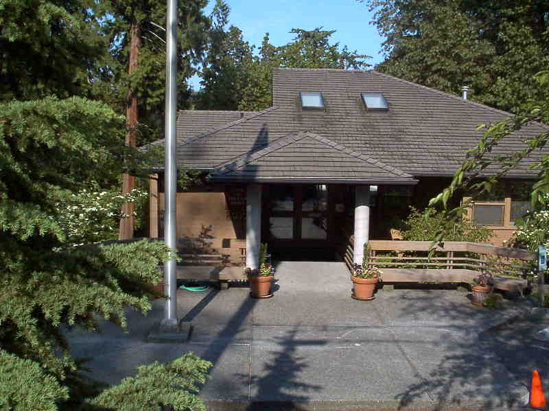


Yarrow Point, Washington
Yarrow Point is a town of 1,198 people in King County, Washington.
Why visit Yarrow Point
Townapedia lists 13 museums and landmarks, 32 parks and trails, 12 places to eat, 1 place to stay and 4 attractions in and around town.
Highlights include Evergreen Point Floating Bridge, Kirkland Performance Center, Dr. Trueblood House and James G. Eddy House and Grounds.
August is the warmest month, with average highs of 77°F; February lows average 37°F.
Weather in Yarrow Point
Forecast from the National Weather Service. Full forecast
About Yarrow Point
Yarrow Point is a town in King County, Washington, United States. The population was 1,134 at the 2020 census.
From the Wikipedia article Yarrow Point, Washington (this version), under CC BY-SA 4.0.
Things to do4

Evergreen Point Floating Bridge
Bridge · 1.8 mi
Floating bridge opened in 2016

Kirkland Performance Center
Cinema and theater · 2.3 mi
Theater in Kirkland, Washington

Northwest University
School · 1.6 mi
Christian liberal arts university in Kirkland, Washington
Washington Technology University
School · 2.6 mi
American private university
Museums and landmarks13

Dr. Trueblood House
Monument and historic site · National Register of Historic Places · 2.6 mi
Private residence in Kirkland, Washington

James G. Eddy House and Grounds
Monument and historic site · National Register of Historic Places · 1.9 mi
Historic house in Medina, Washington state, USA

Joshua Sears Building
Monument and historic site · National Register of Historic Places · 2.6 mi
Building in Washington, United States

Kirkland Woman's Club
Monument and historic site · National Register of Historic Places · 2.4 mi
Historic women's club in Washington

Masonic Lodge Building
Monument and historic site · National Register of Historic Places · 2.6 mi
Listed on the NRHP

Naval Station Puget Sound
Monument and historic site · National Register of Historic Places · 3.1 mi
Former United States Naval station near Seattle, WA

Peter Kirk Building
Monument and historic site · National Register of Historic Places · 2.5 mi
Building in Washington, United States of America

Pioneer Hall
Monument and historic site · National Register of Historic Places · 2.7 mi
Historic building in Seattle, Washington, U.S

Samuel Hyde House
Monument and historic site · National Register of Historic Places · 3.1 mi
Historic house in Seattle, Washington, United States

Swiftsure
Monument and historic site · National Register of Historic Places · 2.2 mi
Lightvessel

Bellevue Arts Museum
Museum · 2.2 mi
Museum in Bellevue, Washington, US

Rosalie Whyel Museum of Doll Art
Museum · 2.0 mi
Bellevue, Washington, United States
1 more on the map.
Parks, trails and playgrounds32

Bellevue Downtown Park
Park · 2.3 mi
Park in Bellevue, Washington, U.S.

Denny-Blaine Park
Park · 3.3 mi
Park in Washington, United States of America




Magnuson Park
Park · 2.8 mi
Park in Washington, United States of America, United States of America

Meydenbauer Bay Park
Park · 2.3 mi
Park in Bellevue, Washington, United States


Northwest Community Center Park
Park · 1.1 mi
9825 Northeast 24th Street, Bellevue
20 more on the map.
Restaurants and cafes12

BeachHouse bar + grill
Diner · American · 1.3 mi
6023 Lake Washington Boulevard Northeast, Kirkland
Mo-Th 11:00-22:00; Fr 11:00-23:00; Sa 09:00-23:00; Su 09:00-22:00

Ivar’s Seafood Bar
Restaurant · Seafood · 1.3 mi
5910 Lake Washington Boulevard Northeast, Kirkland
Mo-Su 11:00-21:00


Burgermaster
Fast food · Burger · 1.0 mi
10606 Northeast Northup Way, Bellevue
Mo-Th,Su 07:00-23:00; Fr-Sa 07:00-24:00
History
Before the arrival of settlers the Duwamish set up two longhouses along Yarrow Bay, although most of the tribe lived in the area occupied by the present day cities of Renton and Seattle. The town was named by newspaper publisher Leigh S. J. Hunt, who lived there from 1886 to 1895, after William Wordsworth's Yarrow poems, which describe the Yarrow Water of Scotland.
From the History section of Yarrow Point, Washington on Wikipedia, under CC BY-SA 4.0.
Where to stay1
Churches and places of worship5
Shopping4
Gas and EV charging4
Schools, colleges and libraries51
Puget Sound Adventist Academy
School · 1.4 mi
5320 108th Avenue Northeast, Kirkland
Healthcare2
Seattle Reproductive Medicine
Clinic and pharmacy · 1.2 mi
3055 112th Avenue Northeast, Bellevue
Map of Yarrow Point
128 places. The map loads OpenStreetMap tiles when you open it.
Climate by month
Monthly table
| Month | High | Low | Rain | Snow |
|---|---|---|---|---|
| Jan | 47°F | 37°F | 5.1 in | 0.9 in |
| Feb | 50°F | 37°F | 3.5 in | 1.0 in |
| Mar | 54°F | 39°F | 3.9 in | 0.0 in |
| Apr | 59°F | 43°F | 3.0 in | 0.0 in |
| May | 65°F | 48°F | 2.2 in | 0.0 in |
| Jun | 70°F | 53°F | 1.6 in | 0.0 in |
| Jul | 76°F | 56°F | 0.8 in | 0.0 in |
| Aug | 77°F | 57°F | 1.0 in | 0.0 in |
| Sep | 71°F | 53°F | 1.7 in | 0.0 in |
| Oct | 60°F | 47°F | 3.6 in | 0.0 in |
| Nov | 52°F | 41°F | 5.8 in | 0.2 in |
| Dec | 46°F | 37°F | 5.5 in | 1.7 in |
U.S. Climate Normals 1991-2020 for Seattle Sand Pt Wsfo (3 mi away), NOAA NCEI.
People and cost of living
American Community Survey 5-year estimates, 2020-2024, U.S. Census Bureau. Estimates have margins of error, larger for small towns.
Disaster history
King County has had 18 federal disaster declarations since 2000, most often for severe storms.
- 2026-04-07: Severe Storms, Straight-Line Winds, Flooding, Landslides, And Mudslides (Flood)
- 2025-12-12: Severe Storms, Straight-Line Winds, Flooding, Landslides, And Mudslides (Flood)
- 2024-04-28: Severe Winter Storms, Straight-Line Winds, Flooding, Landslides, And Mudslides (Severe Storm)
- 2022-09-10: Bolt Creek Fire (Fire)
- 2020-04-23: Severe Storms, Flooding, Landslides, And Mudslides (Flood)
- 2020-03-22: Covid-19 Pandemic (Biological)
OpenFEMA disaster declarations summaries.
Getting there and nearby towns
Kenmore Air Seaplane Terminal (LKE) is the nearest airport with scheduled flights listed in OpenStreetMap, 6 miles away.
- Clyde Hill 1 mi south, about 2 min by car
- Medina 2 mi southwest, about 3 min by car
- Kirkland 4 mi north, about 6 min by car
- Bellevue 4 mi southeast, about 7 min by car
- Redmond 5 mi northeast, about 9 min by car
- Seattle 6 mi west, about 10 min by car
- Mercer Island 6 mi south, about 9 min by car
- Kenmore 7 mi north, about 12 min by car
- Newcastle 8 mi south, about 13 min by car
- Bothell 9 mi north, about 14 min by car
Drive times are estimates from straight-line distance, not routes.
Local news
Headlines from INDB, the NEMICO news database.
Reviews, tips and questions
Loading what members have shared...
Sources and licences
- NCES EDGE (Public domain): public schools
- NOAA NCEI U.S. Climate Normals 1991-2020 (Public domain): climate by month
- OpenFEMA (Public domain): disaster declarations
- OpenStreetMap contributors (ODbL 1.0): places, airports, map data
- U.S. Census Bureau (Public domain): population, income, housing, education, commute
- Wikidata (CC0 1.0): elevation, founding date, time zone, website, landmarks and historic places
- Wikimedia Commons (see each image): photos
- Wikipedia (CC BY-SA 4.0): overview and history text
Photo credits
- Yarrow Point Town Hall, Jplatts at English Wikipedia, Public domain
- 246 at Yarrow Point Freeway Station (18993425054), Atomic Taco from Seattle, WA, USA, CC BY-SA 2.0
- 92nd-Yarrow Point Freeway Station (14669902365), Atomic Taco from Seattle, WA, USA, CC BY-SA 2.0
- 92nd-Yarrow Point Freeway Station and SR-520 (14483266888), Atomic Taco from Seattle, WA, USA, CC BY-SA 2.0
- 92nd-Yarrow Point Freeway Station Elevators Out of Service (14646901236), Atomic Taco from Seattle, WA, USA, CC BY-SA 2.0
- 92nd-Yarrow Point Freeway Station Rider Alert (14483268488), Atomic Taco from Seattle, WA, USA, CC BY-SA 2.0
- 92nd-Yarrow Point Freeway Station Platform (14483268918), Atomic Taco from Seattle, WA, USA, CC BY-SA 2.0
- Seattle - Pioneer Hall 06, Joe Mabel, CC BY-SA 4.0
- Joshua Sears Building 01, Joe Mabel, CC BY-SA 3.0
- Seattle - Samuel Hyde House 04, Joe Mabel, CC BY-SA 3.0
- James G Eddy House (Medina, Washington), Visitor7, CC BY-SA 3.0
- NAS Seattle NAN3-47, USN, Public domain
- Kirkland, WA - 127 7th Avenue 2012, Brianhe, CC BY-SA 3.0
- Swiftsure 01, Joe Mabel, CC BY-SA 3.0
- Kirk Bldg 1889, Publichall, CC BY-SA 3.0
- Kirkland - Campbell Building 01, Joe Mabel, CC BY-SA 3.0
- Kirkland, WA - Kirkland Women's Club 01, Joe Mabel, CC BY-SA 3.0
- Evergreen Point Floating Bridge - looking east from bike trail at west high-rise, SounderBruce, CC BY-SA 4.0
- Whyel Museum of Doll Art Bellevue Washington, Brianhe, CC BY-SA 3.0
- Madison Park - 1, Shakespeare at English Wikipedia, CC BY-SA 3.0
- March 2024 in Seattle, Washington - 11, Another Believer, CC BY-SA 4.0
- Magnuson Park-1, Shakespeare at English Wikipedia, CC BY-SA 3.0
- BellevueArtsMuseum01, Gary Minnaert ( Minnaert )), Public domain
- Denny-Blaine Park-1, Shakespeare at en.wikipedia, CC BY-SA 3.0
- Kirkland Performance Center 02, Joe Mabel, CC BY-SA 3.0
- Aerial Downtown Bellevue Park May 2012, Jelson25, CC BY-SA 3.0
- Viretta Park from above, Joe Mabel, CC BY-SA 3.0
- 20191222 Meydenbauer Bay Park5, Mark Yasuda, CC BY-SA 4.0
- 92nd Ave Transit Station (14483444547), Atomic Taco from Seattle, WA, USA, CC BY-SA 2.0
- Hunts Point, WA - town hall 02, Joe Mabel, CC BY-SA 4.0
- One of several decorative stones marking the City of Clyde Hill, Washington, US, Clyde Charles Brown, CC BY-SA 4.0
- Cross-Kirkland corridor in the fall, Chiwauk, CC BY-SA 4.0
- Bluetooth Special Interest Group 2, Pokechu22, CC BY-SA 4.0
- Evergreen Point Freeway Station (14483240189), Atomic Taco from Seattle, WA, USA, CC BY-SA 2.0
- Evergreen Point Freeway Station Lid Park View (14483437177), Atomic Taco from Seattle, WA, USA, CC BY-SA 2.0
- Evergreen Point Freeway Station Plaza (14689786283), Atomic Taco from Seattle, WA, USA, CC BY-SA 2.0
- Evergreen Point Freeway Station Temporary Platform (14646896326), Atomic Taco from Seattle, WA, USA, CC BY-SA 2.0
- Evergreen Point Freeway Station Platform (14669565032), Atomic Taco from Seattle, WA, USA, CC BY-SA 2.0
- Microsoft Connector at Evergreen Point Freeway Station (14689792893), Atomic Taco from Seattle, WA, USA, CC BY-SA 2.0
- Evergreen Point Freeway Station Lid Park (14669895285), Atomic Taco from Seattle, WA, USA, CC BY-SA 2.0


Page built October 30, 2026. Spotted a mistake? Tell us or suggest a place.