


Yazoo City, Mississippi
Yazoo City is a city of 10,219 people in Yazoo County, Mississippi, founded in 1824.
Why visit Yazoo City
Townapedia lists 5 museums and landmarks, 1 park or trail, 7 places to eat, 3 places to stay and 1 attraction in and around town.
Highlights include Plaza Twin Cinema, Afro-American Sons and Daughters Hospital, Augustus J. Oakes House and Wardell Leak Recreational Complex.
August is the warmest month, with average highs of 95°F; January lows average 39°F.
Weather in Yazoo City
Forecast from the National Weather Service. Full forecast
About Yazoo City
Yazoo City is a city in and the county seat of Yazoo County, Mississippi, United States. It was named after the Yazoo River, which, in turn was named by the French explorer Robert de La Salle in 1682 as "Rivière des Yazous" in reference to the Yazoo tribe living near the river's mouth. Yazoo City is the principal city of the Yazoo City Micropolitan Statistical Area, which is part of the larger Jackson–Yazoo City Combined Statistical Area. As of the 2020 census, Yazoo City had a population of 10,316.
From the Wikipedia article Yazoo City, Mississippi (this version), under CC BY-SA 4.0.
Things to do1

Museums and landmarks5

Afro-American Sons and Daughters Hospital
Monument and historic site · National Register of Historic Places · 0.6 mi
Hospital in Mississippi, United States

Augustus J. Oakes House
Monument and historic site · National Register of Historic Places · 1.3 mi
Historic residence in Yazoo City, Mississippi

Mosely-Woods House
Monument and historic site · National Register of Historic Places · 3.2 mi
House in Yazoo County, Mississippi
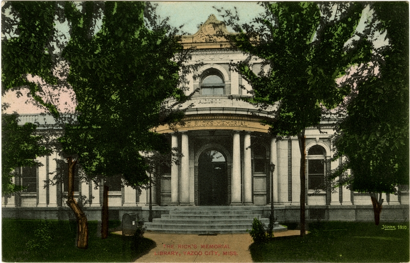


Ricks Memorial Library
Monument and historic site · National Register of Historic Places · 0.9 mi
Library building in Yazoo City, Mississippi

Oakes African American Culture Museum
Museum · 1.3 mi
312 South Monroe Street, Yazoo City
Parks, trails and playgrounds1

Wardell Leak Recreational Complex
Park · 0.6 mi
500 West 15th Street, Yazoo City
24/7
Restaurants and cafes7



History
The community now known as Yazoo City was founded in 1824 with the name Hannan's Bluff. It was later renamed Manchester, then changed to Yazoo City in 1841. Yazoo City became the county seat in 1849. A yellow fever epidemic struck Yazoo City in 1853.
During the American Civil War, the Confederate ironclad CSS Arkansas was completed at a makeshift shipyard in Yazoo City after the Confederate loss of New Orleans and Memphis. During her short career, the Arkansas challenged the Union navy's control of the Mississippi River and helped avert the early fall of Vicksburg. On May 21, 1863, as a Union fleet steamed up the Yazoo River, the Confederate forces burned down the shipyard to keep their foes from capturing the vessels being built there. The Federal forces then burned down the sawmill and lumberyard before withdrawing. After their capture of Vicksburg in July 1863, another Union raid briefly occupied Yazoo City, but this time the Union ironclad USS Baron DeKalb was sunk by a mine. Federal troops occupied the town in September and again in October 1863. Another occupation resulted in the Battle of Yazoo City on March 5, 1864 between the Union troops and Confederates led by Robert V. Richardson and Lawrence Sullivan Ross. The Union troops held their ground but departed the following day. The Federal forces returned again on May 19, 1864, doing more damage to the town.
From the History section of Yazoo City, Mississippi on Wikipedia, under CC BY-SA 4.0.
Where to stay3
Churches and places of worship19
Shopping3
Gas and EV charging7
Schools, colleges and libraries15
Healthcare1
Map of Yazoo City
62 places. The map loads OpenStreetMap tiles when you open it.
Climate by month
Monthly table
| Month | High | Low | Rain | Snow |
|---|---|---|---|---|
| Jan | 58°F | 39°F | 5.7 in | 0.1 in |
| Feb | 63°F | 41°F | 5.6 in | 0.0 in |
| Mar | 71°F | 48°F | 5.9 in | 0.0 in |
| Apr | 79°F | 56°F | 6.6 in | 0.0 in |
| May | 86°F | 65°F | 5.7 in | 0.0 in |
| Jun | 92°F | 72°F | 4.4 in | 0.0 in |
| Jul | 94°F | 75°F | 4.0 in | 0.0 in |
| Aug | 95°F | 74°F | 4.5 in | 0.0 in |
| Sep | 90°F | 68°F | 3.3 in | 0.0 in |
| Oct | 80°F | 57°F | 4.3 in | 0.0 in |
| Nov | 69°F | 46°F | 4.6 in | 0.0 in |
| Dec | 61°F | 41°F | 5.8 in | 0.0 in |
U.S. Climate Normals 1991-2020 for Yazoo City 5 Nne Hcn (3 mi away), NOAA NCEI.
People and cost of living
American Community Survey 5-year estimates, 2020-2024, U.S. Census Bureau. Estimates have margins of error, larger for small towns.
Disaster history
Yazoo County has had 22 federal disaster declarations since 2000, most often for severe storms.
- 2026-02-06: Severe Winter Storm (Winter Storm)
- 2026-01-24: Severe Winter Storm (Winter Storm)
- 2023-08-12: Severe Storms, Straight-Line Winds, And Tornadoes. (Severe Storm)
- 2021-10-22: Hurricane Ida (Hurricane)
- 2021-08-28: Hurricane Ida (Hurricane)
- 2021-05-04: Severe Winter Storms (Severe Ice Storm)
OpenFEMA disaster declarations summaries.
Getting there and nearby towns
Rollang Field (RFK) is the nearest airport with scheduled flights listed in OpenStreetMap, 26 miles away.
- Canton 28 mi southeast, about 46 min by car
- Madison 31 mi southeast, about 50 min by car
- Ridgeland 34 mi southeast, about 54 min by car
- Clinton 35 mi south, about 57 min by car
- Jackson 39 mi south, about 1 h by car
- Flowood 41 mi southeast, about 1 h by car
- Pearl 45 mi southeast, about 1 h 15 min by car
- Vicksburg 46 mi southwest, about 1 h 15 min by car
- Brandon 47 mi southeast, about 1 h 15 min by car
- Greenwood 47 mi north, about 1 h 15 min by car
Drive times are estimates from straight-line distance, not routes.
Local news
Headlines from INDB, the NEMICO news database.
Reviews, tips and questions
Loading what members have shared...
Sources and licences
- NCES EDGE (Public domain): public schools
- NOAA NCEI U.S. Climate Normals 1991-2020 (Public domain): climate by month
- OpenFEMA (Public domain): disaster declarations
- OpenStreetMap contributors (ODbL 1.0): places, airports, map data
- U.S. Census Bureau (Public domain): population, income, housing, education, commute
- Wikidata (CC0 1.0): elevation, founding date, time zone, website, landmarks and historic places
- Wikimedia Commons (see each image): photos
- Wikipedia (CC BY-SA 4.0): overview and history text
Photo credits
- Confederate Memorial in Yazoo City, Mississippi, Kenneth C. Zirkel, CC0
- Confederate Monument, Yazoo City, Mississippi detail, Kenneth C. Zirkel, CC0
- Confederate Monument, Yazoo City, Mississippi, Kenneth C. Zirkel, CC0
- Post Office, Yazoo City, Mississippi, Kenneth C. Zirkel, CC0
- B.S. Ricks Memorial Library, Yazoo City, Mississippi, Kenneth C. Zirkel, CC0
- Marker for Ricks Memorial Library, Yazoo City, Mississippi, Kenneth C. Zirkel, CC0
- Baptist church, Yazoo City, Miss. (8684641376), Mississippi Department of Archives and History, No restrictions
- Yazoo County Court House, Yazoo City, Miss. (8080227550), Mississippi Department of Archives and History, No restrictions
- City hall, Yazoo City, Miss. (8080238442), Mississippi Department of Archives and History, No restrictions
- Baptist church, Yazoo City, Miss. (8683523243), Mississippi Department of Archives and History, No restrictions
- Augustus J. Oakes House (1), Amiratp1, CC BY-SA 4.0
- Ricks Memorial Library Yazoo, Credit: Courtesy of the Mississippi Department of Archives and History, Public domain
- Afro-American Sons and Daughters Hospital, Richard apple, CC BY-SA 3.0
- Tommy McClennan Blues Trail Marker, Chillin662, CC BY-SA 4.0
- ISS015-E-8515 - View of Mississippi, Earth Science and Remote Sensing Unit , Lyndon B. Johnson Space Center, Public domain


Page built October 30, 2026. Spotted a mistake? Tell us or suggest a place.