
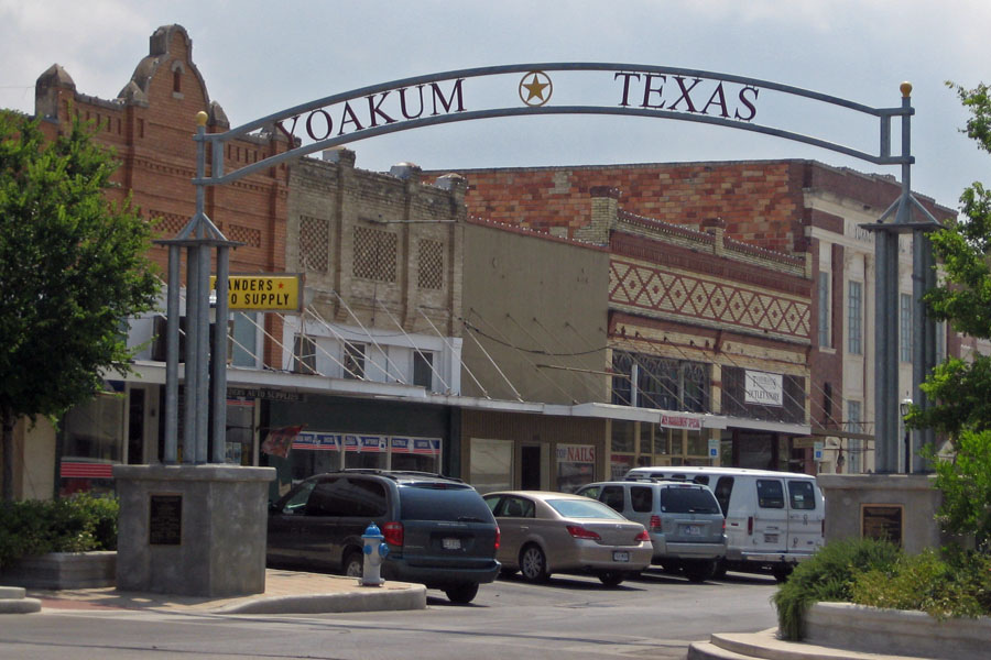

Why visit Yoakum
Townapedia lists 15 museums and landmarks, 3 parks and trails, 1 place to stay and 1 attraction in and around town.
Highlights include Grand Theater, Asberry School and Municipal Golf Course.
August is the warmest month, with average highs of 96°F; January lows average 41°F.
Weather in Yoakum
Forecast from the National Weather Service. Full forecast
About Yoakum
Yoakum is a city in Lavaca and DeWitt counties in the U.S. state of Texas. The population was 5,908 at the 2020 census.
From the Wikipedia article Yoakum, Texas (this version), under CC BY-SA 4.0.
Things to do1

Museums and landmarks15

Hochheim Prairie Farm Mutual Insurance Association
Monument and historic site · 0.9 mi
Katolicka Jednota Zen Texaskych (K.J.Z.T.)_Catholic Women's Union of Texas
Monument and historic site
3 more on the map.
Parks, trails and playgrounds3


Where to stay1

History
The area was sparsely settled until a townsite was laid out with the construction of the San Antonio and Aransas Pass Railway in 1887, and named for Benjamin F. Yoakum, a vice president of the line. The railroad built a roundhouse and maintenance shops there, employing hundreds of workers. The town was incorporated in 1889. According to the Handbook of Texas Online, "By 1896 Yoakum had a cotton mill, three cotton gins, a compress, several churches, a bank, an ice factory, specialty and general stores, two weekly newspapers and one daily, a school system with 700 pupils, and a population of 3,000. By 1914 the number of residents had reached 7,500." In the early 20th century, the Tex-Tan company, later part of the Tandy Corporation, manufactured saddles, bridles, harnesses, belts, and wallets. Other industries included a dairy, a cannery, meat-packing and food-processing plants, and a metalworking shop. Beginning in 1926, tomato farming in the surrounding area became a major agricultural business, with Yoakum being known as "the tomato capital of south central Texas."
From the History section of Yoakum, Texas on Wikipedia, under CC BY-SA 4.0.
Churches and places of worship8
Shopping1
Gas and EV charging1
Schools, colleges and libraries15
Healthcare1
Map of Yoakum
46 places. The map loads OpenStreetMap tiles when you open it.
Climate by month
Monthly table
| Month | High | Low | Rain | Snow |
|---|---|---|---|---|
| Jan | 63°F | 41°F | 2.9 in | 0.0 in |
| Feb | 67°F | 45°F | 1.9 in | 0.0 in |
| Mar | 73°F | 52°F | 3.3 in | 0.0 in |
| Apr | 79°F | 58°F | 3.4 in | 0.0 in |
| May | 86°F | 66°F | 3.8 in | 0.0 in |
| Jun | 91°F | 71°F | 4.4 in | 0.0 in |
| Jul | 94°F | 72°F | 2.8 in | 0.0 in |
| Aug | 96°F | 72°F | 3.5 in | 0.0 in |
| Sep | 90°F | 68°F | 3.8 in | 0.0 in |
| Oct | 83°F | 59°F | 4.4 in | 0.0 in |
| Nov | 73°F | 50°F | 3.1 in | 0.0 in |
| Dec | 65°F | 43°F | 2.7 in | 0.1 in |
U.S. Climate Normals 1991-2020 for Yoakum (1 mi away), NOAA NCEI.
People and cost of living
American Community Survey 5-year estimates, 2020-2024, U.S. Census Bureau. Estimates have margins of error, larger for small towns.
Disaster history
DeWitt County has had 15 federal disaster declarations since 2000, most often for hurricanes.
- 2024-07-09: Hurricane Beryl (Hurricane)
- 2021-02-19: Severe Winter Storms (Severe Ice Storm)
- 2021-02-14: Severe Winter Storm (Severe Ice Storm)
- 2020-03-25: Covid-19 Pandemic (Biological)
- 2020-03-13: Covid-19 (Biological)
- 2017-08-25: Hurricane Harvey (Hurricane)
OpenFEMA disaster declarations summaries.
Getting there and nearby towns
Victoria Regional Airport (VCT) is the nearest airport with scheduled flights listed in OpenStreetMap, 33 miles away.
- Shiner 10 mi north, about 16 min by car
- Cuero 16 mi southwest, about 25 min by car
- Hallettsville 16 mi northeast, about 26 min by car
- Gonzales 24 mi northwest, about 38 min by car
- Flatonia 28 mi north, about 44 min by car
- Schulenburg 30 mi northeast, about 49 min by car
- Yorktown 30 mi southwest, about 49 min by car
- Victoria 34 mi south, about 54 min by car
- Weimar 36 mi northeast, about 58 min by car
- Edna 37 mi southeast, about 1 h by car
Drive times are estimates from straight-line distance, not routes.
Local news
Headlines from INDB, the NEMICO news database.
Reviews, tips and questions
Loading what members have shared...
Sources and licences
- NCES EDGE (Public domain): public schools
- NOAA NCEI U.S. Climate Normals 1991-2020 (Public domain): climate by month
- OpenFEMA (Public domain): disaster declarations
- OpenStreetMap contributors (ODbL 1.0): places, airports, map data
- U.S. Census Bureau (Public domain): population, income, housing, education, commute
- Wikidata (CC0 1.0): elevation, founding date, time zone, website
- Wikimedia Commons (see each image): photos
- Wikipedia (CC BY-SA 4.0): overview and history text
Photo credits
- Yoakum, Texas, Dana Smith, CC BY 2.0
Page built October 30, 2026. Spotted a mistake? Tell us or suggest a place.