


Why visit Aiea
Townapedia lists 16 museums and landmarks, 22 parks and trails, 72 places to eat and 2 attractions in and around town.
Highlights include Admiral Clarey Bridge, Consolidated Theatres Pearlridge, Pacific Fleet Submarine Museum and USS Bowfin.
August is the warmest month, with average highs of 89°F; January lows average 67°F.
Weather in Aiea
Forecast from the National Weather Service. Full forecast
About Aiea
ʻAiea (; Hawaiian: [ʔɐjˈɛjə]) is a census-designated place (CDP) located in the City and County of Honolulu, Hawaii, United States. As of the 2020 Census, the CDP had a total population of 10,408.
From the Wikipedia article ʻAiea, Hawaii (this version), under CC BY-SA 4.0.
Things to do2

Admiral Clarey Bridge
Bridge · 1.7 mi
Bridge connecting Ford Island to mainland Oʻahu on Pearl Harbor in the US state of Hawaii

Museums and landmarks16

Pacific Fleet Submarine Museum
Museum · 1.5 mi
11 Arizona Memorial Drive, Honolulu
Mo-Su 07:00-17:00; Nov Th[4] off; Dec 25 off; Jan 01 off

USS Bowfin
Monument and historic site · National Register of Historic Places · 1.5 mi
1942 Balao-class submarine

Commander in Chief Pacific Fleet Headquarters
Monument and historic site · National Register of Historic Places · 1.7 mi
World war two naval fleet

Naval Station Pearl Harbor
Monument and historic site · National Register of Historic Places · 2.8 mi
Naval base near Honolulu, Hawaii, USA
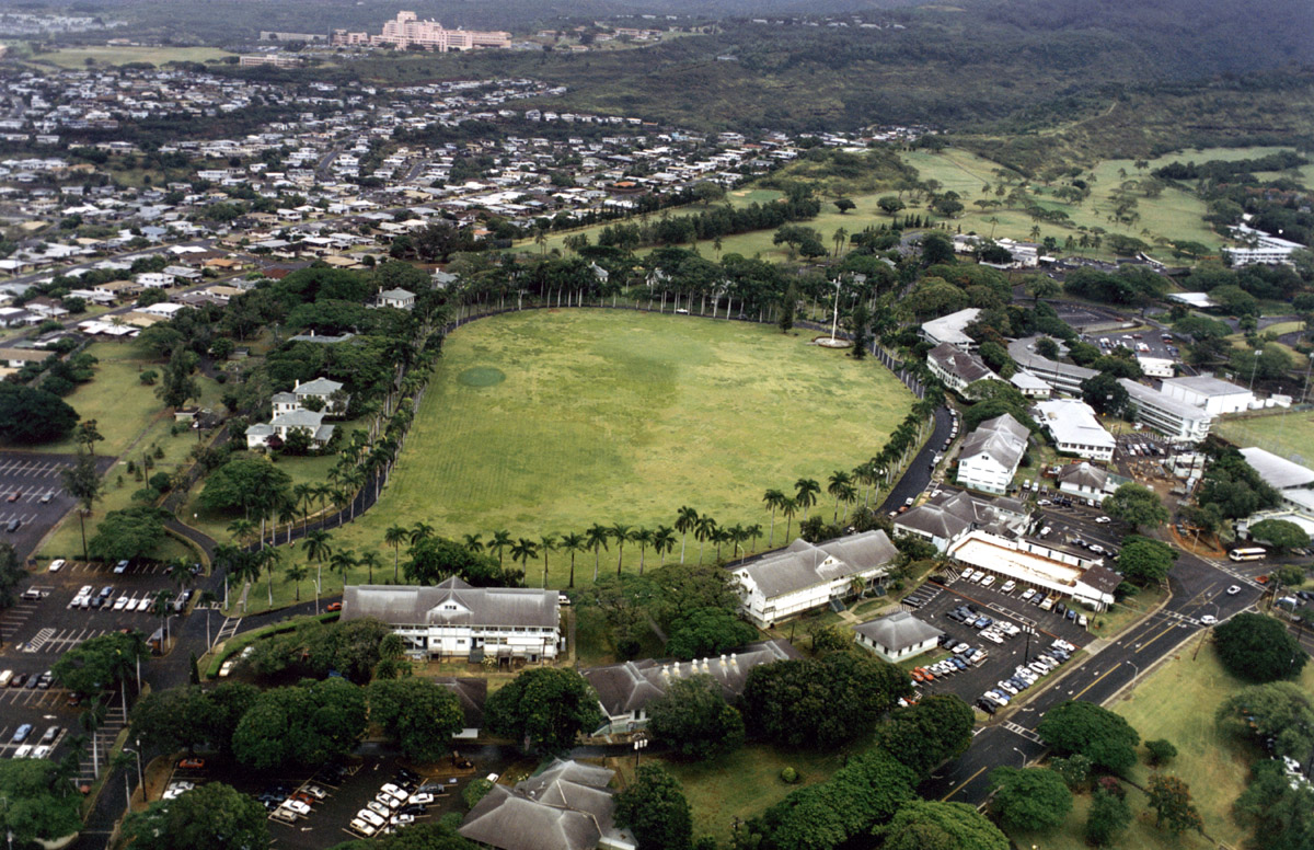
Palm Circle
Monument and historic site · National Register of Historic Places · 3.3 mi
Historic military complex at Fort Shafter, Hawaiʻi, USA

USS Arizona (BB-39)
Monument and historic site · National Register of Historic Places · 2.2 mi
1915 Pennsylvania-class battleship

USS Arizona Memorial
Monument and historic site · National Register of Historic Places · 2.1 mi
Memorial to soldiers killed on the USS Arizona during the attack on Pearl Harbor

USS Missouri
Monument and historic site · National Register of Historic Places · 2.4 mi
1944 Iowa-class battleship

USS Utah
Monument and historic site · National Register of Historic Places · 2.7 mi
1909 Florida-class battleship


Waimalu Shopping Center
Monument and historic site · National Register of Historic Places · 1.6 mi
Shopping mall in Hawaii

4 more on the map.
Parks, trails and playgrounds22


Moanalua Gardens
Park · 3.3 mi
Park in Honolulu, Honolulu County, United States of America

Aloha Stadium
Sports field and stadium · 0.9 mi
99-500 Salt Lake Boulevard, Honolulu


10 more on the map.
Restaurants and cafes72


Anna Miller's
Diner · American · 1.3 mi
98-115 Kaonohi Street, Aiea
Mo-Fr 08:00-15:00; Sa,Su 07:00-15:00
Big City Diner
Diner · American · 0.9 mi
98-211 Pali Momi Street, Aiea
Mo-Th 10:00-20:00; Fr 10:00-21:00; Sa 08:00-21:00; Su 08:00-20:00

Da Seafood Cartel
Restaurant · Seafood, Mexican · 0.8 mi
98-380 Kamehameha Highway, Aiea
Mo-Su 11:00-19:00
Dixie Grill
Restaurant · Southern · 0.8 mi
99-016 Kamehameha Highway, Aiea
Mo-Su 11:00-21:00; Fr,Sa 11:00-22:00
El Mariachi 2
Restaurant · Mexican · 0.6 mi
99-205 Moanalua Road, Aiea
Tu-Th 11:00-19:30; Fr-Su 11:00-20:00
Gen Korean BBQ
Restaurant · Korean, Barbecue · 1.0 mi
98-1005 Moanalua Road, Aiea
Mo-Su 10:00-22:00; Fr,Sa 10:00-23:00
Ichiriki
Restaurant · Japanese · 1.4 mi
98-150 Kaonohi Street, Aiea
Mo-Th 11:00-14:00,16:00-21:30; Fr 11:00-14:00,16:00-22:30; Sa...
Jessica's
Restaurant · American, Filipino · 1.3 mi
98-150 Kaonohi Street, Aiea
Mo-Th 07:00-15:00; Fr-Su 07:00-21:00
60 more on the map.
History
"ʻAiea" was originally the name of an ahupuaʻa, or Hawaiian land division. The name was derived from a species of plant in the nightshade family, Nothocestrum latifolium. It stretched from ʻAiea Bay (part of Pearl Harbor) into the mountains to the north.
At the end of the 19th century, a sugarcane plantation commonly known as ʻAiea Sugar Mill was opened in the district by the Honolulu Sugar Company.
In July 1941, five months before the attack on Pearl Harbor, Commander Thomas C Latimore from USS Dobbin, vanished while walking in the hills above ʻAiea. Despite several major searches and a naval investigation, his disappearance has never been explained. Within the U.S. Navy, many believed he might have been abducted and killed by a local Hawaiian Japanese spy ring because he had either stumbled upon their activities in the hills or had been specifically targeted because of his background in Naval Intelligence.
On December 7, 1941, a large part of the Japanese attack focused on the military installations around the town and the ships moored off shore. For example, one damaged ship, USS Vestal, beached in ʻAiea Bay to prevent sinking. Many people photographed the attack from the hills in ʻAiea. Part of Naval Base Hawaii was built in ʻAiea, including the Aiea Naval Hospital and the Nimitz Bowl.
From the History section of ʻAiea, Hawaii on Wikipedia, under CC BY-SA 4.0.
Churches and places of worship14
Shopping13
Gas and EV charging6
Schools, colleges and libraries43
Admiral Arthur W Radford High School
School · 1.8 mi
4361 Salt Lake Blvd, Honolulu
Healthcare8
Aiea Medical Building
Clinic and pharmacy · 0.5 mi
99-128 Aiea Heights Drive, Aiea
Pali Momi Outpatient Center
Clinic and pharmacy · 0.9 mi
98-1005 Moanalua Road, Aiea
Map of Aiea
196 places. The map loads OpenStreetMap tiles when you open it.
Climate by month
Monthly table
| Month | High | Low | Rain |
|---|---|---|---|
| Jan | 80°F | 67°F | 1.8 in |
| Feb | 80°F | 67°F | 1.9 in |
| Mar | 81°F | 68°F | 2.4 in |
| Apr | 83°F | 70°F | 0.8 in |
| May | 85°F | 72°F | 0.8 in |
| Jun | 87°F | 74°F | 0.5 in |
| Jul | 88°F | 75°F | 0.5 in |
| Aug | 89°F | 76°F | 0.8 in |
| Sep | 88°F | 75°F | 0.9 in |
| Oct | 87°F | 74°F | 1.5 in |
| Nov | 84°F | 72°F | 2.2 in |
| Dec | 82°F | 69°F | 2.2 in |
U.S. Climate Normals 1991-2020 for Honolulu Intl Ap 91182 (4 mi away), NOAA NCEI.
People and cost of living
American Community Survey 5-year estimates, 2020-2024, U.S. Census Bureau. Estimates have margins of error, larger for small towns.
Disaster history
Honolulu County has had 19 federal disaster declarations since 2000, most often for hurricanes.
- 2026-10-07: Hurricane Lala (Hurricane)
- 2026-09-25: Tropical Storm Nolo (Tropical Storm)
- 2026-04-07: Severe Storms, Flooding, Landslides, And Mudslides (Flood)
- 2025-08-19: Kunia Road Fire (Fire)
- 2022-02-15: Severe Storms, Flooding, And Landslides (Severe Storm)
- 2020-07-25: Hurricane Douglas (Hurricane)
OpenFEMA disaster declarations summaries.
Getting there and nearby towns
Daniel K. Inouye International Airport (HNL) is the nearest airport with scheduled flights listed in OpenStreetMap, 4 miles away.
- Waimalu 1 mi northwest, about 1 min by car
- Halawa 1 mi southeast, about 1 min by car
- Pearl City 2 mi northwest, about 4 min by car
- Waipio 5 mi northwest, about 8 min by car
- Waipahu 6 mi west, about 9 min by car
- Urban Honolulu 7 mi southeast, about 10 min by car
- Mililani Town 7 mi northwest, about 12 min by car
- Royal Kunia 7 mi west, about 11 min by car
- Ewa Gentry 7 mi southwest, about 12 min by car
- Ewa Beach 7 mi southwest, about 12 min by car
Drive times are estimates from straight-line distance, not routes.
Local news
Headlines from INDB, the NEMICO news database.
Reviews, tips and questions
Loading what members have shared...
Sources and licences
- NCES EDGE (Public domain): public schools
- NOAA NCEI U.S. Climate Normals 1991-2020 (Public domain): climate by month
- OpenFEMA (Public domain): disaster declarations
- OpenStreetMap contributors (ODbL 1.0): places, airports, map data
- U.S. Census Bureau (Public domain): population, income, housing, education, commute
- Wikidata (CC0 1.0): elevation, founding date, time zone, website, landmarks and historic places
- Wikimedia Commons (see each image): photos
- Wikipedia (CC BY-SA 4.0): overview and history text
Photo credits
- Puliki pl aiea heights view to pearl harbor, Avriette at English Wikipedia, CC BY-SA 3.0
- Aiea Sunset - panoramio, Eric Tessmer, CC BY 3.0
- Aiea banner, Eric Tessmer, CC BY 3.0
- Aiea, Hawaii, 2010, kimubert from Kobe, Japan, CC BY-SA 2.0
- Children visit their pet in quarantine in Aiea, Hawaii, The Eloquent Peasant, CC BY 4.0
- USS Bowmin submarine - full view side, Max Smith, Public domain
- Ford Island aerial photo RIMPAC 1986, PH2 Thompson, USN, Public domain
- USS Arizona Memorial (aerial view), DoD photo by: PH3(AW/SW) JAYME PASTORIC, USN, Public domain
- U.S. Naval Base, Pearl Harbor, Makalapa Support Facilities, Makalapa Administration Area, Pearl Harbor (Honolulu, Hawaii), Unknown author, Public domain
- Waimalu Shopping Center, Silverswordsweets, CC BY-SA 4.0
- USS Arizona-1, Robert Enrique Muller, Public domain
- PalmCircle AerialView, Unknown author, Public domain
- Missouri Modernized, Camera Operator: EM2 KENNETH D. MEHL (Released to Public), Public domain
- USSutah2, Unknown author Unknown author, Public domain
- Edward Hosaka, Waipahuneitibu, CC BY-SA 4.0
- US Navy KitchenAid, Joanna Poe, CC BY-SA 2.0
- Wendy's (39472403982), Mr. Blue MauMau from USA, CC BY 2.0
- Dedication Plaque, USS Arizona Memorial, Pearl Harbor, Honolulu, HI - 52263960608, w_lemay, CC BY-SA 2.0
- USS Arizona from USS Arizona Memorial, Pearl Harbor, Honolulu, HI - 52262978227, w_lemay, CC BY-SA 2.0
- USS Arizona from USS Arizona Memorial, Pearl Harbor, Honolulu, HI - 52264429290, w_lemay, CC BY-SA 2.0
- Hawaii's abandoned Aloha Stadium view from roof, Quintin Soloviev, CC BY 4.0
- Hawaii's abandoned Aloha Stadium view from upper deck, Quintin Soloviev, CC BY 4.0
- Hawaii's abandoned Aloha Stadium view from 50 yard line, Quintin Soloviev, CC BY 4.0
- Aloha Stadium former scoreboard now installed at Clarence T.C. Ching Athletics Complex, Quintin Soloviev, CC BY 4.0
- Aloha Stadium (2854540310), Cliff from Arlington, Virginia, USA, CC BY 2.0
- Aloha Stadium (2854539802), Cliff from Arlington, Virginia, USA, CC BY 2.0
- Aloha Stadium Swap Meet (2853705205), Cliff from Arlington, Virginia, USA, CC BY 2.0
- Aloha Stadium abandoned 2024, Quintin Soloviev, CC BY 4.0
- Pro Bowl - panoramio, Timothy Shields, CC BY 3.0
- Boris Pistorius Samuel Paparo July 2024, McNam, CC BY 4.0
- Pearlridge West 16, Accipitre, CC BY-SA 4.0
- Pearlridge Monorail, Musashi1600, CC BY-SA 3.0
- Red Hill 2022-06-02, Musashi1600, CC BY 4.0
- NAVFAC Hawaii Officer Receives Meritorious Service Medal - Vogel (35732115671), NAVFAC, CC BY 2.0
- Honolulu Skyline train, eli fessler, CC BY-SA 4.0
- Hālawa (Aloha Stadium) Skyline station, eli fessler, CC BY-SA 4.0
- Hālawa (Aloha Stadium) Skyline station entrance, eli fessler, CC BY-SA 4.0
- 2021-10-06 17 13 33 View east along Interstate H-3 (John A. Burns Freeway) at the exit for Interstate H-201 EAST (Honolulu) in Halawa, Oahu, Hawaii, Famartin, CC BY-SA 4.0
- Skyline platform screen doors, eli fessler, CC BY-SA 4.0
- Syzygium cumini 377982402, Damien Wallace, CC BY 4.0


Page built October 30, 2026. Spotted a mistake? Tell us or suggest a place.