
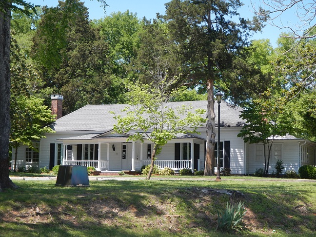

Alexander, Arkansas
Alexander is a city of 3,587 people in Pulaski County, Arkansas, founded in 1887.
Why visit Alexander
Townapedia lists 1 museum or landmark, 1 park or trail and 1 attraction in and around town.
Highlights include Andrew Hunter House.
July is the warmest month, with average highs of 93°F; January lows average 31°F.
Weather in Alexander
Forecast from the National Weather Service. Full forecast
About Alexander
Alexander is a city in Pulaski and Saline counties in the U.S. state of Arkansas. Located in Central Arkansas, the town was founded as a construction camp for the nearby railroad. Following its completion, the citizens decided to incorporate in 1887. Alexander is home to the Arkansas Juvenile Assessment and Treatment Center.
From the Wikipedia article Alexander, Arkansas (this version), under CC BY-SA 4.0.
Things to do1

Museums and landmarks1
Andrew Hunter House
Monument and historic site · National Register of Historic Places · 2.7 mi
Historic house Arkansas Highway 5, a short way east of its junction with Arkansas Highway 183 in Bryant, Arkansas
Parks, trails and playgrounds1

Churches and places of worship1

Gas and EV charging3
Schools, colleges and libraries23
Academies of Math And Sciences School
School · 5.9 mi
6243 Stagecoach Rd, Little Rock
Arkansas Military And First Responders Academy (Amfra)
School · 4.8 mi
10710 Interstate 30, Little Rock
Map of Alexander
30 places. The map loads OpenStreetMap tiles when you open it.
Climate by month
Monthly table
| Month | High | Low | Rain | Snow |
|---|---|---|---|---|
| Jan | 52°F | 31°F | 3.8 in | 0.6 in |
| Feb | 57°F | 34°F | 4.2 in | 0.4 in |
| Mar | 66°F | 41°F | 5.0 in | 0.3 in |
| Apr | 74°F | 50°F | 5.6 in | 0.0 in |
| May | 82°F | 60°F | 5.2 in | 0.0 in |
| Jun | 89°F | 69°F | 3.9 in | 0.0 in |
| Jul | 93°F | 72°F | 4.2 in | 0.0 in |
| Aug | 93°F | 71°F | 3.5 in | 0.0 in |
| Sep | 87°F | 63°F | 3.8 in | 0.0 in |
| Oct | 76°F | 51°F | 4.4 in | 0.0 in |
| Nov | 64°F | 40°F | 4.8 in | 0.0 in |
| Dec | 55°F | 33°F | 4.9 in | 0.0 in |
U.S. Climate Normals 1991-2020 for Benton (9 mi away), NOAA NCEI.
People and cost of living
American Community Survey 5-year estimates, 2020-2024, U.S. Census Bureau. Estimates have margins of error, larger for small towns.
Disaster history
Pulaski County has had 21 federal disaster declarations since 2000, most often for severe storms.
- 2026-01-24: Severe Winter Storm (Winter Storm)
- 2025-05-21: Severe Storms, Tornadoes, And Flooding (Flood)
- 2025-04-05: Severe Storms, Tornadoes, And Flooding (Severe Storm)
- 2023-04-02: Severe Storms And Tornadoes (Severe Storm)
- 2020-08-27: Hurricane Laura (Hurricane)
- 2020-04-03: Covid-19 Pandemic (Biological)
OpenFEMA disaster declarations summaries.
Getting there and nearby towns
Bill and Hillary Clinton National Airport (LIT) is the nearest airport with scheduled flights listed in OpenStreetMap, 15 miles away.
- Bryant 2 mi west, about 4 min by car
- Shannon Hills 3 mi east, about 4 min by car
- Salem 6 mi west, about 10 min by car
- Benton 7 mi west, about 12 min by car
- Landmark 8 mi east, about 12 min by car
- East End 8 mi southeast, about 14 min by car
- Little Rock 9 mi northeast, about 15 min by car
- Haskell 13 mi southwest, about 21 min by car
- Maumelle 16 mi north, about 26 min by car
- North Little Rock 17 mi northeast, about 27 min by car
Drive times are estimates from straight-line distance, not routes.
Local news
Headlines from INDB, the NEMICO news database.
Reviews, tips and questions
Loading what members have shared...
Sources and licences
- NCES EDGE (Public domain): public schools
- NOAA NCEI U.S. Climate Normals 1991-2020 (Public domain): climate by month
- OpenFEMA (Public domain): disaster declarations
- OpenStreetMap contributors (ODbL 1.0): places, airports, map data
- U.S. Census Bureau (Public domain): population, income, housing, education, commute
- Wikidata (CC0 1.0): elevation, founding date, time zone, website, landmarks and historic places
- Wikimedia Commons (see each image): photos
- Wikipedia (CC BY-SA 4.0): overview and history text
Photo credits
- Hunter-Dearborn House, Hwy 5N, Bryant, AR, Marlo B. Krueger, CC BY-SA 3.0
Page built October 30, 2026. Spotted a mistake? Tell us or suggest a place.