


Alliance, Ohio
Alliance is a city of 21,478 people in Mahoning County, Ohio, founded in 1854.
Why visit Alliance
Townapedia lists 5 museums and landmarks, 18 parks and trails, 50 places to eat, 4 places to stay and 4 attractions in and around town.
Highlights include Eagles Building-Strand Theater, Haines House, Alliance Bank Building and Earley's Hill Park.
July is the warmest month, with average highs of 84°F; January lows average 20°F, and about 47 inches of snow fall in a normal year.
Weather in Alliance
Forecast from the National Weather Service. Full forecast
About Alliance
Alliance is a city in Stark County, Ohio, United States. The population was 21,672 at the 2020 census. It was established in 1854 by the merger of three smaller communities and was a manufacturing and railroad hub in the 20th century. Alliance is associated with the state flower of Ohio, the scarlet carnation, and is known as the "Carnation City".
From the Wikipedia article Alliance, Ohio (this version), under CC BY-SA 4.0.
Things to do4

Eagles Building-Strand Theater
Cinema and theater · National Register of Historic Places · 1.1 mi
Commercial building and theater in Alliance, Ohio, United States

Museums and landmarks5

Haines House
Monument and historic site · National Register of Historic Places · 0.8 mi
Historic house in Ohio, United States
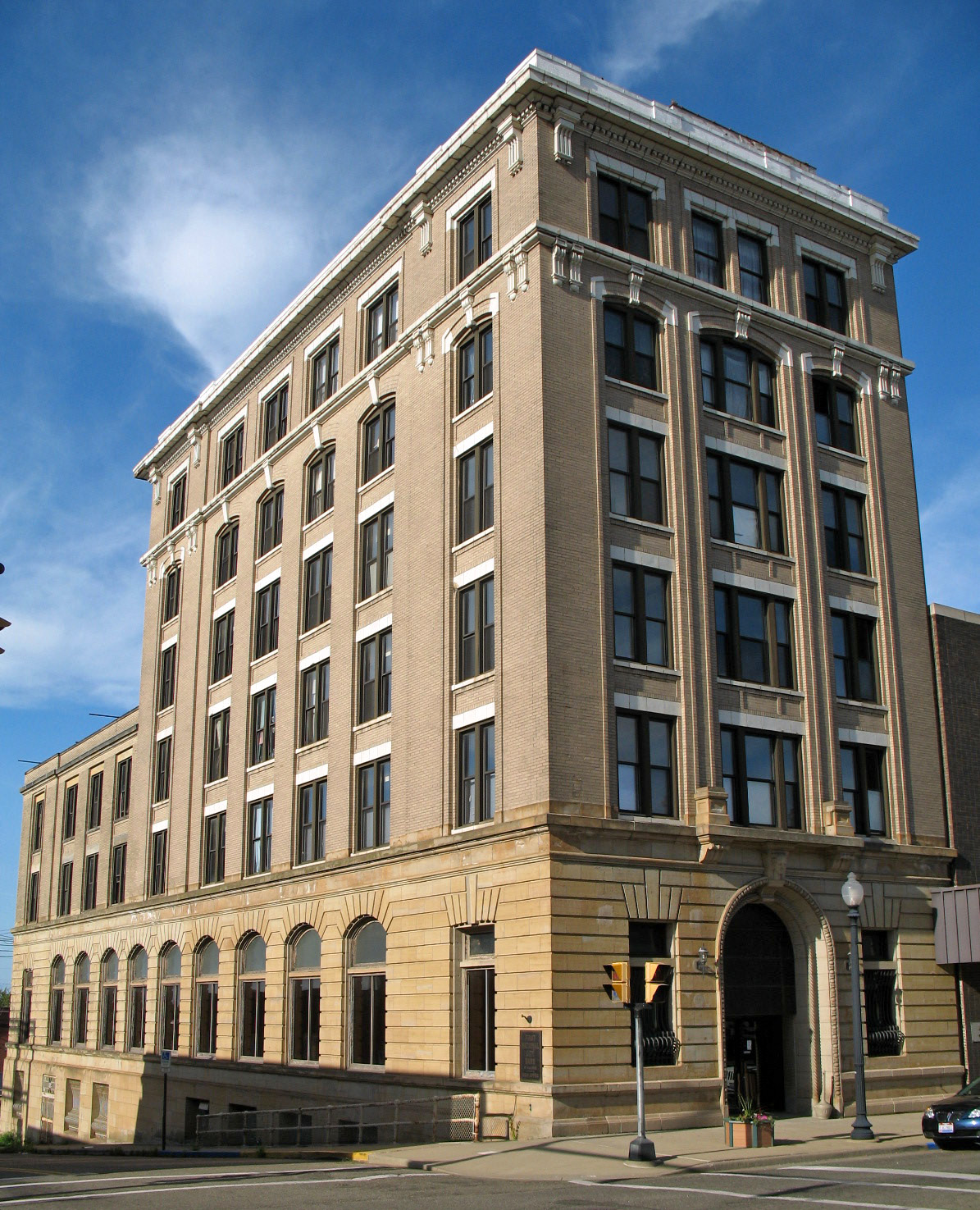
Alliance Bank Building
Monument and historic site · National Register of Historic Places · 1.3 mi
Bank building in Alliance, Ohio


Alliance Clay Product Company
Monument and historic site · National Register of Historic Places · 2.0 mi
Historic district in Alliance, Ohio

Parks, trails and playgrounds18



6 more on the map.
Restaurants and cafes50

Applebee's
Diner · American · 2.1 mi
2600 West State Street, Alliance
Mo-Th 11:00-24:00; Fr-Sa 11:00-01:00; Su 11:00-24:00

Panda Garden
Restaurant · Chinese · 0.9 mi
526 South Union Avenue, Alliance
Mo,We-Th 11:00-21:00; Fr-Sa 11:00-22:00; Su 12:00-21:00
Pizza Hut
Restaurant · Pizza · 1.4 mi
2200 West State Street, Alliance
Su-Th 11:00-23:00; Fr-Sa 11:00-24:00

Almost Heaven Ice Cream
Ice cream · 1.1 mi
2154 Beechwood Avenue, Alliance
Jun-Jul 11:00-20:00; Aug-May 11:00-20:00
Texas Roadhouse
Restaurant · Steak House · 1.2 mi
2033 West State Street, Alliance
Mo-Th 15:00-22:00; Fr,Sa 11:00-23:00; Su 11:00-22:00

38 more on the map.
History
Alliance was founded in 1854 by the merger of three smaller communities called Williamsport, formed in 1827, Freedom, formed in 1838, and Liberty, formed in 1850 to act as a station and support hub for the Cleveland and Pittsburgh Railroad. A fourth community, Mount Union, was added in 1888. Alliance was incorporated as a city in 1889.
There are two popular theories regarding the origin of the city's name. One holds that it was chosen because of the "alliance" of three small settlements into a larger entity. The other theory says the name reflects the fact that two major railroad lines, the Cleveland and Pittsburgh Railroad and the Ohio and Pennsylvania Railroad, intersected at Alliance, once known as "The Crossing".
On April 12, 1856, Alliance was directly struck by a tornado, causing extensive damage. A roof of a church was removed, and another church was moved off its foundation. A train that stopped at the Alliance Station was pushed off its rails. The destruction was estimated to be $15,000 to $20,000 (in 1856 dollars, equivalent to $716,667 in 2025). A few injuries and one fatality were confirmed.
In 1923, Alliance Rubber Company was founded in Alliance. It was a manufacturer of rubber bands cut from discarded rubber rings into small strips.
From the History section of Alliance, Ohio on Wikipedia, under CC BY-SA 4.0.
Where to stay4
Churches and places of worship46
First Methodist Episcopal Church
Church · Methodist · National Register of Historic Places · 1.2 mi
Abiding Savior Lutheran Church
Church · Evangelical Lutheran · 1.0 mi
1845 South Sawburg Road, Alliance
St. Nicholas Romanian Orthodox Church
Church · Romanian Orthodox · 0.9 mi
1621 South Sawburg Road, Alliance
Bolton United Methodist Church
Church · United Methodist · 2.0 mi
14760 Gaskill Drive Northeast
First Christian Church of Alliance
Church · 1.1 mi
114 East Main Street, Alliance
Shopping14
Gas and EV charging11
Schools, colleges and libraries18
Alliance Elementary School At Rockhill
School · 1.0 mi
2400 S Rockhill Ave, Alliance
Alliance Intermediate School @ Northside
School · 1.2 mi
701 Johnson Ave, Alliance
Healthcare7
Akron Children's Hospital Pediatrics - Alliance
Clinic and pharmacy · 1.1 mi
1826 South Arch Avenue, Alliance
Map of Alliance
177 places. The map loads OpenStreetMap tiles when you open it.
Climate by month
Monthly table
| Month | High | Low | Rain | Snow |
|---|---|---|---|---|
| Jan | 36°F | 20°F | 2.9 in | 13.4 in |
| Feb | 39°F | 22°F | 2.4 in | 12.0 in |
| Mar | 48°F | 29°F | 3.2 in | 7.6 in |
| Apr | 62°F | 40°F | 3.9 in | 1.7 in |
| May | 72°F | 50°F | 4.1 in | 0.0 in |
| Jun | 80°F | 59°F | 4.4 in | 0.0 in |
| Jul | 84°F | 63°F | 4.1 in | 0.0 in |
| Aug | 83°F | 62°F | 3.6 in | 0.0 in |
| Sep | 76°F | 55°F | 3.5 in | 0.0 in |
| Oct | 63°F | 44°F | 3.3 in | 0.3 in |
| Nov | 51°F | 34°F | 3.1 in | 3.3 in |
| Dec | 40°F | 26°F | 2.9 in | 8.9 in |
U.S. Climate Normals 1991-2020 for Akron Canton Rgnl Ap 72521 (16 mi away), NOAA NCEI.
People and cost of living
American Community Survey 5-year estimates, 2020-2024, U.S. Census Bureau. Estimates have margins of error, larger for small towns.
Disaster history
Mahoning County has had 9 federal disaster declarations since 2000, most often for severe storms.
- 2020-03-31: Covid-19 Pandemic (Biological)
- 2020-03-13: Covid-19 (Biological)
- 2019-06-18: Severe Storms, Straight-Line Winds, Tornadoes, Flooding, Landslides, And Mudslide (Tornado)
- 2012-06-30: Severe Storms (Severe Storm)
- 2005-09-13: Hurricane Katrina Evacuation (Hurricane)
- 2004-09-19: Severe Storms And Flooding (Severe Storm)
OpenFEMA disaster declarations summaries.
Getting there and nearby towns
Akron-Canton Airport (CAK) is the nearest airport with scheduled flights listed in OpenStreetMap, 17 miles away.
- Salem 14 mi east, about 23 min by car
- Canton 15 mi southwest, about 24 min by car
- North Canton 15 mi west, about 24 min by car
- Ravenna 18 mi north, about 30 min by car
- Green 19 mi west, about 30 min by car
- Kent 21 mi northwest, about 33 min by car
- Tallmadge 21 mi northwest, about 34 min by car
- Massillon 23 mi west, about 37 min by car
- Austintown 23 mi northeast, about 38 min by car
- Akron 24 mi northwest, about 39 min by car
Drive times are estimates from straight-line distance, not routes.
Local news
Headlines from INDB, the NEMICO news database.
Reviews, tips and questions
Loading what members have shared...
Sources and licences
- NCES EDGE (Public domain): public schools
- NOAA NCEI U.S. Climate Normals 1991-2020 (Public domain): climate by month
- OpenFEMA (Public domain): disaster declarations
- OpenStreetMap contributors (ODbL 1.0): places, airports, map data
- U.S. Census Bureau (Public domain): population, income, housing, education, commute
- Wikidata (CC0 1.0): elevation, founding date, time zone, website, landmarks and historic places
- Wikimedia Commons (see each image): photos
- Wikipedia (CC BY-SA 4.0): overview and history text
Photo credits
- Glamorgan Castle (Alliance, OH), Sanfranman59, CC BY-SA 3.0
- Alliance Ohio Pierce Ladder 12 (20432547392), Raymond Wambsgans from Akron Ohio, USA, CC BY-SA 2.0
- Alliance Ohio Pierce Engine 13 (20253216238), Raymond Wambsgans from Akron Ohio, USA, CC BY-SA 2.0
- Alliance Ohio Fire Department Pierce Engine 11 (20414986846), Raymond Wambsgans from Akron Ohio, USA, CC BY-SA 2.0
- Alliance Ohio Fire Department Chevrolet 3500 (19818570484), Raymond Wambsgans from Akron Ohio, USA, CC BY-SA 2.0
- Alliance Ohio Thibault Ladder Tower 14 (19818569434), Raymond Wambsgans from Akron Ohio, USA, CC BY-SA 2.0
- Alliance Ohio Vintage Fire Truck (20414985486), Raymond Wambsgans from Akron Ohio, USA, CC BY-SA 2.0
- Alliance Ohio Fire Department Investigator Ford F-150 (20432549362), Raymond Wambsgans from Akron Ohio, USA, CC BY-SA 2.0
- Chapman Hall, Mount Union College (Alliance, OH), Sanfranman59, CC BY-SA 3.0
- Haines House (Alliance, OH), Sanfranman59, CC BY-SA 3.0
- Greetings from Alliance, Ohio - Large Letter Postcard (5728500464), Steve Shook from Moscow, Idaho, USA, CC BY 2.0
- St. Joseph's Church, Alliance, Nyttend, Public domain
- First Methodist Episcopal Church (Alliance, OH), Sanfranman59, CC BY-SA 3.0
- Alliance city hall, Nyttend, Public domain
- Chapman Hall UMU, Pdcook, CC BY-SA 3.0
- Alliance Bank Building (Alliance, OH), Sanfranman59, CC BY-SA 3.0
- Alliance Clay Product Company complex, Nyttend, Public domain
- Washington Township Fire Department Rescue 4 Ford F-550 (20507147201), Raymond Wambsgans from Akron Ohio, USA, CC BY-SA 2.0
- Lexington Township Fire Department Engine 382 Freightliner FL80 (20462833462), Raymond Wambsgans from Akron Ohio, USA, CC BY-SA 2.0
- Lexington Township Fire Department Rescue 6 Freightliner FL60 (20283524048), Raymond Wambsgans from Akron Ohio, USA, CC BY-SA 2.0
- Lexington Township Fire Department Support Ford F-250 (20477838941), Raymond Wambsgans from Akron Ohio, USA, CC BY-SA 2.0
- Lexington Township Fire Department Tanker 385 Freightliner (20445333786), Raymond Wambsgans from Akron Ohio, USA, CC BY-SA 2.0
- STAT MedEvac EC-135 (20515264902), Raymond Wambsgans from Akron Ohio, USA, CC BY-SA 2.0
- Lexington Township Fire Department Chief Ford F-250 (20471556705), Raymond Wambsgans from Akron Ohio, USA, CC BY-SA 2.0
- Lexington Township Fire Department Rescue 6 Freightliner FL60 (20283451830), Raymond Wambsgans from Akron Ohio, USA, CC BY-SA 2.0
- Lexington Township Fire Department Engine 1 (20462829642), Raymond Wambsgans from Akron Ohio, USA, CC BY-SA 2.0
- Washington Township Fire Department Utility 6 Ford F-250 (19879914673), Raymond Wambsgans from Akron Ohio, USA, CC BY-SA 2.0
- Jackson Township Ohio Police Ford Crown Victoria "Taxi" (20124327234), Raymond Wambsgans from Akron Ohio, USA, CC BY-SA 2.0
- Washington Township Fire Department Rescue 4 Ford F-550 (20314143619), Raymond Wambsgans from Akron Ohio, USA, CC BY-SA 2.0
- Lexington Township Fire Department Support 9 Ford F-350 (20284905249), Raymond Wambsgans from Akron Ohio, USA, CC BY-SA 2.0
- Washington Township Fire Department Brush Rescue Polaris ATV (20500838005), Raymond Wambsgans from Akron Ohio, USA, CC BY-SA 2.0
- Marlboro Vol Fire Department KME Engine 411 (20610136301), Raymond Wambsgans from Akron Ohio, USA, CC BY-SA 2.0
- Marlboro Volunteer Fire Department Midwest Fire Tanker 418 (20416842099), Raymond Wambsgans from Akron Ohio, USA, CC BY-SA 2.0
- Washington Township Fire Department Engine 2 (20507146511), Raymond Wambsgans from Akron Ohio, USA, CC BY-SA 2.0
- Marlboro Volunteer Fire Department Midwest Fire Tanker 418 (20416842499), Raymond Wambsgans from Akron Ohio, USA, CC BY-SA 2.0
- Washington Township Fire Department Engine 2 (20314142979), Raymond Wambsgans from Akron Ohio, USA, CC BY-SA 2.0
- Lexington Township Fire Department Engine 382 Freightliner FL80 (20283454260), Raymond Wambsgans from Akron Ohio, USA, CC BY-SA 2.0
- Lexington Township Fire Department Tanker 385 Freightliner (20477840221), Raymond Wambsgans from Akron Ohio, USA, CC BY-SA 2.0
- Lexington Township Fire Department Tanker 385 Freightliner (20462833042), Raymond Wambsgans from Akron Ohio, USA, CC BY-SA 2.0
- Eagles Building-Strand Theater, Roseohioresident, CC0


Page built October 30, 2026. Spotted a mistake? Tell us or suggest a place.