


Amsterdam, New York
Amsterdam is a city of 18,166 people in Montgomery County, New York, founded in 1710.
Why visit Amsterdam
Townapedia lists 31 museums and landmarks, 17 parks and trails, 39 places to eat, 2 places to stay and 3 attractions in and around town.
Highlights include Mohawk Valley Gateway Overlook pedestrian bridge, Florida Hills, Walter Elwood Museum and Amsterdam Castle.
July is the warmest month, with average highs of 82°F; January lows average 12°F.
Weather in Amsterdam
Forecast from the National Weather Service. Full forecast
About Amsterdam
Amsterdam () is the largest and most populated city in Montgomery County, New York, United States. As of the 2020 census, the city had a population of 18,219. The city is named after Amsterdam in the Netherlands.
From the Wikipedia article Amsterdam, New York (this version), under CC BY-SA 4.0.
Things to do3

Mohawk Valley Gateway Overlook pedestrian bridge
Bridge · 0.5 mi
Pedestrian bridge in Amsterdam, New York


Museums and landmarks31

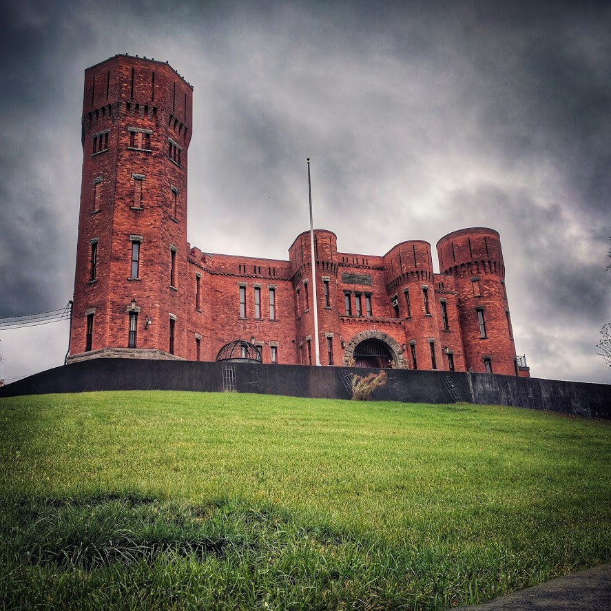
Amsterdam Castle
Monument and historic site · National Register of Historic Places · 0.8 mi
United States historic place in Amsterdam, New York
49 Florida Avenue, Amsterdam

Temple of Israel
Monument and historic site · National Register of Historic Places
Reform synagogue in Amsterdam, New York (state), US

Amsterdam City Hall
Monument and historic site · National Register of Historic Places · 3.6 mi
Town hall in Amsterdam, New York

Chalmers Knitting Mills
Monument and historic site · National Register of Historic Places · 0.5 mi
Historic factory in New York, United States
Gray-Jewett House
Monument and historic site · National Register of Historic Places · 0.7 mi
Historic house in New York, United States
Green Hill Cemetery
Monument and historic site · National Register of Historic Places · 0.4 mi
Cemetery in Amsterdam, New York
Greene Mansion
Monument and historic site · National Register of Historic Places
Historic house in Amsterdam, New York, United States


Guy Park
Monument and historic site · National Register of Historic Places · 1.0 mi
Historic house in New York, United States
Guy Park Avenue School
Monument and historic site · National Register of Historic Places · 1.1 mi
School building in New York, United States of America
Hurricana Stock Farm
Monument and historic site · National Register of Historic Places · 1.2 mi
Historic home and related farm outbuildings located at Amsterdam in Montgomery County, New York
Old Fort Johnson
Monument and historic site · National Register of Historic Places · 2.8 mi
Historic house in the village of Fort Johnson, New York
19 more on the map.
Parks, trails and playgrounds17


Kirk Douglas Park
Park
Named after actor and former resident of Amsterdam, Kirk Douglas. This park is located in the heart of the city and adjacent to the...


5 more on the map.
Restaurants and cafes39



Ruby Tuesday
Diner · American · 1.7 mi
4917 State Highway 30, Amsterdam

Amsterdam Diner
Restaurant · Diner, American, Regional · 2.3 mi
4790 Perth Road, Amsterdam

27 more on the map.
History
Prior to settlement by Europeans, the region which includes Amsterdam was inhabited for centuries by the Mohawk tribe of the Iroquois Confederacy, which dominated most of the Mohawk Valley. They had pushed the Algonquin Mohican tribe to the east of the Hudson River.
Dutch settlers began to arrive in the area in the 1660s, founding Schenectady in 1664. They had previously been based in Albany, along the Hudson River to the east. They reached what would later be Amsterdam c.1710. They called the community "Veeders Mills" and "Veedersburgh" after Albert Veeder, an early mill owner. By the second decade of the 1700s, Scotch-Irish and German Palatinate immigrants began to arrive in the Mohawk Valley region, but few settled in Amsterdam. The governor of the colony granted a group of 100 Palatine German households land in the area that developed as Little Falls to the west, where the English planned they could serve as a buffer to French and Native American incursions.
The American Revolutionary War had little effect on the Amsterdam region. No major battles were fought there or in the surrounding region. The Battle of Johnstown was essentially the repelling of a raid by British forces and their Native American, mostly Iroquois, allies.
From the History section of Amsterdam, New York on Wikipedia, under CC BY-SA 4.0.
Where to stay2
Churches and places of worship23
Saint Joseph-Saint Michael the Archangel-Our Lady of Mount Carmel Catholic Parish
Church · Roman Catholic · 1.0 mi
39 Saint John Street, Amsterdam
Saint Stanislaus Catholic Church
Church · Roman Catholic · 0.6 mi
50 Cornell Street, Amsterdam
Saint Nicholas Ukrainian Catholic Church
Church · Catholic · 0.8 mi
24 Pulaski Street, Amsterdam
Calvary Assembly of God
Place of worship · 0.6 mi
200 East Main Street, Amsterdam
Shopping12
Gas and EV charging9
Schools, colleges and libraries17
Broadalbin-Perth Elementary School
School · 5.3 mi
1870 County Hwy 107, Amsterdam
Marie Curie Institute of Engineering And Communication
School · 1.2 mi
9 Brice St, Amsterdam
Raphael J Mcnulty Academy For Intern Studies & Literacy
School · 0.6 mi
60 Brandt Pl, Amsterdam
St. Mary's Institute
School · Catholic · 1.0 mi
10 Kopernick Boulevard, Amsterdam
Saint Marys Hospital School of Nursing
School · 1.5 mi
380 Guy Park Avenue, Amsterdam
William B. Tecler Arts in Education Magnet School
School · 1.6 mi
210 Northern Boulevard, Amsterdam
William H. Barkley MicroSociety Magnet School
School · 1.0 mi
66 Destefano Avenue, Amsterdam
Healthcare4
Amsterdam Family Practice
Clinic and pharmacy · 2.1 mi
119 Holland Circle Drive, Amsterdam
Map of Amsterdam
157 places. The map loads OpenStreetMap tiles when you open it.
Climate by month
Monthly table
| Month | High | Low | Rain |
|---|---|---|---|
| Jan | 31°F | 12°F | 2.6 in |
| Feb | 34°F | 13°F | 2.4 in |
| Mar | 42°F | 20°F | 3.3 in |
| Apr | 57°F | 33°F | 3.4 in |
| May | 70°F | 44°F | 3.5 in |
| Jun | 77°F | 54°F | 5.0 in |
| Jul | 82°F | 59°F | 4.5 in |
| Aug | 80°F | 56°F | 4.1 in |
| Sep | 74°F | 48°F | 3.6 in |
| Oct | 59°F | 38°F | 4.5 in |
| Nov | 48°F | 28°F | 2.8 in |
| Dec | 36°F | 19°F | 3.0 in |
U.S. Climate Normals 1991-2020 for Delanson 2Ne (12 mi away), NOAA NCEI.
People and cost of living
American Community Survey 5-year estimates, 2020-2024, U.S. Census Bureau. Estimates have margins of error, larger for small towns.
Disaster history
Montgomery County has had 22 federal disaster declarations since 2000, most often for severe storms.
- 2021-08-22: Hurricane Henri (Hurricane)
- 2020-03-20: Covid-19 Pandemic (Biological)
- 2020-03-13: Covid-19 (Biological)
- 2019-12-19: Severe Storms, Straight-Line Winds, And Flooding (Severe Storm)
- 2017-07-12: Severe Winter Storm And Snowstorm (Snowstorm)
- 2013-07-12: Severe Storms And Flooding (Flood)
OpenFEMA disaster declarations summaries.
Getting there and nearby towns
Schenectady County Airport (SCH) is the nearest airport with scheduled flights listed in OpenStreetMap, 14 miles away.
- Hagaman 3 mi northeast, about 4 min by car
- Fort Johnson 3 mi northwest, about 4 min by car
- Tribes Hill 6 mi west, about 9 min by car
- Broadalbin 8 mi north, about 13 min by car
- Mariaville Lake 9 mi south, about 14 min by car
- Fultonville 9 mi west, about 15 min by car
- Fonda 9 mi west, about 15 min by car
- Johnstown 10 mi northwest, about 17 min by car
- Gloversville 11 mi northwest, about 17 min by car
- Albany 28 mi southeast, about 44 min by car
Drive times are estimates from straight-line distance, not routes.
Local news
Headlines from INDB, the NEMICO news database.
Reviews, tips and questions
Loading what members have shared...
Sources and licences
- NCES EDGE (Public domain): public schools
- NOAA NCEI U.S. Climate Normals 1991-2020 (Public domain): climate by month
- OpenFEMA (Public domain): disaster declarations
- OpenStreetMap contributors (ODbL 1.0): places, airports, map data
- U.S. Census Bureau (Public domain): population, income, housing, education, commute
- Wikidata (CC0 1.0): elevation, founding date, time zone, website, landmarks and historic places
- Wikimedia Commons (see each image): photos
- Wikipedia (CC BY-SA 4.0): overview and history text
Photo credits
- Historic Amsterdam NY, Marcbela (Marc N. Belanger), Public domain
- 2020 Greene Mansion, Amsterdam from Greene Street, Beyond My Ken, CC BY-SA 4.0
- 2020 Greene Mansion, Amsterdam from Market Street, Beyond My Ken, CC BY-SA 4.0
- Trinity Lutheran Church rectory, Amsterdam, Beyond My Ken, CC BY-SA 4.0
- Trinity Lutheran Church, Amsterdam, Beyond My Ken, CC BY-SA 4.0
- Former Church of the Evangelical Community, Amsterdam, Beyond My Ken, CC BY-SA 4.0
- Barn on Elizabeth Street, Amsterdam, Beyond My Ken, CC BY-SA 4.0
- St. Joseph's School, Amsterdam, Beyond My Ken, CC BY-SA 4.0
- Sanford Clock Tower, Amsterdam, Beyond My Ken, CC BY-SA 4.0
- Old mills on Prospect Street from west, Amsterdam, Beyond My Ken, CC BY-SA 4.0
- Amsterdam City Hall from north, Beyond My Ken, CC BY-SA 4.0
- Amsterdam City Hall from west 2, Beyond My Ken, CC BY-SA 4.0
- Amsterdam City Hall from front, Beyond My Ken, CC BY-SA 4.0
- Amsterdam City Hall from west 1, Beyond My Ken, CC BY-SA 4.0
- Polish American Veterans, Amsterdam, Beyond My Ken, CC BY-SA 4.0
- St. Ann's Episcopal Church, Amsterdam sanctuary, Beyond My Ken, CC BY-SA 4.0
- St. Ann's Episcopal Church, Amsterdam, Beyond My Ken, CC BY-SA 4.0
- Old mills on Prospect Street from east, Amsterdam, Beyond My Ken, CC BY-SA 4.0
- 47 Church Street, Amsterdam, Beyond My Ken, CC BY-SA 4.0
- 44 Division Street, Amsterdam, Beyond My Ken, CC BY-SA 4.0
- Key Bank Building, Amsterdam, Beyond My Ken, CC BY-SA 4.0
- Amsterdam City Hall side door, Beyond My Ken, CC BY-SA 4.0
- 42 Division Street, Amsterdam, Beyond My Ken, CC BY-SA 4.0
- 40 Division Street, Amsterdam, Beyond My Ken, CC BY-SA 4.0
- 17 Mohawk Place, Amsterdam, Beyond My Ken, CC BY-SA 4.0
- Mohawk Indian Museum, Amsterdam, Beyond My Ken, CC BY-SA 4.0
- Amsterdam Free Library from east, Beyond My Ken, CC BY-SA 4.0
- Amsterdam City Hall outbuilding, Beyond My Ken, CC BY-SA 4.0
- Amsterdam Free Library from south, Beyond My Ken, CC BY-SA 4.0
- Temple of Israel, Amsterdam from front, Beyond My Ken, CC BY-SA 4.0
- Temple of Israel, Amsterdam from south, Beyond My Ken, CC BY-SA 4.0
- 2020 US Post Office, Amsterdam from north, Beyond My Ken, CC BY-SA 4.0
- United Presbyterian Church, Amsterdam, Beyond My Ken, CC BY-SA 4.0
- 2020 US Post Office, Amsterdam from south, Beyond My Ken, CC BY-SA 4.0
- Temple of Israel Amsterdam NY Apr 11, Doug Kerr, CC BY-SA 2.0
- Amsterdam Armory - Stormy, Jess Mann, CC BY-SA 4.0
- Old Guy Park House, Amsterdam, NY, Unknown photographer, Public domain
- Chalmers Knitting Mills Amsterdam NY Jul 09, Doug Kerr, CC BY-SA 2.0
- Saint Stanislaus Roman Catholic Church Amsterdam NY Apr 11, Doug Kerr, CC BY-SA 2.0
- Amsterdam Post Office, Jess Mann, CC BY-SA 4.0


Page built October 30, 2026. Spotted a mistake? Tell us or suggest a place.