


Arden Hills, Minnesota
Arden Hills is a city of 9,658 people in Ramsey County, Minnesota, founded in 1951.
Why visit Arden Hills
Townapedia lists 3 museums and landmarks, 45 parks and trails, 57 places to eat, 5 places to stay and 5 attractions in and around town.
Highlights include Bethel University, Nazareth Hall Preparatory Seminary, Foss House and James J. Hill's North Oaks Farm, Dairy Building.
July is the warmest month, with average highs of 83°F; January lows average 8°F.
Weather in Arden Hills
Forecast from the National Weather Service. Full forecast
About Arden Hills
Arden Hills is a city in Ramsey County, Minnesota, United States. The population was 9,939 at the 2020 census, and was estimated at 9,490 in 2024. Bethel University and its seminary are in the city, and the campus of University of Northwestern – St. Paul straddles the Arden Hills–Roseville border. The city contains the headquarters of Land O'Lakes and Catholic United Financial, a fraternal benefit society.
From the Wikipedia article Arden Hills, Minnesota (this version), under CC BY-SA 4.0.
Things to do5


Nazareth Hall Preparatory Seminary
School · 2.2 mi
High school seminary in Saint Paul, Minnesota
University of Northwestern – St. Paul
School · 2.3 mi
Evangelical Christian college in Minnesota, USA


Museums and landmarks3

Foss House
Monument and historic site · National Register of Historic Places · 3.1 mi
Home in New Brighton, Minnesota, United States
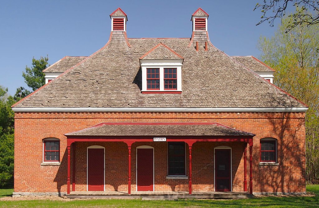


James J. Hill's North Oaks Farm, Dairy Building
Monument and historic site · National Register of Historic Places · 3.2 mi
Building in North Oaks, Minnesota, United States

Parks, trails and playgrounds45

Shamrock Park
Park · 2.7 mi
Park in Shoreview, Minnesota, United States

33 more on the map.
Restaurants and cafes57

Churchill St.
Restaurant · Brunch · 1.3 mi
4606 Churchill Street, Shoreview
Tu-Sa 09:00-20:00; Su 09:00-14:00
Green Mill
Restaurant · Pizza · 1.3 mi
1000 Gramsie Road, Shoreview
Mo-We,Su 11:00-21:00; Th-Sa 11:00-22:00

Limu Coffee
Cafe · 1.7 mi
500 5th Avenue Northwest, New Brighton
Mo-Fr 06:00-16:00; Sa 08:00-15:00; Su 09:00-15:00
Lindey's Prime Steak House
Restaurant · Steak House · 1.4 mi
3600 Snelling Avenue North
Mo-Sa 11:00-22:00
Lisbeth's Cafe & Restaurant
Restaurant · Pakistani, American, Middle Eastern · 2.7 mi
788 Cleveland Avenue Southeast, New Brighton

Big Dipper Creamery
Ice cream · 2.5 mi
115 Village Center Drive, North Oaks
Mo-Sa 11:00-21:00, Su 13:00-21:00
45 more on the map.
Where to stay5
Hilton Garden Inn Minneapolis St. Paul-Shoreview
Motel and hotel · 1.3 mi
1050 Gramsie Road, Shoreview
Quality Inn & Suites Arden Hills - Saint Paul North
Motel and hotel · 1.2 mi
1125 Red Fox Road, Arden Hills
Churches and places of worship10
Ambassador Baptist Church
Church · Baptist · 1.5 mi
3720 Lexington Avenue North, Saint Paul
North Heights Lutheran Church
Church · Lutheran · 0.5 mi
1700 HWY 96W, Arden Hills
Shepherd of the Hills Lutheran Church (ELCA)
Church · Lutheran · 1.9 mi
3920 Victoria Street
Shopping8
Gas and EV charging10
Schools, colleges and libraries56
Healthcare7
HealthPartners Urgent Care Arden Hills
Clinic and pharmacy · 1.1 mi
3930 Northwoods Drive, Arden Hills
Map of Arden Hills
206 places. The map loads OpenStreetMap tiles when you open it.
Climate by month
Monthly table
| Month | High | Low | Rain |
|---|---|---|---|
| Jan | 25°F | 8°F | 0.8 in |
| Feb | 30°F | 11°F | 0.8 in |
| Mar | 42°F | 24°F | 1.5 in |
| Apr | 56°F | 37°F | 3.1 in |
| May | 69°F | 50°F | 4.3 in |
| Jun | 79°F | 60°F | 4.5 in |
| Jul | 83°F | 64°F | 4.5 in |
| Aug | 81°F | 62°F | 4.5 in |
| Sep | 73°F | 54°F | 3.1 in |
| Oct | 59°F | 42°F | 3.1 in |
| Nov | 43°F | 28°F | 1.8 in |
| Dec | 30°F | 16°F | 1.1 in |
U.S. Climate Normals 1991-2020 for Vadnais Lake (4 mi away), NOAA NCEI.
People and cost of living
American Community Survey 5-year estimates, 2020-2024, U.S. Census Bureau. Estimates have margins of error, larger for small towns.
Disaster history
Ramsey County has had 10 federal disaster declarations since 2000, most often for floods.
- 2020-04-07: Covid-19 Pandemic (Biological)
- 2020-03-13: Covid-19 (Biological)
- 2019-06-12: Severe Winter Storm, Straight-Line Winds, And Flooding (Flood)
- 2014-07-21: Severe Storms, Straight-Line Winds, Flooding, Landslides, And Mudslides (Flood)
- 2011-05-10: Severe Storms And Flooding (Flood)
- 2010-04-19: Flooding (Flood)
OpenFEMA disaster declarations summaries.
Getting there and nearby towns
Crystal Airport (MIC) is the nearest airport with scheduled flights listed in OpenStreetMap, 9 miles away.
- Shoreview 1 mi northeast, about 2 min by car
- New Brighton 2 mi west, about 3 min by car
- Mounds View 3 mi northwest, about 5 min by car
- Roseville 4 mi south, about 6 min by car
- Columbia Heights 4 mi west, about 7 min by car
- Fridley 5 mi west, about 8 min by car
- Vadnais Heights 5 mi east, about 8 min by car
- Little Canada 5 mi southeast, about 8 min by car
- Blaine 7 mi north, about 11 min by car
- Lino Lakes 7 mi northeast, about 11 min by car
Drive times are estimates from straight-line distance, not routes.
Local news
Headlines from INDB, the NEMICO news database.
Reviews, tips and questions
Loading what members have shared...
Sources and licences
- NCES EDGE (Public domain): public schools
- NOAA NCEI U.S. Climate Normals 1991-2020 (Public domain): climate by month
- OpenFEMA (Public domain): disaster declarations
- OpenStreetMap contributors (ODbL 1.0): places, airports, map data
- U.S. Census Bureau (Public domain): population, income, housing, education, commute
- Wikidata (CC0 1.0): elevation, founding date, time zone, website, landmarks and historic places
- Wikimedia Commons (see each image): photos
- Wikipedia (CC BY-SA 4.0): overview and history text
Photo credits
- Mounds View High School 01, McGhiever, CC BY-SA 4.0
- Hwy 10 - Arden Hills, MN - panoramio, Gabriel Vanslette, CC BY 3.0
- 35W - Arden Hills, MN - panoramio (2), Gabriel Vanslette, CC BY 3.0
- 35W - Arden Hills, MN - panoramio (3), Gabriel Vanslette, CC BY 3.0
- 35W - Arden Hills, MN - panoramio (4), Gabriel Vanslette, CC BY 3.0
- Interstate 35W - Arden Hills, MN - panoramio (1), Gabriel Vanslette, CC BY 3.0
- 35W - Arden Hills, MN - panoramio (1), Gabriel Vanslette, CC BY 3.0
- Interstate 35W - Arden Hills, MN - panoramio (2), Gabriel Vanslette, CC BY 3.0
- Interstate 35W - Arden Hills, MN - panoramio (4), Gabriel Vanslette, CC BY 3.0
- 35W - Arden Hills, MN - panoramio (5), Gabriel Vanslette, CC BY 3.0
- North Oaks Farm Dairy Building, McGhiever, CC BY-SA 3.0
- Foss House, McGhiever, CC BY-SA 3.0
- BethelWestEnd, Travellers & Tinkers, CC BY-SA 4.0
- Mounds View High School 02, McGhiever, CC BY-SA 4.0
- Interstate 35W - New Brighton, MN - panoramio (5), Gabriel Vanslette, CC BY 3.0
- Interstate 35W - New Brighton, MN - panoramio (7), Gabriel Vanslette, CC BY 3.0
- Interstate 35W - New Brighton, MN - panoramio (8), Gabriel Vanslette, CC BY 3.0
- Interstate 35W - New Brighton, MN - panoramio (9), Gabriel Vanslette, CC BY 3.0
- Interstate 35W - New Brighton, MN - panoramio (10), Gabriel Vanslette, CC BY 3.0
- Interstate 35W - New Brighton, MN - panoramio (12), Gabriel Vanslette, CC BY 3.0
- Interstate 35W - New Brighton, MN - panoramio (6), Gabriel Vanslette, CC BY 3.0
- Shoreview, MN - panoramio (11), Gabriel Vanslette, CC BY 3.0
- Interstate 35W - New Brighton, MN - panoramio (11), Gabriel Vanslette, CC BY 3.0
- Interstate 35W - New Brighton, MN - panoramio (13), Gabriel Vanslette, CC BY 3.0
- KMSP Tower Shoreview, Minnesota, Milonica, CC BY-SA 4.0
- Telefarm and KMSP tower August 2019, Milonica, CC BY-SA 4.0
- Interstate 35W - New Brighton, MN - panoramio (14), Gabriel Vanslette, CC BY 3.0
- 2016-08-05 20 14 38 View south-southeast towards downtown Saint Paul, Ramsey County, Minnesota from a plane departing Minneapolis-Saint Paul International Airport, Famartin, CC BY-SA 4.0
- Perkins - Shoreview MN (7028199923), m01229 from USA, CC BY 2.0
- Interstate 35W - New Brighton, MN - panoramio (16), Gabriel Vanslette, CC BY 3.0
- Interstate 35W - New Brighton, MN - panoramio (19), Gabriel Vanslette, CC BY 3.0
- Interstate 35W - New Brighton, MN - panoramio (15), Gabriel Vanslette, CC BY 3.0
- 1972 Oldsmobile Vista Cruiser (41317422230), Greg Gjerdingen from Willmar, USA, CC BY 2.0
- 1956 Oldsmobile Super 88 Convertible Coupe (42215164655) (cropped), Greg Gjerdingen from Willmar, USA, CC BY 2.0
- 1956 Oldsmobile Super 88 Convertible Coupe (42215164655), Greg Gjerdingen from Willmar, USA, CC BY 2.0
- 1969 Hurst-Olds Vista Cruiser, Shoreview, MN (29256618948), Greg Gjerdingen from Willmar, USA, CC BY 2.0
- 1956 Oldsmobile Super 88 Convertible Coupe (43119745821), Greg Gjerdingen from Willmar, USA, CC BY 2.0
- 1955 Oldsmobile Ninety-Eight Starfire(41308348820), Greg Gjerdingen from Willmar, USA, CC BY 2.0
- 1969 Hurst-Olds Vista Cruiser, Shoreview, MN (29256621398), Greg Gjerdingen from Willmar, USA, CC BY 2.0
- 1969 Hurst-Olds Vista Cruiser, Shoreview, MN (43128851851), Greg Gjerdingen from Willmar, USA, CC BY 2.0


Page built October 30, 2026. Spotted a mistake? Tell us or suggest a place.