


Why visit Lino Lakes
Townapedia lists 2 museums and landmarks, 66 parks and trails, 47 places to eat, 1 place to stay and 2 attractions in and around town.
Highlights include All Good Organics, White Bear Township Theater, E. H. Hobe House-Solheim and James J. Hill's North Oaks Farm, Dairy Building.
July is the warmest month, with average highs of 83°F; January lows average 8°F.
Weather in Lino Lakes
Forecast from the National Weather Service. Full forecast
About Lino Lakes
Lino Lakes is a city in Anoka County, Minnesota, United States. The population was 21,399 at the 2020 census. Interstates 35W and 35E are two of Lino Lakes's main routes. It is an outer suburb north of the Twin Cities.
From the Wikipedia article Lino Lakes, Minnesota (this version), under CC BY-SA 4.0.
Things to do2


Museums and landmarks2

E. H. Hobe House-Solheim
Monument and historic site · National Register of Historic Places · 5.0 mi
Historic house in Minnesota, United States
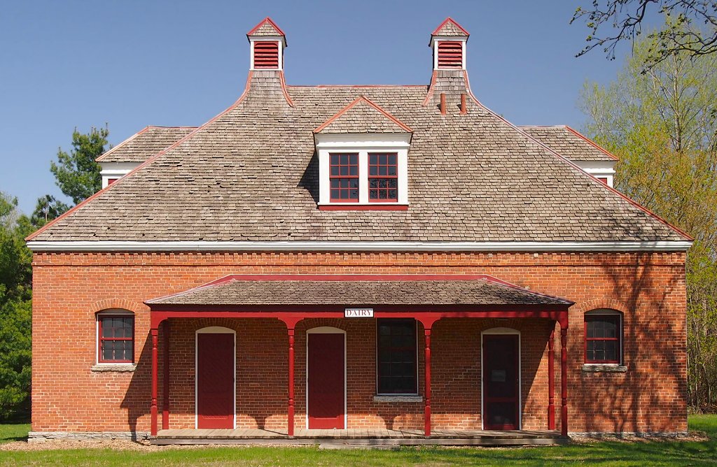


James J. Hill's North Oaks Farm, Dairy Building
Monument and historic site · National Register of Historic Places · 4.8 mi
Building in North Oaks, Minnesota, United States
Parks, trails and playgrounds66

Shamrock Park
Park · 4.9 mi
Park in Shoreview, Minnesota, United States
54 more on the map.
Restaurants and cafes47

Carbone's Pizzeria
Restaurant · Pizza · 3.6 mi
9200 Lexington Avenue North, Lexington
Mo-Th 12:00-21:00; Fr 12:00-22:00; Sa 11:00-22:00; Su 11:00-21:00

Pancho’s Taqueria and Mexican Cafe
Restaurant · Mexican · 3.7 mi
4115 Woodland Road, Circle Pines
Mo-Sa 08:00-21:00; Su 08:00-20:00
Powl Superfood
Restaurant · Smoothie, Juice, American, Açaí, Lunch · 4.2 mi
5932 Lexington Avenue North, Shoreview
Mo-Su 10:00-20:00
35 more on the map.
History
When European settlers arrived, Native Americans already lived in and around the cluster of lakes that are now called Baldwin, Rice, Reshanau, Marshan, George Watch, Centerville, Peltier, and Rondeau. The Dakota people found this to be a land of plenty, with abundant wild rice and small game. Several Native American burial grounds are in the area. European settlers began coming to the area from both Canada and the eastern states around 1850. Those who settled on the lake's west side had names like Ramsden, Speiser, and Wenzel. The east side was settled by families including the Cardinals, LaMottes, Houles and Dupres. Many of their descendants still live in the area.
Several names were suggested for the new village, most containing the word "lakes". The origin of the word "Lino" is unknown. A Lino post office operated for about 10 years in the late 1800s. The town board decided to name the new village Lino Lakes. On May 11, 1955, the Village of Lino Lakes was incorporated. It covered the original Centerville Township except the Village of Centerville, and comprised 21,000 acres of land and 1,800 citizens. In 1972, the state legislature changed all Minnesota villages to cities.
From the History section of Lino Lakes, Minnesota on Wikipedia, under CC BY-SA 4.0.
Where to stay1
Churches and places of worship5
Living Waters Lutheran Church
Church · Lutheran · 1.2 mi
865 Birch Street, Lino Lakes
Shopping12
Gas and EV charging11
Holiday Stationstores #3862
Gas station · 3.1 mi
7090 21st Avenue South, Lino Lakes
Schools, colleges and libraries39
Healthcare2
Map of Lino Lakes
187 places. The map loads OpenStreetMap tiles when you open it.
Climate by month
Monthly table
| Month | High | Low | Rain |
|---|---|---|---|
| Jan | 25°F | 8°F | 0.8 in |
| Feb | 30°F | 11°F | 0.8 in |
| Mar | 42°F | 24°F | 1.5 in |
| Apr | 56°F | 37°F | 3.1 in |
| May | 69°F | 50°F | 4.3 in |
| Jun | 79°F | 60°F | 4.5 in |
| Jul | 83°F | 64°F | 4.5 in |
| Aug | 81°F | 62°F | 4.5 in |
| Sep | 73°F | 54°F | 3.1 in |
| Oct | 59°F | 42°F | 3.1 in |
| Nov | 43°F | 28°F | 1.8 in |
| Dec | 30°F | 16°F | 1.1 in |
U.S. Climate Normals 1991-2020 for Vadnais Lake (8 mi away), NOAA NCEI.
People and cost of living
American Community Survey 5-year estimates, 2020-2024, U.S. Census Bureau. Estimates have margins of error, larger for small towns.
Disaster history
Anoka County has had 6 federal disaster declarations since 2000, most often for biologicals.
- 2020-04-07: Covid-19 Pandemic (Biological)
- 2020-03-13: Covid-19 (Biological)
- 2011-06-07: Severe Storms And Tornadoes (Severe Storm)
- 2005-09-13: Hurricane Katrina Evacuation (Hurricane)
- 2001-05-16: Severe Winter Storms, Flooding, And Tornadoes (Flood)
- 2000-10-20: Mn - Carlos Edge Fire Complex - 10/19/2000 (Fire)
OpenFEMA disaster declarations summaries.
Getting there and nearby towns
Crystal Airport (MIC) is the nearest airport with scheduled flights listed in OpenStreetMap, 14 miles away.
- Blaine 5 mi west, about 8 min by car
- Hugo 7 mi east, about 11 min by car
- Ham Lake 8 mi northwest, about 13 min by car
- Forest Lake 9 mi northeast, about 14 min by car
- Fridley 10 mi southwest, about 15 min by car
- Coon Rapids 10 mi west, about 17 min by car
- Columbia Heights 11 mi southwest, about 17 min by car
- Brooklyn Park 13 mi west, about 20 min by car
- Brooklyn Center 13 mi southwest, about 20 min by car
- St. Paul 15 mi south, about 24 min by car
Drive times are estimates from straight-line distance, not routes.
Local news
Headlines from INDB, the NEMICO news database.
Reviews, tips and questions
Loading what members have shared...
Sources and licences
- NCES EDGE (Public domain): public schools
- NOAA NCEI U.S. Climate Normals 1991-2020 (Public domain): climate by month
- OpenFEMA (Public domain): disaster declarations
- OpenStreetMap contributors (ODbL 1.0): places, airports, map data
- U.S. Census Bureau (Public domain): population, income, housing, education, commute
- Wikidata (CC0 1.0): elevation, founding date, time zone, website, landmarks and historic places
- Wikimedia Commons (see each image): photos
- Wikipedia (CC BY-SA 4.0): overview and history text
Photo credits
- Visitor Center - Lino Lakes, MN - panoramio, Gabriel Vanslette, CC BY 3.0
- Lino Lakes, MN - panoramio (1), Gabriel Vanslette, CC BY 3.0
- Centerville Lake Dock Lino Lakes Minnesota (28980931634), Tony Webster from Minneapolis, Minnesota, CC BY-SA 2.0
- Dam - Lino Lakes, MN - panoramio, Gabriel Vanslette, CC BY 3.0
- Rice Creek Park - Lino Lakes, MN - panoramio, Gabriel Vanslette, CC BY 3.0
- Nature Center - Lino Lakes, MN - panoramio, Gabriel Vanslette, CC BY 3.0
- Shell - Lino Lakes, MN - panoramio, Gabriel Vanslette, CC BY 3.0
- North Oaks Farm Dairy Building, McGhiever, CC BY-SA 3.0
- E. H. Hobe House, McGhiever, CC BY-SA 3.0
- Minneapolis-style pizza, Loganh7, CC0
- Hot dago1, Kahlo157, CC0
- Hot dago1 inside, Kahlo157, CC0
- Phyllotopsis nidulans 115353799, etvehe, CC0
- Phyllotopsis nidulans 115353809, etvehe, CC0
- Lochness Park (Blaine, Minnesota) 02, Runner1928, CC BY-SA 4.0
- Mycena haematopus 326170462, Kevin C, CC0
- Mycena haematopus 326170434, Kevin C, CC0
- Rice Creek Park - panoramio, Gabriel Vanslette, CC BY 3.0
- Wilhelm (William) Nast, Photo originally taken at Baker's Art Gallery. 106 South High St. Columbus Ohio., CC BY-SA 4.0
- Wilhelm (William) Nast (cropped), Photo originally taken at Baker's Art Gallery. 106 South High St. Columbus Ohio., CC BY-SA 4.0
- June 20 2021 solar eclipse-minnesota-tlr1, Tomruen, CC BY-SA 4.0
- Ambystoma tigrinum 51974796, Eric Vehe, CC0
- NewOldBldgs, Sparkywiki1701, CC BY-SA 4.0
- OldBldgNoNewBldg, Sparkywiki1701, CC BY-SA 4.0
- ISS034-E-13734 - View of Earth, Earth Science and Remote Sensing Unit , Lyndon B. Johnson Space Center, Public domain
- ISS066-E-35131 - View of Earth, Earth Science and Remote Sensing Unit , Lyndon B. Johnson Space Center, Public domain
- ISS066-E-35132 - View of Earth, Earth Science and Remote Sensing Unit , Lyndon B. Johnson Space Center, Public domain
- ISS034-E-59570 - View of Earth, Earth Science and Remote Sensing Unit , Lyndon B. Johnson Space Center, Public domain
- Lochness Park (Blaine, Minnesota) 01, Runner1928, CC BY-SA 4.0
- Lochness Park boardwalk, Runner1928, CC BY-SA 4.0
- Lochness Park - Blaine 01, Runner1928, CC BY-SA 4.0
- Lochness Park - Blaine 08, Runner1928, CC BY-SA 4.0
- Lochness Park - Blaine 04, Runner1928, CC BY-SA 4.0
- Lochness Park - Blaine 10, Runner1928, CC BY-SA 4.0
- Lochness Park - Blaine 09, Runner1928, CC BY-SA 4.0
- Lochness Park - Blaine 15, Runner1928, CC BY-SA 4.0
- Lochness Park in autumn 5, Runner1928, CC BY-SA 3.0
- Lochness Park in July 2017 25, Runner1928, CC BY-SA 4.0


Page built October 30, 2026. Spotted a mistake? Tell us or suggest a place.