


Baltimore Highlands, Maryland
Baltimore Highlands is a community of 8,206 people in Baltimore County, Maryland.
Why visit Baltimore Highlands
Townapedia lists 33 museums and landmarks, 22 parks and trails, 21 places to eat, 3 places to stay and 1 attraction in and around town.
Highlights include Hanover Street Bridge, Baltimore, Barre Circle and Carroll Park.
July is the warmest month, with average highs of 90°F; January lows average 30°F.
Weather in Baltimore Highlands
Forecast from the National Weather Service. Full forecast
About Baltimore Highlands
Baltimore Highlands is a census-designated place (CDP) in Baltimore County, Maryland, United States, directly south of the city of Baltimore. The population was 7,019 at the 2010 census. At the 2000 census and earlier, the area was delineated as part of the Lansdowne-Baltimore Highlands CDP.
From the Wikipedia article Baltimore Highlands, Maryland (this version), under CC BY-SA 4.0.
Things to do1

Museums and landmarks33

Baltimore
Monument and historic site · National Register of Historic Places · 3.3 mi
Steam-powered tugboat

Barre Circle
Monument and historic site · National Register of Historic Places · 3.5 mi
Neighborhood in Baltimore, Maryland, United States

Benson–Hammond House
Monument and historic site · National Register of Historic Places · 3.3 mi
Historic house in Maryland

Carrollton Viaduct
Bridge · National Register of Historic Places · 2.9 mi
Bridge in United States of America

Holy Cross Roman Catholic Church
Monument and historic site · National Register of Historic Places · 3.1 mi
Church building in Baltimore, United States of America

Linthicum Heights Historic District
Monument and historic site · National Register of Historic Places · 2.3 mi
Historic district in Maryland, United States

Little Montgomery Street Historic District
Monument and historic site · National Register of Historic Places · 3.2 mi
Historic district in Maryland, United States

Locust Point
Monument and historic site · National Register of Historic Places · 3.3 mi
Neighborhood in Baltimore, Maryland, United States
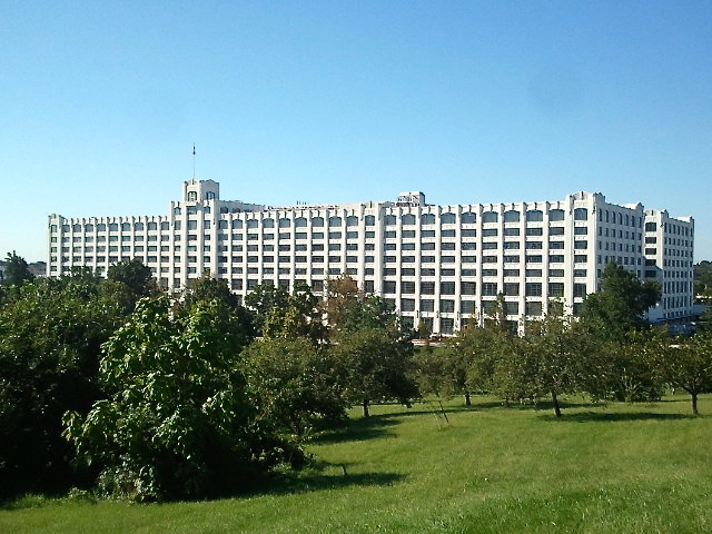
Montgomery Park
Monument and historic site · National Register of Historic Places · 2.8 mi
State government office building across from Carroll Park in southwest Baltimore, Maryland, United States

Mount Auburn Cemetery
Monument and historic site · National Register of Historic Places · 1.6 mi
Cemetery in Baltimore, oldest black owned and operated cemetery in the United States

Mount Clare
Monument and historic site · National Register of Historic Places · 3.0 mi
Historic locality in Baltimore, Maryland, United States of America


National Museum of Railroad History & Innovation
Monument and historic site · National Register of Historic Places · 3.4 mi
Museum exhibiting historic railroad equipment in Baltimore, United States
21 more on the map.
Parks, trails and playgrounds22

Carroll Park
Park · 2.9 mi
Urban park and statistical area in Baltimore, Maryland, United States
Robert Baker Park
Park · 3.4 mi
Public pocket park in Baltimore, Maryland, US

Patapsco Valley State Park Belle Grove Area
Hiking and trails · 0.7 mi
Sub-unit of the larger Patapsco Valley State Park.
10 more on the map.
Restaurants and cafes21

Happy Garden
Restaurant · Chinese · 1.6 mi
810 Nursery Road, Linthicum Heights
Mo-Th 10:30-22:00; Fr 10:30-22:30; Sa 11:00-22:30; Su 12:00-22:30
Hot Wok
Restaurant · Chinese · 1.6 mi
452 North Camp Meade Road, Linthicum
Tu off; Mo,We,Th 11:00-22:00; Fr,Sa 11:00-22:30; Su 12:00-22:00

Royal Spice
Restaurant · Indian, Nepalese · 1.6 mi
810 Nursery Road, Linthicum Heights
Mo off; Tu-Th 11:00-15:00,16:00-21:30; Fr 11:00-15:00,...


Dunkin'
Fast food · Donut, Coffee Shop · 1.4 mi
714 Nursery Road, Linthicum Heights
Mo-Fr 04:30-21:00; Sa-Su 05:00-21:00
Dunkin'
Fast food · Donut, Coffee Shop · 1.5 mi
458 North Camp Meade Road, Linthicum
Mo-Fr 04:00-20:00; Sa 04:00-19:00; Su 04:30-19:00
9 more on the map.
History
In the area known as Baltimore Highlands is a legendary mansion called English Consul. The land and house were owned by William Dawson, the first English Consul to Maryland. One legend claims that Dawson had a brother who was transported from England to America in disgrace. Each year he was to receive a whip lashing as punishment for the crime he had committed. This took place on the English Consul estate. Another legend has it that the mansion was a stop on the Underground Railroad before the Civil War. In 1909 a developer purchased the estate. It was eventually divided into the areas known as Baltimore Highlands, Rosemont, Friendship Gardens and the small section still called English Consul.
In the 1980s Baltimore County Recreation and Parks opened a large parcel of land for public use. Southwest Area Park is located on the Patapsco River just below Baltimore Highlands.
From the History section of Baltimore Highlands, Maryland on Wikipedia, under CC BY-SA 4.0.
Where to stay3
Comfort Inn and Suites BWI Airport
Motel and hotel · 1.5 mi
6921 Baltimore Annapolis Boulevard, Baltimore
Churches and places of worship23
Dorguth Memorial United Methodist Church
Church · National Register of Historic Places · 3.2 mi
Lansdowne Christian Church
Church · National Register of Historic Places · 1.5 mi
Leadenhall Street Baptist Church
Church · National Register of Historic Places · 3.0 mi
Hemingway Chapel African Methodist Episcopal Church
Church · Methodist · 1.1 mi
823 Cherry Hill Road, Brooklyn
Masjid Bilal
Place of worship · Sunni · 1.5 mi
3735 South Hanover Street, Baltimore
Shopping4
Gas and EV charging12
Schools, colleges and libraries59
Benjamin Franklin High School At Masonville Cove
School · 2.4 mi
1201 Cambria Street, Baltimore
Healthcare2
DaVita Harbor Park Dialysis
Clinic and pharmacy · 1.5 mi
111 Cherry Hill Road, Baltimore
Map of Baltimore Highlands
180 places. The map loads OpenStreetMap tiles when you open it.
Climate by month
Monthly table
| Month | High | Low | Rain |
|---|---|---|---|
| Jan | 44°F | 30°F | 3.1 in |
| Feb | 47°F | 32°F | 2.8 in |
| Mar | 55°F | 39°F | 3.9 in |
| Apr | 67°F | 48°F | 3.5 in |
| May | 76°F | 58°F | 3.4 in |
| Jun | 85°F | 68°F | 3.4 in |
| Jul | 90°F | 73°F | 4.7 in |
| Aug | 87°F | 71°F | 4.3 in |
| Sep | 80°F | 64°F | 4.5 in |
| Oct | 69°F | 53°F | 3.5 in |
| Nov | 58°F | 43°F | 3.0 in |
| Dec | 48°F | 35°F | 3.7 in |
U.S. Climate Normals 1991-2020 for Md Sci Ctr Baltimore Hcn (3 mi away), NOAA NCEI.
People and cost of living
American Community Survey 5-year estimates, 2020-2024, U.S. Census Bureau. Estimates have margins of error, larger for small towns.
Disaster history
Baltimore County has had 17 federal disaster declarations since 2000, most often for hurricanes.
- 2026-01-24: Severe Winter Storm (Winter Storm)
- 2020-03-26: Covid-19 Pandemic (Biological)
- 2020-03-13: Covid-19 (Biological)
- 2018-07-02: Severe Storm And Flooding (Flood)
- 2016-03-04: Severe Winter Storm And Snowstorm (Snowstorm)
- 2014-04-10: Snowstorm (Severe Storm)
OpenFEMA disaster declarations summaries.
Getting there and nearby towns
Baltimore-Washington International/Thurgood Marshall Airport (BWI) is the nearest airport with scheduled flights listed in OpenStreetMap, 5 miles away.
- Brooklyn Park 1 mi southeast, about 2 min by car
- Linthicum 2 mi southwest, about 4 min by car
- Arbutus 3 mi west, about 5 min by car
- Ferndale 3 mi south, about 5 min by car
- Baltimore 5 mi north, about 7 min by car
- Glen Burnie 6 mi south, about 9 min by car
- Catonsville 6 mi west, about 10 min by car
- Elkridge 6 mi southwest, about 10 min by car
- Ilchester 7 mi west, about 11 min by car
- Pasadena 7 mi southeast, about 11 min by car
Drive times are estimates from straight-line distance, not routes.
Local news
Headlines from INDB, the NEMICO news database.
Reviews, tips and questions
Loading what members have shared...
Sources and licences
- NCES EDGE (Public domain): public schools
- NOAA NCEI U.S. Climate Normals 1991-2020 (Public domain): climate by month
- OpenFEMA (Public domain): disaster declarations
- OpenStreetMap contributors (ODbL 1.0): places, airports, map data
- U.S. Census Bureau (Public domain): population, income, housing, education, commute
- Wikidata (CC0 1.0): landmarks and historic places
- Wikimedia Commons (see each image): photos
- Wikipedia (CC BY-SA 4.0): overview and history text
Photo credits
- Baltimore Highlands station, Mitchazenia, CC BY-SA 4.0
- 2020-08-06 13 48 05 View north along Maryland State Route 648 (Annapolis Road) from the overpass for Interstate 895 (Baltimore Harbor Tunnel Thruway) in Baltimore Highlands, Baltimore County, Maryland, Famartin, CC BY-SA 4.0
- 2020-08-06 13 46 14 View south along Maryland State Route 648 (Annapolis Road) from the overpass for Interstate 895 (Baltimore Harbor Tunnel Thruway) in Baltimore Highlands, Baltimore County, Maryland, Famartin, CC BY-SA 4.0
- Baltimore Highlands Light Rail Station - Baltimore to Philadelphia (3325850088), brewbooks from near Seattle, USA, CC BY-SA 2.0
- 2019-06-20 12 46 50 View south along Interstate 895 (Baltimore Harbor Tunnel Thruway) at Exit 4 (Maryland State Route 295 SOUTH-Baltimore-Washington Parkway) in Baltimore Highlands, Baltimore County..., Famartin, CC BY-SA 4.0
- 2016-05-11 08 11 37 View north along the Baltimore-Washington Parkway (Maryland State Route 295) just north of the Baltimore Harbor Tunnel Thruway (Interstate 895) along the edge of Lansdowne and..., Famartin, CC BY-SA 4.0
- 2016-07-27 08 08 31 View south along Maryland State Route 648 (Annapolis Road) entering Baltimore Highlands, Baltimore County, Maryland from Baltimore City, Maryland, Famartin, CC BY-SA 4.0
- 2019-09-08 14 58 52 View north along Maryland State Route 295 (Baltimore-Washington Parkway) at the exit for Interstate 895 NORTH (Baltimore Harbor Tunnel Thruway) on the edge of Lansdowne and..., Famartin, CC BY-SA 4.0
- 2020-08-05 17 50 19 View south along Maryland State Route 648 (Annapolis Road) entering Baltimore Highlands, Baltimore County, Maryland from Baltimore City, Maryland, Famartin, CC BY-SA 4.0
- 2016-05-11 08 04 09 View south along the Baltimore-Washington Parkway (Maryland State Route 295) just south of the Baltimore city limits along the edge of Lansdowne and Baltimore Highlands in..., Famartin, CC BY-SA 4.0
- Mount Clare Baltimore MD Dec 11, Pubdog, Public domain
- Mount Auburn Cemetery Baltimore, Maryland Dec 11, Pubdog, Public domain
- Sunnyfields Dec 09, Pubdog ( talk ), Public domain
- Holy Cross Roman Catholic Church Baltimore MD Dec 11, Pubdog, Public domain
- Pigtown Historic District Baltimore MD Dec 11, Pubdog, Public domain
- Twin Oaks Dec 09, Pubdog ( talk ), Public domain
- Walters Bath No. 2 Dec 11, Pubdog, Public domain
- Turkey Hill Dec 09, Pubdog ( talk ), Public domain
- Entrance to Riverside Park, Baltimore MD, Sep 2013, Jmj1000, CC BY-SA 3.0
- Linthicum Heights Historic District View 2 Dec 09, Pubdog ( talk ), Public domain
- B&O Mount Clare Station (Baltimore), JGHowes, Attribution
- Montgomery Ward Warehouse and Retail Store, Phaneros, CC BY-SA 3.0
- Leadenhall Street Baptist Church Dec 11, Pubdog, Public domain
- Barre Circle HD Bmore, Smallbones, CC0
- Baltimore Parker Metal, Smallbones, CC0
- Little Montgomery Street Historic District Dec 11, Pubdog, Public domain
- Carrollton-viaduct, William Edmund Barrett, Historic American Engineering Record, Public domain
- Benson-Hammond House Dec 09, Pubdog ( talk ), Public domain
- Baltimore (tugboat), Baltimore, Maryland, Candace Clifford, National Park Service photographer, Public domain
- Methodist 1857 Baltimore MD, Smallbones, CC0
- Hull Memorial Christian Church Dec 09, Pubdog ( talk ), Public domain
- Southern District Police Station Baltimore MD Dec 11, Pubdog, Public domain
- Maryland White Lead Works Dec 11, Pubdog, Public domain
- Polish Home Hall Dec 11, Pubdog, Public domain
- Equitable gas Baltimore, Smallbones, CC0
- Old Coke Baltimore, Smallbones, CC0
- Baltimore & Ohio Railroad, Howard Street Tunnel, 1300 Mount Royal Avenue (Baltimore, Maryland), William Edmund Barrett, Public domain
- National Enameling and Stamping Company Dec 11, Pubdog, Public domain
- Hanover street bridge baltimore, Patorjk, CC BY-SA 4.0
- SportsLegendsMuseumCamdenYards, AndrewHorne, Public domain


Page built October 30, 2026. Spotted a mistake? Tell us or suggest a place.