
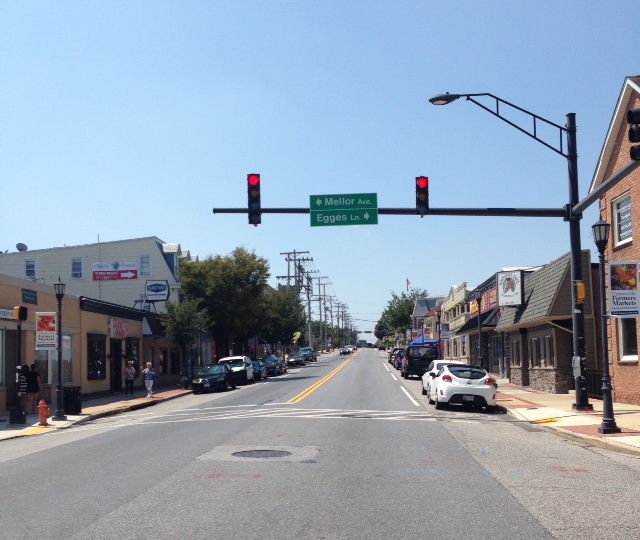


Catonsville, Maryland
Catonsville is a community of 43,368 people in Baltimore County, Maryland, founded in January 20, 1831.
Why visit Catonsville
Townapedia lists 84 museums and landmarks, 74 parks and trails, 198 places to eat, 13 places to stay and 22 attractions in and around town.
Highlights include R/C Hollywood Cinema 4, AMC Security Square 8, Ellicott City B&O Railroad Station Museum and Ellicott City Historic District.
July is the warmest month, with average highs of 90°F; January lows average 30°F.
Weather in Catonsville
Forecast from the National Weather Service. Full forecast
About Catonsville
Catonsville () is a town in Baltimore County, Maryland, United States. The population was 44,701 at the 2020 US Census. The community is a streetcar suburb of Baltimore along the city's western border. The town is known for its proximity to the Patapsco River and Patapsco Valley State Park, making it a regional mountain biking hub.
From the Wikipedia article Catonsville, Maryland (this version), under CC BY-SA 4.0.
Things to do22


Patapsco Swinging Bridge
Bridge · 1.6 mi
Pedestrian suspension bridge in Maryland


10 more on the map.
Museums and landmarks84

Ellicott City B&O Railroad Station Museum
Museum · 2.8 mi
2711 Maryland Avenue, Ellicott City
We,Th 10:00-15:00; Fr-Su 10:00-17:00

Ellicott City Historic District
Monument and historic site · National Register of Historic Places · 2.9 mi
Historic district in Maryland, United States

Mount de Sales Academy
Monument and historic site · Roman Catholic · National Register of Historic Places · 1.9 mi
School in Baltimore County, Maryland
700 Academy Road, Catonsville

Baltimore National Cemetery
Monument and historic site · National Register of Historic Places · 2.0 mi
United States national cemetery in Baltimore and Baltimore County, Maryland

Carrollton Viaduct
Monument and historic site · National Register of Historic Places · 4.7 mi
Bridge in United States of America

Central Catonsville and Summit Park Historic District
Monument and historic site · National Register of Historic Places
Historic district in Maryland, United States

Curtis-Shipley Farmstead
Monument and historic site · National Register of Historic Places · 4.6 mi
Building in Maryland, United States
Dickeyville Historic District
Monument and historic site · National Register of Historic Places · 4.1 mi
Historic district coincident with the neighborhood of Dickeyville, Baltimore, Maryland

Dorsey Hall
Monument and historic site · National Register of Historic Places · 5.1 mi
Building in Maryland, United States
Edmondson Avenue Historic District
Monument and historic site · National Register of Historic Places · 4.8 mi
Historic district in Maryland, United States

Elkridge Furnace Complex
Monument and historic site · National Register of Historic Places · 4.1 mi
Building in Maryland, United States


Ellicott City Station
Monument and historic site · National Register of Historic Places · 2.8 mi
Railway station in Ellicott City, the United States of America
72 more on the map.
Parks, trails and playgrounds74

Benjamin Banneker Historical Park and Museum
Park · 1.8 mi
A park and museum commemorating free African-American naturalist Benjamin Banneker
Gwynn Oak Park
Park · 4.6 mi
Former amusement park in Maryland, US from 1893 to 1973
Gwynns Falls/Leakin Park
Park · 4.0 mi
Urban park and statistical area in Baltimore, Maryland, United States
Rockburn Branch Park
Park · 3.3 mi
Park in Howard County, Maryland, United States of America

Patapsco Gateway - FPVSP
Hiking and trails · 1.7 mi
Sub-unit of the larger Patapsco Valley State Park.
Patapsco Valley State Park Avalon Area
Hiking and trails · 2.9 mi
Sub-unit of the larger Patapsco Valley State Park.
Patapsco Valley State Park Glen Artney Area
Hiking and trails · 1.9 mi
Sub-unit of the larger Patapsco Valley State Park.
62 more on the map.
Restaurants and cafes198

La Palapa Grill & Cantina
Restaurant · Mexican · 3.1 mi
Restaurant serving high quality Mexican cuisine in a Hacienda decor setting, with live Mariachi music on weekends.
8307 Main Street, Ellicott City
Tu-Th 12:00-21:00; Fr 11:00-22:00; Sa 10:00-22:00; Su 10:00-21:00

Atwater's
Cafe · American, Breakfast, Coffee Shop, Sandwich · 0.6 mi
815 Frederick Road, Catonsville
Mo-Tu 07:00-18:00; We-Fr 07:00-21:00; Sa 08:00-21:00; Su 08:00-16:00
Doozy’s Diner
Restaurant · Breakfast, Diner · 0.7 mi
10 Mellor Avenue, Catonsville
Mo, Th-Fr 07:00-14:30; Sa-Su 08:00-14:00
Georgia Grace Cafe
Cafe · Sandwich, Breakfast, Crepe · 3.1 mi
8333 Main Street, Ellicott City
We-Su 08:00-17:00
Grace Cafe
Restaurant · Chinese, Japanese, Sushi · 2.8 mi
5201 East Drive, Halethorpe
Mo-Th 10:30-22:00; Fr 10:30-23:00; Sa 11:00-23:00; Su 12:00-22:00
IHOP
Restaurant · Breakfast, Pancake · 2.1 mi
5525 Baltimore National Pike, Catonsville
Mo-Su 07:00-23:00; PH off
Lima’s Chicken
Restaurant · Chicken, Peruvian · 1.7 mi
6473 Baltimore National Pike, Catonsville
Mo-Su 11:00-21:00
Little Market Cafe
Cafe · Breakfast, Coffee Shop, Sandwich · 3.0 mi
3731 Hamilton Street, Ellicott City
Tu-Th 09:00-15:00; Fr-Sa 09:00-20:00; Su 09:00-17:00
Old Mill Cafe
Cafe · Bagel, Breakfast, Coffee Shop, Crepe, Sandwich · 2.7 mi
4 Frederick Road, Oella
Mo-Tu, Th-Fr 07:00-15:00; Sa-Su 08:00-16:00
Peace A Pizza
Restaurant · Pizza · 0.6 mi
15 Mellor Avenue, Catonsville
Mo-Th 11:00-19:00; Fr 11:00-20:00; Sa 11:00-19:00; Su off
Pho Saigon
Restaurant · Vietnamese · 1.6 mi
1116 North Rolling Road, Catonsville
Tu off; Mo,We-Sa 11:00-22:00; Su 10:00-21:00
Phoenix Upper Main
Restaurant · American, Burger, Fish And Chips, Sandwich · 3.1 mi
8308 Main Street, Ellicott City
Su, Tu-Th 12:00-00:00; Fr-Sa 12:00-02:00
186 more on the map.
Where to stay13
Home Style Inn
Motel and hotel · 1.6 mi
6401 Baltimore National Pike, Catonsville
Holiday Inn Express & Suites
Motel and hotel · 1.7 mi
5701 Baltimore National Pike, Catonsville
Churches and places of worship70
Lansdowne Christian Church
Church · National Register of Historic Places · 4.4 mi
Mount Gilboa Chapel
Church · National Register of Historic Places · 2.1 mi
Old Salem Church and Cemetery
Church · National Register of Historic Places · 1.5 mi
St. Mary's Episcopal Church
Church · National Register of Historic Places · 3.6 mi
Shopping56
Gas and EV charging31
Schools, colleges and libraries92
Baltimore County Public Library - Catonsville Branch
Library · 0.5 mi
1100 Frederick Road, Catonsville
Healthcare18
Key Point Health Services, Catonsville Clinic
Clinic and pharmacy · 1.3 mi
500 North Rolling Road, Catonsville
Concentra Urgent Care
Clinic and pharmacy · 3.1 mi
1419 Knecht Avenue, Halethorpe
Catonsville Pharmacy
Clinic and pharmacy · 1.6 mi
6350 Frederick Road, Catonsville
Former Gundry/Glass Hospital (Grand Gundry Sanitarium)
Hospital · 2.8 mi
2 North Wickham, Baltimore
MedStar Health Urgent Care
Clinic and pharmacy · 1.8 mi
6500 Baltimore National Pike, Catonsville
Map of Catonsville
250 places. The map loads OpenStreetMap tiles when you open it.
Climate by month
Monthly table
| Month | High | Low | Rain |
|---|---|---|---|
| Jan | 44°F | 30°F | 3.1 in |
| Feb | 47°F | 32°F | 2.8 in |
| Mar | 55°F | 39°F | 3.9 in |
| Apr | 67°F | 48°F | 3.5 in |
| May | 76°F | 58°F | 3.4 in |
| Jun | 85°F | 68°F | 3.4 in |
| Jul | 90°F | 73°F | 4.7 in |
| Aug | 87°F | 71°F | 4.3 in |
| Sep | 80°F | 64°F | 4.5 in |
| Oct | 69°F | 53°F | 3.5 in |
| Nov | 58°F | 43°F | 3.0 in |
| Dec | 48°F | 35°F | 3.7 in |
U.S. Climate Normals 1991-2020 for Md Sci Ctr Baltimore Hcn (7 mi away), NOAA NCEI.
People and cost of living
American Community Survey 5-year estimates, 2020-2024, U.S. Census Bureau. Estimates have margins of error, larger for small towns.
Disaster history
Baltimore County has had 17 federal disaster declarations since 2000, most often for hurricanes.
- 2026-01-24: Severe Winter Storm (Winter Storm)
- 2020-03-26: Covid-19 Pandemic (Biological)
- 2020-03-13: Covid-19 (Biological)
- 2018-07-02: Severe Storm And Flooding (Flood)
- 2016-03-04: Severe Winter Storm And Snowstorm (Snowstorm)
- 2014-04-10: Snowstorm (Severe Storm)
OpenFEMA disaster declarations summaries.
Getting there and nearby towns
Baltimore-Washington International/Thurgood Marshall Airport (BWI) is the nearest airport with scheduled flights listed in OpenStreetMap, 7 miles away.
- Woodlawn 3 mi north, about 5 min by car
- Arbutus 3 mi southeast, about 5 min by car
- Ilchester 3 mi south, about 6 min by car
- Ellicott City 5 mi west, about 8 min by car
- Elkridge 5 mi south, about 8 min by car
- Lansdowne 5 mi southeast, about 7 min by car
- Lochearn 6 mi north, about 9 min by car
- Milford Mill 6 mi north, about 10 min by car
- Linthicum 6 mi southeast, about 9 min by car
- Baltimore 7 mi east, about 12 min by car
Drive times are estimates from straight-line distance, not routes.
Local news
Headlines from INDB, the NEMICO news database.
Reviews, tips and questions
Loading what members have shared...
Sources and licences
- NCES EDGE (Public domain): public schools
- NOAA NCEI U.S. Climate Normals 1991-2020 (Public domain): climate by month
- OpenFEMA (Public domain): disaster declarations
- OpenStreetMap contributors (ODbL 1.0): places, airports, map data
- U.S. Census Bureau (Public domain): population, income, housing, education, commute
- Wikidata (CC0 1.0): elevation, founding date, time zone, website, landmarks and historic places
- Wikimedia Commons (see each image): photos
- Wikipedia (CC BY-SA 4.0): overview and history text
Photo credits
- Catonsville Frederick Road, Scott218, CC BY-SA 4.0
- MDSA, 2KAE at en.wikipedia, Public domain
- Temora Ellicott City MD Jan 11, Pubdog, Public domain
- Curtis-Shipley Farmstead Ellicott City MD Jan 11, Pubdog, Public domain
- Ellicott City Station 1970, William E. Barrett, Public domain
- Central Catonsville and Summit Park Historic District Dec 09, Pubdog ( talk ), Public domain
- MacAlpine Ellicott City MD Jan 11, Pubdog, Public domain
- Oella MD row houses, Finin at en.wikipedia, CC BY-SA 2.5
- South Ellicot City Factory, Nheitjan, CC BY-SA 3.0
- Old Catonsville High School Dec 09, Pubdog ( talk ), Public domain
- Lorraine Park Cemetery Gate Lodge Dec 09, Pubdog ( talk ), Public domain
- Elkridge Furnace Sept 09, Pubdog ( talk ), Public domain
- Winters Lane Historic District Dec 09, Pubdog at en.wikipedia, Public domain
- Lawyers Hill House Sept 09, Pubdog at en.wikipedia, Public domain
- SCHWARTZE MANSION, WEST & SOUTHWEST BALTIMORE, MARYLAND, Jerrye & Roy Klotz, MD, CC BY-SA 4.0
- Weiskittel-Roehle Burial Vault MD1, Acroterion, CC BY-SA 4.0
- The Lawn, Zrmachuga, CC BY-SA 4.0
- St. Charles College Historic District Dec 09, Pubdog ( talk ), Public domain
- Old Salem Church and Cemetery Dec 09, Pubdog ( talk ), Public domain
- Patterson-viaduct, William E. Barrett, Public domain
- Linnwood Ellicott City MD Jan 11, Pubdog, Public domain
- Summit Catonsville MD Dec 09, Pubdog ( talk ), Public domain
- Troy Mansion, Debbieswagner, CC BY-SA 4.0
- The Wilderness Catonsville MD Dec 09, Pubdog ( talk ), Public domain
- Howard School PS 218 Bmore MD, Smallbones, CC0
- Thomas Viaduct LOC 082103pu, Jack Boucher, Public domain
- Gates to White Hall Ellicott City MD Jan 11, Pubdog, Public domain
- Mt. Gilboa African Methodist (A.M.E.) Church 2012, Kadi21228, CC BY-SA 3.0
- Mill on Franklintown Road, Baltimore Maryland, Smallbones, CC0
- Hilton Catonsville MD Dec 09, Pubdog ( talk ), Public domain
- St. Mary's Episcopal Church Woodlawn MD Dec 09, Pubdog ( talk ), Public domain
- Hull Memorial Christian Church Dec 09, Pubdog ( talk ), Public domain
- Dorsey Hall Ellicott City MD Jan 11, Pubdog, Public domain
- Carrollton-viaduct, William Edmund Barrett, Historic American Engineering Record, Public domain
- Woodlawn Columbia MD Jan 11, Pubdog, Public domain
- Elmer V. McCollum House, Pcoussan, CC BY-SA 4.0
- WINDSOR HILLS HISTORIC DISTRICT, BALTIMORE CITY, MD, Jerrye & Roy Klotz, MD, CC BY-SA 4.0
- Baltimore National Cemetery 1, Eminonuk, CC BY-SA 4.0
- Maryland Sons monument, Loudoun Park National Cemetery (Baltimore), Don Woods, CC BY-SA 3.0
- Orphans Asylum Baltimore, Smallbones, CC0


Page built October 30, 2026. Spotted a mistake? Tell us or suggest a place.