


Bardstown, Kentucky
Bardstown is a city of 13,804 people in Nelson County, Kentucky, founded in 1770.
Why visit Bardstown
Townapedia lists 23 museums and landmarks, 5 parks and trails, 42 places to eat, 10 places to stay and 2 attractions in and around town.
Highlights include Keystone Cinemas, Confederate Monument of Bardstown, Bardstown Historic District and My Old Kentucky Home State Park.
July is the warmest month, with average highs of 87°F; January lows average 26°F.
Weather in Bardstown
Forecast from the National Weather Service. Full forecast
About Bardstown
Bardstown is a home rule-class city in Nelson County, Kentucky, United States. The population was 13,567 in the 2020 census. It is the county seat of Nelson County.
From the Wikipedia article Bardstown, Kentucky (this version), under CC BY-SA 4.0.
Things to do2


Museums and landmarks23
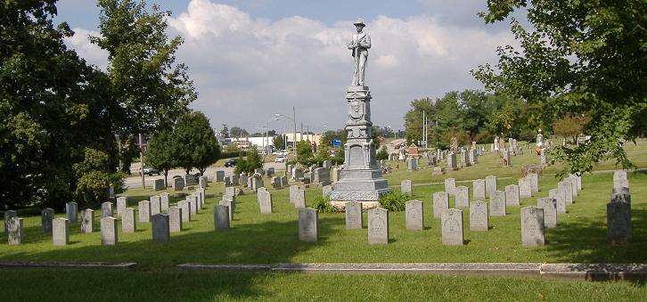
Confederate Monument of Bardstown
Monument and historic site · National Register of Historic Places · 0.6 mi
Sculpture in Kentucky, United States of America

Bardstown Historic District
Monument and historic site · National Register of Historic Places · 0.7 mi
Registered historic district on the National Register of Historic Places
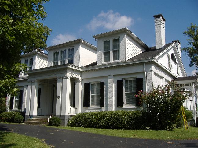
Ben Johnson House
Monument and historic site · National Register of Historic Places · 0.8 mi
Historic house in Bardstown, Kentucky, United States

Cobblestone Path
Monument and historic site · National Register of Historic Places · 0.7 mi
Street

My Old Kentucky Home State Park
Museum · National Register of Historic Places · 0.7 mi
State historic park in Kentucky, United States

Nelson County Jail
Monument and historic site · National Register of Historic Places · 0.9 mi
Prison in Kentucky, United States of America

Old L & N Station
Monument and historic site · National Register of Historic Places · 0.6 mi
Railway station in Bardstown, the United States of America
Spalding Hall
Monument and historic site · National Register of Historic Places · 1.0 mi
Historic building in Bardstown, Kentucky, USA


Wickland
Monument and historic site · National Register of Historic Places · 0.4 mi
Building in Kentucky, United States
Willett Distillery
Monument and historic site · 2.2 mi
1869 Loretto Road
Mo-Sa 09:30-17:30; Su 12:00-16:30
Bourbon Heritage Center
Monument and historic site · 1.8 mi
1311 Gilkey Run Road
Mo-Sa 10:00-17:30; Su 12:00-16:00
11 more on the map.
Parks, trails and playgrounds5



Restaurants and cafes42


BJ's Steakhouse
Diner · American · 0.9 mi
201 Camptown Road, Bardstown
Mo-Th 11:00-20:30; Fr 11:00-21:00; Sa 15:00-21:00; Su off

Cafe Primo
Restaurant · Italian · 0.8 mi
120 North 3rd Street, Bardstown
Simply Seafood Market
Restaurant · Seafood · 2.0 mi
Th-Sa 11:00-20:00; Su 12:00-17:00; PH closed

Rebekah's Pepperoni Grill
Restaurant · Pizza · 1.2 mi
966 Chambers Boulevard, Bardstown

Bardstown Bourbon Company
Brewery and winery · 2.5 mi
1500 Parkway Drive, Bardstown
30 more on the map.
History
First settled in 1780, Bardstown is among the oldest cities in Kentucky. That year, the Old Talbott Tavern was built, a year before the settlement of Salem (later renamed Bardstown) began, making it the "oldest western stagecoach stop" still in operation. Named county seat of the newly created Nelson County, Virginia (now Kentucky) in 1784, the town was formally established in 1788. It was incorporated by the state assembly in 1838.
Reflecting the westward migration of Americans over the Blue Ridge Mountains after the Revolutionary War, Bardstown was also the first center of Catholicism west of the Appalachian Mountains in the original western frontier territories of the United States. The Diocese of Bardstown was established on February 8, 1808, to serve all Catholics between the Appalachians and the Mississippi River. This divided the previous all-encompassing Diocese of Baltimore, established in 1789. In 1841, the seat of the diocese was transferred to nearby Louisville, Kentucky. The Bardstown cathedral is the Basilica of Saint Joseph Proto-Cathedral, and the city has a Roman Catholic parochial high school, Bethlehem High School.
From the History section of Bardstown, Kentucky on Wikipedia, under CC BY-SA 4.0.
Where to stay10
Old Kentucky Home Motel
Motel and hotel · 1.1 mi
414 West Stephen Foster Avenue, Bardstown
Lil patch of Heaven Campground
Campground · 2.3 mi
2289 Templin Avenue, Bardstown
Churches and places of worship15
Basilica of Saint Joseph Proto-Cathedral
Church · Roman Catholic · 1.0 mi
310 West Stephen Foster Avenue, Bardstown
Basilica of St. Joseph Proto-Cathedral
Church · National Register of Historic Places · 1.0 mi
St. Thomas Roman Catholic Church and Howard-Flaget House
Church · National Register of Historic Places · 3.8 mi
Bardstown United Methodist Church
Church · United Methodist · 0.7 mi
116 East Flaget Street, Bardstown
Episcopal Church of the Ascension
Church · Episcopal · 0.7 mi
211 North 3rd Street, Bardstown
First Baptist Church of Bardstown
Church · Baptist · 0.6 mi
315 North 2nd Street, Bardstown
First Christian Church
Church · Disciples Of Christ · 0.6 mi
175 East John Rowan Boulevard, Bardstown
St. John AME Zion Church
Church · African Methodist Episcopal Zion · 0.5 mi
217 East Brashear Avenue, Bardstown
St. Monica Catholic Church
Church · Catholic · 1.3 mi
407 South 3rd Street, Bardstown
Shopping5
Gas and EV charging8
Schools, colleges and libraries21
Nelson County Area Technology Center
School · 1.7 mi
1060 Bloomfield Road, Bardstown
Healthcare3
Medica Pharmacy & Wellness Center
Clinic and pharmacy · 0.9 mi
202 West Stephen Foster Avenue, Bardstown
Map of Bardstown
134 places. The map loads OpenStreetMap tiles when you open it.
Climate by month
Monthly table
| Month | High | Low | Rain | Snow |
|---|---|---|---|---|
| Jan | 43°F | 26°F | 3.7 in | 4.2 in |
| Feb | 48°F | 29°F | 3.9 in | 3.7 in |
| Mar | 57°F | 36°F | 4.9 in | 1.3 in |
| Apr | 69°F | 46°F | 4.7 in | 0.0 in |
| May | 76°F | 55°F | 5.5 in | 0.0 in |
| Jun | 84°F | 63°F | 4.9 in | 0.0 in |
| Jul | 87°F | 66°F | 4.5 in | 0.0 in |
| Aug | 86°F | 64°F | 3.6 in | 0.0 in |
| Sep | 81°F | 58°F | 3.9 in | 0.0 in |
| Oct | 70°F | 47°F | 3.7 in | 0.0 in |
| Nov | 57°F | 37°F | 3.7 in | 0.2 in |
| Dec | 46°F | 30°F | 4.5 in | 2.5 in |
U.S. Climate Normals 1991-2020 for Bardstown 5E (4 mi away), NOAA NCEI.
People and cost of living
American Community Survey 5-year estimates, 2020-2024, U.S. Census Bureau. Estimates have margins of error, larger for small towns.
Disaster history
Nelson County has had 17 federal disaster declarations since 2000, most often for severe storms.
- 2026-01-24: Severe Winter Storm (Winter Storm)
- 2025-04-24: Severe Storms, Straight-Line Winds, Tornadoes, Flooding, Landslides, And Mudslides (Severe Storm)
- 2025-04-03: Severe Storms, Straight-Line Winds, Tornadoes, And Flooding (Severe Storm)
- 2025-02-16: Severe Storms, Straight-Line Winds, Flooding, And Landslides (Severe Storm)
- 2023-04-10: Severe Storms, Straight-Line Winds, Tornadoes, Flooding, Landslides, And Mudslides (Severe Storm)
- 2021-03-31: Severe Winter Storms, Landslides, And Mudslides (Severe Ice Storm)
OpenFEMA disaster declarations summaries.
Getting there and nearby towns
Samuels Field (BRY) is the nearest airport with scheduled flights listed in OpenStreetMap, 2 miles away.
- Bloomfield 10 mi northeast, about 16 min by car
- Loretto 13 mi south, about 20 min by car
- New Haven 13 mi southwest, about 21 min by car
- Lebanon Junction 15 mi west, about 24 min by car
- Mount Washington 16 mi north, about 27 min by car
- Louisville/Jefferson County 26 mi northwest, about 42 min by car
- Jeffersonville 38 mi north, about 1 h by car
- Clarksville 39 mi northwest, about 1 h by car
- New Albany 40 mi northwest, about 1 h by car
- Sellersburg 44 mi northwest, about 1 h 15 min by car
Drive times are estimates from straight-line distance, not routes.
Local news
Headlines from INDB, the NEMICO news database.
Reviews, tips and questions
Loading what members have shared...
Sources and licences
- NCES EDGE (Public domain): public schools
- NOAA NCEI U.S. Climate Normals 1991-2020 (Public domain): climate by month
- OpenFEMA (Public domain): disaster declarations
- OpenStreetMap contributors (ODbL 1.0): places, airports, map data
- U.S. Census Bureau (Public domain): population, income, housing, education, commute
- Wikidata (CC0 1.0): elevation, founding date, time zone, website, landmarks and historic places
- Wikimedia Commons (see each image): photos
- Wikipedia (CC BY-SA 4.0): overview and history text
Photo credits
- Downtown Bardstown, The original uploader was Bedford at English Wikipedia ., Attribution
- Wickland — Bardstown, Kentucky, Christopher L. Riley, CC BY-SA 4.0
- Bruntwood — Bardstown, Kentucky, Christopher L. Riley, CC BY-SA 4.0
- Bruntwood in Bardstown, Nyttend, Public domain
- Beechwold in Bardstown, Nyttend, Public domain
- Bardstown Civil War Museum interior, Kenneth C. Zirkel, CC BY-SA 4.0
- Bardstown Civil War Museum exterior 2016, Kenneth C. Zirkel, CC BY-SA 4.0
- Bardstown Parkview Motel, Kybluegrass, CC BY-SA 3.0
- Old Talbot tavern in Bardstown Kentucky, Patrick Baehl de Lescure, CC BY-SA 4.0
- Old Stone tavern in Bardstown Kentucky, Patrick Baehl de Lescure, CC BY-SA 4.0
- Old Talbott Tavern — Bardstown, Kentucky, Christopher L. Riley, CC BY-SA 4.0
- Spalding Hall Bardstown KY, Kenneth C. Zirkel, CC BY-SA 4.0
- Bardstown Confederate Memorial, Photograph: Bedford at English Wikipedia, Public domain
- Old L & N Station Bardstown, C. Bedford Crenshaw, Attribution
- St-Joseph-Proto-Cathedral-1, Theodore Webb, Public domain
- Old Nelson County Jail, C. Bedford Crenshaw, Attribution
- Wickland 1, C. Bedford Crenshaw, Attribution
- Ben Johnson House, Bedford at English Wikipedia, Public domain
- Cobblestone Path 2, The original uploader was Bedford at English Wikipedia ., Attribution
- Old Talbott Tavern closeup, The original uploader was Bedford at English Wikipedia ., Attribution
- Cottage Grove Farm gates, Nyttend, Public domain
- Cobblestone Path in Summer, Kybluegrass, CC BY-SA 3.0
- Cobblestone Path Quiet Stroll, Kybluegrass, CC BY-SA 3.0
- Kurtz Restaraunt, Kybluegrass, CC BY-SA 3.0
- I Choose Prevention! (8803386556), SAMHSA from Rockville, Public domain
- My Old Kentucky Home Mansion, Firthpond1700, CC BY-SA 4.0
- Pansy cat, Paul to my Linda, CC BY-SA 4.0
- Baldwin's Tourist Court Residence-Office, Nyttend, Public domain
- My Old Kentucky Home Motel, Kybluegrass, CC BY-SA 3.0
- Alianza Apostólica Anticomunista, Casio fx 991, CC BY-SA 4.0
- John S Kelly House, Kybluegrass, CC BY-SA 3.0
- Edgewood, street view, Kybluegrass, CC BY-SA 3.0
- Anytime Fitness (17372188966), Mr. Blue MauMau from USA, CC BY 2.0
- ISS030-E-233637 - View of Earth, Earth Science and Remote Sensing Unit , Lyndon B. Johnson Space Center, Public domain
- ISS050-E-38837 - View of Earth, Earth Science and Remote Sensing Unit , Lyndon B. Johnson Space Center, Public domain
- ISS030-E-230398 - View of Earth, Earth Science and Remote Sensing Unit , Lyndon B. Johnson Space Center, Public domain
- ISS030-E-230397 - View of Earth, Earth Science and Remote Sensing Unit , Lyndon B. Johnson Space Center, Public domain
- ISS030-E-233638 - View of Earth, Earth Science and Remote Sensing Unit , Lyndon B. Johnson Space Center, Public domain
- ISS048-E-60030 - View of Earth, Earth Science and Remote Sensing Unit , Lyndon B. Johnson Space Center, Public domain
- ISS040-E-95882 - View of Earth, Earth Science and Remote Sensing Unit , Lyndon B. Johnson Space Center, Public domain


Page built October 30, 2026. Spotted a mistake? Tell us or suggest a place.