


Chattogram, Bangladesh
চট্টগ্রাম
Chattogram is a regional capital of 3,920,222 people in Chittagong, Bangladesh.
Why visit Chattogram
Townapedia lists 28 museums and landmarks, 39 parks and trails, 107 places to eat, 56 places to stay and 24 attractions in and around town.
Highlights include Asian University for Women, Bangladesh Naval Academy, Zia Memorial Museum and Bangladesh Railway Museum.
Weather in Chattogram
Forecast from MET Norway (CC BY 4.0). Full forecast
About Chattogram
Chittagong, officially Chattogram (Bengali: চট্টগ্রাম, romanized: Côṭṭôgrām, IPA: [ˈt͡ʃɔʈːoɡram] , traditionally Bengali: চাটগাঁও, romanized: Cāṭgão; Chittagonian: চিটাং, romanized: Sitang), is the capital and largest city of the Chittagong Division and Chittagong District. It is the second-largest city in Bangladesh after the capital, Dhaka, and the largest city in the Greater Chittagong region, with a land area of 157 square kilometers. Home to the Port of Chittagong, it is the busiest port in Bangladesh and the Bay of Bengal. The city is also the business capital of Bangladesh.
From the Wikipedia article Chittagong (this version), under CC BY-SA 4.0.
Travel tips from other travellers: Chattogram on Wikivoyage (CC BY-SA 4.0).
Things to do24

Asian University for Women
School · 2.3 km
International university in Chittagong, Bangladesh

Bangladesh Naval Academy
School · 12.7 km
Officer Cadets Training Institution of the Bangladesh Navy

Chattogram BGMEA University of Fashion and Technology
School · 3.5 km
University in Bangladesh
Chittagong Independent University
School · 0.9 km
Private university in Chittagong, Bangladesh

Chittagong Medical University
School · 2.3 km
Public medical university in Bangladesh

Chittagong Veterinary and Animal Sciences University
School · 4.0 km
Public university in Bangladesh

East Delta University
School · 2.8 km
Private university in Chittagong, Bangladesh

Foy's Lake Concord
Monument and historic site · 4.9 km
Amusement park in Bangladesh
Institute of Apparel Management
School · 1.7 km
Educational institution in Chittagong, Bangladesh

Jamiatul Uloom Al-Islamia Lalkhan Bazar
School · 2.5 km
Madrasa in Chittagong District, Bangladesh

Kalurghat Bridge
Bridge · 8.7 km
First bridge built over the Karnaphuli in Chattogram, Bangladesh

12 more on the map.
Museums and landmarks28
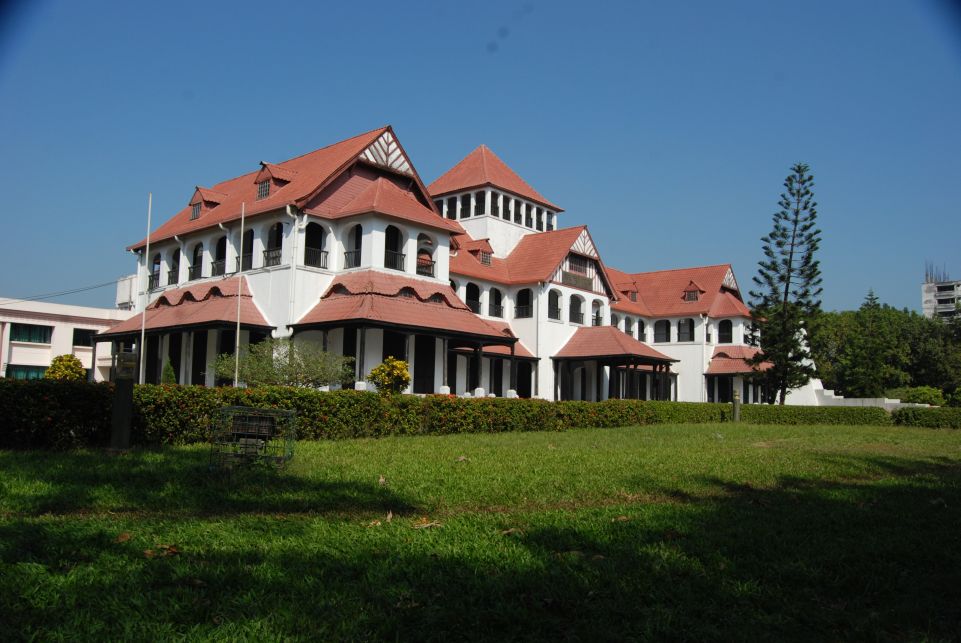

Bangladesh Railway Museum
Museum · 3.6 km
Railway Museum in Chattogram

Bayazid Bostami Shrine (Chittagong)
Monument and historic site · 6.1 km
Shrine in Chittagong, Bangladesh


Seafarers' Memorial
Monument and historic site · 10.7 km
Memorial at the Bangladesh Marine Academy

Cheragi Pahar
Monument and historic site · 0.6 km
Cultural and historical place in Chittagong.




Artist Rashid Choudhury Art Gallery, Institute of Fine Arts, University of Chattogram, Chattogram
Museum · 1.9 km

16 more on the map.
Parks, trails and playgrounds39




Chittagong Collegiate School outer Playground, Ice Factory Rd, Chattogram
Playground · 1.0 km
City Govt. Girls High School Playgroud, N Nalapara Rd, Chattogram
Playground · 0.8 km
27 more on the map.
Restaurants and cafes107

Cafe71 (RF-Police Plaza)
Restaurant · Regional, Fish And Chips, Coffee Shop
Nandan Kanon Road, Chittagong
sunrise-sunset

Waffle Scoop
Cafe · Ice Cream, Dessert, Coffee Shop · 2.2 km
4320 M M Ali Road, Chittagong, Bangladesh
Mo-Su 10am - 3am

Cheese Mania
Restaurant · Burger, Pizza, Ice Cream, Coffee Shop, Chicken · 1.1 km
Saifuddin Khaled Road, Chittagong

Adar Hasan Bakery and Confectionery, Sajeda Super Market, Natun Bridge, Natun Chaktai, Chattogram
Bakery · 2.1 km
Bhai Bhai Hotel & Restaurant, Alom Hotel Mor, West Madarbari, Agrabad, Chattogram
Restaurant · 1.7 km
95 more on the map.
History
Stone Age fossils and tools unearthed in the region indicate that Chittagong has been inhabited since Neolithic times. It is an ancient port city, with a recorded history dating back to the 4th century BC. Its harbour was mentioned in Ptolemy's world map in the 2nd century as one of the most impressive ports in the East. The region was part of the ancient Bengali Samatata and Harikela kingdoms. The Chandra dynasty once dominated the area and was followed by the Varman dynasty and Deva dynasty.
Chinese traveller Xuanzang described the area as "a sleeping beauty rising from mist and water" in the 7th century.
Many Sufi missionaries settled in Chittagong and played an instrumental role in the spread of Islam.
Sultan Fakhruddin Mubarak Shah of Sonargaon conquered Chittagong in 1340, making it a part of Sultanate of Bengal. It was the principal maritime gateway to the kingdom, which was reputed as one of the wealthiest states in the Indian subcontinent. Medieval Chittagong was a hub for maritime trade with China, Sumatra, the Maldives, Sri Lanka, the Middle East, and East Africa. It was notable for its medieval trades in pearls, silk, muslin, rice, bullion, horses, and gunpowder. The port was also a major shipbuilding hub.
From the History section of Chittagong on Wikipedia, under CC BY-SA 4.0.
Where to stay56
Al Makkah Hotel & Biriyani House, Sadarghat Rd, Chattogram
Motel and hotel · 1.1 km
Ali Akbar Hotel, D. T. Road, West Madarbari, Railgate, Chattogram
Motel and hotel · 1.2 km
Commerce College student Hostel, Commerce College Road, Chattogram
Motel and hotel · 2.1 km
Hotel Al-Amin and Restaurant, Kazi Nazrul Islam Rd, Chattogram
Motel and hotel · 1.1 km
Churches and places of worship113
Chaktai Boro Masjid
Place of worship · Islamic Prayer · 1.7 km
Chaktai Boro Masjid Road, Chittagong
Mehedibag CDA Colony Mosque
Place of worship · Muslim/islam · 2.2 km
Mehedibagh Road, Chittagong, Bangladesh
Shopping64
HNN Depatmental Store
Shopping center · 1.8 km
82, High Level Road, Lalkhan Bazar, Chittagong., Chittagong
Gas and EV charging10
S. Alam Filling Station, Huseyn Shaheed Suhrawardy Rd, Chattogram
Gas station · 0.7 km
Schools, colleges and libraries89
Ahmadiya Hasimia Ismailiya Sunniya Hefejkhana Atimkhana Abtedayi O Forkaniya Madrasa, Chattogram
School · 0.9 km
Alkaran Sultan Ahmed Dewan Girls High School, Alkaran Road, Chattogram
School · 0.7 km
Healthcare73
AB Healthcare & Medicine Shop, Kazi Nazrul Islam Rd, Chattogram
Clinic and pharmacy · 1.0 km
Afif Medical Centre, Jugi Chand Mosjid Ln, Chattogram
Clinic and pharmacy · 1.6 km
Al Aksa Pharmacy, Amnat khan Tower, Dewanhat Overbridge, Dhaka Trunk Rd, Chattogram
Clinic and pharmacy · 1.9 km
Allahr Dan Pharmacy, Bar Quater, Mugoltoli Bazar, Agrabad, Chattogram
Clinic and pharmacy · 1.8 km
Arkid Medicine Center, Noshu Malum Lane, East Mother Bari, Chattogram
Clinic and pharmacy · 1.1 km
Map of Chattogram
250 places. The map loads OpenStreetMap tiles when you open it.
Getting there and nearby towns
Shah Amanat International Airport (CGP) is the nearest airport with scheduled flights listed in OpenStreetMap, 10 km away.
- Patiya 16 km east, about 16 min by car
- Hāthazāri 19 km north, about 19 min by car
- Raojān 24 km north, about 24 min by car
- Dohazāri 32 km southeast, about 32 min by car
- Sātkania 37 km southeast, about 37 min by car
- Bibir Hat 39 km north, about 39 min by car
- Bāndarban 43 km east, about 43 min by car
- Sandwīp 43 km northwest, about 43 min by car
- Rangamati 50 km northeast, about 50 min by car
- Karnaphuli 57 km northeast, about 57 min by car
Drive times are estimates from straight-line distance, not routes.
Local news
Headlines from INDB.
Reviews, tips and questions
Loading what members have shared...
Sources and licences
- GeoNames (CC BY 4.0): population, coordinates, regions and time zone
- OpenStreetMap contributors (ODbL 1.0): places, airports, map data
- Wikidata (CC0 1.0): elevation, founding date, time zone, website, landmarks and historic places
- Wikimedia Commons (see each image): photos
- Wikipedia (CC BY-SA 4.0): overview and history text
Photo credits
- Portal of Bangladesh Naval Academy (07), Aminulbn, CC BY-SA 3.0
- Chittagong Medical University Building, Rafi Bin Tofa, CC BY-SA 4.0
- CVASU gate 2, Rafi Bin Tofa, CC BY-SA 4.0
- Entrance of the East Delta University 02, Kritzolina, CC BY-SA 4.0
- Foy's Lake Concord (2Q7A0334), Moheen Reeyad, CC BY-SA 4.0
- আইএএম - লোগো, Mohammad Z. Islam, CC0
- A Glimpse of Kalurghat Bridge, Chittagong, ShifayetH, CC BY-SA 4.0
- Bangladesh Railway Museum, Chattogram (2Q7A0322), Moheen Reeyad, CC BY-SA 4.0
- Entrance of Ethnological Museum (03), Moheen Reeyad, CC BY-SA 4.0
- Seafarers Memorial BMA, Shafi aszad, CC BY-SA 3.0
- Biplobi Uddyan 003, Azim Al Jabber, CC BY-SA 3.0
- Chittagong Zoo - 2, IqbalHossain, CC BY-SA 3.0
- Jamburi park, Agrabad, Chittagong 1, Great Hero32, CC BY-SA 4.0
- Patharghatta Catholic Church Chittagong, Bazaan, CC BY-SA 3.0
- Zia Museum 001, Azim Al Jabber, CC BY-SA 3.0
- Chandanpura Masjid, Chittagong, Bangladesh, Astrothomas, CC BY 3.0
- Chatteshwari Temple Close View, Risadul Islam (Foisal), CC BY-SA 4.0
- Chittagong War Cemetery, Chattogram, Bangladesh (2), Md. T Mahtab, CC BY-SA 4.0
- BuddhaBihar4, Swomitra, CC BY-SA 3.0
- Cheragi Pahar Circle (01), Moheen Reeyad, CC BY-SA 4.0
- Chattogram Central Shaheed Minar - 3, Iqbal Hossain, CC BY-SA 4.0
- Church of the Immaculate Conception, Chittagong (02), Moheen Reeyad, CC BY-SA 4.0
- Mullah Miskin Mosque, Risadul Islam (Foisal), CC BY-SA 4.0
- Chittagong City Corporation Public Library gate, Al Riaz Uddin, CC BY-SA 4.0
- Chittagong City Corporation Public Library gate 3, Al Riaz Uddin, CC BY-SA 4.0
- Central Railway Building (17233793446), Omar Faruk.bd from Dhaka, Bangladesh, CC BY 2.0
- Shrine of Bayazid Bostami Gate Rohan, Rohan Uddin Fahad, CC BY-SA 3.0
- Academic building, Jamiatul Uloom Al-Islamia Lalkhan Bazar 3, Owais Al Qarni, CC BY-SA 4.0
- Chatteshwari Temple Front View, Risadul Islam (Foisal), CC BY-SA 4.0
- War cemetery, Chattogram 04, Noor foysal kaium, CC BY-SA 4.0
- কাট্টলী সমুদ্র সৈকত, রহিম সৈকত, CC BY-SA 4.0
- Chittagong Central Shaheed Minar on 21 February 2025, Owais Al Qarni, CC BY-SA 4.0
- Chttagram Town(1), চিত্রকথক, CC BY-SA 4.0
- Tareque Masud during a premiere of the film Runway label QS:Len,"Tareque Masud during a premiere of the film Runway ", Moheen Reeyad, CC BY-SA 4.0
- Tareque Masud during a premiere of the film Runway label QS:Len,"Tareque Masud during a premiere of the film Runway ", Moheen Reeyad, CC BY-SA 4.0
- Tareque Masud during a premiere of the film Runway label QS:Len,"Tareque Masud during a premiere of the film Runway ", Moheen Reeyad, CC BY-SA 4.0
- Tareque Masud during a premiere of the film Runway label QS:Len,"Tareque Masud during a premiere of the film Runway ", Moheen Reeyad, CC BY-SA 4.0
- Tareque Masud during a premiere of the film Runway label QS:Len,"Tareque Masud during a premiere of the film Runway ", Moheen Reeyad, CC BY-SA 4.0
- Tareque Masud during a premiere of the film Runway label QS:Len,"Tareque Masud during a premiere of the film Runway ", Moheen Reeyad, CC BY-SA 4.0
- Tareque Masud during a premiere of the film Runway label QS:Len,"Tareque Masud during a premiere of the film Runway ", Moheen Reeyad, CC BY-SA 4.0
- Entrance, Asian University for Women (02), Moheen Reeyad, CC BY-SA 4.0


Page built November 4, 2026. Spotted a mistake? Tell us or suggest a place.