


Why visit Bel Air
Townapedia lists 37 museums and landmarks, 34 parks and trails, 95 places to eat and 2 attractions in and around town.
Highlights include Hays House, Heighe House, Aquila Scott Park and Bynum Run Park.
July is the warmest month, with average highs of 86°F; January lows average 25°F.
Weather in Bel Air
Forecast from the National Weather Service. Full forecast
Things to do2


Museums and landmarks37

Hays House
Museum · National Register of Historic Places
Historic house in Maryland, United States
324 Kenmore Avenue, Bel Air

Heighe House
Monument and historic site · National Register of Historic Places · 1.1 mi
Historic house in Maryland, United States

Odd Fellows Lodge
Monument and historic site · National Register of Historic Places
Historic building in Maryland, US
21 East Pennsylvania Avenue, Bel Air
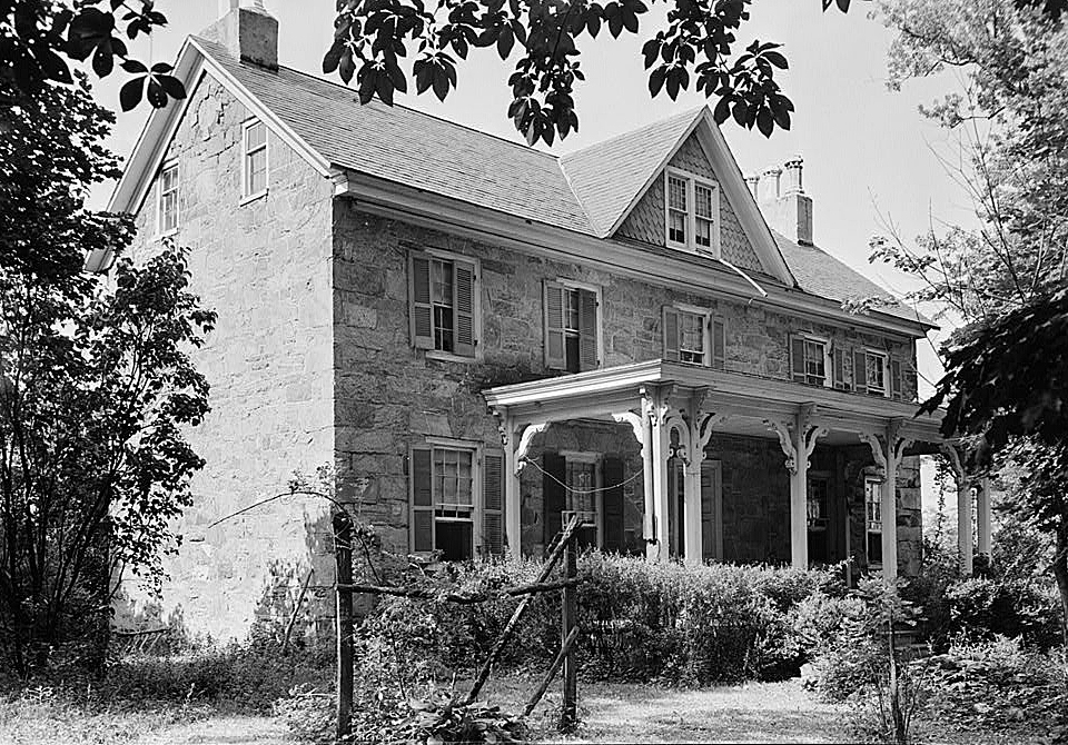
Proctor House
Monument and historic site · National Register of Historic Places · 0.5 mi
Historic house in Maryland, United States
54 East Gordon Street, Bel Air North

Bel Air Armory
Monument and historic site · National Register of Historic Places
Arsenal in Maryland, United States of America

Bel Air Courthouse Historic District
Monument and historic site · National Register of Historic Places · 1.0 mi
Park in Maryland, United States of America, United States of America
Broom's Bloom
Monument and historic site · National Register of Historic Places · 3.7 mi
Historic home located at Bel Air, Harford County, Maryland, United States
Dibb House
Monument and historic site · National Register of Historic Places · 2.5 mi
Historic house in Maryland, United States
Graham-Crocker House
Monument and historic site · National Register of Historic Places
Historic house in Maryland, United States
Graystone Lodge
Monument and historic site · National Register of Historic Places · 2.1 mi
Building in Maryland, United States
Harford National Bank
Monument and historic site · National Register of Historic Places
Historic building in Bel Air, Maryland, US

Hays-Heighe House
Monument and historic site · National Register of Historic Places · 3.8 mi
Historic house in Maryland, United States
25 more on the map.
Parks, trails and playgrounds34





22 more on the map.
Restaurants and cafes95

Akira Ramen
Restaurant · Ramen · 1.0 mi
125 North Tollgate Road, Bel Air
Mo-Th 11:00-21:00; Fr-Sa 11:00-22:00; Su 12:00-21:00

Cold Stone Creamery
Ice cream · Ice Cream · 1.8 mi
1200 Agora Drive, Bel Air
Mo-Th,Su 11:00-21:00; Fr-Sa 11:00-22:00; PH off
Italian Sensation
Restaurant · Italian · 1.2 mi
225 Brierhill Drive, Bel Air
Tu-Sa 11:00-22:00; Su 11:00-21:00

Noodles & Company
Restaurant · Pasta · 0.8 mi
621 Belair Road, Bel Air
Su-We 11:00-21:00; Th-Sa 11:00-22:00
Pizza Hut
Restaurant · Pizza · 1.3 mi
1216 Churchville Road, Bel Air
Mo-Th,Su 10:30-22:00; Fr-Sa 10:30-23:00
Rainbow King
Restaurant · Asian, Japanese · 0.6 mi
554 Baltimore Pike, Bel Air
Mo-Th 11:00-22:00; Fr-Sa 11:00-23:00; Su 12:00-21:00; PH off
Red Robin
Restaurant · Burger · 0.8 mi
606 Baltimore Pike, Bel Air
Su 11:00-21:00;Mo-Th 11:00-22:00;Fr-Sa 11:00-23:00
Rita's Italian Ice
Ice cream · Ice Cream · 1.2 mi
223 Brierhill Drive, Bel Air
Mo-Su 12:00-21:00; PH off
Slices
Restaurant · Pizza · 0.6 mi
549 Baltimore Pike, Bel Air
Mo-Th 08:00-22:00; Fr 08:00-23:00; Sa 09:00-23:00; Su 09:00-22:00
83 more on the map.
Churches and places of worship17
Little Falls Meetinghouse
Church · National Register of Historic Places · 3.7 mi
St. Ignatius Church
Church · National Register of Historic Places · 2.7 mi
St. Mary's Church
Church · National Register of Historic Places · 3.6 mi
Christ Our King Presbyterian Church
Church · Presbyterian Church Usa · 1.5 mi
10 Lexington Road, Bel Air
Four Evangelists Orthodox Church
Church · Ukrainian Orthodox · 0.7 mi
528 North Hickory Avenue, Bel Air
Saint Margaret of Scotland Catholic Church
Church · Roman Catholic · 0.4 mi
141 North Hickory Avenue, Bel Air
Shopping32
Gas and EV charging4
Schools, colleges and libraries34
Healthcare7
University of Maryland Upper Chesapeake Medical Center
Hospital · 1.2 mi
500 Upper Chesapeake Drive, Bel Air
Map of Bel Air
250 places. The map loads OpenStreetMap tiles when you open it.
Climate by month
Monthly table
| Month | High | Low | Rain |
|---|---|---|---|
| Jan | 42°F | 25°F | 3.3 in |
| Feb | 44°F | 27°F | 2.8 in |
| Mar | 52°F | 33°F | 4.1 in |
| Apr | 65°F | 43°F | 3.5 in |
| May | 73°F | 53°F | 4.0 in |
| Jun | 82°F | 62°F | 4.3 in |
| Jul | 86°F | 68°F | 4.8 in |
| Aug | 84°F | 66°F | 4.2 in |
| Sep | 78°F | 59°F | 4.8 in |
| Oct | 67°F | 46°F | 4.2 in |
| Nov | 56°F | 37°F | 3.3 in |
| Dec | 46°F | 30°F | 3.9 in |
U.S. Climate Normals 1991-2020 for Aberdeen Phillips Fld (10 mi away), NOAA NCEI.
People and cost of living
American Community Survey 5-year estimates, 2020-2024, U.S. Census Bureau. Estimates have margins of error, larger for small towns.
Disaster history
Harford County has had 14 federal disaster declarations since 2000, most often for hurricanes.
- 2026-01-24: Severe Winter Storm (Winter Storm)
- 2020-03-26: Covid-19 Pandemic (Biological)
- 2020-03-13: Covid-19 (Biological)
- 2016-03-04: Severe Winter Storm And Snowstorm (Snowstorm)
- 2012-11-20: Hurricane Sandy (Hurricane)
- 2012-10-28: Hurricane Sandy (Hurricane)
OpenFEMA disaster declarations summaries.
Getting there and nearby towns
Phillips Army Air Field (APG) is the nearest airport with scheduled flights listed in OpenStreetMap, 11 miles away.
- Aberdeen 9 mi east, about 15 min by car
- Baltimore 21 mi southwest, about 35 min by car
- Arbutus 27 mi southwest, about 44 min by car
- Glasgow 32 mi east, about 52 min by car
- Newark 33 mi east, about 53 min by car
- Middletown 34 mi east, about 55 min by car
- Arnold 35 mi south, about 56 min by car
- Brookside 35 mi east, about 57 min by car
- Columbia 36 mi southwest, about 58 min by car
- Bear 36 mi east, about 58 min by car
Drive times are estimates from straight-line distance, not routes.
Local news
Headlines from INDB, the NEMICO news database.
Reviews, tips and questions
Loading what members have shared...
Sources and licences
- NCES EDGE (Public domain): public schools
- NOAA NCEI U.S. Climate Normals 1991-2020 (Public domain): climate by month
- OpenFEMA (Public domain): disaster declarations
- OpenStreetMap contributors (ODbL 1.0): places, airports, map data
- U.S. Census Bureau (Public domain): population, income, housing, education, commute
- Wikidata (CC0 1.0): landmarks and historic places
- Wikimedia Commons (see each image): photos
Photo credits
- 2016-06-11 13 11 42 View east along Maryland State Route 22 (Fulford Avenue) at U.S. Route 1 Business and Maryland State Route 924 (Main Street) in Bel Air, Harford County, Maryland, Famartin, CC BY-SA 4.0
- 2016-06-11 13 11 07 View north along U.S. Route 1 Business and Maryland State Route 924 (Main Street) at Maryland State Route 22 (Fulford Avenue) in Bel Air, Harford County, Maryland, Famartin, CC BY-SA 4.0
- 2016-06-11 13 14 11 View north along U.S. Route 1 Business and Maryland State Route 924 (Main Street) at Maryland State Route 22 (Churchville Road) in Bel Air, Harford County, Maryland, Famartin, CC BY-SA 4.0
- Bel Air MD banner, Famartin, CC BY-SA 4.0
- 2019-05-21 13 48 51 View north along U.S. Route 1 Business and Maryland State Route 924 (Main Street) just north of Maryland State Route 22 (Churchville Road) in Bel Air, Harford County, Maryland, Famartin, CC BY-SA 4.0
- 2017-06-02 17 17 11 View west along Maryland State Route 922 (Churchville Road) at U.S. Route 1 Business northbound and Maryland State Route 924 northbound (Main Street) in Bel Air, Harford County..., Famartin, CC BY-SA 4.0
- 2019-08-20 17 56 38 View north along U.S. Route 1 Business (Fulford Avenue) between Maryland State Route 924 southbound (Bond Street) and Maryland State Route 924 northbound (Main Street) in Bel Air..., Famartin, CC BY-SA 4.0
- 2016-06-11 13 31 22 View north along U.S. Route 1 Business (Fulford Avenue) between Maryland State Route 924 southbound (Bond Street) and Maryland State Route 924 northbound (Main Street) in Bel Air..., Famartin, CC BY-SA 4.0
- Harford County Sheriff's Office - Bel Air, Maryland, Farragutful, CC BY-SA 4.0
- 2016-06-11 13 14 26 View north along U.S. Route 1 Business and Maryland State Route 924 (Main Street) at Office Street in Bel Air, Harford County, Maryland, Famartin, CC BY-SA 4.0
- 2017-06-02 17 18 40 View west along Maryland State Route 922 (Churchville Road) at U.S. Route 1 Business southbound and Maryland State Route 924 southbound (Bond Street) in Bel Air, Harford County..., Famartin, CC BY-SA 4.0
- 2016-06-11 12 19 18 View south along U.S. Route 1 Business and Maryland State Route 924 (Bond Street) between Courtland Street and Churchville Road in Bel Air, Harford County, Maryland, Famartin, CC BY-SA 4.0
- 2016-06-11 13 14 33 View north along U.S. Route 1 Business and Maryland State Route 924 (Main Street) between Office Street and Pennsylvania Avenue in Bel Air, Harford County, Maryland, Famartin, CC BY-SA 4.0
- 2016-06-11 13 09 00 View north along Maryland State Route 924 (Main Street) between Eastern Avenue and Baileys Lane in Bel Air, Harford County, Maryland, Famartin, CC BY-SA 4.0
- 2017-06-02 17 20 38 View west along Maryland State Route 922 (Churchville Road) at Hays Street in Bel Air, Harford County, Maryland, Famartin, CC BY-SA 4.0
- 2017-06-02 17 21 19 View west along Maryland State Route 922 (Hays Street) between George Street and U.S. Route 1 Business (Baltimore Pike) in Bel Air, Harford County, Maryland, Famartin, CC BY-SA 4.0
- 2016-06-11 13 14 44 View north along U.S. Route 1 Business and Maryland State Route 924 (Main Street) between Pennsylvania Avenue and Lee Street in Bel Air, Harford County, Maryland, Famartin, CC BY-SA 4.0
- 9-11-12 Bel Air High School, Kevin Mark, CC BY-SA 3.0
- New Hope Baptist - Bel Air, Maryland, Farragutful, CC BY-SA 4.0
- 2019-05-21 13 44 35 A Pin Oak root growing through a cement curb along Shamrock Road in Bel Air, Harford County, Maryland, Famartin, CC BY-SA 4.0
- 2019-05-21 13 44 39 A Pin Oak root growing through a cement curb along Shamrock Road in Bel Air, Harford County, Maryland, Famartin, CC BY-SA 4.0
- St. Margaret's Church - Bel Air, Maryland 04, Farragutful, CC BY-SA 4.0
- Cathedral Church of Reconciliation - Bel Air, Maryland 03, Farragutful, CC BY-SA 4.0
- Cathedral Church of Reconciliation - Bel Air, Maryland 01, Farragutful, CC BY-SA 4.0
- Cathedral Church of Reconciliation - Bel Air, Maryland 02, Farragutful, CC BY-SA 4.0
- Cathedral Church of Reconciliation - Bel Air, Maryland 05, Farragutful, CC BY-SA 4.0
- Cathedral Church of Reconciliation - Bel Air, Maryland 04, Farragutful, CC BY-SA 4.0
- St. Margaret's Church - Bel Air, Maryland 02, Farragutful, CC BY-SA 4.0
- St. Margaret's Church - Bel Air, Maryland 01, Farragutful, CC BY-SA 4.0
- 2019-05-21 13 42 47 View west along Maryland State Route 22 (Main Street) just east of South Shamrock Road in Bel Air, Harford County, Maryland, Famartin, CC BY-SA 4.0
- 2016-06-11 12 17 12 View south along U.S. Route 1 Business and Maryland State Route 924 (Bond Street) between Gordon Street and Lester Way in Bel Air, Harford County, Maryland, Famartin, CC BY-SA 4.0
- St. Margaret's Church - Bel Air, Maryland 03, Farragutful, CC BY-SA 4.0
- HAYS HOUSE, HARFORD COUNTY, Jerrye & Roy Klotz, MD, CC BY-SA 3.0
- Proctor House HABS MD1, E.H. Pickering, HABS photographer, Public domain
- HEIGHE HOUSE, BEL AIR, HARFORD COUNTY, MD, Jerrye & Roy Klotz, MD, CC BY-SA 3.0
- ODD FELLOWS LODGE; BEL AIR, HARFORD COUNTY, Jerrye & Roy Klotz, MD, CC BY-SA 3.0
- HAYS-HEIGHE HOUSE, HARFORD COUNTY, MD, Jerrye & Roy Klotz, MD, CC BY-SA 3.0
- THE VINEYARD,BEL AIR, HARFORD COUNTY, MD, Jerrye & Roy Klotz, MD, CC BY-SA 3.0
- St. Ignatius Church Hickory MD HABS1, E.H. Pcikering, HABS photographer, Public domain
- BEL AIR COURTHOUSE HISTORIC DISTRICT, HARFORD COUNTY, Jerrye & Roy Klotz, MD, CC BY-SA 3.0


Page built October 30, 2026. Spotted a mistake? Tell us or suggest a place.