


Bel Air North, Maryland
Bel Air North is a community of 31,302 people in Harford County, Maryland.
Why visit Bel Air North
Townapedia lists 43 museums and landmarks, 46 parks and trails, 137 places to eat and 2 attractions in and around town.
Highlights include Graystone Lodge, Hays House, Aquila Scott Park and Airbound Sports & Entertainment.
July is the warmest month, with average highs of 86°F; January lows average 25°F.
Weather in Bel Air North
Forecast from the National Weather Service. Full forecast
About Bel Air North
Bel Air North is a census-designated place (CDP) in Harford County, Maryland, United States. It is situated immediately north of (and excludes) the incorporated town of Bel Air. As of the 2010 census, the CDP population was 30,568, up from 25,798 in 2000.
From the Wikipedia article Bel Air North, Maryland (this version), under CC BY-SA 4.0.
Things to do2


Museums and landmarks43

Graystone Lodge
Monument and historic site · National Register of Historic Places · 2.8 mi
Building in Maryland, United States

Hays House
Museum · National Register of Historic Places · 2.0 mi
Historic house in Maryland, United States
324 Kenmore Avenue, Bel Air

Heighe House
Monument and historic site · National Register of Historic Places · 1.9 mi
Historic house in Maryland, United States

Odd Fellows Lodge
Monument and historic site · National Register of Historic Places · 1.7 mi
Historic building in Maryland, US
21 East Pennsylvania Avenue, Bel Air
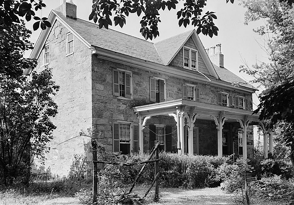
Proctor House
Monument and historic site · National Register of Historic Places · 1.5 mi
Historic house in Maryland, United States
54 East Gordon Street, Bel Air North

Whitaker's Mill Historic District
Monument and historic site · National Register of Historic Places · 3.5 mi
Historic district ion Harford County, Maryland, on the National Register of Historic Places

Bel Air Armory
Monument and historic site · National Register of Historic Places · 1.6 mi
Arsenal in Maryland, United States of America
Bel Air Courthouse Historic District
Monument and historic site · National Register of Historic Places · 1.3 mi
Park in Maryland, United States of America, United States of America
Bon Air
Monument and historic site · National Register of Historic Places · 3.9 mi
Building in Maryland, United States

Dibb House
Monument and historic site · National Register of Historic Places · 3.7 mi
Historic house in Maryland, United States


Graham-Crocker House
Monument and historic site · National Register of Historic Places · 1.7 mi
Historic house in Maryland, United States
Harford National Bank
Monument and historic site · National Register of Historic Places · 1.8 mi
Historic building in Bel Air, Maryland, US
31 more on the map.
Parks, trails and playgrounds46




34 more on the map.
Restaurants and cafes137

Akira Ramen
Restaurant · Ramen · 2.1 mi
125 North Tollgate Road, Bel Air
Mo-Th 11:00-21:00; Fr-Sa 11:00-22:00; Su 12:00-21:00

Baskin-Robbins
Ice cream · Ice Cream · 1.2 mi
35 Osborne Parkway, Forest Hill
Mo-Fr 04:30-21:00; Sa 05:00-21:00; Su 05:00-20:00
Bel Air Pizzeria
Restaurant · Pizza
13 Red Pump Road, Bel Air
Mo-Th 10:30-22:00; Fr-Sa 10:30-23:00; Su 11:00-22:00
China Delight
Restaurant · Chinese · 1.8 mi
1 Newport Drive, Forest Hill
Mo,We-Sa 11:00-21:30; Tu off; Su 12:00-20:30
ChopStix
Restaurant · Chinese · 0.6 mi
1523 Rock Spring Road, Forest Hill
Mo-Th 11:00-21:00; Fr 11:00-22:00; Sa 12:00-22:00; Su 12:00-21:00
Cold Stone Creamery
Ice cream · Ice Cream · 3.1 mi
1200 Agora Drive, Bel Air
Mo-Th,Su 11:00-21:00; Fr-Sa 11:00-22:00; PH off
Enotria
Restaurant · Italian · 1.9 mi
2 Newport Drive, Forest Hill
Mo-Tu off; We-Sa 10:00-22:00; Su 12:00-21:00
Greek Village
Restaurant · Greek · 2.0 mi
129 Baltimore Pike, Bel Air
Mo-Sa 07:00-21:00; Su 07:00-15:00
Hickory Station Pizzeria
Restaurant · Pizza · 1.4 mi
1510 Conowingo Road, Bel Air
Mo-Tu off; We-Th 11:00-20:00; Fr-Sa 11:00-21:00; Su 12:00-20:00
Italian Sensation
Restaurant · Italian · 2.7 mi
225 Brierhill Drive, Bel Air
Tu-Sa 11:00-22:00; Su 11:00-21:00
Kiyomi Sushi
Restaurant · Sushi · 0.4 mi
1443 Rock Spring Road, Bel Air
Mo off; Tu-Th 11:00-15:00,16:30-21:00; Fr 11:00-21:30; Sa...

Main Street Tower
Diner · American · 1.8 mi
29 South Main Street, Bel Air
Mo-Sa 11:00-02:00; Su 09:00-02:00
125 more on the map.
Churches and places of worship34
Little Falls Meetinghouse
Church · National Register of Historic Places · 3.5 mi
St. Ignatius Church
Church · National Register of Historic Places · 1.7 mi
St. Mary's Church
Church · National Register of Historic Places · 5.4 mi
Thomas Run Church
Church · National Register of Historic Places · 5.0 mi
Christ Our King Presbyterian Church
Church · Presbyterian Church Usa · 3.4 mi
10 Lexington Road, Bel Air
Four Evangelists Orthodox Church
Church · Ukrainian Orthodox · 1.4 mi
528 North Hickory Avenue, Bel Air
Shopping44
Gas and EV charging16
Schools, colleges and libraries37
Harford County Public Library - Bel Air Branch
Library · 1.7 mi
100 East Pennsylvania Avenue, Bel Air
Healthcare14
University of Maryland Upper Chesapeake Medical Center
Hospital · 2.8 mi
500 Upper Chesapeake Drive, Bel Air
DaVita Forest Landing Dialysis
Clinic and pharmacy · 1.8 mi
2220 Commerce Road, Forest Hill
Map of Bel Air North
250 places. The map loads OpenStreetMap tiles when you open it.
Climate by month
Monthly table
| Month | High | Low | Rain |
|---|---|---|---|
| Jan | 42°F | 25°F | 3.3 in |
| Feb | 44°F | 27°F | 2.8 in |
| Mar | 52°F | 33°F | 4.1 in |
| Apr | 65°F | 43°F | 3.5 in |
| May | 73°F | 53°F | 4.0 in |
| Jun | 82°F | 62°F | 4.3 in |
| Jul | 86°F | 68°F | 4.8 in |
| Aug | 84°F | 66°F | 4.2 in |
| Sep | 78°F | 59°F | 4.8 in |
| Oct | 67°F | 46°F | 4.2 in |
| Nov | 56°F | 37°F | 3.3 in |
| Dec | 46°F | 30°F | 3.9 in |
U.S. Climate Normals 1991-2020 for Aberdeen Phillips Fld (12 mi away), NOAA NCEI.
People and cost of living
American Community Survey 5-year estimates, 2020-2024, U.S. Census Bureau. Estimates have margins of error, larger for small towns.
Disaster history
Harford County has had 14 federal disaster declarations since 2000, most often for hurricanes.
- 2026-01-24: Severe Winter Storm (Winter Storm)
- 2020-03-26: Covid-19 Pandemic (Biological)
- 2020-03-13: Covid-19 (Biological)
- 2016-03-04: Severe Winter Storm And Snowstorm (Snowstorm)
- 2012-11-20: Hurricane Sandy (Hurricane)
- 2012-10-28: Hurricane Sandy (Hurricane)
OpenFEMA disaster declarations summaries.
Getting there and nearby towns
Phillips Army Air Field (APG) is the nearest airport with scheduled flights listed in OpenStreetMap, 12 miles away.
- Bel Air 2 mi southeast, about 3 min by car
- Fallston 4 mi west, about 6 min by car
- Bel Air South 5 mi southeast, about 7 min by car
- Pleasant Hills 5 mi south, about 8 min by car
- Jarrettsville 6 mi northwest, about 10 min by car
- Kingsville 8 mi southwest, about 12 min by car
- Abingdon 8 mi southeast, about 13 min by car
- Riverside 9 mi southeast, about 14 min by car
- Joppatowne 10 mi south, about 15 min by car
- Edgewood 10 mi southeast, about 16 min by car
Drive times are estimates from straight-line distance, not routes.
Local news
Headlines from INDB, the NEMICO news database.
Reviews, tips and questions
Loading what members have shared...
Sources and licences
- NCES EDGE (Public domain): public schools
- NOAA NCEI U.S. Climate Normals 1991-2020 (Public domain): climate by month
- OpenFEMA (Public domain): disaster declarations
- OpenStreetMap contributors (ODbL 1.0): places, airports, map data
- U.S. Census Bureau (Public domain): population, income, housing, education, commute
- Wikidata (CC0 1.0): elevation, founding date, time zone, website, landmarks and historic places
- Wikimedia Commons (see each image): photos
- Wikipedia (CC BY-SA 4.0): overview and history text
Photo credits
- 2020-06-30 12 35 31 View south along Maryland State Route 924 (Rock Spring Road) at the junction with Maryland State Route 24 from the overpass for U.S. Route 1 (Bel Air Bypass) in Bel Air North..., Famartin, CC BY-SA 4.0
- 2020-06-30 10 36 09 View north along Maryland State Route 24 (Emmorton Road) at the exit for U.S. Route 1 SOUTH-Maryland State Route 24 SOUTH in Bel Air North, Harford County, Maryland, Famartin, CC BY-SA 4.0
- 2020-06-30 12 37 53 View north along Maryland State Route 24 (Rock Spring Road) at the junction with Maryland State Route 924 from the overpass for U.S. Route 1 (Bel Air Bypass) in Bel Air North..., Famartin, CC BY-SA 4.0
- 2019-08-20 17 20 06 View north along U.S. Route 1 and Maryland State Route 24 (Bel Air Bypass) at the exit for Maryland State Route 924 SOUTH (Bel Air) in Bel Air North, Harford County, Maryland, Famartin, CC BY-SA 4.0
- 2020-06-30 12 30 36 View south along Maryland State Route 24 (Emmorton Road) at the exit for U.S. Route 1 SOUTH-Maryland State Route 24 SOUTH (Edgewood, Baltimore) in Bel Air North, Harford County..., Famartin, CC BY-SA 4.0
- 2019-08-20 17 23 51 View north along U.S. Route 1 and Maryland State Route 24 (Bel Air Bypass) at the exit for Maryland State Route 24 NORTH (Forest Hill Rocks) in Bel Air North, Harford County..., Famartin, CC BY-SA 4.0
- 2020-06-30 12 40 14 View south along Maryland State Route 924 (Rock Spring Road) at the exit for U.S. Route 1 NORTH in Bel Air North, Harford County, Maryland, Famartin, CC BY-SA 4.0
- 2016-06-11 13 23 33 View south along Maryland State Route 924 (Rock Spring Road) just south of (U.S. Route 1) Bel Air Bypass in Bel Air North, Harford County, Maryland, Famartin, CC BY-SA 4.0
- 2020-06-30 12 48 15 View south along Maryland State Route 924 (Rock Spring Road) just south of U.S. Route 1 and Maryland State Route 24 (Bel Air Bypass) in Bel Air North, Harford County, Maryland, Famartin, CC BY-SA 4.0
- 2019-08-15 09 15 21 View south along U.S. Route 1 (Bel Air Bypass) at the exit for Maryland State Route 24 NORTH and Maryland State Route 924 SOUTH (Bel Air, Forest Hill) in Bel Air North, Harford..., Famartin, CC BY-SA 4.0
- 2016-06-12 10 02 36 View north along U.S. Route 1 and Maryland State Route 24 (Bel Air Bypass) just north of Vale Road in Bel Air North, Harford County, Maryland, Famartin, CC BY-SA 4.0
- 2019-08-25 16 39 54 View north along U.S. Route 1 and Maryland State Route 24 (Bel Air Bypass) from the overpass for Vale Road in Bel Air North, Harford County, Maryland, Famartin, CC BY-SA 4.0
- 2019-08-25 16 39 24 View south along U.S. Route 1 and Maryland State Route 24 (Bel Air Bypass) from the overpass for Vale Road in Bel Air North, Harford County, Maryland, Famartin, CC BY-SA 4.0
- 2019-08-20 17 26 16 View north along U.S. Route 1 (Bel Air Bypass) just south of U.S. Route 1 Business (Conowingo Road) in Bel Air North, Harford County, Maryland, Famartin, CC BY-SA 4.0
- 2019-08-20 18 03 05 View north along U.S. Route 1 Business (Conowingo Road) just south of U.S. Route 1 (Hickory Bypass-Bel Air Bypass) in Bel Air North, Harford County, Maryland, Famartin, CC BY-SA 4.0
- 2019-08-15 09 18 44 View south along U.S. Route 1 and Maryland State Route 24 (Bel Air Bypass) at the exit for Maryland State Route 24 (Bel Air) in Bel Air North, Harford County, Maryland, Famartin, CC BY-SA 4.0
- 2016-06-12 15 14 18 View north along U.S. Route 1 (Hickory Bypass) at U.S. Route 1 Business (Conowingo Road) in Bel Air North, Maryland, Famartin, CC BY-SA 4.0
- 2020-06-30 12 04 04 View east along Maryland State Route 23 (East-West Highway) just west of Water Tower Way in Bel Air North, Harford County, Maryland, Famartin, CC BY-SA 4.0
- 2016-06-12 15 19 44 View south along Maryland State Route 24 (Veterans Memorial Highway) at U.S. Route 1 (Bel Air Bypass) in Bel Air North, Harford County, Maryland, Famartin, CC BY-SA 4.0
- 2016-06-12 15 00 37 View south along U.S. Route 1 (Bel Air Bypass) at Maryland State Route 24 (Veterans Memorial Highway) in Bel Air North, Harford County, Maryland, Famartin, CC BY-SA 4.0
- 2019-08-20 17 27 58 View north along U.S. Route 1 (Hickory Bypass) just south of Maryland State Route 23 (East West Highway) in Bel Air North, Harford County, Maryland, Famartin, CC BY-SA 4.0
- 2019-08-20 17 35 42 View south along U.S. Route 1 Business (Conowingo Road) just north of U.S. Route 1 (Hickory Bypass-Bel Air Bypass) in Bel Air North, Harford County, Maryland, Famartin, CC BY-SA 4.0
- Whitaker's Mill Historic 1210&1212, Eminonuk, CC BY-SA 3.0
- ODD FELLOWS LODGE; BEL AIR, HARFORD COUNTY, Jerrye & Roy Klotz, MD, CC BY-SA 3.0
- GRAYSTONE LODGE, HARFORD COUNTY, Jerrye & Roy Klotz, MD, CC BY-SA 3.0
- HAYS HOUSE, HARFORD COUNTY, Jerrye & Roy Klotz, MD, CC BY-SA 3.0
- Proctor House HABS MD1, E.H. Pickering, HABS photographer, Public domain
- HEIGHE HOUSE, BEL AIR, HARFORD COUNTY, MD, Jerrye & Roy Klotz, MD, CC BY-SA 3.0
- GRAHAM-CROCKER HOUSE, JERRYE & ROY KLOTZ MD, CC BY-SA 3.0
- DIBB HOUSE, BEL AIR, HARFORD COUNTY, MD, Jerrye & Roy Klotz, MD, CC BY-SA 3.0
- Little Falls Meetinghouse HABS1, E.H. Pickering, HABS photographer, Public domain
- Olney Harford MD HABS1, E.H. Pickering, HABS photographer, Public domain
- NORRIS-STIRLING HOUSE; HARFORD COUNTY, Jerrye & Roy Klotz, MD, CC BY-SA 3.0
- ROCKDALE; HARFORD COUNTY, Jerrye & Roy Klotz, MD, CC BY-SA 3.0
- Joshua's Meadows HABS MD1, E.H. Pickering, HABS photographer, Public domain
- US 1 nb approaching MD 924, May 2023, Mr. Matté (if there is an issue with this image, contact me using this image's Commons talk page , my Commons user talk page , or my English Wikipedia user talk page ; I'll know about it a lot faster), CC BY-SA 4.0
- 2019-05-21 14 13 50 View south along Maryland State Route 924 (Rock Spring Road) just south of Vale Road and Moores Mill Road in Bel Air, Harford County, Maryland, Famartin, CC BY-SA 4.0
- Ma and Pa Trail at N Main Street, Charlotte Jackson, CC BY 4.0
- 2019-05-21 14 03 55 View south along U.S. Route 1 Business (North Hickory Avenue) just south of Moores Mill Road in Bel Air, Harford County, Maryland, Famartin, CC BY-SA 4.0
- Emmanuel Episcopal Church - Bel Air, Maryland 04, Farragutful, CC BY-SA 4.0


Page built October 30, 2026. Spotted a mistake? Tell us or suggest a place.