


Bella Vista, Arkansas
Bella Vista is a city of 31,697 people in Benton County, Arkansas, founded in 2006.
Why visit Bella Vista
Townapedia lists 38 museums and landmarks, 55 parks and trails, 17 places to eat, 3 places to stay and 4 attractions in and around town.
Highlights include Banks House, Benton County Courthouse, Bella Vista Country Club Golf Course and Brittany.
August is the warmest month, with average highs of 90°F; January lows average 24°F.
Weather in Bella Vista
Forecast from the National Weather Service. Full forecast
About Bella Vista
Bella Vista is a city in Benton County, Arkansas, United States. The population was 30,102 at the 2020 census, and was estimated to be 33,274 in 2024. The community has taken advantage of the natural setting within the Springfield Plateau of the Ozark Mountains since first established in 1917 as a summer resort destination. The oak/hickory forests, valleys, creeks, and steep rises that characterize the city's topography have slowly given way to a series of reservoirs, golf courses, and other amenities.
From the Wikipedia article Bella Vista, Arkansas (this version), under CC BY-SA 4.0.
Things to do4


Museums and landmarks38

Banks House
Monument and historic site · National Register of Historic Places · 5.1 mi
Listed on the NRHP in Arkansas

Benton County Courthouse
Monument and historic site · National Register of Historic Places · 7.3 mi
Courthouse in Bentonville, Benton County, Arkansas

Benton County Jail
Monument and historic site · National Register of Historic Places · 7.2 mi
Jail in Bentonville, Arkansas

Benton County National Bank
Monument and historic site · National Register of Historic Places · 7.3 mi
Bank building in Bentonville, Arkansas

Benton County Poor Farm Cemetery
Monument and historic site · National Register of Historic Places · 6.3 mi
Historic cemetery in Arkansas, United States
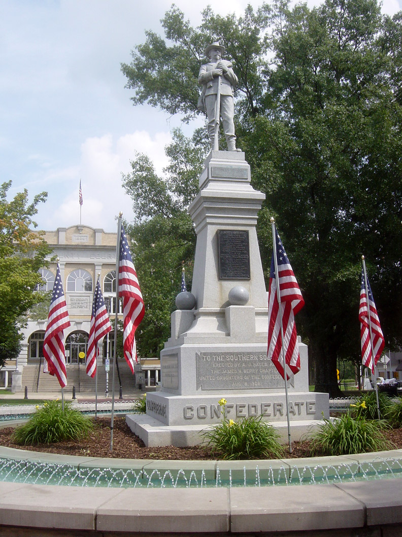
Bentonville Confederate Monument
Monument and historic site · National Register of Historic Places · 7.3 mi
Monument in Bentonville, United States of America

Bentonville West Central Avenue Historic District
Monument and historic site · National Register of Historic Places · 7.1 mi
Historic district in Bentonville, Arkansas

Bertschy House
Monument and historic site · National Register of Historic Places · 6.8 mi
Historic house in Arkansas, United States

Blackwell-Paisley Cabin
Monument and historic site · National Register of Historic Places · 3.1 mi
Historic house in Arkansas, United States
Bogan Cabin
Monument and historic site · National Register of Historic Places · 3.2 mi
Historic house in Arkansas, United States

Braithwaite House
Monument and historic site · National Register of Historic Places · 6.0 mi
Historic house in Arkansas, United States


Charles R. Craig Building
Monument and historic site · National Register of Historic Places · 7.4 mi
Historic building in Bentonville, Arkansas, US
26 more on the map.
Parks, trails and playgrounds55


BV Street Dept Trailhead
Hiking and trails · 2.3 mi
Parking at Trailhead or nearby Street Dept Building permitted
Mo-Su 05:00-22:00
Metfield Trailhead
Hiking and trails · 3.9 mi
Parking at Metfield for trail access is permitted
Mo-Su 05:00-22:00
Mulligan Trailhead
Hiking and trails · 4.1 mi
Parking at Clubhouse is permitted for trail access
Mo-Su 05:00-22:00
Scotsdale Overflow Trailhead
Hiking and trails · 2.3 mi
Parking in Scotsdale Overflow permitted
Mo-Su 05:00-22:00
43 more on the map.
Restaurants and cafes17


Top China
Restaurant · Chinese · 2.5 mi
32 Sugar Creek Center, Bella Vista
Tu-Th 11:00-21:30; Fr,Sa 11:00-22:00; Su 12:00-21:30


5 more on the map.
History
The area now encompassed by Bella Vista was used by groups of Osage and Delaware who utilized the area for seasonal hunting grounds. A prominent rock shelter known as Hay Bluff along US 71 was used by various groups in the area and remains an important archaeological site, before later being used by early settlers to store hay. The area was established as a primitive summer resort in 1909 by a Bentonville minister who envisioned golf, tennis, and inexpensive lots for summer cabins. In 1915, Lake Bella Vista was created by damming Little Sugar Creek. By 1916, the resort was sold to the Linebarger Brothers Realty Company, who further developed the resort to include more amenities, including the Sunset Hotel and Wonderland Cave nightclub. Early cabins recognized on the National Register of Historic Places include Blackwell-Paisley Cabin, Bogan Cabin, Hagler-Cole Cabin, Lamberton Cabin, Pharr Cabin, Princedom Cabin, and Sutherlin Cabin. The resort began catering to city dwellers with automobiles and came to include "colonies" of residents from Dallas, Texas and Tulsa, Oklahoma.
From the History section of Bella Vista, Arkansas on Wikipedia, under CC BY-SA 4.0.
Where to stay3
Churches and places of worship30
New Home School and Church
Church · National Register of Historic Places · 4.2 mi
Saint Bernard Catholic Church
Church · Roman Catholic · 1.7 mi
1 Saint Bernard Lane, Bella Vista
Bella Vista Baptist Church
Church · Baptist · 1.5 mi
50 East Lancashire Boulevard, Bella Vista
Bella Vista Lutheran Church
Church · Lutheran · 2.1 mi
1990 Forest Hills Boulevard, Bella Vista
Fellowship Baptist Church
Church · Baptist · 1.0 mi
502 West Lancashire Boulevard, Bella Vista
First United Methodist Church of Bella Vista
Church · Methodist · 0.6 mi
20 Boyce Drive, Bella Vista
Highland Hills United Methodist Church
Church · Methodist · 5.3 mi
371 Glasgow Road, Bella Vista
The Presbyterian Church of Bella Vista
Church · Presbyterian · 2.1 mi
1880 Forest Hills Boulevard, Bella Vista
Shopping7
Gas and EV charging8
Schools, colleges and libraries4
Healthcare7
Map of Bella Vista
173 places. The map loads OpenStreetMap tiles when you open it.
Climate by month
Monthly table
| Month | High | Low | Rain | Snow |
|---|---|---|---|---|
| Jan | 46°F | 24°F | 2.7 in | 3.2 in |
| Feb | 51°F | 27°F | 2.7 in | 2.3 in |
| Mar | 60°F | 36°F | 4.2 in | 2.6 in |
| Apr | 69°F | 44°F | 4.8 in | 0.0 in |
| May | 77°F | 54°F | 6.3 in | 0.0 in |
| Jun | 85°F | 63°F | 5.5 in | 0.0 in |
| Jul | 89°F | 66°F | 3.9 in | 0.0 in |
| Aug | 90°F | 65°F | 2.7 in | 0.0 in |
| Sep | 82°F | 57°F | 4.0 in | 0.0 in |
| Oct | 71°F | 46°F | 3.4 in | 0.0 in |
| Nov | 59°F | 36°F | 3.9 in | 0.2 in |
| Dec | 49°F | 27°F | 3.3 in | 1.2 in |
U.S. Climate Normals 1991-2020 for Bentonville 4 S (10 mi away), NOAA NCEI.
People and cost of living
American Community Survey 5-year estimates, 2020-2024, U.S. Census Bureau. Estimates have margins of error, larger for small towns.
Disaster history
Benton County has had 19 federal disaster declarations since 2000, most often for severe storms.
- 2026-01-24: Severe Winter Storm (Winter Storm)
- 2025-04-05: Severe Storms, Tornadoes, And Flooding (Severe Storm)
- 2024-05-30: Severe Storms, Straight-Line Winds, Tornadoes, And Flooding (Severe Storm)
- 2020-08-27: Hurricane Laura (Hurricane)
- 2020-04-03: Covid-19 Pandemic (Biological)
- 2020-03-13: Covid-19 (Biological)
OpenFEMA disaster declarations summaries.
Getting there and nearby towns
Rogers Executive Airport (ROG) is the nearest airport with scheduled flights listed in OpenStreetMap, 11 miles away.
- Gravette 6 mi southwest, about 10 min by car
- Bentonville 8 mi south, about 13 min by car
- Centerton 8 mi south, about 13 min by car
- Rogers 12 mi southeast, about 19 min by car
- Lowell 16 mi southeast, about 26 min by car
- Springdale 20 mi south, about 32 min by car
- Siloam Springs 24 mi southwest, about 39 min by car
- Fayetteville 28 mi south, about 45 min by car
- Miami 44 mi northwest, about 1 h 15 min by car
- Tahlequah 55 mi southwest, about 1 h 30 min by car
Drive times are estimates from straight-line distance, not routes.
Local news
Headlines from INDB, the NEMICO news database.
Reviews, tips and questions
Loading what members have shared...
Sources and licences
- NOAA NCEI U.S. Climate Normals 1991-2020 (Public domain): climate by month
- OpenFEMA (Public domain): disaster declarations
- OpenStreetMap contributors (ODbL 1.0): places, airports, map data
- U.S. Census Bureau (Public domain): population, income, housing, education, commute
- Wikidata (CC0 1.0): elevation, founding date, time zone, website, landmarks and historic places
- Wikimedia Commons (see each image): photos
- Wikipedia (CC BY-SA 4.0): overview and history text
Photo credits
- Bella Vista Water Tank, Valis55, CC BY-SA 3.0
- Bella Vista, AR - panoramio, Cal Wolfe, CC BY-SA 3.0
- Hotel Massey, Brandonrush, CC BY-SA 3.0
- Braithwaite House, Valis55, CC BY-SA 3.0
- Bertschy House, Valis55, CC BY-SA 3.0
- Craig-Bryan House, Brandonrush, CC BY-SA 3.0
- Craig-Bryan House, Bentonville, Alfredo Carrillo, CC BY 2.0
- 09-02-06-BentonvilleConfed-monument, Bobak Ha'Eri, CC BY 2.5
- Linebarger House, Bentonville, AR, Brandonrush, CC BY-SA 3.0
- Benton County Jail, Bentonville, AR, Brandonrush, CC BY-SA 3.0
- Benton County Poor Farm Cemetery, Valis55, CC BY-SA 3.0
- Terry Block Building, Brandonrush, CC BY-SA 3.0
- BLACKWELL-PAISLEY CABIN, BELLA VISTA, BENTON COUNTY, AR, JERRYE & ROY KLOTZ MD, CC BY-SA 4.0
- PHARR CABIN, BELLA VISTA, BENTON COUNTY, AR, JERRYE & ROY KLOTZ MD, CC BY-SA 4.0
- Charles R. Craig Building, Brandonrush, CC BY-SA 3.0
- Smith House, Bentonville, AR, Valis55, CC BY-SA 3.0
- COL. SAMUEL W. PEEL HOUSE, BENTONVILLE, BENTON COUNTY, AR, JERRYE & ROY KLOTZ MD, CC BY-SA 4.0
- SUTHERLIN CABIN, BELLA VISTA, BENTON COUNTY, AR, JERRYE & ROY KLOTZ MD, CC BY-SA 4.0
- Koons House, Valis55, CC BY-SA 3.0
- Jackson House, Bentonville, AR, Brandonrush, CC BY-SA 3.0
- ShadyGroveSchoolPeaRidgeAR, Melodibit, CC BY-SA 3.0
- Benton County National Bank, Brandonrush, CC BY-SA 3.0
- Maxwell-Hinman House, Valis55, CC BY-SA 3.0
- Benton County Courthouse, Bentonville, Arkansas, Brandonrush, CC BY-SA 3.0
- Macon-Harrison House, Valis55, CC BY-SA 3.0
- Bentonville High, Milesdap, CC BY-SA 3.0
- Rice House, Bentonville, AR, Valis55, CC BY-SA 3.0
- LAMBERTON CABIN, BELLA VISTA, BENTON COUNTY, AR, JERRYE & ROY KLOTZ MD, CC BY-SA 4.0
- Museum of Native American History, Ethan.jarrett, CC BY-SA 4.0
- Crystal Bridges Museum of American Art--2012-04-12, Charvex, CC0
- Mildred B Cooper Memorial Chapel inside, Flickr user: LearningLark, CC BY 2.0
- Bentonville Arkansas Temple 20230619 0927, Dmm1169, CC BY-SA 4.0
- Waterfall At Tanyard Creek, Doug Wertman, CC BY 2.0
- Mildred B. Cooper Memorial Chapel, EEJCC, CC BY-SA 4.0
- ISS053-E-299105 - View of Earth, Earth Science and Remote Sensing Unit , Lyndon B. Johnson Space Center, Public domain
- ISS053-E-299106 - View of Earth, Earth Science and Remote Sensing Unit , Lyndon B. Johnson Space Center, Public domain
- Deaton Cabin ( all that remains), Valis55, CC BY-SA 3.0
- Wonderland Cave, Valis55, CC BY-SA 3.0
- Princedom, Milesdap, CC BY-SA 3.0
- Hagler-Cole Cabin, Valis55, CC BY-SA 3.0


Page built October 30, 2026. Spotted a mistake? Tell us or suggest a place.