


Blue Ball, Pennsylvania
Blue Ball is a community of 1,284 people in Lancaster County, Pennsylvania.
Why visit Blue Ball
Townapedia lists 8 museums and landmarks, 3 parks and trails, 7 places to eat, 1 place to stay and 1 attraction in and around town.
Highlights include Weaverland Bridge, David Davis Farm and Henry Weaver Farmstead.
July is the warmest month, with average highs of 86°F; January lows average 24°F, and about 34 inches of snow fall in a normal year.
Weather in Blue Ball
Forecast from the National Weather Service. Full forecast
About Blue Ball
Blue Ball is an unincorporated community and census-designated place (CDP) in East Earl Township, Lancaster County, Pennsylvania, United States. Blue Ball lies approximately 2 miles (3 km) east-northeast of the borough of New Holland at the intersection of US 322 and PA Route 23. As of the 2020 census, the population was 1,095.
From the Wikipedia article Blue Ball, Pennsylvania (this version), under CC BY-SA 4.0.
Things to do1

Museums and landmarks8

David Davis Farm
Monument and historic site · National Register of Historic Places · 1.5 mi
New Holland, Pennsylvania, NRHP-listed in Lancaster County, Pennsylvania
Henry Weaver Farmstead
Monument and historic site · National Register of Historic Places · 1.6 mi
Building in Pennsylvania, United States

John Casper Stoever Log House
Monument and historic site · National Register of Historic Places · 2.1 mi
Historic house in Pennsylvania, United States
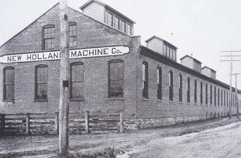
New Holland Machine Company
Monument and historic site · National Register of Historic Places · 1.9 mi
Building in New Holland, Pennsylvania, United States


Spring Grove Forge Mansion
Monument and historic site · National Register of Historic Places · 2.9 mi
Building in Pennsylvania, United States
Peter Martin Cabin
Monument and historic site · 1.5 mi
Located on the Big Spring Farm. Log cabin built ca. 1786. Cabin relocated to his farm in 2001. Cabin was home of the Mennonite Martin...
739 Spruce Road, New Holland
Parks, trails and playgrounds3


Restaurants and cafes7

Shady Maple Smorgasbord
Restaurant · American, Pizza, Burger, Italian, Chicken, Fish, Dessert, Salad, Ice Cream, Pasta, Cake, Buffet · 1.3 mi
129 Toddy Drive, East Earl
Mo-Sa 07:00-19:30

Fireside Cafe
Cafe · 1.3 mi
158 Toddy Drive, East Earl
Mo-Th 06:30-18:00; Fr 06:30-20:00; Sa 07:30-20:00; Su off
Yoder's Restaurant and Buffet
Restaurant · 0.6 mi
14 South Tower Road, New Holland
Mo-Th 06:00-19:00; Fr-Sa 06:00-20:00; Su 10:00-14:00
Carini's Italian Restaurant
Restaurant · Italian · 0.6 mi
4204 Division Highway, Blue Ball
10:00-21:00
Twin Valley Coffee
Cafe · 1.4 mi
1324 Main Street, East Earl
Mo-Fr 06:00-18:00; Sa 07:00-16:00; Su off

A Slice of Brooklyn
Fast food · Pizza · 0.5 mi
808 East Main Street, New Holland
Mo-Th,Su 11:00-21:00; Fr-Sa 11:00-22:00
Where to stay1
Churches and places of worship11
Lighthouse Church
Church · Assemblies Of God · 1.3 mi
1279 Main Street, East Earl
Shopping4
Gas and EV charging4
Schools, colleges and libraries7
Healthcare3
LG Health Physicians Family Medicine New Holland
Clinic and pharmacy · 0.7 mi
676 East Main Street, New Holland
Map of Blue Ball
49 places. The map loads OpenStreetMap tiles when you open it.
Climate by month
Monthly table
| Month | High | Low | Rain | Snow |
|---|---|---|---|---|
| Jan | 39°F | 24°F | 3.3 in | 10.3 in |
| Feb | 42°F | 25°F | 2.8 in | 10.6 in |
| Mar | 50°F | 32°F | 4.1 in | 5.5 in |
| Apr | 63°F | 42°F | 3.6 in | 1.2 in |
| May | 73°F | 53°F | 3.5 in | 0.0 in |
| Jun | 81°F | 62°F | 4.5 in | 0.0 in |
| Jul | 86°F | 66°F | 4.4 in | 0.0 in |
| Aug | 84°F | 65°F | 4.3 in | 0.0 in |
| Sep | 77°F | 58°F | 4.9 in | 0.0 in |
| Oct | 65°F | 47°F | 4.6 in | 0.3 in |
| Nov | 54°F | 36°F | 3.2 in | 1.0 in |
| Dec | 43°F | 29°F | 3.7 in | 4.6 in |
U.S. Climate Normals 1991-2020 for New Holland 2 Se (3 mi away), NOAA NCEI.
People and cost of living
American Community Survey 5-year estimates, 2020-2024, U.S. Census Bureau. Estimates have margins of error, larger for small towns.
Disaster history
Lancaster County has had 13 federal disaster declarations since 2000, most often for hurricanes.
- 2020-03-30: Covid-19 Pandemic (Biological)
- 2020-03-13: Covid-19 (Biological)
- 2016-03-23: Severe Winter Storm And Snowstorm (Snowstorm)
- 2014-02-06: Severe Winter Storm (Severe Ice Storm)
- 2012-10-29: Hurricane Sandy (Hurricane)
- 2011-09-12: Tropical Storm Lee (Flood)
OpenFEMA disaster declarations summaries.
Getting there and nearby towns
Lancaster Airport (LNS) is the nearest airport with scheduled flights listed in OpenStreetMap, 12 miles away.
- Ephrata 8 mi northwest, about 13 min by car
- Atglen 12 mi south, about 19 min by car
- Lancaster 14 mi west, about 22 min by car
- Coatesville 15 mi southeast, about 25 min by car
- Wyomissing 16 mi north, about 26 min by car
- Reading 17 mi northeast, about 28 min by car
- Pottstown 24 mi northeast, about 38 min by car
- Columbia 24 mi west, about 38 min by car
- Lebanon 25 mi northwest, about 40 min by car
- West Chester 26 mi southeast, about 42 min by car
Drive times are estimates from straight-line distance, not routes.
Local news
Headlines from INDB, the NEMICO news database.
Reviews, tips and questions
Loading what members have shared...
Sources and licences
- NCES EDGE (Public domain): public schools
- NOAA NCEI U.S. Climate Normals 1991-2020 (Public domain): climate by month
- OpenFEMA (Public domain): disaster declarations
- OpenStreetMap contributors (ODbL 1.0): places, airports, map data
- U.S. Census Bureau (Public domain): population, income, housing, education, commute
- Wikidata (CC0 1.0): landmarks and historic places
- Wikimedia Commons (see each image): photos
- Wikipedia (CC BY-SA 4.0): overview and history text
Photo credits
- 2007 09 18 - Blue Ball - US 322 at SR 23 a, Andrew Bossi, CC BY-SA 2.5
- PA 23 eb entering Blue Ball, June 2025, Mr. Matté (if there is an issue with this image, contact me using this image's Commons talk page , my Commons user talk page , or my English Wikipedia user talk page ; I'll know about it a lot faster), CC BY-SA 4.0
- Blue Ball, PA post office, June 2025, Mr. Matté (if there is an issue with this image, contact me using this image's Commons talk page , my Commons user talk page , or my English Wikipedia user talk page ; I'll know about it a lot faster), CC BY-SA 4.0
- US 322 wb west of Blue Ball, PA with 28th Division Highway shield, Dec. 2023, Mr. Matté (if there is an issue with this image, contact me using this image's Commons talk page , my Commons user talk page , or my English Wikipedia user talk page ; I'll know about it a lot faster), CC BY-SA 4.0
- 2007 09 18 - Blue Ball - US 322 at SR 23 b, Andrew Bossi, CC BY-SA 2.5
- 0902 - Blue Ball - SR23@US322, Andrew Bossi, CC BY-SA 2.5
- 0901 - Blue Ball - SR23@US322, Andrew Bossi, CC BY-SA 2.5
- 0900 - Blue Ball - SR23@US322, Andrew Bossi, CC BY-SA 2.5
- US 322 wb in Blue Ball, PA, Dec. 2023, Mr. Matté (if there is an issue with this image, contact me using this image's Commons talk page , my Commons user talk page , or my English Wikipedia user talk page ; I'll know about it a lot faster), CC BY-SA 4.0
- Blue Ball PA Keystone Marker on PA 23 WB, Dough4872, CC BY-SA 4.0
- PA 897 nb between Blue Ball and Terre Hill, Jan. 2025, Mr. Matté (if there is an issue with this image, contact me using this image's Commons talk page , my Commons user talk page , or my English Wikipedia user talk page ; I'll know about it a lot faster), CC BY-SA 4.0
- NH Pennsylvania e, newhollandag, CC BY-SA 2.0
- 200 W Main New Holland, Smallbones, CC BY-SA 3.0
- Spring Grove Forge Mansion, Smallbones, CC BY-SA 3.0
- Weaverland Bridge, Jet Lowe, Public domain
- PA 23 wb entering New Holland, July 2025, Mr. Matté (if there is an issue with this image, contact me using this image's Commons talk page , my Commons user talk page , or my English Wikipedia user talk page ; I'll know about it a lot faster), CC BY-SA 4.0
- US 322 WB past PA 23, Dough4872, CC BY-SA 4.0
- Garden Spot High School (PA) front, July 2025, Mr. Matté (if there is an issue with this image, contact me using this image's Commons talk page , my Commons user talk page , or my English Wikipedia user talk page ; I'll know about it a lot faster), CC BY-SA 4.0
- 0899 - Hinkletown - SR23@US322, Andrew Bossi, CC BY-SA 2.5
- East Earl Township, PA Municipal Building, June 2025, Mr. Matté (if there is an issue with this image, contact me using this image's Commons talk page , my Commons user talk page , or my English Wikipedia user talk page ; I'll know about it a lot faster), CC BY-SA 4.0
- East Earl Twp., Lancaster Co., PA municipal building (2), Dec. 2023, Mr. Matté (if there is an issue with this image, contact me using this image's Commons talk page , my Commons user talk page , or my English Wikipedia user talk page ; I'll know about it a lot faster), CC BY-SA 4.0
- PA 897 NB past PA 23, Dough4872, CC BY-SA 4.0
- East Earl Twp., Lancaster Co., PA municipal building (1), Dec. 2023, Mr. Matté (if there is an issue with this image, contact me using this image's Commons talk page , my Commons user talk page , or my English Wikipedia user talk page ; I'll know about it a lot faster), CC BY-SA 4.0
- New Holland, PA municipal building (2), June 2025, Mr. Matté (if there is an issue with this image, contact me using this image's Commons talk page , my Commons user talk page , or my English Wikipedia user talk page ; I'll know about it a lot faster), CC BY-SA 4.0
- New Holland, PA municipal building (1), June 2025, Mr. Matté (if there is an issue with this image, contact me using this image's Commons talk page , my Commons user talk page , or my English Wikipedia user talk page ; I'll know about it a lot faster), CC BY-SA 4.0
- Shady Maple Side, A.Classical-Futurist, CC BY 4.0
- Shady Maple Main Side, A.Classical-Futurist, CC BY 4.0
- Shady Maple Side 2, A.Classical-Futurist, CC BY 4.0
- Shady Maple dining room, FossilDS, CC0
- Shady Maple Carving, A.Classical-Futurist, CC BY 4.0
- Shady Maple Host Desk, A.Classical-Futurist, CC BY 4.0
- Shady Maple - panoramio, Bobby17543, CC BY-SA 3.0
- East Earl Township, PA, USA - panoramio, Bobby17543, CC BY-SA 3.0
- 737 Spruce LanCo Stone Barn, Smallbones, CC BY-SA 3.0
- 737 Spruce LanCo Wood Barn, Smallbones, CC BY-SA 3.0
- 737 Spruce LanCo graveyard, Smallbones, CC BY-SA 3.0
- 737 Spruce LanCo cabin, Smallbones, CC BY-SA 3.0
- 737 Spruce LanCo house, Smallbones, CC BY-SA 3.0


Page built October 30, 2026. Spotted a mistake? Tell us or suggest a place.