
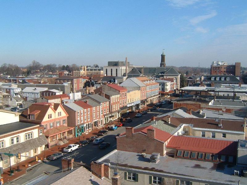


West Chester, Pennsylvania
West Chester is a borough of 20,666 people in Chester County, Pennsylvania, founded in March 28, 1799.
Why visit West Chester
Townapedia lists 55 museums and landmarks, 22 parks and trails, 123 places to eat, 4 places to stay and 6 attractions in and around town.
Highlights include Cope's Bridge, County Bridge No. 148, Chester County Courthouse and Farmers and Mechanics Building.
July is the warmest month, with average highs of 86°F; January lows average 20°F, and about 30 inches of snow fall in a normal year.
Weather in West Chester
Forecast from the National Weather Service. Full forecast
About West Chester
West Chester is a borough and the county seat of Chester County, Pennsylvania, United States. Located in the Philadelphia metropolitan area, the borough had a population of 18,671 at the 2020 census. West Chester is the mailing address for most of its neighboring townships.
From the Wikipedia article West Chester, Pennsylvania (this version), under CC BY-SA 4.0.
Things to do6

Cope's Bridge
Bridge · National Register of Historic Places · 2.6 mi
Bridge in United States of America
County Bridge No. 148
Bridge · National Register of Historic Places · 3.4 mi
Bridge in United States of America
Lenape Bridge
Bridge · National Register of Historic Places · 3.4 mi
Bridge in United States of America


West Chester University of Pennsylvania
School · 0.6 mi
Public university in southeastern Pennsylvania

Museums and landmarks55

Chester County Courthouse
Monument and historic site · National Register of Historic Places
Courthouse in Pennsylvania, United States
10 North High Street, West Chester


Farmers and Mechanics Building
Monument and historic site · National Register of Historic Places
Building in Pennsylvania, United States of America
Bank of Chester County
Monument and historic site · National Register of Historic Places
Building in Pennsylvania, United States
Barclay House
Monument and historic site · National Register of Historic Places · 0.5 mi
Historic house in West Chester, Pennsylvania, USA
Benjamin Rush House
Monument and historic site · National Register of Historic Places · 3.4 mi
Historic house in Pennsylvania, United States
Butler House
Monument and historic site · National Register of Historic Places · 0.8 mi
Listed on the NRHP in Pennsylvania
Carter-Worth House and Farm
Monument and historic site · National Register of Historic Places · 3.4 mi
Marshallton, Pennsylvania, NRHP-listed in Chester County
Col. John Hannum House
Monument and historic site · National Register of Historic Places · 2.9 mi
Historic house in Pennsylvania, United States
Collins Mansion
Monument and historic site · National Register of Historic Places · 1.0 mi
Building in Pennsylvania, United States
Daniel Davis House and Barn
Monument and historic site · National Register of Historic Places · 3.2 mi
Birmingham, Pennsylvania, NRHP-listed in southern Chester County, Pennsylvania
Daniel Meredith House
Monument and historic site · National Register of Historic Places · 3.1 mi
Historic house in Pennsylvania, United States
East Bradford Boarding School for Boys
Monument and historic site · National Register of Historic Places · 2.2 mi
Single-family detached home in Pennsylvania, United States of America
43 more on the map.
Parks, trails and playgrounds22

Stroud Preserve
Park · 2.3 mi
Nature reserve in Chester County, Pennsylvania

Tomlinson-Fillippo Field at Farrell Stadium
Sports field and stadium · 1.6 mi
855 South New Street, West Chester
Kathy McBratnie Park
Park · 0.6 mi
300 West Nields Street, West Chester
sunrise-sunset

Robert B. Gordon Natural Area for Environmental Studies
Hiking and trails · 1.5 mi
10 more on the map.
Restaurants and cafes123

Pietro’s Prime
Restaurant · Steak House
Masks must be worn except when seated. There is a two hour window for dining.
125 West Market Street, West Chester
Mo-Sa 11:00-21:00; Su 16:00-21:00
The Mediterranean Restaurant & Bakery
Restaurant · Lebanese, Italian
BYOB
150 West Gay Street, West Chester
Mo off; Tu-Su 15:00-21:00
Aldo's Restaurant & Grill
Restaurant · Greek · 1.1 mi
104 Turner Lane, West Chester
Mo-Sa 08:00-21:00; Su 08:00-20:00
America's Pie
Restaurant · Pizza · 0.4 mi
323 East Gay Street, West Chester
Mo off; Tu-Th,Su 11:00-20:00; Fr-Sa 11:00-21:00
Amore Pizza
Restaurant · Pizza
316 South High Street, West Chester
Mo-Th 10:00-21:30; Fr-Sa 10:00-23:00; Su 11:00-21:30
Andiaro
Restaurant
"We are generally open Wednesday-Saturday. Reservations for the following month become available to book online at noon on the 20th of...
106 West Gay Street, West Chester
Mo-Tu,Su off; We-Sa "by reservation"
Baan Thai Sabaidee
Restaurant · Thai · 0.9 mi
704 West Nields Street, West Chester
Mo-Th 11:30-21:00; Fr 11:30-21:30; Sa 14:00-21:30; Su off
Carmine's Pizzeria
Restaurant · Pizza · 1.2 mi
947 Paoli Pike, West Chester
Mo-Th,Su 10:00-21:00; Fr-Sa 10:00-22:00
D.P. Dough
Restaurant · Calzone
7 West Gay Street, West Chester
Mo-Th,Su 16:00-26:30; Fr-Sa 16:00-27:00

Dia Doce Cupcakes and Cathey’s Coffee Bar
Cafe · Cupcakes
100 South High Street, West Chester
Mo-Su 07:00-16:00
Fiorello Cafe
Restaurant · Italian · 0.8 mi
730 East Gay Street, West Chester
Mo-Fr 11:00-21:00; Sa 11:00-21:30; Su 12:30-21:00
111 more on the map.
History
The area was originally known as Turk's Head, named after the inn of the same name located in what is now the center of the borough. West Chester has been the seat of government in Chester County since 1786 when the seat was moved from nearby Chester in what is now Delaware County. The borough was incorporated in 1799.
In the center of town is its courthouse, a classical revival building designed in the 1840s by Thomas U. Walter, one of the architects for the Capitol in Washington, D.C. In the 18th century West Chester was a center of clockmaking. Irish revolutionary Theobald Wolfe Tone briefly lived in West Chester during his exile. In the late 19th century the Hoopes, Bro. and Darlington company became a major wheelworks, first for wagons and later automobiles. In the early 20th century, an important industry was the Sharples cream separator company. In the late 20th century, Commodore International, one of the pioneers of home computers, giving its headquarters as West Chester, was located approximately a mile northeast of the borough.
From the History section of West Chester, Pennsylvania on Wikipedia, under CC BY-SA 4.0.
Where to stay4
The Taylor Farmhouse Bed & Breakfast
Motel and hotel · 1.1 mi
100 Taylors Mill Road, West Goshen Township
Churches and places of worship25
First Presbyterian Church of West Chester
Church · Presbyterian Church Usa · National Register of Historic Places
130 West Miner Street, West Chester
Holy Ascension Antiochian Orthodox Church
Church · Antiochian Orthodox · 1.5 mi
558 Highland Road, East Bradford Township
Second United Presbyterian Church
Church · Presbyterian Church Usa
114 South Walnut Street, West Chester
The United Methodist Church of West Chester
Church · United Methodist
129 South High Street, West Chester
Shopping19
Gas and EV charging12
Schools, colleges and libraries32
Chester County Tech College Hs - Brandywine Campus
School · 5.1 mi
443 Boot Road, Downingtown
Healthcare9
Map of West Chester
250 places. The map loads OpenStreetMap tiles when you open it.
Climate by month
Monthly table
| Month | High | Low | Rain | Snow |
|---|---|---|---|---|
| Jan | 40°F | 20°F | 3.6 in | 7.9 in |
| Feb | 42°F | 21°F | 3.1 in | 13.2 in |
| Mar | 51°F | 29°F | 4.6 in | 4.1 in |
| Apr | 63°F | 38°F | 3.8 in | 0.4 in |
| May | 73°F | 49°F | 3.8 in | 0.0 in |
| Jun | 82°F | 59°F | 4.0 in | 0.0 in |
| Jul | 86°F | 64°F | 4.4 in | 0.0 in |
| Aug | 84°F | 62°F | 4.8 in | 0.0 in |
| Sep | 78°F | 54°F | 5.7 in | 0.0 in |
| Oct | 66°F | 41°F | 4.8 in | 0.0 in |
| Nov | 55°F | 32°F | 3.5 in | 0.5 in |
| Dec | 44°F | 25°F | 4.7 in | 4.4 in |
U.S. Climate Normals 1991-2020 for W Chester 2 Nw Hcn (2 mi away), NOAA NCEI.
People and cost of living
American Community Survey 5-year estimates, 2020-2024, U.S. Census Bureau. Estimates have margins of error, larger for small towns.
Disaster history
Chester County has had 17 federal disaster declarations since 2000, most often for hurricanes.
- 2021-09-10: Remnants Of Hurricane Ida (Hurricane)
- 2020-03-30: Covid-19 Pandemic (Biological)
- 2020-03-13: Covid-19 (Biological)
- 2016-03-23: Severe Winter Storm And Snowstorm (Snowstorm)
- 2014-02-06: Severe Winter Storm (Severe Ice Storm)
- 2012-10-29: Hurricane Sandy (Hurricane)
OpenFEMA disaster declarations summaries.
Getting there and nearby towns
Chester County G. O. Carlson Airport (CTH) is the nearest airport with scheduled flights listed in OpenStreetMap, 14 miles away.
- Coatesville 11 mi west, about 18 min by car
- Phoenixville 13 mi north, about 21 min by car
- Hockessin 13 mi south, about 21 min by car
- Broomall 13 mi east, about 21 min by car
- Chester 15 mi southeast, about 24 min by car
- King of Prussia 15 mi northeast, about 25 min by car
- Wilmington 16 mi south, about 26 min by car
- Drexel Hill 16 mi east, about 26 min by car
- Ardmore 17 mi east, about 27 min by car
- Pike Creek Valley 17 mi south, about 27 min by car
Drive times are estimates from straight-line distance, not routes.
Local news
Headlines from INDB, the NEMICO news database.
Reviews, tips and questions
Loading what members have shared...
Sources and licences
- NCES EDGE (Public domain): public schools
- NOAA NCEI U.S. Climate Normals 1991-2020 (Public domain): climate by month
- OpenFEMA (Public domain): disaster declarations
- OpenStreetMap contributors (ODbL 1.0): places, airports, map data
- U.S. Census Bureau (Public domain): population, income, housing, education, commute
- Wikidata (CC0 1.0): elevation, founding date, time zone, website, landmarks and historic places
- Wikimedia Commons (see each image): photos
- Wikipedia (CC BY-SA 4.0): overview and history text
Photo credits
- Westchester, Zoewscott, Public domain
- 2022-09-05 16 13 20 View east along U.S. Route 322 Business and Pennsylvania State Route 3 (Market Street) just west of High Street in West Chester, Chester County, Pennsylvania, Famartin, CC BY-SA 4.0
- 2022-09-08 14 14 54 View east along Pennsylvania State Route 3 (Market Street) just east of U.S. Route 322 Business (High Street) in West Chester, Chester County, Pennsylvania, Famartin, CC BY-SA 4.0
- Gay Street WB past Church Street West Chester, Dough4872, CC BY-SA 4.0
- 2022-09-05 09 18 02 View west along U.S. Route 322 Business (High Street) just east of Pennsylvania State Route 3 westbound (Chestnut Street) in West Chester, Chester County, Pennsylvania, Famartin, CC BY-SA 4.0
- 2022-09-08 11 04 20 View west along Pennsylvania State Route 842 (West Miner Street) just west of U.S. Route 322 Business (High Street) in West Chester, Chester County, Pennsylvania, Famartin, CC BY-SA 4.0
- 2022-09-08 09 35 12 View west along Pennsylvania State Route 3 (Chestnut Street) just west of Walnut Street in West Chester, Chester County, Pennsylvania, Famartin, CC BY-SA 4.0
- St. Agnes Parochial School (West Chester, Pennsylvania), WhisperToMe, CC0
- St. Agnes Catholic Church (West Chester, PA) 4, WhisperToMe, CC0
- St. Agnes Parochial School (West Chester, Pennsylvania) 4, WhisperToMe, CC0
- St. Agnes Parochial School (West Chester, Pennsylvania) 2, WhisperToMe, CC0
- St. Agnes Parochial School (West Chester, Pennsylvania) 3, WhisperToMe, CC0
- PA 3 wb at Walnut Street, West Chester, March 2025, Mr. Matté (if there is an issue with this image, contact me using this image's Commons talk page , my Commons user talk page , or my English Wikipedia user talk page ; I'll know about it a lot faster), CC BY-SA 4.0
- Krapf Transit ChescoBus 1910 at West Chester Transportation Center, Dough4872, CC BY-SA 4.0
- St. Agnes Catholic Church (West Chester, PA) 2, WhisperToMe, CC0
- United Methodist Church of West Chester, PA, March 2025, Mr. Matté (if there is an issue with this image, contact me using this image's Commons talk page , my Commons user talk page , or my English Wikipedia user talk page ; I'll know about it a lot faster), CC BY-SA 4.0
- First Presbyterian Church of West Chester (8562651654), Teemu008 from Palatine, Illinois, CC BY-SA 2.0
- St. Agnes Catholic Church (West Chester, PA) 3, WhisperToMe, CC0
- St. Agnes Catholic Church (West Chester, PA) 5, WhisperToMe, CC0
- St. Agnes Catholic Church (West Chester, PA), WhisperToMe, CC0
- 2022-09-05 16 09 05 View east along U.S. Route 322 Business (New Street) just west of Market Street in West Chester, Chester County, Pennsylvania, Famartin, CC BY-SA 4.0
- 2022-09-08 09 31 15 View west along Pennsylvania State Route 3 (Matlack Street) at Chestnut Street in West Chester, Chester County, Pennsylvania, Famartin, CC BY-SA 4.0
- 2022-09-08 09 31 58 View west along Pennsylvania State Route 3 (Chestnut Street) just west of Matlack Street in West Chester, Chester County, Pennsylvania, Famartin, CC BY-SA 4.0
- 2022-09-08 09 29 33 View west along Pennsylvania State Route 3 (Gay Street) just east of Matlack Street in West Chester, Chester County, Pennsylvania, Famartin, CC BY-SA 4.0
- 2022-09-05 09 20 04 View west along U.S. Route 322 Business (West Chestnut Street) just east of Hannum Avenue in West Chester, Chester County, Pennsylvania, Famartin, CC BY-SA 4.0
- West Chester Station 2018a, Ii2nmd at English Wikipedia, CC BY-SA 4.0
- West Chester Station 2018, Ii2nmd at English Wikipedia, CC BY-SA 4.0
- Original West Chester, PA PRR station and abandoned catenary, March 2025, Mr. Matté (if there is an issue with this image, contact me using this image's Commons talk page , my Commons user talk page , or my English Wikipedia user talk page ; I'll know about it a lot faster), CC BY-SA 4.0
- 1st Presbyterian Church West Chester PA, Smallbones, Public domain
- Farmers and Mechanics Building, Smallbones, Public domain
- Chester County PA Courthouse, Smallbones, Public domain
- 1st Nat Bank of WC PA 1912, Smallbones, Public domain
- Horticultural Hall WC PA, Smallbones, Public domain
- US 322 BUS EB approaching PA 3 EB, Dough4872, CC BY-SA 4.0
- Bank of Chester County (8560229739), Teemu008 from Palatine, Illinois, CC BY-SA 2.0
- NYBG varHorizontale 1852247, New York Botanical Garden Steere Herbarium (NY), CC BY 3.0
- Farmers and Mechanics Trust Company Building (8561337278), Teemu008 from Palatine, Illinois, CC BY-SA 2.0
- FnM WC PA, Smallbones, Public domain
- Warner Theater Panel, Smallbones, Public domain
- Warner Theater NRHP, Smallbones, Public domain


Page built October 30, 2026. Spotted a mistake? Tell us or suggest a place.