


Boronda, California
Boronda is a community of 1,351 people in Monterey County, California.
Why visit Boronda
Townapedia lists 14 museums and landmarks, 8 parks and trails, 37 places to eat and 8 places to stay in and around town.
Highlights include B. V. Sargent House, Boronda History Center, Central Park and Laurel Park.
September is the warmest month, with average highs of 75°F; December lows average 40°F.
Weather in Boronda
Forecast from the National Weather Service. Full forecast
About Boronda
Boronda is an unincorporated community and census-designated place (CDP) in Monterey County, California, United States. The population was 1,760 at the 2020 census. Boronda is located directly west of Salinas and is named after José Eusebio Boronda y Higuera, a Californio ranchero, and located on the lands of his Rancho Rincón del Sanjón.
From the Wikipedia article Boronda, California (this version), under CC BY-SA 4.0.
Museums and landmarks14

B. V. Sargent House
Monument and historic site · National Register of Historic Places · 1.5 mi
Historic house in California, United States


John Steinbeck House
Monument and historic site · National Register of Historic Places · 1.5 mi
Historic house in California, United States
Jose Eusebio Boronda Adobe
Monument and historic site · National Register of Historic Places · 0.5 mi
Historic house in California, United States

Krough House
Monument and historic site · National Register of Historic Places · 1.5 mi
One of four surviving examples of the Queen Anne houses that characterized Central Avenue in the 1890s.

Monterey County Court House
Monument and historic site · National Register of Historic Places · 1.7 mi
Courthouse in Salinas, United States of America

Monterey County Jail
Monument and historic site · National Register of Historic Places · 1.7 mi
Prison in California, United States of America

Republic Cafe
Monument and historic site · National Register of Historic Places · 1.7 mi
Asian restaurant and banquet hall in Salinas, California's Chinatown, in the United States
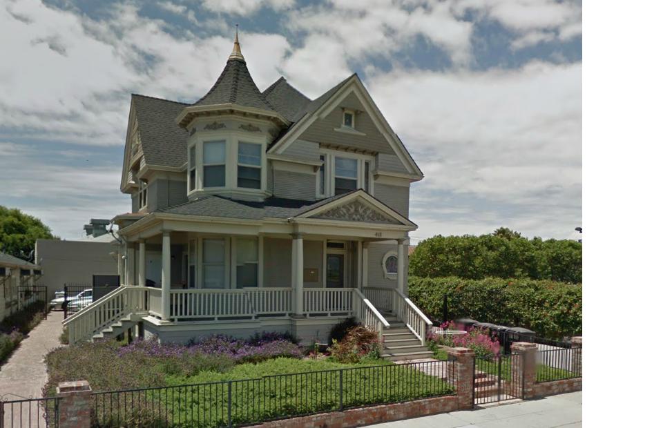
Samuel M. Black House
Monument and historic site · National Register of Historic Places · 2.1 mi
Historic building in California

Sheriff William Joseph Nesbitt House
Monument and historic site · National Register of Historic Places · 1.4 mi
Sheriff William Joseph Nesbitt House is a historic vernacular style house located at 66 Capitol St., Salinas, California.


National Steinbeck Center
Museum · 1.6 mi
Non-profit organization in the USA
2 more on the map.
Parks, trails and playgrounds8

Restaurants and cafes37


Salinas City Barbeque
Restaurant · Barbecue · 0.8 mi
700 West Market Street, Salinas
Mo-Sa 07:00-21:00; Su 11:00-20:00
Mountain Mike's Pizza
Restaurant · Pizza · 0.4 mi
1020 North Davis Road, Salinas
Mo-Su 11:00-22:00


IHOP
Restaurant · Breakfast, Pancake · 0.4 mi
1075 North Davis Road, Salinas
Mo-Su 06:00-22:00; Fr,Sa 06:00-24:00
25 more on the map.
Where to stay8

Laurel Inn and Conference Center
Motel and hotel · 0.7 mi
801 West Laurel Drive, Salinas
Churches and places of worship5
Shopping8
Gas and EV charging10
Schools, colleges and libraries51
Healthcare3
Map of Boronda
144 places. The map loads OpenStreetMap tiles when you open it.
Climate by month
Monthly table
| Month | High | Low | Rain | Snow |
|---|---|---|---|---|
| Jan | 63°F | 41°F | 3.3 in | 0.0 in |
| Feb | 64°F | 42°F | 3.0 in | 0.0 in |
| Mar | 66°F | 44°F | 2.5 in | 0.0 in |
| Apr | 67°F | 45°F | 1.1 in | 0.0 in |
| May | 68°F | 49°F | 0.5 in | 0.0 in |
| Jun | 70°F | 51°F | 0.1 in | 0.0 in |
| Jul | 71°F | 54°F | 0.0 in | 0.0 in |
| Aug | 72°F | 54°F | 0.0 in | 0.0 in |
| Sep | 75°F | 52°F | 0.1 in | 0.0 in |
| Oct | 74°F | 49°F | 0.6 in | 0.0 in |
| Nov | 68°F | 43°F | 1.6 in | 0.0 in |
| Dec | 62°F | 40°F | 2.8 in | 0.0 in |
U.S. Climate Normals 1991-2020 for Salinas #2 (2 mi away), NOAA NCEI.
People and cost of living
American Community Survey 5-year estimates, 2020-2024, U.S. Census Bureau. Estimates have margins of error, larger for small towns.
Disaster history
Monterey County has had 19 federal disaster declarations since 2000, most often for fires.
- 2024-04-13: Severe Winter Storms, Tornadoes, Flooding, Landslides, And Mudslides (Severe Storm)
- 2023-04-03: Severe Winter Storms, Straight-Line Winds, Flooding, Landslides, And Mudslides (Severe Storm)
- 2023-03-10: Severe Winter Storms, Flooding, Landslides, And Mudslides (Flood)
- 2023-01-14: Severe Winter Storms, Flooding, Landslides, And Mudslides (Flood)
- 2023-01-09: Severe Winter Storms, Flooding, And Mudslides (Flood)
- 2020-08-22: Wildfires (Fire)
OpenFEMA disaster declarations summaries.
Getting there and nearby towns
Salinas Municipal Airport (SNS) is the nearest airport with scheduled flights listed in OpenStreetMap, 4 miles away.
- Salinas 2 mi east, about 4 min by car
- Marina 6 mi west, about 10 min by car
- Castroville 7 mi northwest, about 11 min by car
- Prunedale 8 mi north, about 13 min by car
- Elkhorn 8 mi north, about 13 min by car
- Seaside 9 mi southwest, about 15 min by car
- Del Rey Oaks 11 mi southwest, about 18 min by car
- Las Lomas 12 mi north, about 20 min by car
- Monterey 13 mi southwest, about 21 min by car
- Aromas 13 mi north, about 21 min by car
Drive times are estimates from straight-line distance, not routes.
Local news
Headlines from INDB, the NEMICO news database.
Reviews, tips and questions
Loading what members have shared...
Sources and licences
- NCES EDGE (Public domain): public schools
- NOAA NCEI U.S. Climate Normals 1991-2020 (Public domain): climate by month
- OpenFEMA (Public domain): disaster declarations
- OpenStreetMap contributors (ODbL 1.0): places, airports, map data
- U.S. Census Bureau (Public domain): population, income, housing, education, commute
- Wikidata (CC0 1.0): elevation, founding date, time zone, website, landmarks and historic places
- Wikimedia Commons (see each image): photos
- Wikipedia (CC BY-SA 4.0): overview and history text
Photo credits
- Jose Eusebio Boronda Adobe Landmark, Greghenderson2006, CC BY-SA 4.0
- Boronda Adobe Saddle, 2020 IMG 6617v02, RGMendoza, CC BY-SA 4.0
- Boronda Adobe 008, Sgerbic, CC BY-SA 4.0
- Jose Eusebio Boronda Adobe 2012-09-25 11-44-35, TheJonesy, CC BY-SA 3.0
- Boronda Adobe 001, Sgerbic, CC BY-SA 4.0
- Boronda Adobe 002, Sgerbic, CC BY-SA 4.0
- Boronda Adobe 003, Sgerbic, CC BY-SA 4.0
- Boronda Adobe 007, Sgerbic, CC BY-SA 4.0
- Boronda Adobe 004, Sgerbic, CC BY-SA 4.0
- Boronda Adobe 005, Sgerbic, CC BY-SA 4.0
- Sheriff William Joseph Nesbitt House, McGhiever, CC BY-SA 3.0
- Monterey County Court House, Coasttocoast ( talk ), Public domain
- SteinbeckHouse, Original uploader was Googie man at en.wikipedia, CC BY-SA 3.0
- Fullsizeoutput 66b, Peter Robbert, CC BY-SA 4.0
- Monterey Co Jail, McGhiever, CC BY-SA 4.0
- Krough House 2013, McGhiever, CC BY-SA 3.0
- Samuel M. Black House 2, Rramosphoto, CC BY-SA 3.0
- NationalSteinbeckCentre, LordHarris at English Wikipedia, CC BY-SA 3.0
- Jensen Museum Building IMG 5293v02, RGMendoza, CC BY-SA 4.0
- Jo Mora working on California Carte, Lewis Josselyn, Public domain
- Jo Mora working on California Carte (back), Lewis Josselyn, Public domain
- Robinson Jeffers at Tor House, Lewis Josselyn, Public domain
- Monterey County Historical Society, Greghenderson2006, CC BY-SA 4.0
- Rancho Days Barbeque2 IMG 6121v02, RGMendoza, CC BY-SA 4.0
- Robinson Jeffers stands in front of his Hawk Tower, Lewis Josselyn, Public domain
- School tour group IMG 1283v02, RGMendoza, CC BY-SA 4.0
- Arvizu Family Descendant IMG 6040v02, RGMendoza, CC BY-SA 4.0
- World War II Bataan Monument Close, Abelp18, CC BY-SA 4.0
- William H. Weeks House, Greghenderson2006, CC BY-SA 4.0
- Lagunita Schoolhouse, Greghenderson2006, CC BY-SA 4.0
- Carmel Mission, viewed through tranquera, Lewis Josselyn, Public domain
- The majestic sky of Salinas Californi, Itcampy, CC BY-SA 3.0
- Eusebio Adobe, Intranila, CC BY-SA 3.0
- Filipino Farm Labor Bunkhouse IMG 5362vo2, RGMendoza, CC BY-SA 4.0
- Wax Paper Co Building IMG 5365v02, RGMendoza, CC BY-SA 4.0
- Amelia Gates Building by Lewis Josselyn, Lewis Josselyn, Public domain
- Carmel Weavers Studio with Ruth Kuster (back), Lewis Josselyn, Public domain
- Carmel Weavers Studio with Ruth Kuster, Lewis Josselyn, Public domain
- AlisalJail, Abelp18, CC BY-SA 4.0
- Theatre of the Golden Bough on Ocean Avenue, Lewis Josselyn, Public domain


Page built October 30, 2026. Spotted a mistake? Tell us or suggest a place.