



Why visit Salinas
Townapedia lists 16 museums and landmarks, 44 parks and trails, 171 places to eat, 19 places to stay and 4 attractions in and around town.
Highlights include TheFoxTheaterSalinas, ARIEL Theatrical, Inc., National Steinbeck Center and B. V. Sargent House.
September is the warmest month, with average highs of 74°F; December lows average 41°F.
Weather in Salinas
Forecast from the National Weather Service. Full forecast
About Salinas
Salinas (; Spanish for "Salt Flats") is a city in and the county seat of Monterey County, California, United States. With a population of 163,542 in the 2020 Census, Salinas is the most populous city in Monterey County. Salinas is an urban area located along the eastern limits of the Monterey Bay Area, lying just south of the San Francisco Bay Area and 10 miles (16 km) southeast of the mouth of the Salinas River. The city is located at the mouth of the Salinas Valley, about eight miles (13 km) from the Pacific Ocean, and it has a climate more influenced by the ocean than the interior.
From the Wikipedia article Salinas, California (this version), under CC BY-SA 4.0.
Things to do4

Museums and landmarks16

National Steinbeck Center
Museum · 1.5 mi
Non-profit organization in the USA
1 Main Street, Salinas
We-Sa 10:00-17:00; PH off

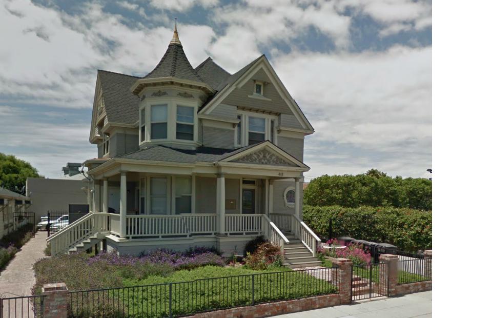
B. V. Sargent House
Monument and historic site · National Register of Historic Places · 1.7 mi
Historic house in California, United States


John Steinbeck House
Monument and historic site · National Register of Historic Places · 1.6 mi
Historic house in California, United States

Jose Eusebio Boronda Adobe
Monument and historic site · National Register of Historic Places · 2.6 mi
Historic house in California, United States
Krough House
Monument and historic site · National Register of Historic Places · 1.7 mi
One of four surviving examples of the Queen Anne houses that characterized Central Avenue in the 1890s.

Monterey County Court House
Monument and historic site · National Register of Historic Places · 1.7 mi
Courthouse in Salinas, United States of America

Monterey County Jail
Monument and historic site · National Register of Historic Places · 1.8 mi
Prison in California, United States of America
Rancho Las Palmas
Monument and historic site · National Register of Historic Places · 5.2 mi
Historic Queen Anne style house located at 100 River Road, Salinas, California, USA.

Republic Cafe
Monument and historic site · National Register of Historic Places · 1.3 mi
Asian restaurant and banquet hall in Salinas, California's Chinatown, in the United States
Samuel M. Black House
Monument and historic site · National Register of Historic Places · 1.6 mi
Historic building in California


Sheriff William Joseph Nesbitt House
Monument and historic site · National Register of Historic Places · 1.8 mi
Sheriff William Joseph Nesbitt House is a historic vernacular style house located at 66 Capitol St., Salinas, California.
4 more on the map.
Parks, trails and playgrounds44

32 more on the map.
Restaurants and cafes171

BJ's
Diner · American · 2.2 mi
1730 North Main Street, Salinas
Mo-Th 11:00-23:00; Fr-Sa 11:00-24:00; Su 10:00-23:00


Eagle Restaurant
Restaurant · Chinese · 1.7 mi
26 West Alisal Street, Salinas
Mo off; Tu-Su 11:00-20:30

Main Street Treats
Cafe · Frozen Yogurt · 1.5 mi
145 Main Street, Salinas
Su-Tu 11:00-21:00; Fr-Sa 11:00-23:00
Salinas City Barbeque
Restaurant · Barbecue · 2.1 mi
700 West Market Street, Salinas
Mo-Sa 07:00-21:00; Su 11:00-20:00

Alvarado Street Brewery & Taproom
Brewery and winery · 2.9 mi
1315 Dayton Street, Salinas
We-Fr 15:30-20:00; Sa 13:30-20:00; Su 12:30-17:00
159 more on the map.
History
The land on which Salinas is situated is thought to have been settled by Native Americans known as the Esselen prior to 200 AD. Between 200 and 500 AD, they were displaced by the Rumsen group of Ohlone speaking people. The Rumsen-Ohlone remained as the inhabitants of the area for approximately another 1,200 years, and in the 1700s, were the group of native inhabitants contacted and recorded by the first Spanish explorers of the Salinas area.
Upon the arrival of the Spanish, large Spanish land grants were initially issued for the Catholic Missions and also as bonuses to soldiers. Later on after Mexican independence, smaller land grants continued to be issued for ranchos where mostly cattle were grazed. One of the many land grants was the Rancho Las Salinas land grant, part of which included the area of modern-day Salinas. As a result of the many new cattle ranches, a thriving trade eventually developed in cattle hide shipments, shipping primarily out of the Port of Monterey.
Before the transition to American administration, Monterey had been the capital of California. For a short while after the transition, California was ruled by martial law. On September 9, 1850, California was admitted to the Union and became a State, celebrated as California Admission Day.
From the History section of Salinas, California on Wikipedia, under CC BY-SA 4.0.
Where to stay19
Holiday Inn Express Hotel & Suites Salinas
Motel and hotel · 0.7 mi
195 Kern Street, Salinas
Best Western Salinas Valley Inn & Suites
Motel and hotel · 0.7 mi
187 Kern Street, Salinas
Churches and places of worship21
The Church of Jesus Christ of Latter-day Saints
Church · Mormon · 1.4 mi
255 East Alvin Drive, Salinas
Shopping34
Gas and EV charging41
Schools, colleges and libraries105
Healthcare14
Central Coast Allergy & Asthma
Clinic and pharmacy · 2.5 mi
45 East San Joaquin Street, Salinas
Map of Salinas
250 places. The map loads OpenStreetMap tiles when you open it.
Climate by month
Monthly table
| Month | High | Low | Rain |
|---|---|---|---|
| Jan | 62°F | 42°F | 2.6 in |
| Feb | 63°F | 43°F | 2.4 in |
| Mar | 66°F | 44°F | 2.1 in |
| Apr | 67°F | 46°F | 0.9 in |
| May | 68°F | 50°F | 0.4 in |
| Jun | 70°F | 53°F | 0.1 in |
| Jul | 71°F | 55°F | 0.0 in |
| Aug | 72°F | 56°F | 0.0 in |
| Sep | 74°F | 54°F | 0.1 in |
| Oct | 74°F | 50°F | 0.6 in |
| Nov | 68°F | 44°F | 1.3 in |
| Dec | 62°F | 41°F | 2.1 in |
U.S. Climate Normals 1991-2020 for Salinas Municipal Ap 72593 (2 mi away), NOAA NCEI.
People and cost of living
American Community Survey 5-year estimates, 2020-2024, U.S. Census Bureau. Estimates have margins of error, larger for small towns.
Disaster history
Monterey County has had 19 federal disaster declarations since 2000, most often for fires.
- 2024-04-13: Severe Winter Storms, Tornadoes, Flooding, Landslides, And Mudslides (Severe Storm)
- 2023-04-03: Severe Winter Storms, Straight-Line Winds, Flooding, Landslides, And Mudslides (Severe Storm)
- 2023-03-10: Severe Winter Storms, Flooding, Landslides, And Mudslides (Flood)
- 2023-01-14: Severe Winter Storms, Flooding, Landslides, And Mudslides (Flood)
- 2023-01-09: Severe Winter Storms, Flooding, And Mudslides (Flood)
- 2020-08-22: Wildfires (Fire)
OpenFEMA disaster declarations summaries.
Getting there and nearby towns
Salinas Municipal Airport (SNS) is the nearest airport with scheduled flights listed in OpenStreetMap, 2 miles away.
- Boronda 2 mi west, about 4 min by car
- Castroville 8 mi northwest, about 14 min by car
- Marina 9 mi west, about 14 min by car
- Prunedale 9 mi north, about 14 min by car
- Elkhorn 10 mi northwest, about 15 min by car
- Seaside 11 mi southwest, about 18 min by car
- San Juan Bautista 12 mi northeast, about 19 min by car
- Aromas 13 mi north, about 21 min by car
- Las Lomas 13 mi northwest, about 22 min by car
- Monterey 15 mi southwest, about 24 min by car
Drive times are estimates from straight-line distance, not routes.
Local news
Headlines from INDB, the NEMICO news database.
Reviews, tips and questions
Loading what members have shared...
Sources and licences
- NCES EDGE (Public domain): public schools
- NOAA NCEI U.S. Climate Normals 1991-2020 (Public domain): climate by month
- OpenFEMA (Public domain): disaster declarations
- OpenStreetMap contributors (ODbL 1.0): places, airports, map data
- U.S. Census Bureau (Public domain): population, income, housing, education, commute
- Wikidata (CC0 1.0): elevation, founding date, time zone, website, landmarks and historic places
- Wikimedia Commons (see each image): photos
- Wikipedia (CC BY-SA 4.0): overview and history text
Photo credits
- Downtown Salinas, BrendelSignature at English Wikipedia, CC BY-SA 3.0
- From a Mexican grocer in Salinas (21364912798), Robert Ashworth from Bellingham, WA., USA, CC BY 2.0
- NationalSteinbeckCentre, LordHarris at English Wikipedia, CC BY-SA 3.0
- Krough House 2013, McGhiever, CC BY-SA 3.0
- Samuel M. Black House 2, Rramosphoto, CC BY-SA 3.0
- Eusebio Adobe, Intranila, CC BY-SA 3.0
- Sheriff William Joseph Nesbitt House, McGhiever, CC BY-SA 3.0
- Monterey County Court House, Coasttocoast ( talk ), Public domain
- SteinbeckHouse, Original uploader was Googie man at en.wikipedia, CC BY-SA 3.0
- Fullsizeoutput 66b, Peter Robbert, CC BY-SA 4.0
- Monterey Co Jail, McGhiever, CC BY-SA 4.0
- Coast Starlight train requires bikes to be boxed, but Amtrak Cascades doesn't require a box (21526104166), Robert Ashworth from Bellingham, WA., USA, CC BY 2.0
- Bike box for Amtrak (21526108696), Robert Ashworth from Bellingham, WA., USA, CC BY 2.0
- Mapillary (1376216349519313, o96r9fqu7t9ceib90ockj6 v00) (xponce25) 2020-03-31 19H40M45S584, xponce25, CC BY-SA 4.0
- Mapillary (713615136435969, o96r9fqu7t9ceib90ockj6 v00) (xponce25) 2020-03-31 19H40M41S650, xponce25, CC BY-SA 4.0
- Mapillary (1159885961496923, o96r9fqu7t9ceib90ockj6 v00) (xponce25) 2020-03-31 19H40M37S677, xponce25, CC BY-SA 4.0
- Mapillary (5419064674783948, o96r9fqu7t9ceib90ockj6 v00) (xponce25) 2020-03-31 19H40M35S550, xponce25, CC BY-SA 4.0
- Mapillary (339257541513057, o96r9fqu7t9ceib90ockj6 v00) (xponce25) 2020-03-31 19H40M34S646, xponce25, CC BY-SA 4.0
- Mapillary (1734621673559112, o96r9fqu7t9ceib90ockj6 v00) (xponce25) 2020-03-31 19H40M33S713, xponce25, CC BY-SA 4.0
- Mapillary (1429491034133600, o96r9fqu7t9ceib90ockj6 v00) (xponce25) 2020-03-31 19H40M32S622, xponce25, CC BY-SA 4.0
- Mapillary (498729305060548, o96r9fqu7t9ceib90ockj6 v00) (xponce25) 2020-03-31 19H40M31S726, xponce25, CC BY-SA 4.0
- Mapillary (312838657469819, o96r9fqu7t9ceib90ockj6 v00) (xponce25) 2020-03-31 19H40M30S554, xponce25, CC BY-SA 4.0
- Mapillary (242856831331755, o96r9fqu7t9ceib90ockj6 v00) (xponce25) 2020-03-31 19H40M29S625, xponce25, CC BY-SA 4.0
- Mapillary (1385334845238403, o96r9fqu7t9ceib90ockj6 v00) (xponce25) 2020-03-31 19H40M27S526, xponce25, CC BY-SA 4.0
- Mapillary (1022286812006248, o96r9fqu7t9ceib90ockj6 v00) (xponce25) 2020-03-31 19H40M26S660, xponce25, CC BY-SA 4.0
- Mapillary (989594035018634, o96r9fqu7t9ceib90ockj6 v00) (xponce25) 2020-03-31 19H40M25S526, xponce25, CC BY-SA 4.0
- Mapillary (734499887900923, o96r9fqu7t9ceib90ockj6 v00) (xponce25) 2020-03-31 19H40M24S628, xponce25, CC BY-SA 4.0
- Mapillary (511949697302093, o96r9fqu7t9ceib90ockj6 v00) (xponce25) 2020-03-31 19H40M23S497, xponce25, CC BY-SA 4.0
- Mapillary (706450040394935, o96r9fqu7t9ceib90ockj6 v00) (xponce25) 2020-03-31 19H40M22S614, xponce25, CC BY-SA 4.0
- Mapillary (345706697592509, o96r9fqu7t9ceib90ockj6 v00) (xponce25) 2020-03-31 19H40M21S707, xponce25, CC BY-SA 4.0
- Mapillary (455090659723598, o96r9fqu7t9ceib90ockj6 v00) (xponce25) 2020-03-31 19H40M19S622, xponce25, CC BY-SA 4.0
- Mapillary (737790460715544, o96r9fqu7t9ceib90ockj6 v00) (xponce25) 2020-03-31 19H38M09S702, xponce25, CC BY-SA 4.0
- Mapillary (1122607678582971, o96r9fqu7t9ceib90ockj6 v00) (xponce25) 2020-03-31 19H38M11S538, xponce25, CC BY-SA 4.0
- Mapillary (1373746296475867, o96r9fqu7t9ceib90ockj6 v00) (xponce25) 2020-03-31 19H37M51S531, xponce25, CC BY-SA 4.0
- Mapillary (745048363215224, o96r9fqu7t9ceib90ockj6 v00) (xponce25) 2020-03-31 19H40M15S654, xponce25, CC BY-SA 4.0
- Mapillary (3171824726428078, o96r9fqu7t9ceib90ockj6 v00) (xponce25) 2020-03-31 19H38M12S661, xponce25, CC BY-SA 4.0
- Mapillary (460669032521110, o96r9fqu7t9ceib90ockj6 v00) (xponce25) 2020-03-31 19H40M11S503, xponce25, CC BY-SA 4.0
- Mapillary (3284474678506446, o96r9fqu7t9ceib90ockj6 v00) (xponce25) 2020-03-31 19H37M48S513, xponce25, CC BY-SA 4.0
- Mapillary (958071931573640, o96r9fqu7t9ceib90ockj6 v00) (xponce25) 2020-03-31 19H38M13S525, xponce25, CC BY-SA 4.0
- Mapillary (958424144866560, o96r9fqu7t9ceib90ockj6 v00) (xponce25) 2020-03-31 19H40M05S669, xponce25, CC BY-SA 4.0


Page built October 30, 2026. Spotted a mistake? Tell us or suggest a place.