


Brandywine, Maryland
Brandywine is a community of 12,160 people in Prince George's County, Maryland.
Why visit Brandywine
Townapedia lists 4 museums and landmarks, 9 parks and trails, 35 places to eat, 6 places to stay and 1 attraction in and around town.
Highlights include Xscape 14, Early Family Historic District, Surratt House & Tavern and Brandywine Area Recreation Area.
July is the warmest month, with average highs of 88°F; January lows average 27°F.
Weather in Brandywine
Forecast from the National Weather Service. Full forecast
About Brandywine
Brandywine is the name of an unincorporated area in Prince George's County, Maryland, United States, that refers both to a census-designated place (CDP) and a zip code area which is much larger (20613), whose areas overlap. The population of Brandywine at the 2020 U.S. census was 10,550 for the CDP, and the population of ZIP code 20613 was 11,860 in 2010.
From the Wikipedia article Brandywine, Maryland (this version), under CC BY-SA 4.0.
Things to do1

Museums and landmarks4

Early Family Historic District
Monument and historic site · National Register of Historic Places · 2.2 mi
Historic district in Maryland, United States
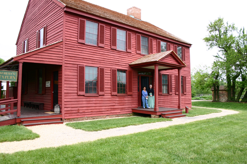
Surratt House & Tavern
Monument and historic site · National Register of Historic Places · 5.7 mi
Historic house museum in Clinton, Maryland, United States

William W. Early House
Monument and historic site · National Register of Historic Places · 2.2 mi
Historic house in Maryland, United States


Wyoming
Monument and historic site · National Register of Historic Places · 3.6 mi
Frame historic house located in Clinton in Prince George's County, Maryland, United States
Parks, trails and playgrounds9



Restaurants and cafes35


Chevys
Restaurant · Mexican · 0.9 mi
15914 Robert Crain Highway Southeast, Brandywine



Gemeny Winery and Vineyards
Brewery and winery · 2.0 mi
8606 Cedarville Road, Brandywine
23 more on the map.
History
William H. Early named the town of Brandywine as property he owned in the mid-19th century. The CDP consists of the property he owned in the 19th century. It is thought to be named after the Battle of Brandywine of the American Revolutionary War. Brandywine was developed on the Baltimore and Potomac Railroad's Pope Creek (Southern Maryland) line in about 1873 and was the only town on the route that developed into a railroad town.
On September 1, 1877, around 4 p.m., a small 2.7 magnitude earthquake struck Brandywine.
In 1912, the Bank of Brandywine was chartered from what had previously been the Southern Maryland German-American Bank.
Although located between the substantial bedroom cities of Clinton and Waldorf, Brandywine remained rural until after the turn of the twenty-first century, when shopping centers—including big-box stores—and small residential developments were built. Despite the building of both a major highway overpass and a roundabout in 2019, the community is still notorious for traffic slowdowns due to both daily local commuters and interstate travelers. As of 2024, two new townhouse developments are under construction.
From the History section of Brandywine, Maryland on Wikipedia, under CC BY-SA 4.0.
Where to stay6
Churches and places of worship10
Chapel of the Incarnation
Church · Episcopal · National Register of Historic Places · 2.0 mi
14070 Brandywine Road, Brandywine
Union Bethel AME Church
Church · African Methodist Episcopal · 1.7 mi
8610 Floral Park Road, Brandywine
Shopping5
Gas and EV charging10
Schools, colleges and libraries25
C. Paul Barnhart Elementary School
School · 5.0 mi
4800 Lancaster Circle, Waldorf
Daniel of St. Thomas Jenifer Elementary School
School · 4.1 mi
2820 Jenifer School Ln, Waldorf
Healthcare2
Map of Brandywine
107 places. The map loads OpenStreetMap tiles when you open it.
Climate by month
Monthly table
| Month | High | Low | Rain |
|---|---|---|---|
| Jan | 44°F | 27°F | 3.1 in |
| Feb | 48°F | 28°F | 2.9 in |
| Mar | 56°F | 35°F | 4.0 in |
| Apr | 67°F | 45°F | 3.4 in |
| May | 76°F | 55°F | 4.5 in |
| Jun | 84°F | 64°F | 4.8 in |
| Jul | 88°F | 69°F | 5.0 in |
| Aug | 86°F | 67°F | 4.2 in |
| Sep | 80°F | 60°F | 4.4 in |
| Oct | 68°F | 48°F | 3.8 in |
| Nov | 57°F | 38°F | 3.1 in |
| Dec | 48°F | 31°F | 3.8 in |
U.S. Climate Normals 1991-2020 for Oxon Hill (10 mi away), NOAA NCEI.
People and cost of living
American Community Survey 5-year estimates, 2020-2024, U.S. Census Bureau. Estimates have margins of error, larger for small towns.
Disaster history
Prince George's County has had 13 federal disaster declarations since 2000, most often for hurricanes.
- 2026-01-24: Severe Winter Storm (Winter Storm)
- 2020-03-26: Covid-19 Pandemic (Biological)
- 2020-03-13: Covid-19 (Biological)
- 2016-03-04: Severe Winter Storm And Snowstorm (Snowstorm)
- 2012-11-20: Hurricane Sandy (Hurricane)
- 2012-10-28: Hurricane Sandy (Hurricane)
OpenFEMA disaster declarations summaries.
Getting there and nearby towns
Joint Base Andrews (ADW) is the nearest airport with scheduled flights listed in OpenStreetMap, 9 miles away.
- Accokeek 6 mi west, about 10 min by car
- Bensville 8 mi southwest, about 13 min by car
- Alexandria 14 mi northwest, about 23 min by car
- Washington 17 mi northwest, about 27 min by car
- Arlington 18 mi northwest, about 29 min by car
- Bowie 20 mi northeast, about 33 min by car
- Adelphi 22 mi north, about 36 min by car
- Bethesda 25 mi northwest, about 39 min by car
- Beltsville 25 mi north, about 40 min by car
- Annapolis 29 mi northeast, about 46 min by car
Drive times are estimates from straight-line distance, not routes.
Local news
Headlines from INDB, the NEMICO news database.
Reviews, tips and questions
Loading what members have shared...
Sources and licences
- NCES EDGE (Public domain): public schools
- NOAA NCEI U.S. Climate Normals 1991-2020 (Public domain): climate by month
- OpenFEMA (Public domain): disaster declarations
- OpenStreetMap contributors (ODbL 1.0): places, airports, map data
- U.S. Census Bureau (Public domain): population, income, housing, education, commute
- Wikidata (CC0 1.0): elevation, founding date, time zone, website, landmarks and historic places
- Wikimedia Commons (see each image): photos
- Wikipedia (CC BY-SA 4.0): overview and history text
Photo credits
- 2016-09-09 09 54 59 View south along U.S. Route 301 and Maryland State Route 5 (Crain Highway) between Branch Avenue and Matapeake Business Drive in Brandywine, Prince Georges County, Maryland, Famartin, CC BY-SA 4.0
- 2019-08-23 11 12 34 View north along U.S. Route 301 and Maryland State Route 5 (Robert Crain Highway) at the exit for Maryland State Route 5 NORTH (Washington) in Brandywine, Prince George's County..., Famartin, CC BY-SA 4.0
- 2019-10-10 10 37 45 View south along Maryland State Route 5 (Branch Avenue) from the overpass for U.S. Route 301 southbound (Crain Highway) in Brandywine, Prince George's County, Maryland, Famartin, CC BY-SA 4.0
- 2019-10-10 10 38 38 View north along Maryland State Route 5 (Branch Avenue) from the overpass for U.S. Route 301 southbound (Crain Highway) in Brandywine, Prince George's County, Maryland, Famartin, CC BY-SA 4.0
- 2016-09-07 09 02 57 View north from the south end of Maryland State Route 631 (Old Brandywine Road) in Brandywine, Prince George's County, Maryland, Famartin, CC BY-SA 4.0
- 2019-10-01 12 11 25 View north along Maryland State Route 5 (Branch Avenue) at the exit for Brandywine Road (TO Maryland State Route 373-Accokeek Road) in Brandywine, Prince George's County, Maryland, Famartin, CC BY-SA 4.0
- 2020-06-19 10 50 02 View west along Maryland State Route 373 (Accokeek Road) at Maryland State Route 5 (Branch Avenue) in Brandywine, Prince George's County, Maryland, Famartin, CC BY-SA 4.0
- 2016-09-07 10 53 50 View west along Maryland State Route 373 (Accokeek Road) at Maryland State Route 5 (Branch Avenue) in Brandywine, Prince Georges County, Maryland, Famartin, CC BY-SA 4.0
- 2016-09-07 09 01 37 View south along Maryland State Route 631 (Old Brandywine Road) at Brandywine Road in Brandywine, Prince Georges County, Maryland, Famartin, CC BY-SA 4.0
- 2006 09 12 - Brandywine Rd west of 5, WB, Andrew Bossi, CC BY-SA 2.5
- 2016-09-10 11 17 17 View north along Maryland State Route 5 (Branch Avenue) at Brandywine Road in Brandywine, Prince Georges County, Maryland, Famartin, CC BY-SA 4.0
- 2019-08-23 08 57 47 View south along U.S. Route 301 and Maryland State Route 5 (Robert Crain Highway) at the exit for Maryland State Route 5 SOUTH (Lexington Park, Leonardtown) on the edge of..., Famartin, CC BY-SA 4.0
- 2019-10-10 10 50 38 View south along Maryland State Route 5 (Branch Avenue) from the overpass for Spine Road in Brandywine, Prince George's County, Maryland, Famartin, CC BY-SA 4.0
- 2019-10-10 10 51 07 View north along Maryland State Route 5 (Branch Avenue) from the overpass for Spine Road in Brandywine, Prince George's County, Maryland, Famartin, CC BY-SA 4.0
- 2019-10-02 15 55 16 View south along Maryland State Route 5 (Branch Avenue) at the exit for Brandywine Road (TO Maryland State Route 373-Accokeek Road) in Brandywine, Prince George's County, Maryland, Famartin, CC BY-SA 4.0
- Chapel of the Incarnation Dec 08, Pubdog at en.wikipedia, Public domain
- Wyoming Clinton MD 1936, John O. Brostrup, Photographer, Public domain
- Early House Dec 08, Pubdog ( talk ), Public domain
- SurrattHouse, Hawkeye58, CC BY-SA 3.0
- 2006 02 03 - 5-301@ShortCut - Northbound US301-MD5, Andrew Bossi, CC BY-SA 2.5
- 2006 10 23 - 5-301@ShortCut - Southbound US301-MD5, Andrew Bossi, CC BY-SA 2.5
- 2006 10 23 - 5-301@ShortCut - Northbound US301-MD5, Andrew Bossi, CC BY-SA 2.5
- ISS035-E-41207 - View of Earth, Earth Science and Remote Sensing Unit , Lyndon B. Johnson Space Center, Public domain
- ISS030-E-33989 - View of New Jersey, Earth Science and Remote Sensing Unit , Lyndon B. Johnson Space Center, Public domain
- 2006 08 21 - 301@CharlesCoLine - SB 2, Andrew Bossi, CC BY-SA 2.5
- 2006 08 21 - 301@CharlesCoLine - SB 1, Andrew Bossi, CC BY-SA 2.5
- 2016-08-28 14 42 21 View south along U.S. Route 301 (Crain Highway) at Mattawoman Drive in Waldorf, Charles County, Maryland, Famartin, CC BY-SA 4.0
- 2016-08-28 14 33 34 View south along Maryland State Route 5 (Mattawoman-Beantown Road) at Mattawoman Drive in Waldorf, Charles County, Maryland, Famartin, CC BY-SA 4.0
- 2019-08-23 11 01 28 View north along U.S. Route 301 (Robert Crain Highway) just south of Mattawoman Drive in Waldorf, Charles County, Maryland, Famartin, CC BY-SA 4.0
- 2019-08-23 09 04 06 View south along U.S. Route 301 (Robert Crain Highway) just north of Maryland State Route 5 Business and Maryland State Route 228 in Waldorf, Charles County, Maryland, Famartin, CC BY-SA 4.0
- Great Horned Owl (31784018847), F Delventhal from Outside Washington, D.C., US, CC BY 2.0


Page built October 30, 2026. Spotted a mistake? Tell us or suggest a place.