


Carol Stream, Illinois
Carol Stream is a village of 39,460 people in DuPage County, Illinois, founded in 1959.
Why visit Carol Stream
Townapedia lists 17 museums and landmarks, 84 parks and trails, 84 places to eat, 7 places to stay and 2 attractions in and around town.
Highlights include Grand Theatre, Picture Show at Bloomingdale Court, Alfred A. Schiller House and Blanchard Hall.
July is the warmest month, with average highs of 84°F; January lows average 16°F.
Weather in Carol Stream
Forecast from the National Weather Service. Full forecast
About Carol Stream
Carol Stream is a village in DuPage County, Illinois, United States, and a suburb of Chicago. It was incorporated on January 5, 1959, and named after the daughter of its founder, Jay Stream. Per the 2020 census, the population was 39,854.
From the Wikipedia article Carol Stream, Illinois (this version), under CC BY-SA 4.0.
Things to do2

Grand Theatre
Cinema and theater · National Register of Historic Places · 3.9 mi
Theater and movie theater in Wheaton, Illinois, United States

Museums and landmarks17

Alfred A. Schiller House
Monument and historic site · National Register of Historic Places · 4.4 mi
Single-family detached home in Glen Ellyn, Illinois
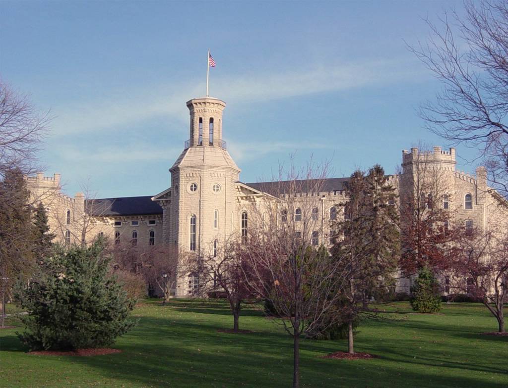
Blanchard Hall
Monument and historic site · National Register of Historic Places · 4.0 mi
Building located on the campus of Wheaton College in Wheaton, Illinois

Bloomingdale School
Monument and historic site · National Register of Historic Places · 3.7 mi
Bloomingdale, Illinois

DuPage County Historical Museum
Museum · National Register of Historic Places · 4.0 mi
Library

Glen Ellyn Downtown North Historic District
Monument and historic site · National Register of Historic Places · 4.6 mi
Historic district in Illinois, United States

Glen Ellyn Downtown South Historic District
Monument and historic site · National Register of Historic Places · 4.7 mi
Historic district in Illinois, United States

Glen Ellyn Main Street Historic District
Monument and historic site · National Register of Historic Places · 4.4 mi
Historic district in Illinois, United States

Old DuPage County Courthouse
Monument and historic site · National Register of Historic Places · 4.2 mi
Former courthouse in Wheaton, Illinois

Samuel and Eleanor Himmelfarb House and Studio
Monument and historic site · National Register of Historic Places · 4.2 mi
Historic house in Winfield, Illinois, United States

West Chicago City Museum
Museum · National Register of Historic Places · 4.4 mi
Museum in Chicago, Illinois, U.S., housed in the former Turner Town Hall, which is on the National Register of Historic Places and dates to 1884

Randecker's Hardware Store
Monument and historic site · National Register of Historic Places · 3.6 mi
Stacy's Tavern
Monument and historic site · National Register of Historic Places · 4.1 mi
5 more on the map.
Parks, trails and playgrounds84


Lake Ellyn Park
Park · National Register of Historic Places · 4.5 mi
Park in Glen Ellyn, Illinois

72 more on the map.
Restaurants and cafes84

Chili's
Restaurant · Tex-Mex · 1.9 mi
310 West Army Trail Road, Bloomingdale
Su-Th 11:00-22:00; Fr, Sa 11:00-23:00
First Watch
Restaurant · American, Breakfast · 2.0 mi
302 West Army Trail Road, Bloomingdale
07:00-14:30
Fry N' Wings
Restaurant · Fried Chicken, Asian, Fusion, Korean · 1.7 mi
369 West Army Trail Road, Bloomingdale
Tu-Su 11:00-22:00
Hummingbird Restaurant
Restaurant · American, Mexican · 2.5 mi
27W229 West Geneva Road, Winfield
Mo-Fr 08:00-20:00; Sa 07:00-20:00; Su 07:00-15:00
Mabuhay Restaurant & Catering
Restaurant · Filipino · 2.8 mi
1232 Bloomingdale Road, Glendale Heights
Mo-Fr 15:00-20:00; Sa 09:00-20:00; Su 11:00-16:00

Olive Garden
Restaurant · Italian · 1.8 mi
332 West Army Trail Road, Bloomingdale
Su-Th 11:00-23:00; Fr, Sa 11:00-24:00
Baskin-Robbins
Ice cream · 1.7 mi
880 West Army Trail Road, Carol Stream
Mo 05:00-22:00; Tu-Sa 04:00-22:00; Su 05:00-22:00
Oberweis
Ice cream · 1.7 mi
338 West Army Trail Road, Bloomingdale
Su-Th 10:00-22:00, Fr-Sa 10:00-23:00

72 more on the map.
History
In 1853, St. John Wahlund Catholic Church was built in what was then referred to as Gretna. The church was closed in 1867. When St. Michael's was opened in Wheaton in 1872, St. Stephen's parishioners were transferred to that parish. The church building was dismantled sometime in the late 19th century. St. Stephen's Cemetery was located adjacent to the church building and was last used for burial in 1910. St. Stephen's Cemetery (located north of the Great Western Trail behind the Ozinga concrete plant on St. Charles Road) was rededicated 100 years later on September 12, 2010.
In 1952, a farm from the area was featured on NBC; it was the site for the first outdoor telecast by the network in 1954.
A common misconception is that the municipality of Carol Stream was named for a local minor waterway. In fact, Carol Stream is one of the few communities in America that took its name from the first and last names of a living person: Carol Stream, the daughter of its founder Jay Stream. Carol Stream herself moved to Arizona as an adult, living there until her death on January 18, 2020.
From the History section of Carol Stream, Illinois on Wikipedia, under CC BY-SA 4.0.
Where to stay7
Courtyard by Marriott Chicago Bloomingdale
Motel and hotel · 1.8 mi
275 Knollwood Drive, Bloomingdale
Marriot Residence Inn Chicago Bloomingdale
Motel and hotel · 1.7 mi
295 Knollwood Drive, Bloomingdale
Holiday Inn & Suites Chicago-Carol Stream (Wheaton)
Motel and hotel · 1.4 mi
150 South Gary Avenue, Carol Stream
WoodSpring Suites Carol Stream
Motel and hotel · 1.2 mi
1160 North Gary Avenue, Carol Stream
Churches and places of worship20
Trinity Episcopal Church
Church · National Register of Historic Places · 3.9 mi
Heritage Presbyterian Church
Church · Presbyterian · 0.7 mi
965 Kuhn Road, Carol Stream
Crossroads Community Church
Church · 2.2 mi
1N100 North Gary Avenue, Carol Stream
Shopping23
Gas and EV charging14
Schools, colleges and libraries61
Healthcare5
Map of Carol Stream
250 places. The map loads OpenStreetMap tiles when you open it.
Climate by month
Monthly table
| Month | High | Low | Rain |
|---|---|---|---|
| Jan | 30°F | 16°F | 1.3 in |
| Feb | 35°F | 19°F | 1.2 in |
| Mar | 47°F | 28°F | 2.0 in |
| Apr | 60°F | 38°F | 3.4 in |
| May | 71°F | 49°F | 4.3 in |
| Jun | 81°F | 59°F | 3.6 in |
| Jul | 84°F | 63°F | 3.6 in |
| Aug | 82°F | 62°F | 3.8 in |
| Sep | 76°F | 54°F | 3.0 in |
| Oct | 62°F | 42°F | 3.0 in |
| Nov | 48°F | 31°F | 2.2 in |
| Dec | 35°F | 21°F | 1.7 in |
U.S. Climate Normals 1991-2020 for West Chicago Dupage Ap (6 mi away), NOAA NCEI.
People and cost of living
American Community Survey 5-year estimates, 2020-2024, U.S. Census Bureau. Estimates have margins of error, larger for small towns.
Disaster history
DuPage County has had 8 federal disaster declarations since 2000, most often for biologicals.
- 2020-03-26: Covid-19 Pandemic (Biological)
- 2020-03-13: Covid-19 (Biological)
- 2013-05-10: Severe Storms, Straight-Line Winds, And Flooding (Flood)
- 2011-03-17: Severe Winter Storm And Snowstorm (Snowstorm)
- 2010-08-19: Severe Storms And Flooding (Severe Storm)
- 2008-10-03: Severe Storms And Flooding (Severe Storm)
OpenFEMA disaster declarations summaries.
Getting there and nearby towns
DuPage County Airport (DPA) is the nearest airport with scheduled flights listed in OpenStreetMap, 6 miles away.
- Bloomingdale 3 mi northeast, about 5 min by car
- Bartlett 4 mi northwest, about 6 min by car
- Addison 6 mi east, about 10 min by car
- Bensenville 10 mi east, about 16 min by car
- Batavia 10 mi southwest, about 17 min by car
- Naperville 12 mi south, about 19 min by car
- Elgin 13 mi northwest, about 21 min by car
- Bellwood 13 mi east, about 22 min by car
- Aurora 14 mi southwest, about 22 min by car
- Arlington Heights 14 mi northeast, about 23 min by car
Drive times are estimates from straight-line distance, not routes.
Local news
Headlines from INDB, the NEMICO news database.
Reviews, tips and questions
Loading what members have shared...
Sources and licences
- NCES EDGE (Public domain): public schools
- NOAA NCEI U.S. Climate Normals 1991-2020 (Public domain): climate by month
- OpenFEMA (Public domain): disaster declarations
- OpenStreetMap contributors (ODbL 1.0): places, airports, map data
- U.S. Census Bureau (Public domain): population, income, housing, education, commute
- Wikidata (CC0 1.0): elevation, founding date, time zone, website, landmarks and historic places
- Wikimedia Commons (see each image): photos
- Wikipedia (CC BY-SA 4.0): overview and history text
Photo credits
- Stark Farm, Leoengb2, CC BY-SA 4.0
- Carol Stream, IL, USA - panoramio, bogdanstepniak, CC BY 3.0
- Carol Stream IL Steve Ravanesi Trail, Djmaschek, CC BY-SA 4.0
- Carol Stream IL Red Hawk Park, Djmaschek, CC BY-SA 4.0
- Holiday Inn & Suites Carol Stream (DuPage County, IL) (2508910895), DiscoverDuPage, CC BY 2.0
- Stratford Square Mall ^ Carol Stream from the sky - panoramio, radwoc, CC BY-SA 3.0
- St. Innocent of Moscow Russian Orthodox Church's dome and cross in Carol Stream, Illinois, Daniel X. O'Neil from USA, CC BY 2.0
- St. Innocent of Moscow Russian Orthodox Church, Carol Stream, Illinois, Daniel X. O'Neil from USA, CC BY 2.0
- AdamsMemorial, Teemu08 at en.wikipedia, CC BY-SA 3.0
- TrinityEpiscopalWheaton, Teemu08 at en.wikipedia, CC BY-SA 3.0
- Image Old Glen Ellyn Jr. High School, Boscophotos, CC BY-SA 3.0
- Samuel and Eleanor Himmelfarb House and Studio, Jim Roberts, CC BY-SA 4.0
- Bloomingdale School–Village Hall, Teemu08 ( talk ), CC BY-SA 3.0
- WheatonCollege, Neatpete86 at English Wikipedia, Public domain
- Alfred A. Schiller House, Teemu08 ( talk ), CC BY-SA 3.0
- DuPage County Courthouse, Teemu008, CC BY-SA 2.0
- GrandTheatreWheaton, Teemu08 at en.wikipedia, CC BY-SA 3.0
- Image Glen Theater, Boscophotos, CC BY-SA 3.0
- Glen Ellyn Main Street Historic District, Teemu08 ( talk ), CC BY-SA 3.0
- Lake-glen-ellyn-il, Dmadeo, CC BY-SA 3.0
- TurnerTownHall, Teemu08 at en.wikipedia, CC BY-SA 3.0
- Symphyotrichum novae-angliae flower (36), Greg Ulreich, CC0
- 9v into AAAA, The Smiling Bandit ( talk ), CC BY-SA 3.0
- Shih-Tzu in cart, Diana 98, CC BY-SA 4.0
- The RoomPlace (Bloomingdale, Illinois) 1, Wacky Windjammer, CC BY-SA 4.0
- Bicoloredgsd, Notlenny2, CC BY-SA 3.0
- Stratford Square Mall 2, Retail Thriller, CC BY-SA 4.0
- Cat laying in bed, Kaitlynlombardo34, CC BY-SA 4.0
- Simba Laying in a Cat Tree, Kaitlynlombardo34, CC BY-SA 4.0
- ISS046-E-22703 - View of Earth, Earth Science and Remote Sensing Unit , Lyndon B. Johnson Space Center, Public domain
- ISS008-E-6545 - View of Missouri, Earth Science and Remote Sensing Unit , Lyndon B. Johnson Space Center, Public domain
- ISS045-E-92687 - View of Earth, Earth Science and Remote Sensing Unit , Lyndon B. Johnson Space Center, Public domain
- ISS046-E-22702 - View of Earth, Earth Science and Remote Sensing Unit , Lyndon B. Johnson Space Center, Public domain
- ISS046-E-22701 - View of Earth, Earth Science and Remote Sensing Unit , Lyndon B. Johnson Space Center, Public domain
- ISS045-E-92686 - View of Earth, Earth Science and Remote Sensing Unit , Lyndon B. Johnson Space Center, Public domain
- ISS009-E-13518 - View of Wisconsin, Earth Science and Remote Sensing Unit , Lyndon B. Johnson Space Center, Public domain
- ISS045-E-92688 - View of Earth, Earth Science and Remote Sensing Unit , Lyndon B. Johnson Space Center, Public domain
- ISS006-E-49792 - View of Illinois, Earth Science and Remote Sensing Unit , Lyndon B. Johnson Space Center, Public domain
- ISS029-E-12603 - View of Earth, Earth Science and Remote Sensing Unit , Lyndon B. Johnson Space Center, Public domain
- West Branch - panoramio, Person1, CC BY 3.0


Page built October 30, 2026. Spotted a mistake? Tell us or suggest a place.