

Why visit Carthage
Townapedia lists 1 museum or landmark, 1 park or trail and 10 places to eat in and around town.
Highlights include Carthage Historic District.
July is the warmest month, with average highs of 92°F; January lows average 34°F.
Weather in Carthage
Forecast from the National Weather Service. Full forecast
About Carthage
The city of Carthage is the county seat of Leake County, Mississippi, United States. As of the 2020 census, Carthage had a population of 4,901.
From the Wikipedia article Carthage, Mississippi (this version), under CC BY-SA 4.0.
Museums and landmarks1

Carthage Historic District
Monument and historic site · National Register of Historic Places · 0.5 mi
Historic district in Carthage, Mississippi, United States
Parks, trails and playgrounds1

Restaurants and cafes10



Burger King
Fast food · Burger · 1.0 mi
503 Highway 16 West, Carthage
Mo-Sa 06:00-23:00; Su 07:00-23:00
Domino's
Fast food · Pizza · 0.6 mi
400 MS-16, Carthage
Mo-Th 10:00-23:00; Fr-Sa 10:00-24:00; Su 10:00-23:00
Popeyes
Fast food · Chicken · 0.9 mi
514 MS-35, Carthage
Mo-Th 10:00-22:00; Fr-Sa 10:00-23:00; Su 10:00-22:00
KFC
Fast food · Chicken · 0.8 mi
125 Highway 16 West, Carthage
Mo-Th 10:00-22:00; Fr-Sa 10:00-23:00; Su 10:00-22:00
Little Caesars
Fast food · Pizza · 1.4 mi
Mo-Th 11:00-19:30; Fr-Sa 11:00-20:30; Su 11:00-19:30
Churches and places of worship8

Saint Anne Catholic Church
Church · Roman Catholic
207 Red Dog Road, Carthage
History
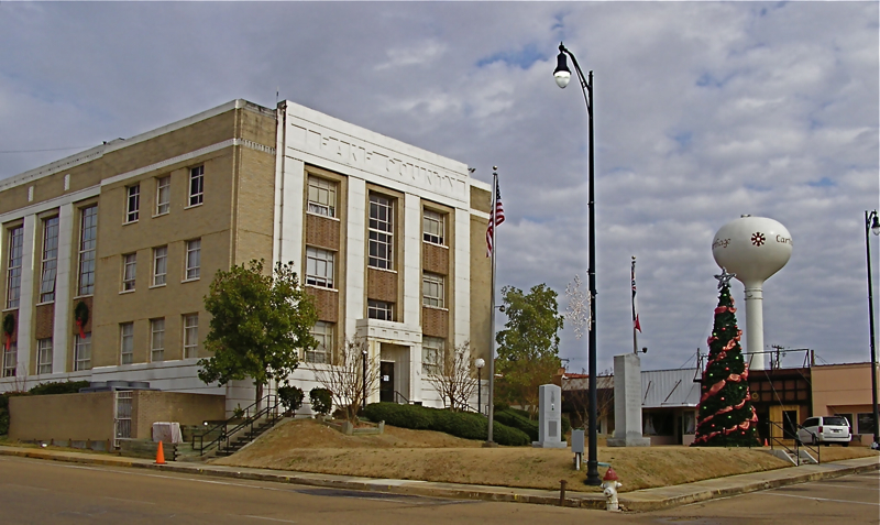
Carthage was established in 1834, and became the county seat. The Harris family were early settlers, and named the town after their former home of Carthage, Tennessee. A courthouse and jail were built in 1836, and a post office was established the following year. Carthage was incorporated in 1876. A brick courthouse replaced the previous one in 1877, and was replaced again in 1910. The present courthouse was designed by E. L. Malvaney and completed in 1939. The Carthaginian newspaper was established in 1872, and remains in publication today.
By 1900, agriculture was the primary industry in Leake County. The Pearl River, located 2 mi (3.2 km) south of Carthage, was used to ship goods by steamboat to and from Jackson, the state capital . Although a railroad eventually ran through Carthage, it did not play a significant role in the development of the town. In 1914, the Merrill Brothers Logging Company built a logging railroad from Canton to McAfee, passing through Carthage. The line was taken over in 1927 by the Canton and Carthage Railroad, which then established commercial service to Carthage. The railroad was abandoned in 1960.
From the History section of Carthage, Mississippi on Wikipedia, under CC BY-SA 4.0.
Shopping2
Gas and EV charging2
Schools, colleges and libraries8
Healthcare2
Map of Carthage
34 places. The map loads OpenStreetMap tiles when you open it.
Climate by month
Monthly table
| Month | High | Low | Rain | Snow |
|---|---|---|---|---|
| Jan | 57°F | 34°F | 5.7 in | 0.1 in |
| Feb | 61°F | 37°F | 5.3 in | 0.1 in |
| Mar | 69°F | 44°F | 5.0 in | 0.0 in |
| Apr | 76°F | 51°F | 6.3 in | 0.0 in |
| May | 83°F | 59°F | 4.4 in | 0.0 in |
| Jun | 89°F | 67°F | 3.9 in | 0.0 in |
| Jul | 92°F | 71°F | 5.1 in | 0.0 in |
| Aug | 92°F | 70°F | 4.7 in | 0.0 in |
| Sep | 88°F | 64°F | 3.8 in | 0.0 in |
| Oct | 78°F | 51°F | 3.9 in | 0.0 in |
| Nov | 67°F | 41°F | 4.3 in | 0.0 in |
| Dec | 58°F | 35°F | 5.3 in | 0.0 in |
U.S. Climate Normals 1991-2020 for Carthage (1 mi away), NOAA NCEI.
People and cost of living
American Community Survey 5-year estimates, 2020-2024, U.S. Census Bureau. Estimates have margins of error, larger for small towns.
Disaster history
Leake County has had 19 federal disaster declarations since 2000, most often for severe storms.
- 2026-02-06: Severe Winter Storm (Winter Storm)
- 2026-01-24: Severe Winter Storm (Winter Storm)
- 2023-08-12: Severe Storms, Straight-Line Winds, And Tornadoes. (Severe Storm)
- 2021-10-22: Hurricane Ida (Hurricane)
- 2021-08-28: Hurricane Ida (Hurricane)
- 2021-05-04: Severe Winter Storms (Severe Ice Storm)
OpenFEMA disaster declarations summaries.
Getting there and nearby towns
Kosciusko-Attala County Airport (OSX) is the nearest airport with scheduled flights listed in OpenStreetMap, 24 miles away.
- Canton 31 mi west, about 49 min by car
- Madison 39 mi southwest, about 1 h by car
- Brandon 42 mi southwest, about 1 h by car
- Flowood 42 mi southwest, about 1 h 15 min by car
- Ridgeland 43 mi southwest, about 1 h 15 min by car
- Pearl 46 mi southwest, about 1 h 15 min by car
- Jackson 49 mi southwest, about 1 h 15 min by car
- Yazoo City 51 mi west, about 1 h 30 min by car
- Clinton 54 mi southwest, about 1 h 30 min by car
- Meridian 55 mi southeast, about 1 h 30 min by car
Drive times are estimates from straight-line distance, not routes.
Local news
Headlines from INDB, the NEMICO news database.
Reviews, tips and questions
Loading what members have shared...
Sources and licences
- NCES EDGE (Public domain): public schools
- NOAA NCEI U.S. Climate Normals 1991-2020 (Public domain): climate by month
- OpenFEMA (Public domain): disaster declarations
- OpenStreetMap contributors (ODbL 1.0): places, airports, map data
- U.S. Census Bureau (Public domain): population, income, housing, education, commute
- Wikidata (CC0 1.0): elevation, founding date, time zone, website, landmarks and historic places
- Wikimedia Commons (see each image): photos
- Wikipedia (CC BY-SA 4.0): overview and history text
Photo credits
- Leake County Courthouse, Marduk, Public domain
Page built October 30, 2026. Spotted a mistake? Tell us or suggest a place.