


Kikwit, Democratic Republic of the Congo
Kikwit is a city of 509,367 people in Kwilu, Democratic Republic of the Congo.
Why visit Kikwit
Townapedia lists 2 museums and landmarks, 1 park or trail, 2 places to eat and 7 places to stay in and around town.
Weather in Kikwit
Forecast from MET Norway (CC BY 4.0). Full forecast
About Kikwit
Kikwit is the largest city in Kwilu Province, in the southwest of the Democratic Republic of the Congo. Located at the furthest navigable point of the Kwilu River, the urban area of Kikwit is primarily on the river's left bank. With over half a million inhabitants, Kikwit is a secondary city of the country. It is divided into four communes: Kazamba, Lukemi, Lukolela, and Nzinda.
From the Wikipedia article Kikwit (this version), under CC BY-SA 4.0.
Museums and landmarks2
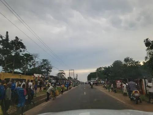
Centre culturel des frères josephites
Museum · 2.7 km
Un espace d'activité culturelles, salle des fêtes, restaurant, terrasse; géré par les frères josephites de Kinzambi

Parks, trails and playgrounds1

Restaurants and cafes2

Where to stay7




Churches and places of worship19
Gas and EV charging1
Schools, colleges and libraries23
Institut technique agricole et véterinaire de Kikwit (ITAVK, ex ITSA)
School · 0.9 km
Healthcare5
Map of Kikwit
60 places. The map loads OpenStreetMap tiles when you open it.
Getting there and nearby towns
Kikwit Airport (KKW) is the nearest airport with scheduled flights listed in OpenStreetMap, 3 km away.
- Bulungu 60 km northwest, about 1 h by car
- Idiofa 86 km east, about 1 h 30 min by car
Drive times are estimates from straight-line distance, not routes.
Local news
Headlines from INDB.
Reviews, tips and questions
Loading what members have shared...
Sources and licences
- GeoNames (CC BY 4.0): population, coordinates, regions and time zone
- Mapillary (see each image): photos
- OpenStreetMap contributors (ODbL 1.0): places, airports, map data
- Wikidata (CC0 1.0): elevation, founding date, time zone, website, landmarks and historic places
- Wikimedia Commons (see each image): photos
- Wikipedia (CC BY-SA 4.0): overview and history text
Photo credits
- Filair kikwit, BlueSalo, CC BY-SA 3.0
- Hôpital Général de Kikwit, 1995, CDC, Public domain
- Boulevard National, Kikwit - Mapillary (964371695028007), christebenya @ Mapillary, CC BY-SA 4.0
- Row of houses (1950-1960, Kikwit, Congo belge), bDom > 10.6 Millions de vues > 113.500 images/phot, Public domain
- Kikwit interior photo 1 (1950-1960, Kikwit, Congo belge), bDom > 10.6 Millions de vues > 113.500 images/phot, Public domain
- Kikwit river bank 2 (1950-1960, Kikwit, Congo belge), bDom > 10.6 Millions de vues > 113.500 images/phot, Public domain
- Farm in Kikwit (1950-1960, Kikwit, Congo belge), bDom > 10.6 Millions de vues > 113.500 images/phot, Public domain
- Kwilu river ferry (1950-1960, Kikwit, Congo belge), bDom > 10.6 Millions de vues > 113.500 images/phot, Public domain
- Kikwit interior photo 2 (1950-1960, Kikwit, Congo belge), bDom > 10.6 Millions de vues > 113.500 images/phot, Public domain
- Kikwit interior photo 3 (1950-1960, Kikwit, Congo belge), bDom > 10.6 Millions de vues > 113.500 images/phot, Public domain
- Arched building in Kikwit 3 (1950-1960, Kikwit, Congo belge), bDom > 10.6 Millions de vues > 113.500 images/phot, Public domain
- Kikwit house photo 4 (1950-1960, Kikwit, Congo belge), bDom > 10.6 Millions de vues > 113.500 images/phot, Public domain
- Kikwit street photo 5 (1950-1960, Kikwit, Congo belge), bDom > 10.6 Millions de vues > 113.500 images/phot, Public domain
- Kikwit street photo 17 (1950-1960, Kikwit, Congo belge), bDom > 10.6 Millions de vues > 113.500 images/phot, Public domain
- View of Kikwit (1950-1960, Kikwit, Congo belge), bDom > 10.6 Millions de vues > 113.500 images/phot, Public domain
- Arched building in Kikwit 2 (1950-1960, Kikwit, Congo belge), bDom > 10.6 Millions de vues > 113.500 images/phot, Public domain
- Building with people in Kikwit (1950-1960, Kikwit, Congo belge), bDom > 10.6 Millions de vues > 113.500 images/phot, Public domain
- Arched building in Kikwit 1 (1950-1960, Kikwit, Congo belge), bDom > 10.6 Millions de vues > 113.500 images/phot, Public domain
- Kikwit street photo 14 (1950-1960, Kikwit, Congo belge), bDom > 10.6 Millions de vues > 113.500 images/phot, Public domain
- Kikwit street photo 8 (1950-1960, Kikwit, Congo belge), bDom > 10.6 Millions de vues > 113.500 images/phot, Public domain
- Kikwit street photo 13 (1950-1960, Kikwit, Congo belge), bDom > 10.6 Millions de vues > 113.500 images/phot, Public domain
- Kikwit river bank 1 (1950-1960, Kikwit, Congo belge), bDom > 10.6 Millions de vues > 113.500 images/phot, Public domain
- Kikwit house photo 5 (1950-1960, Kikwit, Congo belge), bDom > 10.6 Millions de vues > 113.500 images/phot, Public domain
- Kikwit city hall (1950-1960, Kikwit, Congo belge), bDom > 10.6 Millions de vues > 113.500 images/phot, Public domain
- Kikwit street photo 4 (1950-1960, Kikwit, Congo belge), bDom > 10.6 Millions de vues > 113.500 images/phot, Public domain
- Kwilu river steamboat (1950-1960, Kikwit, Congo belge), bDom > 10.6 Millions de vues > 113.500 images/phot, Public domain
- Kikwit street photo 1 (1950-1960, Kikwit, Congo belge) 01, bDom > 10.6 Millions de vues > 113.500 images/phot, Public domain
- Kikwit street photo 11 (1950-1960, Kikwit, Congo belge), bDom > 10.6 Millions de vues > 113.500 images/phot, Public domain
- Kikwit street photo 12 (1950-1960, Kikwit, Congo belge), bDom > 10.6 Millions de vues > 113.500 images/phot, Public domain
- Kikwit street photo 18 (1950-1960, Kikwit, Congo belge), bDom > 10.6 Millions de vues > 113.500 images/phot, Public domain
- Kikwit street photo 9 (1950-1960, Kikwit, Congo belge), bDom > 10.6 Millions de vues > 113.500 images/phot, Public domain
- Kikwit house photo 3 (1950-1960, Kikwit, Congo belge), bDom > 10.6 Millions de vues > 113.500 images/phot, Public domain
- Two-story building in Kikwit (1950-1960, Kikwit, Congo belge), bDom > 10.6 Millions de vues > 113.500 images/phot, Public domain
- Kikwit street photo 6 (1950-1960, Kikwit, Congo belge), bDom > 10.6 Millions de vues > 113.500 images/phot, Public domain
- Kikwit street photo 15 (1950-1960, Kikwit, Congo belge), bDom > 10.6 Millions de vues > 113.500 images/phot, Public domain
- Kikwit house photo 2 (1950-1960, Kikwit, Congo belge), bDom > 10.6 Millions de vues > 113.500 images/phot, Public domain
- Kikwit street photo 3 (1950-1960, Kikwit, Congo belge), bDom > 10.6 Millions de vues > 113.500 images/phot, Public domain
- Kikwit street photo 16 (1950-1960, Kikwit, Congo belge), bDom > 10.6 Millions de vues > 113.500 images/phot, Public domain
- Kikwit street photo 2 (1950-1960, Kikwit, Congo belge), bDom > 10.6 Millions de vues > 113.500 images/phot, Public domain
- 中国农技组基奎特小组基地〔油画〕 - panoramio, zengsx, CC BY-SA 3.0
- Street-level photo, OSP1, CC BY-SA 4.0
- Street-level photo, OSP1, CC BY-SA 4.0
- Street-level photo, OSP1, CC BY-SA 4.0
- Street-level photo, christebenya, CC BY-SA 4.0
- Street-level photo, christebenya, CC BY-SA 4.0
- Street-level photo, christebenya, CC BY-SA 4.0
- Street-level photo, pmbuya, CC BY-SA 4.0
- Street-level photo, christebenya, CC BY-SA 4.0
- Street-level photo, pmbuya, CC BY-SA 4.0
- Street-level photo, pmbuya, CC BY-SA 4.0
- Street-level photo, pmbuya, CC BY-SA 4.0


Page built November 8, 2026. Spotted a mistake? Tell us or suggest a place.