


Zongo, Democratic Republic of the Congo
Zongo is a town of 48,658 people in Sud-Ubangi, Democratic Republic of the Congo.
Weather in Zongo
Forecast from MET Norway (CC BY 4.0). Full forecast
About Zongo
Zongo is a city in Sud-Ubangi Province in the northwestern part of the Democratic Republic of Congo, lying on the south bank of the Ubangi River, across from Bangui in the Central African Republic. It is linked by ferry to Bangui but has declined in importance as a transport hub since much traffic moved east in the late 1980s.
From the Wikipedia article Zongo, Sud-Ubangi (DR Congo) (this version), under CC BY-SA 4.0.
Travel tips from other travellers: Zongo on Wikivoyage (CC BY-SA 4.0).
Churches and places of worship3

Cathédrale Notre-Dame
Church · 3.5 km
Roman Catholic cathedral in Bangui, Central African Republic
Church of Fatima, Bangui
Church · 7.0 km
Building in Central African Republic
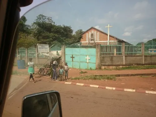


Notre Dame D'Afrique
Church · 7.4 km
Church in Bangui, Central African Republic
Schools, colleges and libraries2
University of Bangui
School · 5.0 km
University in the Central African Republic (IAU-019564)

Map of Zongo
5 places. The map loads OpenStreetMap tiles when you open it.
Getting there and nearby towns
Libenge Airport (LIE) is the nearest airport with scheduled flights listed in OpenStreetMap, 80 km away.
- Libenge 77 km south, about 1 h 15 min by car
Drive times are estimates from straight-line distance, not routes.
Local news
Headlines from INDB.
Reviews, tips and questions
Loading what members have shared...
Sources and licences
- GeoNames (CC BY 4.0): population, coordinates, regions and time zone
- Mapillary (see each image): photos
- OpenStreetMap contributors (ODbL 1.0): places, airports, map data
- Wikidata (CC0 1.0): elevation, founding date, time zone, website, landmarks and historic places
- Wikimedia Commons (see each image): photos
- Wikipedia (CC BY-SA 4.0): overview and history text
Photo credits
- Berge Zongo vue de Bangui 02, Imoini22, CC BY-SA 4.0
- Berge Zongo vue de Bangui 03, Imoini22, CC BY-SA 4.0
- Une foule devant la Cathédrale de Bangui, le 7 mai 2018, Freeman Sipila (VOA), Public domain
- Birao burnt down, © UNICEF | Pierre Holtz/ hdptcar , Bangui, Central African Republic, CC BY-SA 2.0
- Bâtiment université de Bangui 05, Imoini22, CC BY-SA 4.0
- Solar annular eclipse of January 15, 2010 in Bangui, Central African Republic, Tino Kreutzer, CC BY 3.0
- Fleurs50, Kondotikodro, CC BY-SA 4.0
- Fleurs51, Kondotikodro, CC BY-SA 4.0
- KIMG0758 01, Imoini22, CC BY-SA 4.0
- KIMG0758 03, Imoini22, CC BY-SA 4.0
- KIMG0758 02, Imoini22, CC BY-SA 4.0
- Bangui Crossing - panoramio, Michael Walsh, CC BY 3.0
- Michel Gohou (cropped), Bptanguy237, CC0
- Blaise Pascal Tanguy en compagnie de Michel Gohou, Bptanguy237, CC0
- Bangui Centre, Alllexxxis, CC BY-SA 4.0
- Bangui City Centre, Alllexxxis, CC BY-SA 4.0
- Bangui City WV banner, Alllexxxis, CC BY-SA 4.0
- Alexandre Vacante, président d’AZIKA Coopérative Miniers Associés, Vacante Alexandre, CC BY 4.0
- SUPER MARCHE RAYAN - panoramio, HASSAN AKHRAS, CC BY 3.0
- Tam-Tam 02, Kondotikodro, CC BY-SA 4.0
- Tam-Tam 01, Kondotikodro, CC BY-SA 4.0
- Kpignon Gervais Symphorien acteur comédien et humoriste, DUDIEU, CC BY-SA 4.0
- Gervais Symphorien Kpignon, DUDIEU, CC BY-SA 4.0
- Ballet National, Kondotikodro, CC BY-SA 4.0
- Sable à la berge, Kondotikodro, CC BY-SA 4.0
- Bureau BCGS, Kondotikodro, CC BY-SA 4.0
- KIMG0581 11, Imoini22, CC BY-SA 4.0
- KIMG0581 14, Imoini22, CC BY-SA 4.0
- KIMG0581 12, Imoini22, CC BY-SA 4.0
- KIMG0581 26, Imoini22, CC BY-SA 4.0
- KIMG0581 27, Imoini22, CC BY-SA 4.0
- KIMG0581 25, Imoini22, CC BY-SA 4.0
- KIMG0582 10, Imoini22, CC BY-SA 4.0
- KIMG0581 22, Imoini22, CC BY-SA 4.0
- KIMG0581 13, Imoini22, CC BY-SA 4.0
- KIMG0581 21, Imoini22, CC BY-SA 4.0
- KIMG0581 23, Imoini22, CC BY-SA 4.0
- KIMG0581 15, Imoini22, CC BY-SA 4.0
- KIMG0581 16, Imoini22, CC BY-SA 4.0
- KIMG0581 08, Imoini22, CC BY-SA 4.0
- Street-level photo, flavour, CC BY-SA 4.0


Page built November 8, 2026. Spotted a mistake? Tell us or suggest a place.