
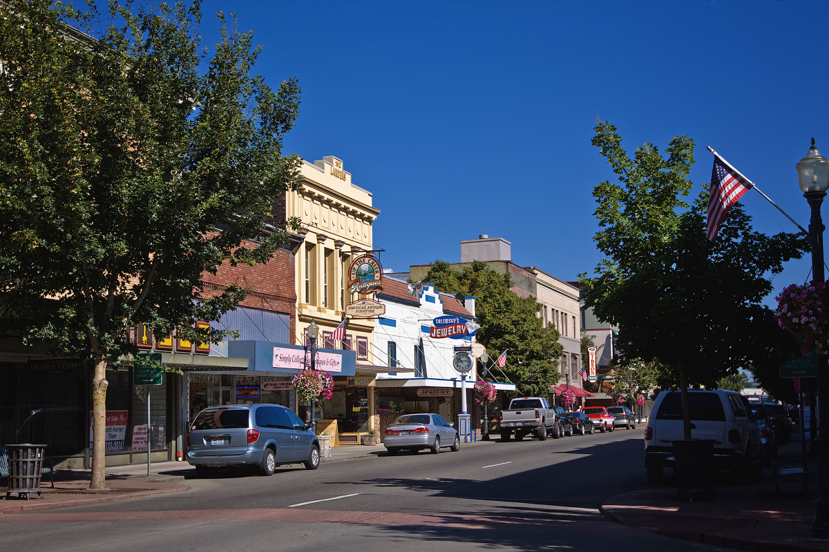


Centralia, Washington
Centralia is a city of 18,830 people in Lewis County, Washington, founded in 1852.
Why visit Centralia
Townapedia lists 20 museums and landmarks, 18 parks and trails, 60 places to eat, 13 places to stay and 6 attractions in and around town.
Highlights include The Olympic Club Theater, Fox Theater, The Sentinel and Burlington Northern Railroad Depot.
August is the warmest month, with average highs of 78°F; February lows average 34°F.
Weather in Centralia
Forecast from the National Weather Service. Full forecast
About Centralia
Centralia () is a city in Lewis County, Washington, United States. It is located along Interstate 5 near the midpoint between Seattle and Portland, Oregon. The city had a population of 18,183 at the 2020 census. Centralia is twinned with Chehalis, located to the south near the confluence of the Chehalis and Newaukum rivers.
From the Wikipedia article Centralia, Washington (this version), under CC BY-SA 4.0.
Things to do6


Museums and landmarks20
The Sentinel
Monument and historic site · National Register of Historic Places · 1.1 mi
National Register of Historic Places statue in Centralia, Washington

Burlington Northern Railroad Depot
Museum · National Register of Historic Places · 4.1 mi
Railroad depot, historical society, museum, and NRHP-listed site in Chehalis, Washington

Centralia Downtown Historic District
Monument and historic site · National Register of Historic Places · 1.2 mi
Historic district in Centralia, Washington
Centralia station
Monument and historic site · National Register of Historic Places · 1.2 mi
Train station in Centralia, Washington, USA

Chehalis Downtown Historic District
Monument and historic site · National Register of Historic Places · 4.2 mi
Historic district in Chehalis, Washington

Chehalis Post Office
Monument and historic site · National Register of Historic Places · 4.3 mi
NRHP-listed site in Chehalis, Washington

George E. Birge House
Monument and historic site · National Register of Historic Places · 0.9 mi
Historic house in Centralia, Washington

Hillside Historic District
Monument and historic site · National Register of Historic Places · 4.3 mi
Historic district in Chehalis, Washington, United States

Hubbard Bungalow
Monument and historic site · National Register of Historic Places · 0.7 mi
NRHP-listed residence in Centralia, Washington, US

Joseph Borst House
Monument and historic site · National Register of Historic Places · 0.6 mi
Historic house in Centralia, Washington

Lewis County Courthouse
Monument and historic site · National Register of Historic Places · 4.4 mi
Courthouse in Washington state, US


Main Post Office
Monument and historic site · National Register of Historic Places · 1.1 mi
U.S. Post Office in Centralia, Washington
8 more on the map.
Parks, trails and playgrounds18

Seminary Hill Natural Area
Park · 1.7 mi
Natural area in the city of Centrailia, Washington, United States of America
902 East Locust Street, Centralia
sunrise-sunset
Centralia College Node
Park · 0.9 mi
A place for students to learn about plants also a place to rest and relax
Centralia College Wind Tower Energy Ball
Park · 0.8 mi
Centralia College Wind Tower and Node
6 more on the map.
Restaurants and cafes60

Santa Lucia Coffee Roasters
Cafe · Coffee Shop · 1.2 mi
202 South Tower Avenue, Centralia
Mo-Fr 07:00-17:00, Sa 08:00-15:00, Su 09:00 - 15:00
The Station Coffee Bar & Bistro
Cafe · Coffee Shop · 1.2 mi
120 South Tower Avenue, Centralia
Mo-We 08:00-18:00; Th-Sa 08:00-21:00; Su 08:00-17:00

Dutch Bros. Coffee
Cafe · Coffee Shop
512 Harrison Avenue, Centralia
Mo-Th 05:00-22:00; Fr-Sa 05:00-23:00; Su 05:00-22:00
La Tarasca
Restaurant · Mexican · 0.6 mi
Authentic Mexican Food
1001 W. Main Street
Tu off

O'Blarney's Irish Pub
Bar and pub · 1.1 mi
221 North Tower Avenue, Centralia
Mo-Fr 11:00-02:00, Sa-Su 08:00-02:00

Northwest Grind Centralia
Cafe · Coffee Shop · 1.0 mi
606 West Reynolds Avenue, Centralia
Mo-Fr 05:30-18:00, Sa 06:30-18:00, Su 07:00-18:00
48 more on the map.
Where to stay13
Centralia Square Grand Ballroom and Hotel
Motel and hotel · 1.1 mi
202 Central Collage Boulevard, Centralia
Churches and places of worship21
Centralia Bible Chapel
Church · Nondenominational · 1.1 mi
209 North Pearl Street, Centralia
Mountain View Baptist Church
Church · Baptist · 0.4 mi
1201 Belmont Avenue, Centralia
Shopping8
Gas and EV charging13
Schools, colleges and libraries28
Healthcare4
Map of Centralia
191 places. The map loads OpenStreetMap tiles when you open it.
Climate by month
Monthly table
| Month | High | Low | Rain |
|---|---|---|---|
| Jan | 46°F | 34°F | 5.8 in |
| Feb | 50°F | 34°F | 4.2 in |
| Mar | 54°F | 36°F | 4.4 in |
| Apr | 60°F | 39°F | 3.2 in |
| May | 67°F | 44°F | 2.4 in |
| Jun | 71°F | 49°F | 1.5 in |
| Jul | 78°F | 53°F | 0.5 in |
| Aug | 78°F | 53°F | 0.8 in |
| Sep | 73°F | 48°F | 1.6 in |
| Oct | 61°F | 43°F | 4.0 in |
| Nov | 51°F | 37°F | 6.5 in |
| Dec | 45°F | 34°F | 6.4 in |
U.S. Climate Normals 1991-2020 for Centralia Hcn (1 mi away), NOAA NCEI.
People and cost of living
American Community Survey 5-year estimates, 2020-2024, U.S. Census Bureau. Estimates have margins of error, larger for small towns.
Disaster history
Lewis County has had 22 federal disaster declarations since 2000, most often for severe storms.
- 2026-04-07: Severe Storms, Straight-Line Winds, Flooding, Landslides, And Mudslides (Flood)
- 2025-12-12: Severe Storms, Straight-Line Winds, Flooding, Landslides, And Mudslides (Flood)
- 2024-04-28: Severe Winter Storms, Straight-Line Winds, Flooding, Landslides, And Mudslides (Severe Storm)
- 2023-01-12: Severe Winter Storm, Straight-Line Winds, Flooding, Landslides, And Mudslides (Severe Storm)
- 2022-03-29: Severe Winter Storms, Snowstorms, Straight-Line Winds, Flooding (Flood)
- 2022-01-05: Severe Storms, Straight-Line Winds, Flooding, Landslides, And Mudslides (Flood)
OpenFEMA disaster declarations summaries.
Getting there and nearby towns
Chehalis-Centralia Airport (CLS) is the nearest airport with scheduled flights listed in OpenStreetMap, 3 miles away.
- Fords Prairie 2 mi northwest, about 3 min by car
- Chehalis 4 mi south, about 7 min by car
- Grand Mound 5 mi north, about 9 min by car
- Rochester 8 mi northwest, about 13 min by car
- Aberdeen 43 mi northwest, about 1 h 15 min by car
- Artondale 43 mi north, about 1 h 15 min by car
- Tacoma 44 mi northeast, about 1 h 15 min by car
- Bonney Lake 50 mi northeast, about 1 h 15 min by car
- Auburn 54 mi northeast, about 1 h 30 min by car
- Astoria 55 mi southwest, about 1 h 30 min by car
Drive times are estimates from straight-line distance, not routes.
Local news
Headlines from INDB, the NEMICO news database.
Reviews, tips and questions
Loading what members have shared...
Sources and licences
- NCES EDGE (Public domain): public schools
- NOAA NCEI U.S. Climate Normals 1991-2020 (Public domain): climate by month
- OpenFEMA (Public domain): disaster declarations
- OpenStreetMap contributors (ODbL 1.0): places, airports, map data
- U.S. Census Bureau (Public domain): population, income, housing, education, commute
- Wikidata (CC0 1.0): elevation, founding date, time zone, website, landmarks and historic places
- Wikimedia Commons (see each image): photos
- Wikipedia (CC BY-SA 4.0): overview and history text
Photo credits
- Centralia Downtown Historic District, Steven Pavlov, CC BY-SA 3.0
- The Sentinel, statue in Centralia, Steven Pavlov, CC BY-SA 3.0
- Hillside HD Chehalis 96000841 NRHP Lewis County, WA, Jon Roanhaus, CC BY-SA 3.0
- Olympic Club Hotel, G@nymede at en.wikipedia, CC BY-SA 3.0
- Burlington Northern Depot, Chehalis 01, Unknown author Unknown author, Public domain
- Centralia Union Depot, Steven Pavlov, CC BY-SA 3.0
- Wesley Everest grave 03, Joe Mabel, CC BY-SA 3.0
- Chehalis Post Office 2023 01, Shortiefourten, CC BY-SA 4.0
- Centralia, WA - Hubbard Bungalow 01, Joe Mabel, CC BY-SA 3.0
- Intersection of Pennsylvania Avenue and West Side Street Looking west., Lpinn, CC BY-SA 3.0
- O K Palmer House, Lionel Pinn, CC BY-SA 3.0
- Former St. Helens Hotel in Chehalis, Steven Pavlov, CC BY-SA 3.0
- Historic Borst family home, TateRay, CC BY-SA 4.0
- Birge House Centralia 86003375 NRHP Lewis County, WA, Jon Roanhaus, CC BY-SA 3.0
- Centralia, WA - main post office 01, Joe Mabel, CC BY-SA 3.0
- Chehalis - Old Lewis County Courthouse 02, Joe Mabel, CC BY 3.0


Page built October 30, 2026. Spotted a mistake? Tell us or suggest a place.