


Cherry Hill, Virginia
Cherry Hill is a community of 26,044 people in Prince William County, Virginia.
Why visit Cherry Hill
Townapedia lists 17 museums and landmarks, 15 parks and trails, 53 places to eat, 9 places to stay and 3 attractions in and around town.
Highlights include Marine Corps University, Weems–Botts Museum, Cabin Branch Pyrite Mine Historic District and Leesylvania State Park.
July is the warmest month, with average highs of 88°F; January lows average 28°F.
Weather in Cherry Hill
Forecast from the National Weather Service. Full forecast
About Cherry Hill
Cherry Hill is a census-designated place (CDP) in Prince William County, Virginia, United States. The population was 16,000 according to the 2010 Census. As of the 2020 census, it was estimated to be 23,683. The CDP is made up of the Cherry Hill peninsula, to the northeast of the town of Dumfries.
From the Wikipedia article Cherry Hill, Prince William County, Virginia (this version), under CC BY-SA 4.0.
Things to do3

Marine Corps University
School · 3.5 mi
University for the U.S. Marine Corps


Museums and landmarks17

Weems–Botts Museum
Museum · National Register of Historic Places · 2.4 mi
Building in Virginia, United States

Cabin Branch Pyrite Mine Historic District
Monument and historic site · National Register of Historic Places · 3.5 mi
Historic district in Virginia, United States
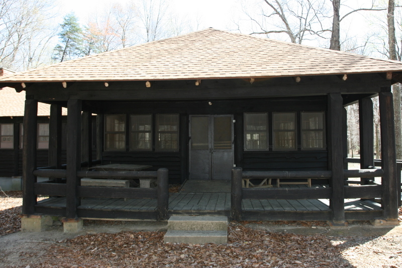
Chopawamsic Recreational Demonstration Area Cabin Camp 1
Monument and historic site · National Register of Historic Places · 4.3 mi
Civilian Conservation Corps campsite

Commanding General's Quarters, Quantico Marine Base
Monument and historic site · National Register of Historic Places · 2.8 mi
Historic house in Virginia, United States

Old Hotel
Monument and historic site · National Register of Historic Places · 2.0 mi
Hotel in Dumfries, Virginia

Orenda/SP-26 Historic District, Chopawamsic RDA Camp 3
Monument and historic site · National Register of Historic Places · 4.0 mi
Recreational demonstration camp

Pleasant Historic District, Chopawamsic RDA Camp 4
Monument and historic site · National Register of Historic Places · 4.0 mi
Historic district in Virginia, United States

Rippon Lodge
Monument and historic site · National Register of Historic Places · 3.2 mi
Human settlement in Virginia, United States of America

Freestone Point Confederate Battery
Monument and historic site · National Register of Historic Places · 2.6 mi

Old Town Hall and School
Monument and historic site · National Register of Historic Places · 2.0 mi

National Museum of the Marine Corps
Museum · 3.5 mi
Official museum of the United States Marine Corps, in Triangle, Virginia


5 more on the map.
Parks, trails and playgrounds15


C. Lacey Compton Neighborhood Park
Park · 0.9 mi
17301 River Ridge Boulevard, Woodbridge

3 more on the map.
Restaurants and cafes53

Baskin-Robbins
Ice cream · Ice Cream · 2.4 mi
18021 Main Street, Dumfries
Mo-Fr 04:30-22:00; Sa-Su 05:30-22:00


1609 Prime Cuts + Cocktails
Restaurant · Steak House · 2.1 mi
17680 Colonial Street, Dumfries

California Tortilla
Restaurant · Mexican · 2.6 mi
3934 Fettler Park Drive, Dumfries
Cold Stone Creamery
Ice cream · Ice Cream · 2.2 mi
16430 Navigation Drive, Woodbridge
41 more on the map.
History
The eastern side of the peninsula was long occupied by low-density single-family homes, while the western side remained more industrial. This changed with the construction of Southbridge on the Potomac, a master-planned community of approximately 1,500 homes on 600 acres of land in southwestern Cherry Hill, founded in 1990 and built largely from the mid-1990s until the mid-2000s; River Oaks, a community consisting of 1,122 homes was built during the same time period just to the north of Southbridge on the Potomac.
The smaller community of Eagle Pointe was built in the late 2000s in western Cherry Hill, between U.S. Route 1 and Interstate 95, as were Port Potomac and the single-family house section of Powells Landing, located just across U.S. Route 1 from Eagle Pointe. The townhouse section of Powell's Landing was built in the mid-2010s.
Potomac Shores is a large community of both single-family homes and townhomes under construction by Beazer Homes USA, Drees Homes, PulteGroup, NVR, Inc., and Stanley Martin Homes on the previously low-density eastern side of the peninsula.
From the History section of Cherry Hill, Prince William County, Virginia on Wikipedia, under CC BY-SA 4.0.
Where to stay9
Candlewood Suites Dumfries - Quantico
Motel and hotel · 2.5 mi
16927 Old Stage Road, Dumfries
Churches and places of worship13
Iglesia Cristiana Cristo Es Tu Libertador
Church · 2.4 mi
17832 Main Street, Dumfries
The Church of Pentecost Shiloh Assembly
Church · 1.5 mi
17311 Richmond Highway, Dumfries
Shopping6
Todos Neighborhood Market
Grocery · 1.7 mi
16593 River Ridge Boulevard, Woodbridge
Gas and EV charging12
Schools, colleges and libraries40
Fannie W. Fitzgerald Elementary
School · 3.6 mi
15500 Benita Fitzgerald Drive, Woodbridge
Healthcare6
Greater Prince William Community Health Center
Clinic and pharmacy · 2.2 mi
17739 Main Street, Dumfries
Map of Cherry Hill
174 places. The map loads OpenStreetMap tiles when you open it.
Climate by month
Monthly table
| Month | High | Low | Rain | Snow |
|---|---|---|---|---|
| Jan | 45°F | 28°F | 2.7 in | 3.5 in |
| Feb | 48°F | 30°F | 2.4 in | 5.8 in |
| Mar | 56°F | 37°F | 3.6 in | 1.4 in |
| Apr | 68°F | 47°F | 3.2 in | 0.0 in |
| May | 76°F | 57°F | 3.6 in | 0.0 in |
| Jun | 84°F | 66°F | 3.5 in | 0.0 in |
| Jul | 88°F | 71°F | 4.6 in | 0.0 in |
| Aug | 86°F | 69°F | 4.2 in | 0.0 in |
| Sep | 80°F | 62°F | 3.4 in | 0.0 in |
| Oct | 69°F | 50°F | 3.3 in | 0.0 in |
| Nov | 58°F | 39°F | 3.1 in | 0.0 in |
| Dec | 49°F | 32°F | 3.3 in | 1.7 in |
U.S. Climate Normals 1991-2020 for Quantico Mcas (5 mi away), NOAA NCEI.
People and cost of living
American Community Survey 5-year estimates, 2020-2024, U.S. Census Bureau. Estimates have margins of error, larger for small towns.
Disaster history
Prince William County has had 14 federal disaster declarations since 2000, most often for hurricanes.
- 2026-01-23: Severe Winter Storm (Winter Storm)
- 2020-04-02: Covid-19 Pandemic (Biological)
- 2020-03-13: Covid-19 (Biological)
- 2018-09-11: Hurricane Florence (Hurricane)
- 2016-03-07: Severe Winter Storm And Snowstorm (Snowstorm)
- 2012-11-26: Hurricane Sandy (Hurricane)
OpenFEMA disaster declarations summaries.
Getting there and nearby towns
Quantico Marine Corps Airfield/Turner Field (NYG) is the nearest airport with scheduled flights listed in OpenStreetMap, 4 miles away.
- Buckhall 13 mi northwest, about 22 min by car
- Burke 15 mi north, about 23 min by car
- Burke Centre 15 mi north, about 25 min by car
- Bensville 16 mi east, about 25 min by car
- Accokeek 17 mi northeast, about 28 min by car
- La Plata 17 mi east, about 28 min by car
- Annandale 19 mi north, about 30 min by car
- Fort Washington 19 mi northeast, about 30 min by car
- Alexandria 21 mi northeast, about 33 min by car
- Waldorf 21 mi east, about 33 min by car
Drive times are estimates from straight-line distance, not routes.
Local news
Headlines from INDB, the NEMICO news database.
Reviews, tips and questions
Loading what members have shared...
Sources and licences
- NCES EDGE (Public domain): public schools
- NOAA NCEI U.S. Climate Normals 1991-2020 (Public domain): climate by month
- OpenFEMA (Public domain): disaster declarations
- OpenStreetMap contributors (ODbL 1.0): places, airports, map data
- U.S. Census Bureau (Public domain): population, income, housing, education, commute
- Wikidata (CC0 1.0): landmarks and historic places
- Wikimedia Commons (see each image): photos
- Wikipedia (CC BY-SA 4.0): overview and history text
Photo credits
- 2019-10-17 08 56 22 View north along Virginia State Route 234 (Dumfries Road) at the exit for Interstate 95 NORTH (Washington) in Cherry Hill, Prince William County, Virginia, Famartin, CC BY-SA 4.0
- 2019-06-24 13 21 46 View north along Interstate 95 from the overpass for Virginia State Route 234 (Dumfries Road) on the edge of Cherry Hill and Montclair in Prince William County, Virginia, Famartin, CC BY-SA 4.0
- 2019-05-29 11 58 16 View south along Interstate 95 at Exit 152A (Virginia State Route 234 SOUTH, Dumfries) on the edge of Montclair and Cherry Hill in Prince William County, Virginia, Famartin, CC BY-SA 4.0
- 2019-05-29 11 55 05 View south along Interstate 95 at Exit 152B (Virginia State Route 234 NORTH, Manassas) on the edge of Montclair and Cherry Hill in Prince William County, Virginia, Famartin, CC BY-SA 4.0
- Weems-Botts House (Dumfries, Virginia) 001, Leonard J. DeFrancisci, CC BY-SA 3.0
- OLD HOTEL; PRINCE WILLIAM COUNTY, Jerrye & Roy Klotz, MD, CC BY-SA 3.0
- Commander's House, LeiferJM, CC BY-SA 3.0
- Chopawamsic Camp 4 dining VA NPS, National Park Service, Public domain
- Rippon Lodge Today, WhiteKMJK, Public domain
- Chopawamsic Camp 1 VA NPS, National Park Service, Public domain
- AACA concentrate bin ruins VA NPS, National Park Service, Public domain
- OLD TOWN HALL AND SCHOOL, PRINCE WILLIAM COUNTY, VA, Jerrye & Roy Klotz, MD, CC BY-SA 3.0
- FREESTONE POINT CONFEDERATE BATTERY, PRINCE WILLIAM CO. VA, Jerrye & Roy Klotz, MD, CC BY-SA 3.0
- Museum of the marines corps, RadioFan ( talk ), CC BY-SA 3.0
- Marine Corps Air-Ground Museum 05, U.S. Marine Corps, Public domain
- Virginia-Va-state-stair-baluster-install (30267627595), The Finishing Company Richmond Va from Richmond,Virginia, United States, CC BY 2.0
- Hands Free Breast Pump, LeslieKnope345, CC0
- Frozen Breast milk, LeslieKnope345, CC0
- Woven Thread (EP) Cover, Euwareentare, CC BY-SA 4.0
- 2017 Think Outside Photo Contest entry (37593656591), Virginia State Parks, CC BY 2.0
- Powell's Creek - panoramio, Fredlyfish4, CC BY-SA 4.0
- Railroad bridge over Powell's Creek - panoramio, Fredlyfish4, CC BY-SA 4.0
- 2018-10-10 10 23 35 View north along U.S. Route 1 (Jefferson Davis Highway) just south of Virginia State Route 234 (Dumfries Road) in Dumfries, Prince William County, Virginia, Famartin, CC BY-SA 4.0
- Powell's Creek Trail - panoramio, Fredlyfish4, CC BY-SA 4.0
- Leesylvania State Park, Woodbridge, Virginia, December 29, 2018 (53070627934), Judy Gallagher, CC BY 2.0
- Leesylvania State Park, Woodbridge, Virginia (38729080164), Judy Gallagher, CC BY 2.0
- Leesylvania State Park, Fredlyfish4, CC BY-SA 3.0
- 4-366 - Dawn's Early Light, Leesylvania State Park, Woodbridge, Virginia - Flickr - Judy Gallagher, Judy Gallagher, CC BY 2.0
- Leesylvania SP 10-19-21-Sassafras, vastateparksstaff, CC BY 2.0
- Japanese Mystery Snail - Cipangopaludina japonica, Leesylvania State Park, Woodbridge, Virginia, Judy Gallagher, CC BY 2.0
- Leesylvania SP 10-21-21-River View, vastateparksstaff, CC BY 2.0
- Leesylvania SP 10-19-21-Devils Walking stick, vastateparksstaff, CC BY 2.0
- Leesylvania SP 10-19-21-Powells Creek, vastateparksstaff, CC BY 2.0
- 2018-10-10 10 12 38 View south along U.S. Route 1 (Main Street) at Possum Point Road in Dumfries, Prince William County, Virginia, Famartin, CC BY-SA 4.0
- Ice, Leesylvania State Park, Woodbridge, Virginia (25503121548), Judy Gallagher, CC BY 2.0
- Leesylvania State Park, Woodbridge, Virginia (24507914707), Judy Gallagher, CC BY 2.0
- Leesylvania State Park, Woodbridge, Virginia (26265667258), Judy Gallagher, CC BY 2.0
- A Colony of Gulls, Leesylvania State Park, Woodbridge, Virginia (39294023245), Judy Gallagher, CC BY 2.0
- Builder grade white picket count (30232755626), The Finishing Company Richmond Va from Richmond,Virginia, United States, CC BY 2.0
- Quantico Dam - Dumfries, VA (15954586619), U. S. Fish and Wildlife Service - Northeast Region, Public domain


Page built October 30, 2026. Spotted a mistake? Tell us or suggest a place.