
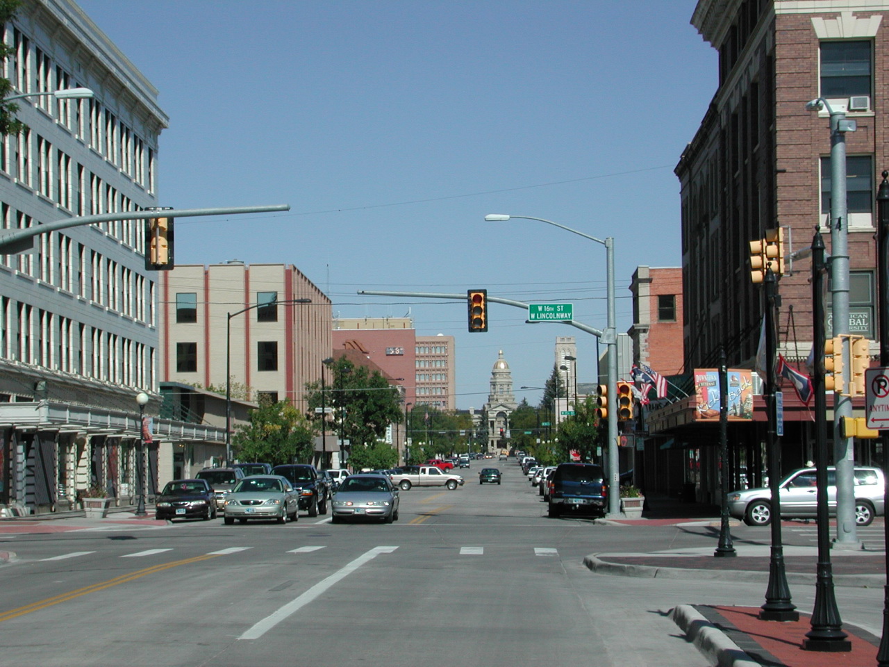


Cheyenne, Wyoming
Cheyenne is a city of 65,239 people in Laramie County, Wyoming, founded in 1867.
Why visit Cheyenne
Townapedia lists 68 museums and landmarks, 76 parks and trails, 136 places to eat, 47 places to stay and 11 attractions in and around town.
Highlights include Atlas Theatre, Capitol City Stadium Cinemas, Joseph C. O`Mahoney Federal Center and Cheyenne Depot Museum.
July is the warmest month, with average highs of 83°F; February lows average 18°F, and about 66 inches of snow fall in a normal year.
Weather in Cheyenne
Forecast from the National Weather Service. Full forecast
About Cheyenne
Cheyenne is the capital and most populous city of the U.S. state of Wyoming. Its population was 65,132 at the 2020 census, while the Cheyenne metropolitan area encompassing all of Laramie County had an estimated 102,000 residents. Cheyenne is situated on Crow Creek and Dry Creek. It is the county seat of Laramie County.
From the Wikipedia article Cheyenne, Wyoming (this version), under CC BY-SA 4.0.
Things to do11

Atlas Theatre
Cinema and theater · National Register of Historic Places · 0.9 mi
Theater and movie theater in Cheyenne, Wyoming, United States
211 West Lincolnway, Cheyenne

Capitol City Stadium Cinemas
Cinema and theater · 1.3 mi
3410 Concord Road, Cheyenne

The Lincoln Theatre Cheyenne
Cinema and theater · 0.9 mi
1615 Central Avenue, Cheyenne

Museums and landmarks68

Joseph C. O`Mahoney Federal Center
Monument and historic site · 1.2 mi
2120 Capitol Avenue, Cheyenne
Mo-Fr 08:00-17:00

Cheyenne Depot Museum
Museum · National Register of Historic Places · 0.8 mi
Former railroad station and current museum in Cheyenne, Wyoming, United States
121 West 15th Street, Cheyenne

Cheyenne Frontier Days - Old West Museum
Museum · 2.7 mi
Museum in Cheyenne, Wyoming
4610 Carey Avenue, Cheyenne
Mo-Su 09:00-17:00

Nagle-Warren Mansion
Monument and historic site · National Register of Historic Places · 0.9 mi
Historic house in Wyoming, United States
222 East 17th Street, Cheyenne

Wyoming State Museum
Museum · 1.2 mi
Museum in Cheyenne, Wyoming
2301 Central Avenue, Cheyenne
Mo-Sa 09:00-16:30

Federal Office Building
Monument and historic site · National Register of Historic Places · 1.2 mi
Building in Cheyenne, Wyoming, United States
308 West 21st Street, Cheyenne

Castle on 19th Street
Monument and historic site · National Register of Historic Places · 0.9 mi
House in Cheyenne, Wyoming


Charles L. Beatty House
Monument and historic site · National Register of Historic Places · 1.3 mi
House in Cheyenne, United States of America
56 more on the map.
Parks, trails and playgrounds76


64 more on the map.
Restaurants and cafes136

Accomplice Beer Company
Restaurant · Pizza, American · 0.8 mi
115 West 15th Street, Cheyenne
Su-Tu 08:00-17:00; We-Sa 08:00-21:30

Baskin-Robbins
Ice cream · Ice Cream · 0.6 mi
723 East 16th Street, Cheyenne
Mo-Th 11:00-21:00; Fr-Sa 11:00-22:00; Su 11:00-21:00
Bejo Sushi/Asian
Restaurant · Asian, Sushi · 0.9 mi
112 West 17th Street, Cheyenne
Mo-Sa 11:00-21:00; Su 11:30-20:30
Bella Fuoco Wood-Fired Pizza
Restaurant · Pizza · 1.1 mi
2115 Warren Avenue, Cheyenne
Tu-Fr 11:00-14:00, Tu-Sa 17:00-21:00

Boba Bee - Boba Tea & Korean Corn Dogs
Cafe · Bubble Tea, Japanese Corn Dogs · 2.4 mi
1400 Dell Range Boulevard, Cheyenne
Mo-Sa 11:00-20:00; Su 12:00-18:00
Central Cafe
Cafe · Coffee Shop · 2.1 mi
3920 Central Avenue, Cheyenne
Mo-Fr 07:00-14:00; Sa-Su 09:00-14:00
Clean Eatz
Cafe · Coffee Shop · 1.2 mi
2320 Chestnut Drive, Cheyenne
Mo-Fr 11:00-19:00; Sa-Su 11:00-15:00
Destination Taiwan
Restaurant · Chinese, Taiwanese · 2.5 mi
2634 Dell Range Boulevard, Cheyenne
Th-Su 11:00-18:00
Down Home Diner
Restaurant · Diner, American, Burger, Breakfast · 2.3 mi
2310 West Lincolnway, Cheyenne
Mo-Fr 05:00-22:00
Durbar Nepalese and Indian Restaraunt
Restaurant · Indian · 1.8 mi
3515 East Lincolnway, Cheyenne
Tu-Su 11:00-20:00
124 more on the map.
History
At a celebration on July 4, 1867, Grenville M. Dodge of the Union Pacific Railroad announced the selection of a townsite for its mountain region headquarters adjacent to the bridge the railroad planned to build across Crow Creek in the Territory of Dakota. At the same celebration, Major General Christopher C. Augur announced the selection of a site three miles (5 km) west of Crow Creek Crossing for a U.S. Army fort to protect the railroad.
The Union Pacific Railroad platted its Crow Creek Crossing townsite on July 5, 1867. Residents named the town Cheyenne for the Cheyenne Native American people. On August 8, 1867, the Town of Cheyenne, Dakota Territory was incorporated, and on August 10, 1867, H. M. Hook was elected as Cheyenne's first mayor. The tracks of the Union Pacific Railroad reached Cheyenne on November 13, 1867, and the first train arrived the following day. Cheyenne grew so quickly, it gained the nickname of "Magic City of the Plains".
From the History section of Cheyenne, Wyoming on Wikipedia, under CC BY-SA 4.0.
Where to stay47
Churches and places of worship44
First United Methodist Church
Church · Methodist · National Register of Historic Places · 1.0 mi
108 East 18th Street, Cheyenne
St. Mark's Episcopal Church
Church · National Register of Historic Places · 1.0 mi
St. Mary's Catholic Cathedral
Church · National Register of Historic Places · 1.1 mi
Saints Constantine and Helen Greek Orthodox Church
Church · Greek Orthodox · 1.6 mi
501 West 27th Street, Cheyenne
Shopping46
Gas and EV charging28
Schools, colleges and libraries72
Healthcare23
Southeast Wyoming Ear Nose & Throat Clinic
Clinic and pharmacy · 3.3 mi
5320 Education Drive, Cheyenne
Map of Cheyenne
250 places. The map loads OpenStreetMap tiles when you open it.
Climate by month
Monthly table
| Month | High | Low | Rain | Snow |
|---|---|---|---|---|
| Jan | 41°F | 18°F | 0.4 in | 5.5 in |
| Feb | 41°F | 18°F | 0.5 in | 9.4 in |
| Mar | 49°F | 25°F | 1.0 in | 9.2 in |
| Apr | 55°F | 30°F | 1.8 in | 11.5 in |
| May | 64°F | 40°F | 2.5 in | 4.0 in |
| Jun | 76°F | 49°F | 2.2 in | 0.0 in |
| Jul | 83°F | 56°F | 2.2 in | 0.0 in |
| Aug | 81°F | 54°F | 1.6 in | 0.0 in |
| Sep | 72°F | 45°F | 1.6 in | 0.2 in |
| Oct | 59°F | 33°F | 1.1 in | 6.9 in |
| Nov | 48°F | 24°F | 0.6 in | 8.0 in |
| Dec | 40°F | 18°F | 0.5 in | 10.9 in |
U.S. Climate Normals 1991-2020 for Cheyenne Wfo (2 mi away), NOAA NCEI.
People and cost of living
American Community Survey 5-year estimates, 2020-2024, U.S. Census Bureau. Estimates have margins of error, larger for small towns.
Disaster history
Laramie County has had 3 federal disaster declarations since 2000, most often for biologicals.
- 2024-03-01: Happy Jack Fire (Fire)
- 2020-04-11: Covid-19 Pandemic (Biological)
- 2020-03-13: Covid-19 (Biological)
OpenFEMA disaster declarations summaries.
Getting there and nearby towns
Cheyenne Regional Airport (CYS) is the nearest airport with scheduled flights listed in OpenStreetMap, 2 miles away.
- Fox Farm-College 1 mi southeast, about 2 min by car
- South Greeley 2 mi south, about 4 min by car
- Warren AFB 4 mi west, about 6 min by car
- Wellington 32 mi south, about 51 min by car
- Fort Collins 42 mi south, about 1 h 15 min by car
- Severance 43 mi south, about 1 h 15 min by car
- Windsor 45 mi south, about 1 h 15 min by car
- Greeley 49 mi south, about 1 h 15 min by car
- Loveland 51 mi south, about 1 h 15 min by car
- Evans 54 mi south, about 1 h 30 min by car
Drive times are estimates from straight-line distance, not routes.
Local news
Headlines from INDB, the NEMICO news database.
Reviews, tips and questions
Loading what members have shared...
Sources and licences
- NCES EDGE (Public domain): public schools
- NOAA NCEI U.S. Climate Normals 1991-2020 (Public domain): climate by month
- OpenFEMA (Public domain): disaster declarations
- OpenStreetMap contributors (ODbL 1.0): places, airports, map data
- U.S. Census Bureau (Public domain): population, income, housing, education, commute
- Wikidata (CC0 1.0): elevation, founding date, time zone, website, landmarks and historic places
- Wikimedia Commons (see each image): photos
- Wikipedia (CC BY-SA 4.0): overview and history text
Photo credits
- CheyenneWY downtown, Cliff from Arlington, VA (Outside Washington DC), USA, CC BY 2.0
- Hebard Public School, Jeffrey Beall, CC BY 3.0
- Union Pacific Passenger Station, 121 West Fifteenth Street, Cheyenne (Laramie County, Wyoming), Jack Boucher, Public domain
- Cheyenne Nagle Warren, Smallbones, CC0
- Wyoming State Museum, Smallbones, CC0
- 1st U Methodist Cheyenne, Smallbones, CC0
- Federal Office Building (Cheyenne, Wyoming), Jeffrey Beall, CC BY 3.0
- Atlas Theatre Cheyenne WY, Smallbones, CC0
- Texas Oil Company, Jeffrey Beall, CC BY 3.0
- Continental 801 19th Cheyenne, Smallbones, CC0
- Laramie County Milk Producers Cooperative Association, Jeffrey Beall, CC BY 3.0
- WILLIAM STURGIS HOUSE, CHEYENNE, LARAMIE COUNTY, JERRYE AND ROY KLOTZ MD, CC BY-SA 3.0
- WHIPPLE-LACEY HOUSE, CHEYENNE, LARAMIE COUNTY, WYOMING, JERRYE AND ROY KLOTZ MD, CC BY-SA 3.0
- CHARLES L. BEATTY, LARAMIE COUNTY, WYOMING, JERRYE AND ROY KLOTZ MD, CC BY-SA 3.0
- CASTLE ON 19TH STREET; CHEYENNE, LARAMIE COUNTY, JERRYE AND ROY KLOTZ MD, CC BY-SA 3.0
- CROOK HOUSE, CHEYENNE, LARAMIE COUNTY, JERRYE AND ROY KLOTZ MD, CC BY-SA 3.0
- Cheyenne Flour Milling Company, Jeffrey Beall, CC BY 3.0
- Moreton Frewen, Smallbones, CC0
- Saint Mary Cathedral in Cheyenne Wyoming, Always dreamin, CC0


Page built October 30, 2026. Spotted a mistake? Tell us or suggest a place.