


Chillum, Maryland
Chillum is a community of 34,871 people in Prince George's County, Maryland.
Why visit Chillum
Townapedia lists 76 museums and landmarks, 63 parks and trails, 118 places to eat, 3 places to stay and 13 attractions in and around town.
Highlights include Bladensburg Park Pedestrian Bridge, Bladensburg Road Bridge, Mount Rainier Historic District and Adams Memorial.
July is the warmest month, with average highs of 90°F; January lows average 28°F.
Weather in Chillum
Forecast from the National Weather Service. Full forecast
About Chillum
Chillum is an unincorporated area and census-designated place in Prince George's County, Maryland, United States, bordering Washington, D.C., and Montgomery County.
From the Wikipedia article Chillum, Maryland (this version), under CC BY-SA 4.0.
Things to do13

Bladensburg Park Pedestrian Bridge
Bridge · 2.9 mi
Bicycle and pedestrian bridge over the Anacostia River in the U.S. state of Maryland
Bladensburg Road Bridge
Bridge · 2.7 mi
Bridge in Prince George's County, Maryland, United States
Boulder Bridge
Bridge · 3.8 mi
Historic bridge in Washington, D.C., United States

School of Nursing at The Catholic University of America
School · 2.5 mi
Nursing school of Washington, D.C., U.S
Trinity Washington University
School · 3.0 mi
Catholic university in Washington, D.C.
University of Maryland
School · 2.5 mi
Public research university in the city of College Park in Prince George's County, Maryland, USA

Home Theatres Regal Hyattsville Royale Regal Hyattsville Royale
Cinema and theater · 1.5 mi

1 more on the map.
Museums and landmarks76
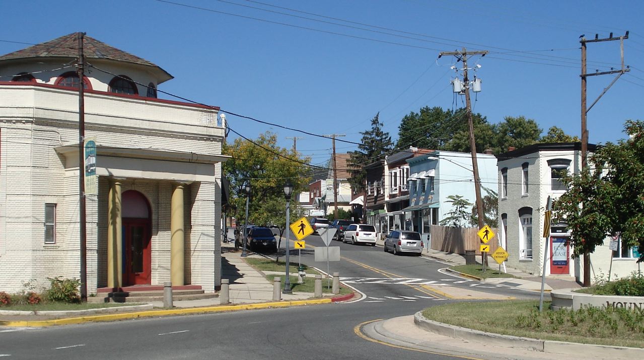
Mount Rainier Historic District
Monument and historic site · National Register of Historic Places · 2.1 mi
Historic district located in Mount Rainier, Maryland

Adams Memorial
Monument and historic site · National Register of Historic Places · 2.1 mi
Artwork by Augustus Saint-Gaudens
Alexander Crummell School
Monument and historic site · National Register of Historic Places · 3.7 mi
Historic school building in Washington, DC
Andrew Rankin Memorial Chapel, Frederick Douglas Memorial Hall, Founders Library
Monument and historic site · National Register of Historic Places · 3.8 mi
Library
Armed Forces Retirement Home-Washington
Monument and historic site · National Register of Historic Places · 2.7 mi
United States historic place
Ash Hill
Monument and historic site · National Register of Historic Places · 1.4 mi
House in Hyattsville, Maryland, United States
Banneker Recreation Center
Monument and historic site · National Register of Historic Places · 3.8 mi
Historic recreation center in Washington, D.C., United States


Battleground National Cemetery
Monument and historic site · National Register of Historic Places · 2.6 mi
American Civil War burial ground of Union Army soldiers in Washington, D.C., US
Blanche Kelso Bruce Elementary School
Monument and historic site · National Register of Historic Places · 3.6 mi
All-black school and community center during the Jim Crow era in the United States
Bostwick
Monument and historic site · National Register of Historic Places · 3.1 mi
Historic home located at Bladensburg
Boulder Bridge and Ross Drive Bridge
Monument and historic site · National Register of Historic Places · 3.8 mi
Bridges in Washington, D.C.
Brooks Mansion
Monument and historic site · National Register of Historic Places · 2.5 mi
Greek Revival plantation house
64 more on the map.
Parks, trails and playgrounds63

Acorn Park
Park · 3.1 mi
City park featuring a unique, acorn-shaped gazebo surrounded by tree-topped walkways in Silver Spring, Maryland, United States
Bladensburg Dueling Grounds
Park · 3.5 mi
Site where more than 50 duels were fought during the 1800s in Maryland, US
McMillan Sand Filtration Site
Park · 3.4 mi
Twenty-five acre decommissioned water treatment plant in Northwest Washington, D.C., United States
51 more on the map.
Restaurants and cafes118

Carolina Kitchen Bar & Grill
Restaurant · Regional · 1.5 mi
6501 America Boulevard, Hyattsville
Su-Th 11:00-22:00, Fr-Sa 11:00-24:00
Cocineros
Restaurant · Latin American · 1.1 mi
3513 East-West Highway, Hyattsville
Mo-Th 11:00-21:00; Fr 11:00-22:00; Sa-Su 10:00-22:00
Full Yum 2
Restaurant · Chinese · 1.4 mi
4940 South Dakota Avenue Northeast, Washington
Mo-Th 11:00-21:30; Fr-Sa 11:00-22:00; Su 12:00-21:30
Kin Da
Restaurant · Thai, Sushi · 1.9 mi
6923 Laurel Avenue, Takoma Park
Tu-Fr 11:30-15:00,17:00-20:15; Sa,Su 12:00-15:00,16:30-20:15
Los Pollos Silvestres
Restaurant · Latin American · 0.8 mi
5922 Riggs Road, Hyattsville
Mo-Sa 11:00-21:00
Mid Atlantic Seafood
Restaurant · Chicken, Seafood, Soul Food · 1.2 mi
6500 New Hampshire Avenue, Takoma Park
Mo-Th 07:30-20:30; Fr-Sa 07:30-21:00; Su off
Mid Atlantic Seafood
Restaurant · Fish · 1.3 mi
3100 Queens Chapel Road, Hyattsville
Mo-Th,Sa 10:00-21:00; Fr 10:00-21:30; Su 11:00-21:00

Old Dominion Brew House
Bar and pub · American · 1.4 mi
6404 America Boulevard, Hyattsville
Su-Tu 11:00-23:00, We 11:00-24:00, Th 11:00-23:00, Fr-Sa 11:00-24:00
Outback Steakhouse
Restaurant · American, Steak · 1.2 mi
3500 East-West Highway, Hyattsville
Mo-Th 11:00-22:00; Fr,Sa 11:00-23:00; Su 11:00-21:00
Pizza Movers
Restaurant · Pizza · 1.9 mi
6901 Laurel Avenue, Takoma Park
Mo-Th,Su 11:00-22:00; Fr-Sa 11:00-23:00
Roscoe's Neapolitan Pizzeria
Restaurant · Pizza · 1.8 mi
7040 Carroll Avenue, Takoma Park
Mo-Th 12:00-21:00; Fr,Sa 12:00-22:00; Su 11:00-21:00
106 more on the map.
History
Chillum takes its name from "Chillum Castle Manor," the 4,443-acre (17.98 km2) land patent established in 1763, by William Dudley Digges. It included lands in the present-day District of Columbia and in Prince George's County, and was composed of previously established land patents such as Henrietta Maria, Widows Purchase, Yarrow and Yarrow Head. Chillum Castle Manor was named after Chilham Castle, the old home of Sir Dudley Digges, an ancestor of William Dudley Digges, in Kent, England.
The manor house for the Henrietta Maria parcel was named Green Hill. It was home to William Dudley Digges and was the place where Pierre L'Enfant, designer of nearby Washington, D.C., died in destitution in 1825. He remained buried at the Green Hill property until being re-interred at Arlington National Cemetery in 1909. The Green Hill plantation was subsequently purchased by George Washington Riggs, who built the present Green Hill historic home in 1868.
From the History section of Chillum, Maryland on Wikipedia, under CC BY-SA 4.0.
Where to stay3
Churches and places of worship60
Kingdom Hall of Jehovah’s Witnesses
Place of worship · Jehovahs Witness · 0.5 mi
6517 Truman Road, Hyattsville
Union Wesley African Methodist Episcopal Zion Church
Church · African Methodist Episcopal Zion · 1.4 mi
1860 Michigan Avenue Northeast, Washington
Shopping35
Gas and EV charging24
Schools, colleges and libraries97
Lamond-Riggs/Lillian J. Huff Neighborhood Library
Library · 1.4 mi
5401 South Dakota Avenue Northeast, Washington
Washington Adventist University
School · Seventh Day Adventist · 1.8 mi
7600 Flower Avenue, Takoma Park
Institute of Our Lady of Mount Carmel Child Development Center (scrilli)
School · Catholic · 1.8 mi
4407 8th Street Northeast
Healthcare16
Rehabilitation & Specialized Care - Bunker Hill Road
Hospital · 1.7 mi
1731 Bunker Hill Road Northeast, Washington
Ramdass Pharmacy
Clinic and pharmacy · 1.4 mi
475 Ingraham Street Northeast, Washington
Prince George's Medical Center
Clinic and pharmacy · 1.4 mi
6525 Belcrest Road, Hyattsville
1Stop Primary Urgent Care
Clinic and pharmacy · 1.2 mi
6401 New Hampshire Avenue, Hyattsville
Fresenius Kidney Care
Clinic and pharmacy · 1.8 mi
6411 Chillum Place Northwest, Washington
Map of Chillum
250 places. The map loads OpenStreetMap tiles when you open it.
Climate by month
Monthly table
| Month | High | Low | Rain | Snow |
|---|---|---|---|---|
| Jan | 45°F | 28°F | 3.0 in | 4.7 in |
| Feb | 48°F | 30°F | 2.8 in | 2.3 in |
| Mar | 56°F | 36°F | 4.0 in | 1.4 in |
| Apr | 68°F | 46°F | 3.4 in | 0.0 in |
| May | 77°F | 57°F | 4.3 in | 0.0 in |
| Jun | 85°F | 66°F | 4.6 in | 0.0 in |
| Jul | 90°F | 71°F | 4.6 in | 0.0 in |
| Aug | 88°F | 69°F | 3.7 in | 0.0 in |
| Sep | 82°F | 62°F | 4.1 in | 0.0 in |
| Oct | 70°F | 49°F | 4.2 in | 0.0 in |
| Nov | 58°F | 39°F | 3.2 in | 0.0 in |
| Dec | 49°F | 32°F | 3.7 in | 1.3 in |
U.S. Climate Normals 1991-2020 for Natl Arboretum Dc (4 mi away), NOAA NCEI.
People and cost of living
American Community Survey 5-year estimates, 2020-2024, U.S. Census Bureau. Estimates have margins of error, larger for small towns.
Disaster history
Prince George's County has had 13 federal disaster declarations since 2000, most often for hurricanes.
- 2026-01-24: Severe Winter Storm (Winter Storm)
- 2020-03-26: Covid-19 Pandemic (Biological)
- 2020-03-13: Covid-19 (Biological)
- 2016-03-04: Severe Winter Storm And Snowstorm (Snowstorm)
- 2012-11-20: Hurricane Sandy (Hurricane)
- 2012-10-28: Hurricane Sandy (Hurricane)
OpenFEMA disaster declarations summaries.
Getting there and nearby towns
College Park Airport (CGS) is the nearest airport with scheduled flights listed in OpenStreetMap, 3 miles away.
- Adelphi 2 mi north, about 4 min by car
- Washington 5 mi southwest, about 8 min by car
- Beltsville 6 mi northeast, about 10 min by car
- Calverton 6 mi north, about 10 min by car
- Bethesda 8 mi west, about 12 min by car
- Arlington 9 mi southwest, about 14 min by car
- Aspen Hill 10 mi northwest, about 17 min by car
- Burtonsville 11 mi north, about 18 min by car
- Alexandria 12 mi southwest, about 19 min by car
- Camp Springs 12 mi south, about 19 min by car
Drive times are estimates from straight-line distance, not routes.
Local news
Headlines from INDB, the NEMICO news database.
Reviews, tips and questions
Loading what members have shared...
Sources and licences
- NCES EDGE (Public domain): public schools
- NOAA NCEI U.S. Climate Normals 1991-2020 (Public domain): climate by month
- OpenFEMA (Public domain): disaster declarations
- OpenStreetMap contributors (ODbL 1.0): places, airports, map data
- U.S. Census Bureau (Public domain): population, income, housing, education, commute
- Wikidata (CC0 1.0): elevation, founding date, time zone, website, landmarks and historic places
- Wikimedia Commons (see each image): photos
- Wikipedia (CC BY-SA 4.0): overview and history text
Photo credits
- Sligo Creek - panoramio, Ron Alford, CC BY-SA 3.0
- 2016-09-13 16 31 23 View east along Maryland State Route 410 (East-West Highway) at Maryland State Route 212 (Riggs Road) in Chillum, Prince Georges County, Maryland, Famartin, CC BY-SA 4.0
- 2020-08-19 10 50 02 View south along Maryland State Route 212 (Riggs Road) at Maryland State Route 410 (East-West Highway) in Chillum, Prince George's County, Maryland, Famartin, CC BY-SA 4.0
- 2017-06-03 09 40 44 View south along Maryland State Route 964 (Truman Road) at Red Top Road in Chillum, Prince George's County, Maryland, Famartin, CC BY-SA 4.0
- 2017-06-03 09 42 50 View north along Maryland State Route 964 (Truman Road) at Red Top Road in Chillum, Prince George's County, Maryland, Famartin, CC BY-SA 4.0
- 2017-06-03 09 41 28 View north at the south end of Maryland State Route 964 (Truman Road) in Chillum, Prince George's County, Maryland, Famartin, CC BY-SA 4.0
- 2020-08-19 12 01 02 View north along Maryland State Route 212 (Riggs Road) at Maryland State Route 410 (East-West Highway) in Chillum, Prince George's County, Maryland, Famartin, CC BY-SA 4.0
- Saint John Baptist de la Salle Church (Chillum, Maryland), Farragutful, CC BY-SA 3.0
- 2016-09-05 14 11 36 View west along Maryland State Route 501 (Chillum Road) at Sargent Road (former Maryland State Route 211) in Chillum, Prince Georges County, Maryland, Famartin, CC BY-SA 4.0
- 2020-08-19 11 52 22 View west along Maryland State Route 501 (Chillum Road) at Sargent Road in Chillum, Prince George's County, Maryland, Famartin, CC BY-SA 4.0
- 2020-08-19 11 02 01 View east along Maryland State Route 501 (Chillum Road) at Sargent Road in Chillum, Prince George's County, Maryland, Famartin, CC BY-SA 4.0
- 2016-09-02 13 36 17 View east along Maryland State Route 501 (Chillum Road) at Maryland State Route 212 (Riggs Road) in Chillum, Prince Georges County, Maryland, Famartin, CC BY-SA 4.0
- HMS Richards Hall - WAU, Farragutful, CC BY-SA 3.0
- US Route 1 & 34th St, Mt. Rainier, Maryland, Nonvirtual, CC BY-SA 3.0
- Takoma Park hd, Farragutful, CC BY-SA 3.0
- George M. Lightfoot House, Farragutful, CC BY-SA 3.0
- SS B&O Station 2, Farragutful, CC BY-SA 3.0
- Battleground Cemetery, D Monack at English Wikipedia, Public domain
- Entrance - Glenwood Cemetery - 2014-09-14, Tim1965, CC BY-SA 4.0
- National Home for Destitute Colored Women and Children, Farragutful, CC BY-SA 4.0
- Lowell School DC, Kesasummers, Public domain
- St. Paul's Church, Cliff, CC BY 2.0
- Petworth Branch Library, Farragutful, CC BY-SA 4.0
- Pool Safely mini-beach balls at WLSL (9077724594), PoolSafely, CC BY 2.0
- Pool Safely materials at WLSL (9077724252), PoolSafely, CC BY 2.0
- Under Ager Rd - panoramio, Ron Alford, CC BY-SA 3.0
- 2019-06-11 12 55 06 View east along Maryland State Route 410 (East-West Highway) just west of Toledo Terrace in Hyattsville, Prince George's County, Maryland, Famartin, CC BY-SA 4.0
- Northwest Branch Trail - panoramio, Ron Alford, CC BY-SA 3.0
- Sligo Creek and the Northwest Branch, Bruce Andersen, CC BY-SA 4.0
- Thaumatomyia glabra 140683356, Katja Schulz, CC BY 4.0
- Thaumatomyia glabra 140683345, Katja Schulz, CC BY 4.0
- Phragmidium rubi-idaei (53), Katja Schulz, CC BY 4.0
- Eristalis transversa 163213486, Katja Schulz, CC BY 4.0
- Eristalis transversa 163213480, Katja Schulz, CC BY 4.0
- Dioxyna picciola 101289105, Katja Schulz, CC BY 4.0
- Epicauta pensylvanica 163893080 (cropped), Katja Schulz, CC BY 4.0
- Epicauta pensylvanica 163893080, Katja Schulz, CC BY 4.0
- Xiphydria abdominalis, Carrie Seltzer, CC BY 4.0
- Safeway Signature Cafe corn chowder, Elvert Barnes, CC BY-SA 2.0
- Mycodiplosis (18), Katja Schulz, CC BY 4.0


Page built October 30, 2026. Spotted a mistake? Tell us or suggest a place.