


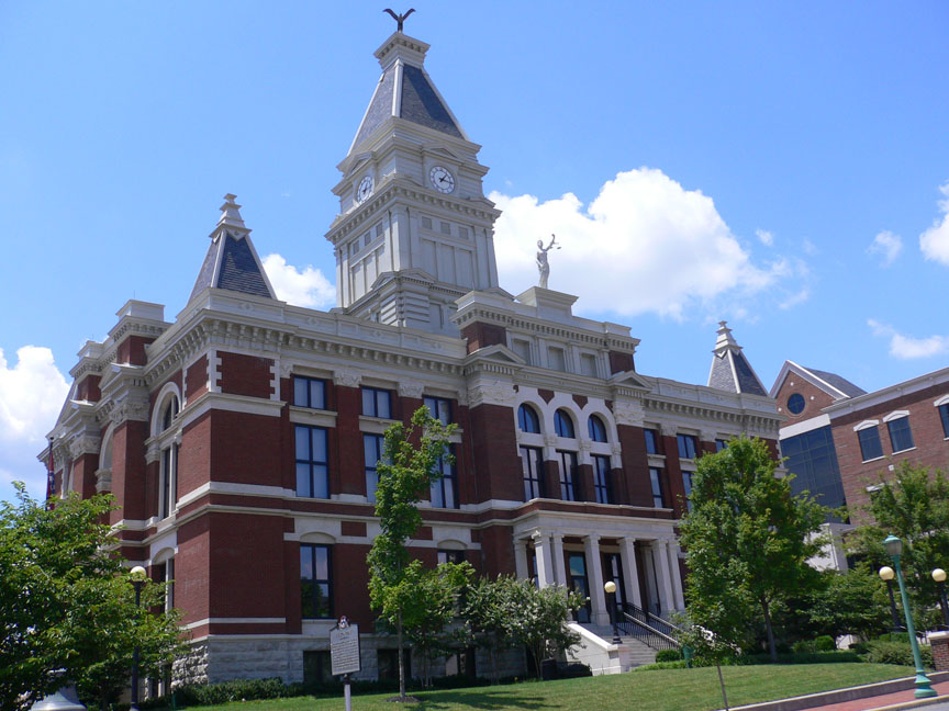

Clarksville, Tennessee
Clarksville is a city of 176,456 people in Montgomery County, Tennessee, founded in 1785.
Why visit Clarksville
Townapedia lists 29 museums and landmarks, 42 parks and trails, 273 places to eat, 34 places to stay and 8 attractions in and around town.
Highlights include Roxy Regional Theatre, AMC Governor's Square 10, Customs House Museum and Montgomery County Government.
July is the warmest month, with average highs of 90°F; January lows average 28°F.
Weather in Clarksville
Forecast from the National Weather Service. Full forecast
About Clarksville
Clarksville is a city in Montgomery County, Tennessee, United States, its county seat, and only incorporated municipality. The city had a population of 166,722 as of the 2020 census, making it the fifth-most populous city in Tennessee. It is the principal city of the Clarksville metropolitan area, which consists of Montgomery and Stewart counties in Tennessee and Christian and Trigg counties in Kentucky.
From the Wikipedia article Clarksville, Tennessee (this version), under CC BY-SA 4.0.
Things to do8

Roxy Theatre
Cinema and theater · 2.8 mi
Theater and former movie theater in Clarksville, Tennessee, United States
Clarksville Stadium 16 & RPX
Cinema and theater · 4.2 mi
1810 TinyTown Road, Clarksville


Cash and Carry Barn
Farm and orchard · 5.5 mi
Small sotre selling many handmade items and food, as well as firewood and locally harvested seasonal fruits and vegatables.
1003 Lafayette Road, Clarksville
Museums and landmarks29

Customs House Museum
Museum · 2.9 mi
200 South 2nd Street, Clarksville
Tu-Sa 10:00-17:00; Su 13:00-17:00
Montgomery County Government
Monument and historic site · 2.8 mi
1 Millenium Plaza, Clarksville
Mo-Fr 07:30-16:30

Alfred A. Robb House
Monument and historic site · National Register of Historic Places · 2.2 mi
Historic house in Clarksville, Tennessee
Allen House
Monument and historic site · National Register of Historic Places · 2.9 mi
Historic house in Clarksville, Tennessee
Christopher H. Smith House
Monument and historic site · National Register of Historic Places · 2.4 mi
Historic house in Tennessee, United States
Customs House Museum and Cultural Center
Monument and historic site · National Register of Historic Places · 2.9 mi
Clarksville, Tennessee, former customs house and former post office
Emerald Hill
Monument and historic site · National Register of Historic Places · 2.6 mi
Mansion in Clarksville, Tennessee
Forbes-Mabry House
Monument and historic site · National Register of Historic Places · 2.3 mi
House in Clarksville, United States of America
Glen Burnie
Monument and historic site · National Register of Historic Places · 8.5 mi
House in Christian County, Kentucky
Johnson-Hach House
Monument and historic site · National Register of Historic Places · 2.9 mi
House in Clarksville, United States of America
Madison Street Historic District
Monument and historic site · National Register of Historic Places · 2.9 mi
Listed on the National Register of Historic Places
Northington-Beach House
Monument and historic site · National Register of Historic Places · 2.8 mi
House in Clarksville, United States of America
17 more on the map.
Parks, trails and playgrounds42





30 more on the map.
Restaurants and cafes273

Applebee's
Diner · American · 3.8 mi
3066 Wilma Rudolph Boulevard, Clarksville
11:00-24:00, Fr 11:00-01:00

BaoBao Braised Chicken
Restaurant · Chicken · 3.6 mi
1661B Fort Campbell Boulevard, Clarksville
11:00-22:00

Chi-Town Hot Dogs
Restaurant · Hot Dog · 4.0 mi
1057 South Riverside Drive, Clarksville
Mo-Fr 10:30-19:00; Sa 11:00-16:00
Chuck E. Cheese
Restaurant · Pizza · 3.5 mi
2821B Wilma Rudolph Boulevard, Clarksville
Mo-Su 11:00-21:00; Fr 11:00-22:00; Sa 09:00-22:00
Cowboy's Steakhouse
Restaurant · Steak House · 4.1 mi
549 Dover Road, Clarksville
Mo-Th 11:00-21:00; Fr 11:00-23:00; Sa 10:00-23:00; Su 10:00-19:30
Cracker Barrel
Diner · American · 4.4 mi
200 Cracker Barrel Drive, Clarksville
Mo-Th 06:00-22:00; Fr-Sa 06:00-23:00; Su 06:00-22:00
Dae Bok Chop House
Restaurant · Korean · 4.2 mi
1949 C Fort Campbell Boulevard, Clarksville
Mo-Sa 10:00-20:30
Edward's Steakhouse
Restaurant · Steak House · 2.8 mi
107 Franklin Street, Clarksville
Tu-Sa 16:30-22:00
261 more on the map.
Where to stay34
Churches and places of worship62
First Presbyterian Church
Church · Presbyterian · National Register of Historic Places · 2.7 mi
313 Main Street, Clarksville
St. Peter African Methodist Church
Church · Methodist · National Register of Historic Places · 2.7 mi
Bethlehem Methodist Church and Cemetery
Church · National Register of Historic Places · 8.0 mi
Catholic Church and Rectory
Church · National Register of Historic Places · 2.6 mi
Clarksville Methodist Church
Church · National Register of Historic Places · 2.6 mi
First Presbyterian Church Manse
Church · National Register of Historic Places · 2.6 mi
Trinity Church and Rectory
Church · National Register of Historic Places · 2.7 mi
Shopping53
Gas and EV charging40
Tesla Supercharger
EV charging · 3.5 mi
2819 Wilma Rudolph Boulevard, Clarksville
Schools, colleges and libraries73
Healthcare20
Matthew Walker Comprehensive Health Clinic
Clinic and pharmacy · 3.2 mi
230 D Dover Road, Clarksville
Urgent Care
Clinic and pharmacy · 2.9 mi
1193 Fort Campbell Boulevard, Clarksville
Map of Clarksville
250 places. The map loads OpenStreetMap tiles when you open it.
Climate by month
Monthly table
| Month | High | Low | Rain | Snow |
|---|---|---|---|---|
| Jan | 47°F | 28°F | 4.0 in | 0.3 in |
| Feb | 52°F | 31°F | 4.5 in | 0.1 in |
| Mar | 61°F | 38°F | 4.8 in | 0.1 in |
| Apr | 72°F | 47°F | 5.0 in | 0.0 in |
| May | 79°F | 57°F | 5.6 in | 0.0 in |
| Jun | 87°F | 65°F | 4.7 in | 0.0 in |
| Jul | 90°F | 69°F | 4.6 in | 0.0 in |
| Aug | 90°F | 67°F | 3.7 in | 0.0 in |
| Sep | 84°F | 60°F | 3.4 in | 0.0 in |
| Oct | 72°F | 48°F | 4.3 in | 0.0 in |
| Nov | 60°F | 37°F | 4.1 in | 0.0 in |
| Dec | 50°F | 31°F | 4.9 in | 0.0 in |
U.S. Climate Normals 1991-2020 for Clarksville Wwtp Hcn (1 mi away), NOAA NCEI.
People and cost of living
American Community Survey 5-year estimates, 2020-2024, U.S. Census Bureau. Estimates have margins of error, larger for small towns.
Disaster history
Montgomery County has had 18 federal disaster declarations since 2000, most often for severe storms.
- 2026-02-06: Severe Winter Storm (Winter Storm)
- 2026-01-24: Severe Winter Storm (Winter Storm)
- 2025-06-19: Severe Storms, Straight-Line Winds, Tornadoes, And Flooding (Severe Storm)
- 2025-04-02: Severe Storms, Straight-Line Winds, Tornadoes, And Flooding (Severe Storm)
- 2024-06-17: Severe Storms, Tornadoes, And Flooding (Severe Storm)
- 2023-12-13: Severe Storms And Tornadoes (Severe Storm)
OpenFEMA disaster declarations summaries.
Getting there and nearby towns
Outlaw Field (CKV) is the nearest airport with scheduled flights listed in OpenStreetMap, 6 miles away.
- Oak Grove 9 mi northwest, about 14 min by car
- Fort Campbell North 10 mi northwest, about 16 min by car
- Guthrie 12 mi northeast, about 19 min by car
- Trenton 12 mi northeast, about 19 min by car
- Pembroke 14 mi north, about 23 min by car
- Adams 16 mi east, about 25 min by car
- Hopkinsville 20 mi north, about 32 min by car
- Elkton 20 mi northeast, about 32 min by car
- Pleasant View 21 mi southeast, about 33 min by car
- Nashville-Davidson 41 mi southeast, about 1 h by car
Drive times are estimates from straight-line distance, not routes.
Local news
Headlines from INDB, the NEMICO news database.
Reviews, tips and questions
Loading what members have shared...
Sources and licences
- NCES EDGE (Public domain): public schools
- NOAA NCEI U.S. Climate Normals 1991-2020 (Public domain): climate by month
- OpenFEMA (Public domain): disaster declarations
- OpenStreetMap contributors (ODbL 1.0): places, airports, map data
- U.S. Census Bureau (Public domain): population, income, housing, education, commute
- Wikidata (CC0 1.0): elevation, founding date, time zone, website, landmarks and historic places
- Wikimedia Commons (see each image): photos
- Wikipedia (CC BY-SA 4.0): overview and history text
Photo credits
- ClarksvilleTN VisitorCenter, Jugarum of English Wikipedia, CC BY-SA 3.0
- Austin Peay Browning Building, Riffsyphon1024 ( talk ), CC BY-SA 3.0
- St. Peter's AME Church 01, Sbugsyk, CC BY-SA 3.0
- Side picture, Sbugsyk, CC BY-SA 3.0
- ClarksvilleCourt2, Jugarum of English Wikipedia, CC BY-SA 3.0
Page built October 30, 2026. Spotted a mistake? Tell us or suggest a place.