



Why visit Wulingyuan
Townapedia lists 38 museums and landmarks, 8 parks and trails, 12 places to eat, 35 places to stay and 59 attractions in and around town.
Highlights include Wulingyuan, Wulingyuan Scenic and Historic Interest Area and Zhangjiajie National Forest Park.
Weather in Wulingyuan
Forecast from MET Norway (CC BY 4.0). Full forecast
About Wulingyuan
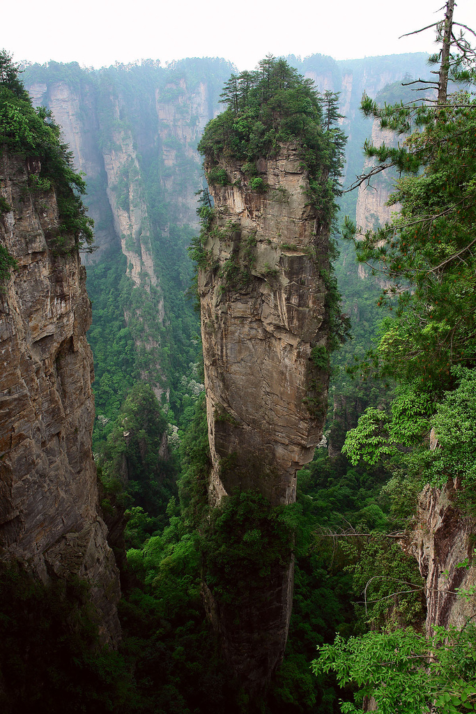
Wulingyuan ([ù.lǐŋ.ɥɛ̌n], Chinese: 武陵源) is a scenic and historical site in the Wulingyuan District of South Central China's Hunan Province. It is noted for more than 3,000 quartzite sandstone pillars and peaks across most of the site, many over 200 metres (660 ft) in height, along with many ravines and gorges with picturesque streams, pools, lakes, rivers, and waterfalls. It features 40 caves, many with large calcite deposits and a natural bridge named Tianqiaoshengkong (meaning 'bridge across the sky'), which is one of the highest natural bridges in the world. The site also provides habitat for many vulnerable species, including the dhole, Asiatic black bear, and Chinese water deer.
From the Wikipedia article Wulingyuan (this version), under CC BY-SA 4.0.
Travel tips from other travellers: Wulingyuan on Wikivoyage (CC BY-SA 4.0).
Things to do59

47 more on the map.
Museums and landmarks38

Wulingyuan Scenic and Historic Interest Area
Monument and historic site · 8.0 km

Yuanjiazhai
Monument and historic site · 10.5 km
袁家寨子位于张家界武陵源核心景区,是袁家界风景区范围内唯一的一个是私人建筑,当地地主的寨子。
26 more on the map.
Parks, trails and playgrounds8


Zhangjiajie National Forest Park
Park · 12.7 km
Park in Hunan province in China




Restaurants and cafes12

Grimm & Cook house
Restaurant
Western style restaurant with meat, pizza, pasta and ice creams
Tianzi road
Mo-Su 11:55-09:55


Where to stay35
Bajie Youth Hostel (national forest park)
Motel and hotel · 11.8 km
zhangjiajie national forest park,zhangjiajie village, zhangjiajie
Zhangjiajie Xianlv Residential Accommodation
Motel and hotel · 12.5 km
398 Xiejiayu Road
Churches and places of worship2
Shopping1
Schools, colleges and libraries2
Map of Wulingyuan
157 places. The map loads OpenStreetMap tiles when you open it.
Getting there and nearby towns
Zhangjiajie Hehua International Airport (DYG) is the nearest airport with scheduled flights listed in OpenStreetMap, 29 km away.
- Zhangjiajie 25 km south, about 25 min by car
Drive times are estimates from straight-line distance, not routes.
Local news
Headlines from INDB.
Reviews, tips and questions
Loading what members have shared...
Sources and licences
- GeoNames (CC BY 4.0): population, coordinates, regions and time zone
- OpenStreetMap contributors (ODbL 1.0): places, airports, map data
- Wikidata (CC0 1.0): elevation, founding date, time zone, website, landmarks and historic places
- Wikimedia Commons (see each image): photos
- Wikipedia (CC BY-SA 4.0): overview and history text
Photo credits
- Wulingyuan bridge, Codas, CC BY-SA 4.0
- Yangjiajie, Yoo Chung, CC BY-SA 2.5
- 1 zhangjiajie huangshizhai wulingyuan panorama 2012, chensiyuan, CC BY-SA 4.0
- 湖南 张家界 百龙天梯 - panoramio (cropped), Nyx Ning, CC BY-SA 3.0
- Wulingyuan 3, John Philip, CC BY-SA 2.0
- 1 tianzishan wulingyuan zhangjiajie 2012, chensiyuan, CC BY-SA 4.0
- 湖南 张家界 百龙天梯 - panoramio, Nyx Ning, CC BY-SA 3.0
- China WP 20160816 001 (28645941403), Kuruman from Tokyo, Japan, CC BY 2.0
- China IMG 3944 (29707526966), Kuruman from Tokyo, Japan, CC BY 2.0
- China IMG 3945 (29707530076), Kuruman from Tokyo, Japan, CC BY 2.0
- China IMG 3855 (29118091213), Kuruman from Tokyo, Japan, CC BY 2.0
- China IMG 3943 (29707524896), Kuruman from Tokyo, Japan, CC BY 2.0
- China IMG 3946 (29707532606), Kuruman from Tokyo, Japan, CC BY 2.0
- China IMG 3947 (29707535346), Kuruman from Tokyo, Japan, CC BY 2.0
- China IMG 3948 (29707537626), Kuruman from Tokyo, Japan, CC BY 2.0
- China IMG 3859 (29118109953), Kuruman from Tokyo, Japan, CC BY 2.0
- China IMG 3857 (29118100603), Kuruman from Tokyo, Japan, CC BY 2.0
- China IMG 3858 (29118105523), Kuruman from Tokyo, Japan, CC BY 2.0
- China WP 20160814 007 (28643684404), Kuruman from Tokyo, Japan, CC BY 2.0
- China WP 20160814 008 (29188375591), Kuruman from Tokyo, Japan, CC BY 2.0
- China IMG 3856 (29118096113), Kuruman from Tokyo, Japan, CC BY 2.0
- China IMG 3949 (29707540056), Kuruman from Tokyo, Japan, CC BY 2.0
- China IMG 3942 (29451587800), Kuruman from Tokyo, Japan, CC BY 2.0
- China IMG 3950 (29118304163), Kuruman from Tokyo, Japan, CC BY 2.0
- China IMG 3951 (29118307753), Kuruman from Tokyo, Japan, CC BY 2.0
- China IMG 3952 (29118310813), Kuruman from Tokyo, Japan, CC BY 2.0
- China IMG 3953 (29118314793), Kuruman from Tokyo, Japan, CC BY 2.0
- China IMG 3954 (29118318923), Kuruman from Tokyo, Japan, CC BY 2.0
- China IMG 3555 (29446111480), Kuruman from Tokyo, Japan, CC BY 2.0
- China IMG 3847 (29631097332), Kuruman from Tokyo, Japan, CC BY 2.0
- China IMG 3955 (29118323803), Kuruman from Tokyo, Japan, CC BY 2.0
- China WP 20160813 002 (29266722135), Kuruman from Tokyo, Japan, CC BY 2.0
- China IMG 3957 (29118328603), Kuruman from Tokyo, Japan, CC BY 2.0
- China IMG 3941 (29451586100), Kuruman from Tokyo, Japan, CC BY 2.0
- China IMG 3175 (29625255372), Kuruman from Tokyo, Japan, CC BY 2.0
- China IMG 3176 (29736715655), Kuruman from Tokyo, Japan, CC BY 2.0
- Chairs 椅子 - panoramio, lienyuan lee, CC BY 3.0
- China IMG 3174 (29701056786), Kuruman from Tokyo, Japan, CC BY 2.0
- China WP 20160814 006 (28645884033), Kuruman from Tokyo, Japan, CC BY 2.0
- China IMG 3848 (29631099722), Kuruman from Tokyo, Japan, CC BY 2.0


Page built November 3, 2026. Spotted a mistake? Tell us or suggest a place.