
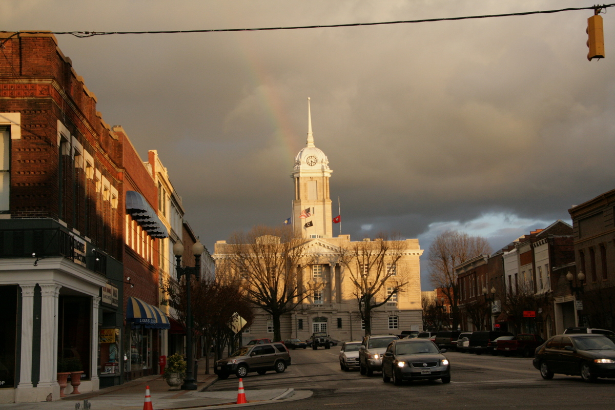


Columbia, Tennessee
Columbia is a city of 45,441 people in Maury County, Tennessee, founded in 1808.
Why visit Columbia
Townapedia lists 28 museums and landmarks, 16 parks and trails, 34 places to eat, 2 places to stay and 11 attractions in and around town.
Highlights include Foxall Hill, Golston Hill, Polk Home and Athenaeum.
July is the warmest month, with average highs of 89°F; January lows average 27°F.
Weather in Columbia
Forecast from the National Weather Service. Full forecast
About Columbia
Columbia is a city in and the county seat of Maury County, Tennessee. The population was 48,885 as of the City of Columbia's 2024 Special Census conducted by the US Census Bureau. Columbia is included in the Nashville metropolitan area.
From the Wikipedia article Columbia, Tennessee (this version), under CC BY-SA 4.0.
Things to do11

Museums and landmarks28


Athenaeum
Monument and historic site · National Register of Historic Places · 0.8 mi
Columbia, Tennessee, US

Beechlawn
Monument and historic site · National Register of Historic Places · 3.9 mi
Historic mansion in Tennessee, USA

Blythewood
Monument and historic site · National Register of Historic Places · 1.8 mi
Historic house in Tennessee, United States
Church Barrow House
Monument and historic site · 0.7 mi
Second Empire Architecture, National Historic Register 78002609
312 West 7th Street, Columbia

Church House
Monument and historic site · National Register of Historic Places · 0.8 mi
Mansion in Columbia, Tennessee
Clifton Place
Monument and historic site · National Register of Historic Places · 5.1 mi
Mansion in Columbia, Tennessee

Columbia Hydroelectric Station
Monument and historic site · National Register of Historic Places · 1.8 mi
Hydroelectric power station in Columbia, United States of America

Elm Springs
Monument and historic site · National Register of Historic Places · 2.9 mi
Historic building in Tennessee

Fairmont
Monument and historic site · National Register of Historic Places · 2.9 mi
Historic mansion in Columbia, Tennessee, USA


James K. Polk Ancestral Home
Monument and historic site · National Register of Historic Places · 0.8 mi
Historic house in Tennessee, United States
James Kennedy House
Monument and historic site · National Register of Historic Places · 3.5 mi
Historic house in Columbia, Tennessee, United States
16 more on the map.
Parks, trails and playgrounds16

Pillow Park
Park · 0.8 mi
Splash pad, and open grassy areas to play ball.
East 5th Street, Columbia


4 more on the map.
Restaurants and cafes34

Tennessee Coffee & Smoothie Co.
Cafe · Coffee Shop · 1.9 mi
1210 North Commerce Court, Columbia
Mo-Fr 05:00-18:00; Sa 07:00-18:00; Su 07:30-15:00


The Stubborn Mule
Restaurant · Regional · 2.4 mi
1511 Nashville Highway, Columbia
Mo-Su 07:00-14:00

Muletown Coffee Roasters
Cafe · 1.0 mi
23 Public Square, Columbia
Mo-Sa 06:00-18:00; Su off
Barino Italian Southern Eatery
Restaurant · Italian · 1.1 mi
1018 South Garden Street, Columbia
Big Shake's Nashville Hot Chicken
Restaurant · Chicken · 1.0 mi
822 South Main Street, Columbia
Legends Steakhouse
Restaurant · 2.6 mi
2401 Pulaski Highway, Columbia
22 more on the map.
History
A year after the organization of Maury County in 1807, Columbia was laid out in 1808 and lots were sold. The original town, on the south bank of the Duck River, consisted of four blocks. The town was incorporated in 1817.
Columbia was the site of Jackson College from 1837 until it was burned, along with most of Columbia, by Union troops during the American Civil War.
Columbia had five documented lynchings in the 20th century. In 1924 a black man was shot and killed in the courthouse after his sentence was commuted, by the brother of his victim. In 1927 and 1933, young black men were lynched in Maury County for alleged assaults against white women; the first, Henry Choate, was being held as a suspect when he was lynched, and was hanged from the courthouse. In 1933 Cordie Cheek, a black 17-year-old, was accused of raping a white girl. After a grand jury declined to indict him, he was abducted from Nashville by white men including law officials, and taken back to Columbia. There he was castrated and lynched by a white mob.
From the History section of Columbia, Tennessee on Wikipedia, under CC BY-SA 4.0.
Where to stay2
Churches and places of worship29
First United Methodist Church of Columbia
Church · National Register of Historic Places · 0.8 mi
St. John's Episcopal Church
Church · National Register of Historic Places · 6.4 mi
St. Peter's Episcopal Church
Church · National Register of Historic Places · 0.8 mi
Zion Presbyterian Church
Church · National Register of Historic Places · 6.0 mi
Harvest Baptist Church
Church · Independent Fundamental · 0.9 mi
4th Avenue, Columbia
Shopping17
Discount Plumbing And Electric Supply
Hardware store · 2.4 mi
1508 Nashville Highway
Gas and EV charging8
Schools, colleges and libraries26
Maury County Public Library
Library · 0.9 mi
211 West 8th Street;West Eighth Street, Columbia
Healthcare4
First Stop Urgent Care and Wound Center
Clinic and pharmacy · 1.7 mi
1218 Trotwood Avenue, Columbia
Map of Columbia
175 places. The map loads OpenStreetMap tiles when you open it.
Climate by month
Monthly table
| Month | High | Low | Rain | Snow |
|---|---|---|---|---|
| Jan | 48°F | 27°F | 4.6 in | 0.3 in |
| Feb | 52°F | 29°F | 5.1 in | 0.4 in |
| Mar | 62°F | 36°F | 5.4 in | 0.2 in |
| Apr | 71°F | 44°F | 5.1 in | 0.0 in |
| May | 79°F | 54°F | 5.2 in | 0.0 in |
| Jun | 86°F | 62°F | 5.0 in | 0.0 in |
| Jul | 89°F | 67°F | 4.8 in | 0.0 in |
| Aug | 88°F | 65°F | 4.1 in | 0.0 in |
| Sep | 83°F | 58°F | 4.2 in | 0.0 in |
| Oct | 72°F | 45°F | 3.8 in | 0.0 in |
| Nov | 60°F | 35°F | 3.9 in | 0.0 in |
| Dec | 51°F | 30°F | 5.6 in | 0.0 in |
U.S. Climate Normals 1991-2020 for Columbia 3 Wnw (3 mi away), NOAA NCEI.
People and cost of living
American Community Survey 5-year estimates, 2020-2024, U.S. Census Bureau. Estimates have margins of error, larger for small towns.
Disaster history
Maury County has had 15 federal disaster declarations since 2000, most often for severe storms.
- 2026-02-06: Severe Winter Storm (Winter Storm)
- 2026-01-24: Severe Winter Storm (Winter Storm)
- 2025-04-02: Severe Storms, Straight-Line Winds, Tornadoes, And Flooding (Severe Storm)
- 2024-06-17: Severe Storms, Tornadoes, And Flooding (Severe Storm)
- 2023-03-08: Severe Winter Storm (Winter Storm)
- 2021-05-08: Severe Storms, Tornadoes, And Flooding (Tornado)
OpenFEMA disaster declarations summaries.
Getting there and nearby towns
Maury County Airport (MRC) is the nearest airport with scheduled flights listed in OpenStreetMap, 9 miles away.
- Mount Pleasant 9 mi southwest, about 15 min by car
- Spring Hill 11 mi northeast, about 18 min by car
- Thompson's Station 15 mi northeast, about 24 min by car
- Lynnville 17 mi south, about 28 min by car
- Lewisburg 19 mi southeast, about 30 min by car
- Chapel Hill 20 mi east, about 31 min by car
- Franklin 23 mi northeast, about 36 min by car
- Brentwood 30 mi northeast, about 48 min by car
- Murfreesboro 38 mi northeast, about 1 h by car
- Nashville-Davidson 40 mi north, about 1 h by car
Drive times are estimates from straight-line distance, not routes.
Local news
Headlines from INDB, the NEMICO news database.
Reviews, tips and questions
Loading what members have shared...
Sources and licences
- NCES EDGE (Public domain): public schools
- NOAA NCEI U.S. Climate Normals 1991-2020 (Public domain): climate by month
- OpenFEMA (Public domain): disaster declarations
- OpenStreetMap contributors (ODbL 1.0): places, airports, map data
- U.S. Census Bureau (Public domain): population, income, housing, education, commute
- Wikidata (CC0 1.0): elevation, founding date, time zone, website, landmarks and historic places
- Wikimedia Commons (see each image): photos
- Wikipedia (CC BY-SA 4.0): overview and history text
Photo credits
- Columbia Tennessee Square, Flickr user jdj150, CC BY 2.0
- St. Peter's Episcopal Church Columbia Tennessee, Joe Elliott, CC BY-SA 3.0
- Zion Church (Presbyterian), State Route 1, Columbia vicinity (Maury County, Tennessee), . Jeter Eason, Deputy District Officer, Photographer, Public domain
- Church Barrow Locke House, Matt Locke, CC BY-SA 4.0
- POLK SISTERS' HOUSE, JERRYE & ROY KLOTZ MD, CC BY-SA 3.0
- JamesKPolkHome, ProhibitOnions at English Wikipedia, CC BY-SA 3.0
- Skipwith Hall House, rossograph, CC BY-SA 4.0
- Mayes-Hutton-House, Joe Elliott, CC BY-SA 3.0
- Athenaeum Columbia, Www78, CC BY-SA 3.0
- Union Station Columbia, Www78, CC BY-SA 3.0
- First United Methodist Church of Columbia Tennessee, Joe Elliott, CC BY-SA 3.0
- St. John's Church Columbia TN, Hal Jespersen, Public domain
- Mercer Hall, Columbia (Maury County, Tennessee), W. Jeter Eason, Deputy District Officer, Photographer, Public domain
- Columbia Hydroelectric Station, Joe Elliott, CC BY-SA 3.0
- PineHill1, Andrew F. Thornburg, CC BY-SA 4.0
- Rally Hill, rossograph, CC BY-SA 4.0
- Patrick Maguire House, rossograph, CC BY-SA 4.0
- Elm Springs, rossograph, CC BY-SA 4.0
- Fairmont, rossograph, CC BY-SA 4.0
- Blythewood, rossograph, CC BY-SA 4.0
- Old main at CMA, Jathoms, CC BY-SA 3.0


Page built October 30, 2026. Spotted a mistake? Tell us or suggest a place.