


Cottage Grove, Oregon
Cottage Grove is a city of 10,698 people in Lane County, Oregon, founded in 1887.
Why visit Cottage Grove
Townapedia lists 15 museums and landmarks, 18 parks and trails, 53 places to eat, 6 places to stay and 8 attractions in and around town.
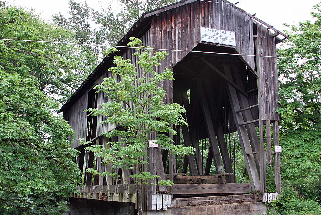
Highlights include Chambers Covered Bridge, Currin Bridge, Brumbaugh Bridge and Cochran-Rice Farm Complex.
August is the warmest month, with average highs of 83°F; December lows average 33°F.
Weather in Cottage Grove
Forecast from the National Weather Service. Full forecast
About Cottage Grove
Cottage Grove is a city in Lane County, Oregon, United States. Its population was 10,643 at the 2020 census. It is the third largest city in Lane County. It is on Interstate 5, Oregon Route 99, and the main Willamette Valley line of the CORP railroad.
From the Wikipedia article Cottage Grove, Oregon (this version), under CC BY-SA 4.0.
Things to do8

Chambers Covered Bridge
Bridge · National Register of Historic Places · 0.6 mi
Historic bridge in Cottage Grove, Oregon, USA

Currin Bridge
Bridge · National Register of Historic Places · 3.1 mi
Bridge in United States of America

Stewart Bridge
Bridge · National Register of Historic Places · 3.8 mi
Listed on the NRHP in Oregon
Centennial Covered Bridge
Bridge · 0.4 mi
Covered bridge in Oregon, US

Blackberry Food Co-op
Farm and orchard
926 East Main Street, Cottage Grove
Mo-Fr 12:00-18:00; Sa, Su 10:30-16:00

The Perry Patch
Farm and orchard · 0.6 mi
1121 South 4th Street, Cottage Grove
09:00-21:00

Museums and landmarks15

Brumbaugh Bridge
Monument and historic site · National Register of Historic Places · 1.7 mi
Covered bridge in Lane County in the U.S. state of Oregon

Cochran-Rice Farm Complex
Monument and historic site · National Register of Historic Places · 0.7 mi
Cottage Grove, Oregon, listed on the NRHP in Lane County, Oregon

Horace J. and Ann S. Shinn Cottage
Monument and historic site · National Register of Historic Places · 0.6 mi
Historic house in Oregon, United States


Mosby Creek Bridge
Bridge · National Register of Historic Places · 2.9 mi
Bridge in United States of America

Chambers Railroad Bridge
Monument and historic site · 0.8 mi
National Register of Historic Places # 79002081
Oregon Aviation Historical Society & Museum
Museum · 1.0 mi
2475 Thornton Lane, Cottage Grove
Tu 10:00-15:00; Fr 10:00-15:00
Cottage Grove Downtown Commercial Historic District
Monument and historic site
National Register of Historic Places # 93001568
Dr. Snapp House
Monument and historic site · 0.6 mi
360 South River Road, Cottage Grove
3 more on the map.
Parks, trails and playgrounds18


Prospector Park
Park · 0.6 mi
360 South River Road, Cottage Grove
Su-Sa 06:00-22:00
Silk Creek Park
Park · 0.6 mi
301 South River Road, Cottage Grove
Mo-Su 06:00-22:00
Hidden Valley Golf Course
Golf course · 0.7 mi
765 North River Road, Cottage Grove

Trailhead Park
Hiking and trails
1000 East Main Street, Cottage Grove
6 more on the map.
Restaurants and cafes53

Bonanza Drive-In
Restaurant · Burger, American, Ice Cream
505 Highway 99, Cottage Grove
Tu-Sa 11:00-20:00
El Tapatio
Restaurant · Mexican
725 East Gibbs Avenue, Cottage Grove
Mo-Th 11:00-22:00; Fr,Sa 11:00-23:00; Su 09:00-20:00
Jack Sprats
Restaurant · American, Burger, Breakfast
510 East Main Street, Cottage Grove
Mo-Th, Su 11:00-19:00; Fr, Sa 11:00-20:00

Rally Coffee Bar
Cafe · Coffee Shop
1220 East Main Street, Cottage Grove
Mo-Fr 06:00-16:00; Sa,Su 07:00-15:00
San Sushi & Teriyaki
Restaurant · Sushi · 0.5 mi
60 North Gateway Boulevard, Cottage Grove
Mo-Sa 11:00-20:30


Axe and Fiddle
Bar and pub
657 East Main Street, Cottage Grove
Mo-Th 16:00-23:00; Fr-Sa 16:00-24:00; Su 14:00-22:00
Coast Fork Brewing's Brewstation
Bar and pub
104 South 6th Street, Cottage Grove
Mo-Th,Su 12:00-21:00; Fr,Sa 12:00-22:00
41 more on the map.
History
Cottage Grove post office was established in 1855 east of present-day Creswell. It was named by its first postmaster, G. C. Pearce, whose home was in an oak grove. In 1861, the office was moved to the present site of Saginaw; then in the late 1860s, to the southwesternmost part of present-day Cottage Grove, on the west bank of the Coast Fork Willamette River. When the Southern Pacific railroad was built through the area in the 1870s, Cottage Grove station was placed more than half a mile northeast of the post office, on the river's east side. This was the start of a neighborhood dispute that lasted for nearly 20 years. The people living near the post office did not want it moved to the railroad station, so a new office was established at the station with the name Lemati, a Chinook Jargon word that means "mountain". Lemati office ran from November 1893 to September 1894, but in March 1898 the Cottage Grove office was renamed Lemati, and ran that way until it was permanently renamed Cottage Grove in May 1898.
From the History section of Cottage Grove, Oregon on Wikipedia, under CC BY-SA 4.0.
Where to stay6
Churches and places of worship22
Our Lady of Perpetual Help Roman Catholic Church
Church · Roman Catholic · National Register of Historic Places · 0.4 mi
147 North H Street, Cottage Grove
First Presbyterian Church
Church · Presbyterian · National Register of Historic Places · 0.4 mi
216 South 3rd Street, Cottage Grove
Hope Fellowship - United Pentecostal Church
Church · Pentecostal · 0.4 mi
100 South Gateway Boulevard, Cottage Grove
Kingdom Hall of Jehovah's Witnesses
Church · Jehovahs Witness · 1.2 mi
2450 South 6th Street, Cottage Grove
Our Lady of Perpetual Hope Catholic Church
Church · Roman Catholic · 0.7 mi
1025 North 19th Street, Cottage Grove
Cottage Grove Seventh-day Adventist Church
Church · Seventh Day Adventist · 0.4 mi
820 South 10th Street, Cottage Grove
St. Andrews Episcopal Church
Church · Episcopal · 0.7 mi
1301 West Main Street, Cottage Grove
Shopping20
Gas and EV charging11
Schools, colleges and libraries14
Oak Park Christian School
School · Nazarene · 0.6 mi
152 South M Street, Cottage Grove
Our Lady of Perpetual Hope Preschool
School · Roman Catholic · 0.7 mi
1025 North 19th Street, Cottage Grove
Trinity Lutheran Preschool
School · Lutheran · 0.4 mi
675 South 7th Street, Cottage Grove
Healthcare6
Map of Cottage Grove
173 places. The map loads OpenStreetMap tiles when you open it.
Climate by month
Monthly table
| Month | High | Low | Rain | Snow |
|---|---|---|---|---|
| Jan | 48°F | 33°F | 6.6 in | 0.9 in |
| Feb | 52°F | 34°F | 4.9 in | 1.1 in |
| Mar | 56°F | 35°F | 5.2 in | 0.3 in |
| Apr | 61°F | 38°F | 4.5 in | 0.0 in |
| May | 68°F | 44°F | 3.1 in | 0.0 in |
| Jun | 73°F | 48°F | 1.7 in | 0.0 in |
| Jul | 82°F | 51°F | 0.4 in | 0.0 in |
| Aug | 83°F | 50°F | 0.5 in | 0.0 in |
| Sep | 76°F | 46°F | 1.5 in | 0.0 in |
| Oct | 64°F | 41°F | 3.8 in | 0.0 in |
| Nov | 53°F | 37°F | 6.8 in | 0.0 in |
| Dec | 47°F | 33°F | 7.6 in | 0.4 in |
U.S. Climate Normals 1991-2020 for Cottage Grove 2E Hcn (1 mi away), NOAA NCEI.
People and cost of living
American Community Survey 5-year estimates, 2020-2024, U.S. Census Bureau. Estimates have margins of error, larger for small towns.
Disaster history
Lane County has had 16 federal disaster declarations since 2000, most often for severe storms.
- 2026-04-07: Severe Storms, Straight-Line Winds, Flooding, Landslides, And Mudslides (Severe Storm)
- 2024-04-13: Severe Winter Storms, Straight-Line Winds, Landslides, And Mudslides (Severe Storm)
- 2023-01-27: Cedar Creek Fire (Fire)
- 2020-09-15: Wildfires And Straight-Line Winds (Fire)
- 2020-09-10: Wildfires (Fire)
- 2020-09-08: Holiday Farm Fire (Fire)
OpenFEMA disaster declarations summaries.
Getting there and nearby towns
Eugene Airport (EUG) is the nearest airport with scheduled flights listed in OpenStreetMap, 24 miles away.
- Creswell 9 mi north, about 15 min by car
- Dexter 14 mi northeast, about 23 min by car
- Trent 14 mi northeast, about 23 min by car
- Jasper 15 mi northeast, about 24 min by car
- Drain 16 mi southwest, about 25 min by car
- Lowell 16 mi northeast, about 26 min by car
- Eugene 18 mi north, about 29 min by car
- Springfield 18 mi north, about 29 min by car
- River Road 20 mi north, about 33 min by car
- Corvallis 55 mi north, about 1 h 30 min by car
Drive times are estimates from straight-line distance, not routes.
Local news
Headlines from INDB, the NEMICO news database.
Reviews, tips and questions
Loading what members have shared...
Sources and licences
- NCES EDGE (Public domain): public schools
- NOAA NCEI U.S. Climate Normals 1991-2020 (Public domain): climate by month
- OpenFEMA (Public domain): disaster declarations
- OpenStreetMap contributors (ODbL 1.0): places, airports, map data
- U.S. Census Bureau (Public domain): population, income, housing, education, commute
- Wikidata (CC0 1.0): elevation, founding date, time zone, website, landmarks and historic places
- Wikimedia Commons (see each image): photos
- Wikipedia (CC BY-SA 4.0): overview and history text
Photo credits
- Cottage Grove Historic District, Visitor7, CC BY-SA 3.0
- Chambers Covered Railroad Bridge Plaque in Cottage Grove, Oregon, Rick Obst, CC BY 4.0
- Centennial Bridge, Cottage Grove, OR (7327108708), Sandy Horvath-Dori from Grand Junction, CO, USA, CC BY 2.0
- Centennial Bridge Time Capsule in Cottage Grove, Oregon, Rick Obst, CC BY 4.0
- Chambers Covered Bridge - Cottage Grove OR 2006, Chris Phan from Glasgow, United Kingdom, CC BY 2.0
- Chambers Covered Bridge - Cottage Grove OR, Bruce Fingerhood from Springfield, Oregon, US, CC BY 2.0
- Chambers Covered Railroad Bridge, Cottage Grove, OR (7328150666), Sandy Horvath-Dori from Grand Junction, CO, USA, CC BY 2.0
- Our Lady of Perpetual Help Catholic Church (Cottage Grove, Oregon), Visitor7, CC BY-SA 3.0
- First Presbyterian Church (Cottage Grove, Oregon), Visitor7, CC BY-SA 3.0
- Stewart Bridge Walden OR, Chris Phan from Glasgow, United Kingdom, CC BY 2.0
- Mosby Creek Bridge, Chris Phan from Glasgow, United Kingdom, CC BY 2.0
- Cochran-Rice Farm Complex (Cottage Grove, Oregon), Visitor7, CC BY-SA 3.0
- Currin Bridge - Cottage Grove Oregon, Bruce Fingerhood from Springfield, Oregon, US, CC BY 2.0
- Horace J and Ann S Shinn Cottage (Cottage Grove, Oregon), Visitor7, CC BY-SA 3.0
- Buster S Main Street Cafe, Derald Grimwood, CC0
- Six-Stool Lunch Counter, Visitor7, CC BY-SA 3.0
- CB-CottageGrovePano-s, William Gorman, CC BY-SA 3.0
- Memorial plaque 9111, Chris Light, CC BY-SA 4.0
- Slabtown 9113, Chris Light, CC BY-SA 4.0
- Swinging bridge 9109, Chris Light, CC BY-SA 4.0
- Swinging bridge 9110, Chris Light, CC BY-SA 4.0
- Dr. Pierce Barn Demolition-3, Visitor7, CC BY-SA 3.0
- Dr. Pierce Barn Demolition-2, Visitor7, CC BY-SA 3.0
- Dr. Pierce Barn Demolition-1, Visitor7, CC BY-SA 3.0
- Stewart Bridge (7722856530), Sandy Horvath-Dori from Grand Junction, CO, USA, CC BY 2.0
- Stewart Bridge (7722858108), Sandy Horvath-Dori from Grand Junction, CO, USA, CC BY 2.0


Page built October 30, 2026. Spotted a mistake? Tell us or suggest a place.