


Creve Coeur, Illinois
Creve Coeur is a village of 4,621 people in Tazewell County, Illinois.
Why visit Creve Coeur
Townapedia lists 32 museums and landmarks, 16 parks and trails, 28 places to eat and 6 attractions in and around town.
Highlights include Madison Theatre, Bob Michel Bridge, Central National Bank Building and Downtown Peoria Historic District.
July is the warmest month, with average highs of 86°F; January lows average 18°F, and about 26 inches of snow fall in a normal year.
Weather in Creve Coeur
Forecast from the National Weather Service. Full forecast
About Creve Coeur
Creve Coeur is a village in Groveland Township, Tazewell County, Illinois, United States. As of the 2020 census, the village population was 4,934. Creve Coeur is a suburb of Peoria and is part of the Peoria, Illinois Metropolitan Statistical Area.
From the Wikipedia article Creve Coeur, Illinois (this version), under CC BY-SA 4.0.
Things to do6

Madison Theatre
Cinema and theater · National Register of Historic Places · 3.5 mi
Theater and former movie theater in Peoria, Illinois, United States

Bob Michel Bridge
Bridge · 2.8 mi
IL 40 over the Illinois River between Peoria & E. Peoria, Illinois

Bradley University
School · 3.8 mi
Private university in Peoria, Illinois

Cedar Street Bridge
Bridge · 2.3 mi
Bridge over Illinois River between Peoria & E. Peoria, Illinois

Murray Baker Bridge
Bridge · 3.1 mi
I-74 over Illinois River between Peoria & E. Peoria, Illinois

Shade-Lohmann Bridge
Bridge · 1.4 mi
Freeway bridge over the Illinois River in Illinois
Museums and landmarks32

Central National Bank Building
Monument and historic site · National Register of Historic Places · 3.3 mi
Building in downtown Peoria, Illinois
Downtown Peoria Historic District
Monument and historic site · National Register of Historic Places · 3.4 mi
Historic district in Illinois, United States

Grand Army of the Republic Memorial Hall
Monument and historic site · National Register of Historic Places · 3.5 mi
Historic meeting hall in downtown Peoria, Illinois, USA

Hotel Père Marquette
Monument and historic site · National Register of Historic Places · 3.5 mi
Hotel in downtown Peoria, Illinois

International Harvester Building
Monument and historic site · National Register of Historic Places · 2.6 mi
Historic building in Peoria, Illinois, United States

John C. Proctor Recreation Center
Museum · National Register of Historic Places · 3.0 mi
1913 building in Peoria, Illinois

Judge Jacob Gale House
Monument and historic site · National Register of Historic Places · 3.6 mi
Historic house in Illinois, United States

Kickapoo Building
Monument and historic site · National Register of Historic Places · 3.6 mi
Historic building in Peoria, Illinois, USA

Lincoln Branch Peoria Public Library
Monument and historic site · National Register of Historic Places · 2.7 mi
Carnegie library located at 1312 West Lincoln Avenue in Peoria, Illinois
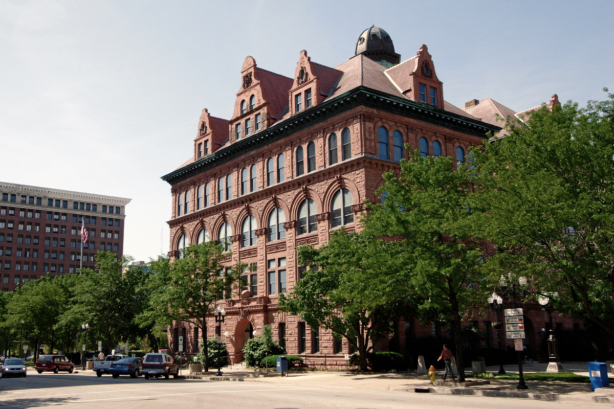
Peoria City Hall
Monument and historic site · National Register of Historic Places · 3.4 mi
City headquarters in downtown Peoria, Illinois, USA


Peoria Cordage Company
Monument and historic site · National Register of Historic Places · 2.6 mi
Building in Peoria, Illinois

Peoria Federal Building and U.S. Courthouse
Monument and historic site · National Register of Historic Places · 3.5 mi
U.S. government building and former post office in Peoria, Illinois
20 more on the map.
Parks, trails and playgrounds16


Marquette Heights Park
Park · 1.7 mi
300 LaSalle Boulevard, Marquette Heights
Mo-Su 06:00-23:00


4 more on the map.
Restaurants and cafes28


Lean Wang's
Restaurant · 1.8 mi
135 Radio City Drive, Pekin
Mo,Th,Fr 11:00-20:00; Tu,We,Sa 15:00-20:00; Su 11:30-20:00

Starbucks
Cafe · Coffee Shop · 1.9 mi
201 North Main Street, East Peoria
Mo-Fr 04:30-18:00; Sa-Su 05:00-18:00
Noodles & Company
Restaurant · Pasta · 2.0 mi
358 West Washington Street, East Peoria
Su-We 10:30-21:00; Th-Sa 10:30-22:00

The Silver Bullet
Bar and pub · American · 2.0 mi
135 North Main Street, East Peoria
Mo-Su 11:00-01:00
Main St Family Restaurant
Restaurant · Diner · 0.6 mi
620 South Main Street, Creve Coeur

Chick-fil-A
Fast food · Chicken · 1.9 mi
250 West Washington Street, East Peoria
Mo-Th 06:30-21:30; Fr-Sa 06:30-22:00; Su off
16 more on the map.
Churches and places of worship22
Cumberland Presbyterian Church
Church · National Register of Historic Places · 3.4 mi
Cathedral of Saint Mary of the Immaculate Conception
Church · 3.8 mi
BridgeWay Community Church
Church · Nazarene · 1.8 mi
106 Grant Road, Marquette Heights
Elm Ridge Missionary Baptist
Church · Baptist · 1.7 mi
737 Illinois Avenue, East Peoria
Saint Peter's Lutheran Church
Church · Lutheran · 1.7 mi
200 Cole Street, East Peoria
Shopping3
Gas and EV charging5
Schools, colleges and libraries56
Healthcare2
Map of Creve Coeur
170 places. The map loads OpenStreetMap tiles when you open it.
Climate by month
Monthly table
| Month | High | Low | Rain | Snow |
|---|---|---|---|---|
| Jan | 34°F | 18°F | 2.1 in | 7.7 in |
| Feb | 39°F | 21°F | 2.0 in | 6.9 in |
| Mar | 51°F | 32°F | 2.7 in | 3.3 in |
| Apr | 64°F | 42°F | 4.0 in | 0.5 in |
| May | 74°F | 53°F | 4.7 in | 0.0 in |
| Jun | 83°F | 62°F | 3.7 in | 0.0 in |
| Jul | 86°F | 66°F | 3.5 in | 0.0 in |
| Aug | 85°F | 64°F | 3.3 in | 0.0 in |
| Sep | 78°F | 56°F | 3.5 in | 0.0 in |
| Oct | 65°F | 44°F | 3.2 in | 0.1 in |
| Nov | 51°F | 33°F | 2.7 in | 1.5 in |
| Dec | 38°F | 23°F | 2.2 in | 6.2 in |
U.S. Climate Normals 1991-2020 for Peoria Gtr Peoria Ap Gsn 72532 (5 mi away), NOAA NCEI.
People and cost of living
American Community Survey 5-year estimates, 2020-2024, U.S. Census Bureau. Estimates have margins of error, larger for small towns.
Disaster history
Tazewell County has had 8 federal disaster declarations since 2000, most often for biologicals.
- 2020-03-26: Covid-19 Pandemic (Biological)
- 2020-03-13: Covid-19 (Biological)
- 2013-11-26: Severe Storms, Straight-Line Winds, And Tornadoes (Tornado)
- 2013-05-10: Severe Storms, Straight-Line Winds, And Flooding (Flood)
- 2011-03-17: Severe Winter Storm And Snowstorm (Snowstorm)
- 2006-12-29: Snow (Snowstorm)
OpenFEMA disaster declarations summaries.
Getting there and nearby towns
Peoria International Airport (PIA) is the nearest airport with scheduled flights listed in OpenStreetMap, 6 miles away.
- Bartonville 3 mi west, about 5 min by car
- East Peoria 4 mi northeast, about 6 min by car
- Pekin 5 mi south, about 9 min by car
- Bellevue 5 mi northwest, about 8 min by car
- Morton 7 mi east, about 12 min by car
- Peoria 8 mi north, about 12 min by car
- Washington 10 mi northeast, about 16 min by car
- Chillicothe 19 mi north, about 31 min by car
- Canton 24 mi west, about 38 min by car
- Normal 33 mi east, about 53 min by car
Drive times are estimates from straight-line distance, not routes.
Local news
Headlines from INDB, the NEMICO news database.
Reviews, tips and questions
Loading what members have shared...
Sources and licences
- NCES EDGE (Public domain): public schools
- NOAA NCEI U.S. Climate Normals 1991-2020 (Public domain): climate by month
- OpenFEMA (Public domain): disaster declarations
- OpenStreetMap contributors (ODbL 1.0): places, airports, map data
- U.S. Census Bureau (Public domain): population, income, housing, education, commute
- Wikidata (CC0 1.0): elevation, founding date, time zone, website, landmarks and historic places
- Wikimedia Commons (see each image): photos
- Wikipedia (CC BY-SA 4.0): overview and history text
Photo credits
- Shade-Lohmann Bridge, Creve Coeur, Illinois, Robert Guico, CC BY-SA 2.5
- Peoria State Hospital, Willjay, CC BY 3.0
- Francis W Little House I (Modified), mrknightgbs, CC BY 2.0
- Peoria Cordage Company Facade, Esvobod2, CC BY-SA 3.0
- Peoria - Downtown from Caterpillar, Courthouse Square, First National Bank and Savings Tower, Roger Wollstadt from Sarasota, Florida, CC BY-SA 2.0
- Image Lincoln Branch Peoria Public Library, Boscophotos, CC BY-SA 3.0
- Madison Theatre, Robert Lawton, CC BY-SA 2.5
- YWCA Building Peoria IL 9-27-2012 5-19-006, Searobin, CC BY-SA 3.0
- International Harvester Building Peoria, Esvobod2, CC BY-SA 3.0
- Image springs no longer open to the public on this property, Boscophotos, CC BY-SA 3.0
- John C Proctor Recreation Center Peoria, Esvobod2, CC BY-SA 3.0
- Pettingill-Morron House, Mmikhailova, CC BY-SA 3.0
- KickapooBldg, Jonathunder, GFDL 1.2
- Pere Marquette Hotel, Robert Lawton, CC BY-SA 2.5
- Cumberland Church Peoria 20231019 1229, NatFee, CC BY-SA 4.0
- Central National Bank Building, Esvobod2, CC BY-SA 3.0
- Peoria City Hall, Unknown author, CC BY-SA 2.5
- Peoria, IL train station, Ron Reiring, CC BY 2.0
- Judge Jacob Gale House, Mmikhailova, CC BY-SA 3.0
- Peoria 20231119 0211 GAR Hall, NatFee, CC BY-SA 4.0
- Image The Mill, located in Peoria Warehouse District, Boscophotos, CC BY-SA 3.0
- Marquette Apartments - Peoria Illinois, Ian Poellet, CC BY-SA 4.0
- Peace and Harvest Harvest, Esvobod2 ; sculptor Mary Andersen Clark, Public domain
- Murray Baker Bridge from riverside in East Peoria, Carsenegame, CC BY-SA 3.0
- 1stUMCPeoriaIL, Jonathunder, GFDL 1.2
- Bradley Hall, Bradley University, AscendedAnathema, CC BY-SA 3.0
- Cathedral of St. Mary Peoria Illinois, Farragutful, Public domain
- Cedar Street Bridge, Peoria, Illinois, Robert Guico, CC BY-SA 2.5
- Riverfront Museum Peoria 20231019 1132, NatFee, CC BY-SA 4.0
- Bob Michel Bridge, Peoria, Illinois, Robert Guico, CC BY-SA 2.5


Page built October 30, 2026. Spotted a mistake? Tell us or suggest a place.