
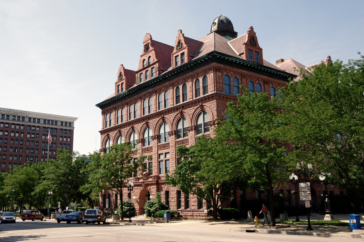


Peoria, Illinois
Peoria is a city of 112,169 people in Peoria County, Illinois, founded in 1680.
Why visit Peoria
Townapedia lists 49 museums and landmarks, 80 parks and trails, 186 places to eat, 20 places to stay and 15 attractions in and around town.
Highlights include Grandview Drive, Madison Theatre, John C. Flanagan House Museum and Pettingill-Morron House.
July is the warmest month, with average highs of 86°F; January lows average 18°F, and about 26 inches of snow fall in a normal year.
Weather in Peoria
Forecast from the National Weather Service. Full forecast
About Peoria
Peoria is a city in Peoria County, Illinois, United States, and its county seat. Located on the Illinois River, the city had a population of 113,150 as of the 2020 census, making it the eighth-most populous city in Illinois. It is the principal city of the Peoria metropolitan area in Central Illinois, consisting of Fulton, Marshall, Peoria, Stark, Tazewell, and Woodford counties and had a combined population of 402,391 in 2020.
From the Wikipedia article Peoria, Illinois (this version), under CC BY-SA 4.0.
Things to do15

Grandview Drive
Monument and historic site · National Register of Historic Places · 3.4 mi
Bluff road in Peoria County, Illinois

Madison Theatre
Cinema and theater · National Register of Historic Places · 4.2 mi
Theater and former movie theater in Peoria, Illinois, United States

Bob Michel Bridge
Bridge · 4.8 mi
IL 40 over the Illinois River between Peoria & E. Peoria, Illinois
Cedar Street Bridge
Bridge · 5.2 mi
Bridge over Illinois River between Peoria & E. Peoria, Illinois
McClugage Bridge
Bridge · 4.3 mi
Twin bridge over the Illinois River in Illinois, USA
Murray Baker Bridge
Bridge · 4.8 mi
I-74 over Illinois River between Peoria & E. Peoria, Illinois

Wildlife Prairie Park
Zoo and aquarium · 6.9 mi
Animal and nature park in Illinois, USA
3 more on the map.
Museums and landmarks49

John C. Flanagan House Museum
Museum · National Register of Historic Places · 3.7 mi
Historic house in Illinois, United States
942 Northeast Glen Oak Avenue, Peoria

Pettingill-Morron House
Museum · National Register of Historic Places · 4.0 mi
Historic house in Illinois, United States
1212 West Moss Avenue, Peoria
Th 10:00-14:00
Illinois Waterway Project Office
Monument and historic site · National Register of Historic Places · 4.2 mi
U.S. Army Core of Engineers facility in Peoria, Illinois
257 Grant Street, Peoria
Peoria City Hall
Monument and historic site · National Register of Historic Places · 4.3 mi
City headquarters in downtown Peoria, Illinois, USA
419 Fulton Street, Peoria
Central National Bank Building
Monument and historic site · National Register of Historic Places · 4.4 mi
Building in downtown Peoria, Illinois
Downtown Peoria Historic District
Monument and historic site · National Register of Historic Places · 4.3 mi
Historic district in Illinois, United States
Grand Army of the Republic Memorial Hall
Monument and historic site · National Register of Historic Places · 4.2 mi
Historic meeting hall in downtown Peoria, Illinois, USA
Hotel Père Marquette
Monument and historic site · National Register of Historic Places · 4.2 mi
Hotel in downtown Peoria, Illinois
International Harvester Building
Monument and historic site · National Register of Historic Places · 4.9 mi
Historic building in Peoria, Illinois, United States

John C. Proctor Recreation Center
Museum · National Register of Historic Places · 4.6 mi
1913 building in Peoria, Illinois
Judge Jacob Gale House
Monument and historic site · National Register of Historic Places · 4.2 mi
Historic house in Illinois, United States
Kickapoo Building
Monument and historic site · National Register of Historic Places · 4.0 mi
Historic building in Peoria, Illinois, USA
37 more on the map.
Parks, trails and playgrounds80


Laura Bradley Park
Park · 3.2 mi
Public park in Peoria, Illinois, United States
1317 North Park Road, Peoria
sunrise-sunset

Forest Park
Hiking and trails · 1.8 mi
540-acre nature center and preserve
5809 North Forest Park Drive, Peoria Heights
dawn-dusk

Bielfeldt Park
Park · 2.9 mi
5319 North Galena Road, Peoria Heights
sunrise-sunset
Peoria Zoo
Park · 3.4 mi
Public zoo in Glen Oak Park, Peoria, Illinois


68 more on the map.
Restaurants and cafes186

Asia Grill
Restaurant · Chinese · 1.4 mi
5832 North Knoxville Avenue, Peoria
Tu-Th 10:30-21:30; Fr-Sa 10:30-22:00; Su 11:00-21:00
Brienzo's Pizza + Bar
Restaurant · Pizza · 3.9 mi
7713 North Orange Prairie Road, Peoria
Su-Th 11:00-21:00; Fr-Sa 11:00-22:00
Casa Agave
Restaurant · Mexican · 2.3 mi
4542 North Prospect Road
Mo-Th 11:00-21:30; Fr 11:00-22:00; Sa 09:30-22:00

Childers Eatery Junction City
Diner · American · 1.4 mi
5805 North Humboldt Avenue, Peoria
Mo-Su 07:00-15:00

CxT Roasting Company
Cafe · Coffee Shop · 1.3 mi
6035 North Knoxville Avenue, Peoria
Mo-Fr 06:30-19:00, Sa 07:00-19:00, Su 08:00-17:00
Hacienda el Mirador
Restaurant · Mexican · 1.4 mi
5805 North Humboldt Avenue, Peoria
Mo-Th 11:00-22:00; Fr, Sa 10:00-23:00; Su 10:00-22:00
IHOP
Restaurant · Breakfast, Pancake · 0.9 mi
5012 North Big Hollow Road, Peoria
Mo-We 07:00-22:00; Th 07:00-24:00; Fr,Sa 00:00-24:00; Su 00:00-22:00
Indian Tadka
Restaurant · Indian · 2.2 mi
7815 Knoxville Avenue
Tu-Sa 11:00-14:30, 17:00-21:30; Su 11:00-14:30, 17:00-20:30
Intuition Coffee
Cafe · Coffee Shop · 4.0 mi
734 Main Street, Peoria
Mo-Fr 06:00-15:00; Sa-Su 07:00-15:00

Kenny's Westside Pub
Bar and pub · Irish · 4.3 mi
112 Southwest Jefferson Avenue, Peoria
Su-Sa 11:00-04:00
174 more on the map.
History
Peoria was the earliest permanent European settlement in what is now Illinois; French explorers first established a presence along the Illinois River in the late 17th century, with the community later evolving into the modern city. The lands that eventually would become Peoria were first settled by Europeans in 1680, when French explorers René-Robert Cavelier, Sieur de La Salle and Henri de Tonti constructed Fort Crevecoeur. This fort burned to the ground, and in 1813, Fort Clark, Illinois was built. When the County of Peoria was organized in 1825, Fort Clark was officially named Peoria.
From the History section of Peoria, Illinois on Wikipedia, under CC BY-SA 4.0.
Where to stay20
Churches and places of worship115
Cathedral of Saint Mary of The Immaculate Conception
Church · Roman Catholic · 4.0 mi
607 Northeast Madison Avenue, Peoria
Christ Church of Lower Kickapoo
Church · National Register of Historic Places · 6.1 mi
Cumberland Presbyterian Church
Church · National Register of Historic Places · 4.2 mi
Grace and Peace Lutheran Church
Church · Evangelical Lutheran · 2.1 mi
7611 North Knoxville Avenue, Peoria
Shopping37
Forest Park Nature Center
Shop · 2.2 mi
5809 North Forest Park Drive, Peoria Heights
Gas and EV charging27
Schools, colleges and libraries92
Healthcare31
OSF HealthCare Cardiovascular Institute
Clinic and pharmacy · 1.2 mi
5405 North Knoxville Avenue, Peoria
OSF HealthCare Transitional Care Hospital
Hospital · 4.1 mi
500 West Romeo B. Garrett Avenue, Peoria
Map of Peoria
250 places. The map loads OpenStreetMap tiles when you open it.
Climate by month
Monthly table
| Month | High | Low | Rain | Snow |
|---|---|---|---|---|
| Jan | 34°F | 18°F | 2.1 in | 7.7 in |
| Feb | 39°F | 21°F | 2.0 in | 6.9 in |
| Mar | 51°F | 32°F | 2.7 in | 3.3 in |
| Apr | 64°F | 42°F | 4.0 in | 0.5 in |
| May | 74°F | 53°F | 4.7 in | 0.0 in |
| Jun | 83°F | 62°F | 3.7 in | 0.0 in |
| Jul | 86°F | 66°F | 3.5 in | 0.0 in |
| Aug | 85°F | 64°F | 3.3 in | 0.0 in |
| Sep | 78°F | 56°F | 3.5 in | 0.0 in |
| Oct | 65°F | 44°F | 3.2 in | 0.1 in |
| Nov | 51°F | 33°F | 2.7 in | 1.5 in |
| Dec | 38°F | 23°F | 2.2 in | 6.2 in |
U.S. Climate Normals 1991-2020 for Peoria Gtr Peoria Ap Gsn 72532 (7 mi away), NOAA NCEI.
People and cost of living
American Community Survey 5-year estimates, 2020-2024, U.S. Census Bureau. Estimates have margins of error, larger for small towns.
Disaster history
Peoria County has had 8 federal disaster declarations since 2000, most often for snowstorms.
- 2020-03-26: Covid-19 Pandemic (Biological)
- 2020-03-13: Covid-19 (Biological)
- 2013-05-10: Severe Storms, Straight-Line Winds, And Flooding (Flood)
- 2011-03-17: Severe Winter Storm And Snowstorm (Snowstorm)
- 2008-10-03: Severe Storms And Flooding (Severe Storm)
- 2006-12-29: Snow (Snowstorm)
OpenFEMA disaster declarations summaries.
Getting there and nearby towns
Peoria International Airport (PIA) is the nearest airport with scheduled flights listed in OpenStreetMap, 7 miles away.
- Peoria Heights 2 mi east, about 4 min by car
- West Peoria 4 mi south, about 6 min by car
- Bellevue 5 mi southwest, about 9 min by car
- East Peoria 7 mi southeast, about 11 min by car
- Dunlap 7 mi northwest, about 12 min by car
- Creve Coeur 8 mi south, about 12 min by car
- Bartonville 8 mi south, about 13 min by car
- Germantown Hills 8 mi east, about 13 min by car
- Marquette Heights 9 mi south, about 15 min by car
- Washington 10 mi east, about 16 min by car
Drive times are estimates from straight-line distance, not routes.
Local news
Headlines from INDB, the NEMICO news database.
Reviews, tips and questions
Loading what members have shared...
Sources and licences
- NCES EDGE (Public domain): public schools
- NOAA NCEI U.S. Climate Normals 1991-2020 (Public domain): climate by month
- OpenFEMA (Public domain): disaster declarations
- OpenStreetMap contributors (ODbL 1.0): places, airports, map data
- U.S. Census Bureau (Public domain): population, income, housing, education, commute
- Wikidata (CC0 1.0): elevation, founding date, time zone, website, landmarks and historic places
- Wikimedia Commons (see each image): photos
- Wikipedia (CC BY-SA 4.0): overview and history text
Photo credits
- Peoria City Hall, Unknown author, CC BY-SA 2.5
- Race and ethnicity 2020 Peoria, IL, CensusDots, CC BY-SA 4.0
- Peoria - St. Vincent de Paul 1977, Roger Wollstadt, CC BY-SA 2.0
- Peoria - Ben Schwartz Food Mart 1976, Roger W, CC BY-SA 2.0
- Courtyard by Marriott - Peoria, Farragutful, CC BY-SA 4.0
- Residence Inn by Marriott - Peoria, Farragutful, CC BY-SA 4.0
- Saint Paul's Episcopal Church tower - Peoria, Farragutful, CC BY-SA 4.0
- Saint Paul's Episcopal Church - Peoria 01, Farragutful, CC BY-SA 4.0
- Saint Paul's Episcopal Church - Peoria 02, Farragutful, CC BY-SA 4.0
- Upper Peoria Lake Peoria Heights tower 20231021 0757, NatFee, CC BY-SA 4.0
- Playground at Becker Park Peoria IL, Shy gear, CC BY-SA 4.0
- Picnic Shelter at Becker Park Peoria IL - 1, Shy gear, CC BY-SA 4.0
- Skate park at Becker Park Peoria IL, Shy gear, CC BY-SA 4.0
- Picnic shelter at Becker Park Peoria IL - 2, Shy gear, CC BY-SA 4.0
- Picnic shelter at Becker Park Peoria IL - 3, Shy gear, CC BY-SA 4.0
- Basketball hoops at Becker Park Peoria IL, Shy gear, CC BY-SA 4.0
- Peoria - Northwest from Savings Tower, Roger Wollstadt from Sarasota, Florida, CC BY-SA 2.0
- TAYLOR-Jonathan-Boyce-Grave Peoria 20240328 0663, NatFee, CC BY-SA 4.0
- Wallaby at Peoria Zoo (50308075701), Joseph Gage from Yorkville, IL, USA, CC BY-SA 2.0
- Cygnus atratus at the Peoria Zoo, Joseph Gage, CC BY-SA 2.0
- Green Door Adult Superstore Peoria IL, Shy gear, CC BY-SA 4.0
- Peoria County, Illinois - DSCF2393-300, Joe K Gage, CC BY-SA 2.0
- Peoria County, Illinois - DSCF2400-303, Joe K Gage, CC BY-SA 2.0
- Peoria County, Illinois - DSCF2395-301, Joe K Gage, CC BY-SA 2.0
- Peoria 20240416 0331, NatFee, CC BY-SA 4.0
- St. Joseph Cemetery - West Peoria, Farragutful, CC BY-SA 4.0
- Emmaus House - West Peoria, Farragutful, CC BY-SA 4.0
- Immaculate Conception Convent - West Peoria 04, Farragutful, CC BY-SA 4.0
- Laura Bradley Park Japanese Bridge Peoria 20240329 0708, NatFee, CC BY-SA 4.0
- John C. Flanagan House, Wonderrenae, CC BY-SA 3.0
- Pettingill-Morron House, Mmikhailova, CC BY-SA 3.0
- Cathedral of St. Mary Peoria Illinois, Farragutful, Public domain
- Bradley Hall, Bradley University, AscendedAnathema, CC BY-SA 3.0
- Varney Field at Kellar, Christopher Glenn, CC BY-SA 3.0
- Detwiler Pool front elevation Point Place, Ohio, Astra Vero, CC BY-SA 4.0
- ISS038-E-63459 - View of Earth, Earth Science and Remote Sensing Unit , Lyndon B. Johnson Space Center, Public domain
- ISS038-E-63457 - View of Earth, Earth Science and Remote Sensing Unit , Lyndon B. Johnson Space Center, Public domain
- ISS038-E-63458 - View of Earth, Earth Science and Remote Sensing Unit , Lyndon B. Johnson Space Center, Public domain
- ISS029-E-38648 - View of Earth, Earth Science and Remote Sensing Unit , Lyndon B. Johnson Space Center, Public domain


Page built October 30, 2026. Spotted a mistake? Tell us or suggest a place.