




Cudahy, California
Cudahy is a city of 22,087 people in Los Angeles County, California, founded in 1960.
Why visit Cudahy
Townapedia lists 4 museums and landmarks, 20 parks and trails, 80 places to eat, 8 places to stay and 1 attraction in and around town.
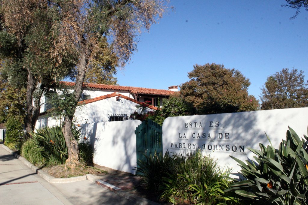
Highlights include Regal Edwards South Gate & IMAX, Casa de Parley Johnson, Lynwood Pacific Electric Railway Depot and Lugo Park.
August is the warmest month, with average highs of 84°F; December lows average 48°F.
Weather in Cudahy
Forecast from the National Weather Service. Full forecast
About Cudahy
Cudahy is a city located in southeastern Los Angeles County, California, United States. Cudahy has one of the highest population densities of any incorporated city in the United States. It is part of the Gateway Cities region and had a population of 22,811 as of the 2020 U.S. census.
From the Wikipedia article Cudahy, California (this version), under CC BY-SA 4.0.
Things to do1

Museums and landmarks4
Casa de Parley Johnson
Monument and historic site · National Register of Historic Places · 2.9 mi
Historic house in Downey, California
Lynwood Pacific Electric Railway Depot
Monument and historic site · National Register of Historic Places · 3.1 mi
Railway station of the Pacific Electric Railway, located in Lynwood, California

South Gate Museum & Art Gallery
Museum · 1.5 mi
8680 California Avenue, South Gate
Parks, trails and playgrounds20


South Gate Golf Course
Golf course · 1.4 mi
9-Hole Par 3 course. Also offers disc golf.
9615 Pinehurst Avenue, South Gate
Mo-Su 08:00-16:00
8 more on the map.
Restaurants and cafes80

Tierra Mia Coffee
Cafe · Coffee Shop · 0.9 mi
4914 Firestone Boulevard, South Gate
Su-Th 06:00-24:00; Fr-Sa 06:00-25:00

Super Pizza Veloz
Restaurant · Pizza · 1.0 mi
Pizza Restaurant in Bell Gardens, CA
7625 Eastern Ave, #A, Bell Gardens
Mo-Th 10:00-21:00, Fr-Sa 10:00-22:00, Su 12:00-21:00
Tacos El Gavilan
Restaurant · Mexican · 0.6 mi
4406 Florence Avenue, Bell
Su-Th 10:00-24:00; Fr-Sa 10:00-26:00
World Famous Grill
Restaurant · Arab, Mexican · 0.8 mi
4143 E. Florence Avenue
Su-Tu, Th 10:00-21:00; We 10:00-20:30; Fr-Sa 10:00-22:00
LA Diosa de los Moles
Restaurant · Mexican · 1.5 mi
7883 Garfield Avenue
Mo-Su 09:00-21:00

68 more on the map.
History
Cudahy is named for its founder, meat-packing baron Michael Cudahy, who purchased the original 2,777 acres (1,124 hectares) of Rancho San Antonio in 1908 to resell as 1-acre (44,000 ft2; 4,000 m2; 0.40 ha) lots. These "Cudahy lots" were notable for their size—in most cases, 50 to 100 feet (15 to 30 m) in width and 600 to 800 feet (183 to 244 m) in depth, at least equivalent to a city block in most American towns. Such parcels, often referred to as "railroad lots", were intended to allow the new town's residents to keep a large vegetable garden, a grove of fruit trees (usually citrus), and a chicken coop or horse stable. This arrangement, popular in the towns along the lower Los Angeles and San Gabriel rivers, proved particularly attractive to the Southerners and Midwesterners who were leaving their struggling farms in droves in the 1910s and 1920s to start new lives in Southern California.
As late as the 1950s, some Cudahy residents were still riding into the city's downtown areas on horseback. After World War II the city was a White American blue collar town with steel and automobile plants in the area.
From the History section of Cudahy, California on Wikipedia, under CC BY-SA 4.0.
Where to stay8
Rodeway Inn South Gate - Los Angeles South
Motel and hotel · 0.9 mi
8911 S. Atlantic Avenue, South Gate
Quality Inn & Suites Bell Gardens-Los Angeles
Motel and hotel · 1.1 mi
7330 Eastern Avenue, Bell Gardens
Travelodge Inn & Suites Bell Los Angeles Area
Motel and hotel · 0.9 mi
6600 Atlantic Avenue, Bell
Churches and places of worship40
Sagrado Corazon y Santa Maria Guadalupe Catholic Church
Church · Roman Catholic · 0.6 mi
4235 Clara Street, Cudahy
Ministerios Una Voz Profetica
Church · Evangelical · 0.5 mi
8333 Atlantic Avenue, Cudahy
Shopping17
Gas and EV charging7
Schools, colleges and libraries63
Healthcare5
Map of Cudahy
245 places. The map loads OpenStreetMap tiles when you open it.
Climate by month
Monthly table
| Month | High | Low | Rain |
|---|---|---|---|
| Jan | 68°F | 49°F | 3.3 in |
| Feb | 68°F | 50°F | 3.6 in |
| Mar | 70°F | 52°F | 2.2 in |
| Apr | 72°F | 55°F | 0.7 in |
| May | 74°F | 58°F | 0.3 in |
| Jun | 77°F | 61°F | 0.1 in |
| Jul | 82°F | 65°F | 0.0 in |
| Aug | 84°F | 65°F | 0.0 in |
| Sep | 83°F | 64°F | 0.1 in |
| Oct | 79°F | 60°F | 0.6 in |
| Nov | 73°F | 53°F | 0.8 in |
| Dec | 67°F | 48°F | 2.5 in |
U.S. Climate Normals 1991-2020 for Los Angeles Dwtn Usc Campus (7 mi away), NOAA NCEI.
People and cost of living
American Community Survey 5-year estimates, 2020-2024, U.S. Census Bureau. Estimates have margins of error, larger for small towns.
Disaster history
Los Angeles County has had 67 federal disaster declarations since 2000, most often for fires.
- 2025-08-08: Canyon Fire (Fire)
- 2025-01-08: Wildfires And Straight-Line Winds (Fire)
- 2025-01-08: Eaton Fire (Fire)
- 2025-01-08: Hurst Fire (Fire)
- 2025-01-07: Palisades Fire (Fire)
- 2024-12-10: Franklin Fire (Fire)
OpenFEMA disaster declarations summaries.
Getting there and nearby towns
Compton / Woodley Airport (CPM) is the nearest airport with scheduled flights listed in OpenStreetMap, 6 miles away.
- Bell 1 mi north, about 2 min by car
- South Gate 1 mi southwest, about 2 min by car
- Bell Gardens 2 mi east, about 3 min by car
- Maywood 2 mi north, about 3 min by car
- Huntington Park 2 mi northwest, about 4 min by car
- Walnut Park 2 mi west, about 4 min by car
- Lynwood 3 mi south, about 5 min by car
- Commerce 3 mi northeast, about 5 min by car
- Downey 3 mi southeast, about 6 min by car
- Florence-Graham 4 mi west, about 6 min by car
Drive times are estimates from straight-line distance, not routes.
Local news
Headlines from INDB, the NEMICO news database.
Reviews, tips and questions
Loading what members have shared...
Sources and licences
- NCES EDGE (Public domain): public schools
- NOAA NCEI U.S. Climate Normals 1991-2020 (Public domain): climate by month
- OpenFEMA (Public domain): disaster declarations
- OpenStreetMap contributors (ODbL 1.0): places, airports, map data
- U.S. Census Bureau (Public domain): population, income, housing, education, commute
- Wikidata (CC0 1.0): elevation, founding date, time zone, website, landmarks and historic places
- Wikimedia Commons (see each image): photos
- Wikipedia (CC BY-SA 4.0): overview and history text
Photo credits
- TAL Container in Cudahy, Eric Polk, CC BY-SA 4.0
- Lynwood Pacific Electric Railway Depot (Lynwood, CA), John F. Meyerpeter, HABS photographer, Public domain
- ParleyJohnson, Floatjon, CC BY-SA 3.0
- 2021-10-05 14 20 34 View southwest along the Los Angeles River and Interstate 710 towards the Port of Long Beach in southern Los Angeles County, California from an airplane heading toward Los Angeles..., Famartin, CC BY-SA 4.0
- Coca-Cola semi-trailer, Epolk, CC BY-SA 4.0
- Ocean Network Express container on the road, Eric Polk, CC BY-SA 4.0
- Evergreen Marine Corp shipping container, Epolk, CC BY-SA 4.0
- Claudia D. Hernández, Claudia D. Hernández, CC BY-SA 4.0
- 2021-10-05 14 20 22 View southwest along the Los Angeles River and Interstate 710 towards the Port of Long Beach in southern Los Angeles County, California from an airplane heading toward Los Angeles..., Famartin, CC BY-SA 4.0
- NCFT 013024, Banuai75, CC BY-SA 4.0
- Centromadia parryi ssp. australis, redrovertracy, CC BY 4.0
- City of South Gate Centennial, SouthGateCommunity, CC BY-SA 4.0
- 2021-10-05 14 20 16 View southwest along the Los Angeles River and Interstate 710 towards the Port of Long Beach in southern Los Angeles County, California from an airplane heading toward Los Angeles..., Famartin, CC BY-SA 4.0


Page built October 30, 2026. Spotted a mistake? Tell us or suggest a place.