


Commerce, California
Commerce is a city of 11,993 people in Los Angeles County, California, founded in 1960.
Why visit Commerce
Townapedia lists 14 museums and landmarks, 25 parks and trails, 87 places to eat, 10 places to stay and 2 attractions in and around town.
Highlights include Regency Commerce 14, Casa de Parley Johnson, Golden Gate Theater and Darwell Park.
August is the warmest month, with average highs of 84°F; December lows average 48°F.
Weather in Commerce
Forecast from the National Weather Service. Full forecast
About Commerce
Commerce is a city located in southeast Los Angeles County, California, United States. The population was 12,378 at the 2020 census, down from 12,823 at the 2010 census. It is usually referred to as the City of Commerce to distinguish it from the common noun. It is bordered by Vernon on the west, Los Angeles on the northwest, East Los Angeles on the north, Montebello on the east, Downey and Bell Gardens on the south, and Maywood on the southwest.
From the Wikipedia article Commerce, California (this version), under CC BY-SA 4.0.
Things to do2

Museums and landmarks14
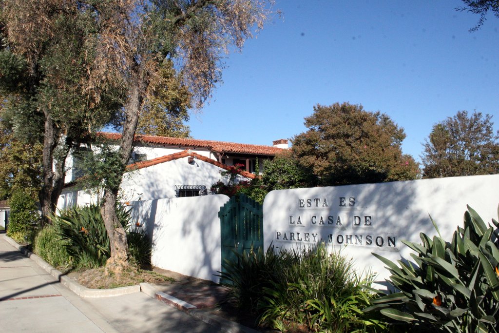
Casa de Parley Johnson
Monument and historic site · National Register of Historic Places · 2.8 mi
Historic house in Downey, California

Golden Gate Theater
Monument and historic site · National Register of Historic Places · 1.8 mi
Former movie theater in East Los Angeles, California, United States, now a drugstore

Oldest McDonald's restaurant
Museum · National Register of Historic Places · 3.8 mi
United States historic places

Robert Louis Stevenson Branch
Monument and historic site · National Register of Historic Places · 3.6 mi
Public library in Los Angeles, California, USA

Armenian Genocide Martyrs Monument
Monument and historic site · 2.6 mi
Monument in Montebello, California, USA
Cinco Puntos Memorial
Monument and historic site · 4.0 mi
Monument in Los Angeles, California


Vincent Price Art Museum
Museum · 3.1 mi
Art museum located at East Los Angeles College in Monterey Park, CA, USA
Hispanic American Veterans Memorial
Monument and historic site · 1.8 mi
Memorial to Hispanic American Congressional Medal of Honor Recipients
2 more on the map.
Parks, trails and playgrounds25

Treasure Island Park
Park · 2.1 mi
Dog Park, rest stop, water stop, water conservation park and picnic area
9300 South Bluff Rd, Downey
Veterans Memorial Park
Park · 2.0 mi
6364 Zindell Avenue, Commerce
Hannon Park
Park · 1.8 mi
Hannon Park, Jungle Gym, Basketball court, Picnic area, Swings, grass area
6513 Scout, Bell Gardens
Mo-Su 06:00-21:00
13 more on the map.
Restaurants and cafes87

Super Pizza Veloz
Restaurant · Pizza · 2.3 mi
Pizza Restaurant in Bell Gardens, CA
7625 Eastern Ave, #A, Bell Gardens
Mo-Th 10:00-21:00, Fr-Sa 10:00-22:00, Su 12:00-21:00

The Coffee Bean & Tea Leaf
Cafe · Coffee Shop · 0.4 mi
6320 East Washington Boulevard, Commerce
Mo-Fr 06:00-21:00; Sa-Su 07:00-21:00


LA Diosa de los Moles
Restaurant · Mexican · 2.4 mi
7883 Garfield Avenue
Mo-Su 09:00-21:00
Mui Sushi
Restaurant · Japanese · 2.1 mi
6370 Florence Avenue
Tu-Th 11:30-20:15; Fr 11:30-20:45; Sa-Su 13:00-20:15

75 more on the map.
History
In the 19th century, the area was part of Antonio Maria Lugo's Rancho San Antonio. Its conversion to an industrial area began in 1887, when the Atchison, Topeka and Santa Fe Railway built its main line through the area. The ranch remained intact until Arcadia Bandini de Stearns Baker, reputedly once the wealthiest woman in Los Angeles, sold some of it around the turn of the 20th century. The Atchison, Topeka and Santa Fe Railway and Los Angeles and Salt Lake Railroad (later the Union Pacific) both were built through what would become the community, as was the Pacific Electric Railway's Whittier Line. By the 1920s, factories had arrived. In the late 1940s, industrial leaders banded together with residents in the communities of Bandini, Rosewood, and Laguna to encourage commerce. They changed the name to match that goal.
From the History section of Commerce, California on Wikipedia, under CC BY-SA 4.0.
Where to stay10
Quality Inn & Suites Bell Gardens-Los Angeles
Motel and hotel · 2.1 mi
7330 Eastern Avenue, Bell Gardens
Quality Inn & Suites Montebello - Los Angeles
Motel and hotel · 1.9 mi
7709 Telegraph Road, Montebello
Travelodge Inn & Suites Bell Los Angeles Area
Motel and hotel · 2.5 mi
6600 Atlantic Avenue, Bell
Churches and places of worship65
Kingdom Hall of Jehovahs Witnesses
Church · Jehovahs Witness · 1.7 mi
6525 Priam Drive
Park Avenue Christian Church
Church · Independent Christian · 2.3 mi
113 South Park Avenue, Montebello
Shopping12
Gas and EV charging21
Commerce Truck Stop
Gas station · 1.7 mi
4560 East Washington Boulevard, Commerce
Schools, colleges and libraries85
Healthcare3
Map of Commerce
250 places. The map loads OpenStreetMap tiles when you open it.
Climate by month
Monthly table
| Month | High | Low | Rain |
|---|---|---|---|
| Jan | 68°F | 49°F | 3.3 in |
| Feb | 68°F | 50°F | 3.6 in |
| Mar | 70°F | 52°F | 2.2 in |
| Apr | 72°F | 55°F | 0.7 in |
| May | 74°F | 58°F | 0.3 in |
| Jun | 77°F | 61°F | 0.1 in |
| Jul | 82°F | 65°F | 0.0 in |
| Aug | 84°F | 65°F | 0.0 in |
| Sep | 83°F | 64°F | 0.1 in |
| Oct | 79°F | 60°F | 0.6 in |
| Nov | 73°F | 53°F | 0.8 in |
| Dec | 67°F | 48°F | 2.5 in |
U.S. Climate Normals 1991-2020 for Los Angeles Dwtn Usc Campus (6 mi away), NOAA NCEI.
People and cost of living
American Community Survey 5-year estimates, 2020-2024, U.S. Census Bureau. Estimates have margins of error, larger for small towns.
Disaster history
Los Angeles County has had 67 federal disaster declarations since 2000, most often for fires.
- 2025-08-08: Canyon Fire (Fire)
- 2025-01-08: Wildfires And Straight-Line Winds (Fire)
- 2025-01-08: Eaton Fire (Fire)
- 2025-01-08: Hurst Fire (Fire)
- 2025-01-07: Palisades Fire (Fire)
- 2024-12-10: Franklin Fire (Fire)
OpenFEMA disaster declarations summaries.
Getting there and nearby towns
San Gabriel Valley Airport (EMT) is the nearest airport with scheduled flights listed in OpenStreetMap, 9 miles away.
- Bell 2 mi southwest, about 3 min by car
- Bell Gardens 2 mi south, about 3 min by car
- Maywood 2 mi west, about 4 min by car
- Montebello 3 mi northeast, about 4 min by car
- East Los Angeles 3 mi northwest, about 4 min by car
- Cudahy 3 mi southwest, about 5 min by car
- Pico Rivera 4 mi east, about 6 min by car
- Monterey Park 4 mi north, about 6 min by car
- Downey 4 mi south, about 7 min by car
- Huntington Park 4 mi west, about 6 min by car
Drive times are estimates from straight-line distance, not routes.
Local news
Headlines from INDB, the NEMICO news database.
Reviews, tips and questions
Loading what members have shared...
Sources and licences
- NCES EDGE (Public domain): public schools
- NOAA NCEI U.S. Climate Normals 1991-2020 (Public domain): climate by month
- OpenFEMA (Public domain): disaster declarations
- OpenStreetMap contributors (ODbL 1.0): places, airports, map data
- U.S. Census Bureau (Public domain): population, income, housing, education, commute
- Wikidata (CC0 1.0): elevation, founding date, time zone, website, landmarks and historic places
- Wikimedia Commons (see each image): photos
- Wikipedia (CC BY-SA 4.0): overview and history text
Photo credits
- CommerceMontageCA, Justefrain, CC BY-SA 3.0
- View of Los Angeles Skyline from Commerce, California (14517769445), Ken Lund from Reno, Nevada, USA, CC BY-SA 2.0
- Citadel Outlet Mall, City of Commerce, California (14516684582), Ken Lund from Reno, Nevada, USA, CC BY-SA 2.0
- Commerce Casino from Across Interstate 5, Commerce, California (14331115220), Ken Lund from Reno, Nevada, USA, CC BY-SA 2.0
- Commerce, CA, USA - panoramio (21), peter boy12qq12, CC BY 3.0
- Commerce, CA, USA - panoramio (13), peter boy12qq12, CC BY 3.0
- Commerce, CA, USA - panoramio (12), peter boy12qq12, CC BY 3.0
- Commerce, CA, USA - panoramio (17), peter boy12qq12, CC BY 3.0
- Commerce, CA, USA - panoramio (24), peter boy12qq12, CC BY 3.0
- Commerce, CA, USA - panoramio (11), peter boy12qq12, CC BY 3.0
- Commerce, CA, USA - panoramio (15), peter boy12qq12, CC BY 3.0
- Commerce, CA, USA - panoramio (10), peter boy12qq12, CC BY 3.0
- Commerce, CA, USA - panoramio (23), peter boy12qq12, CC BY 3.0
- Commerce, CA, USA - panoramio (6), peter boy12qq12, CC BY 3.0
- Commerce, CA, USA - panoramio (9), peter boy12qq12, CC BY 3.0
- Commerce, CA, USA - panoramio (14), peter boy12qq12, CC BY 3.0
- Commerce, CA, USA - panoramio (18), peter boy12qq12, CC BY 3.0
- Commerce, CA, USA - panoramio (26), peter boy12qq12, CC BY 3.0
- Commerce, CA, USA - panoramio (22), peter boy12qq12, CC BY 3.0
- Commerce, CA, USA - panoramio (25), peter boy12qq12, CC BY 3.0
- Commerce, CA, USA - panoramio (20), peter boy12qq12, CC BY 3.0
- Commerce, CA, USA - panoramio (7), peter boy12qq12, CC BY 3.0
- Commerce, CA, USA - panoramio (29), peter boy12qq12, CC BY 3.0
- Commerce, CA, USA - panoramio (1), peter boy12qq12, CC BY 3.0
- Commerce, CA, USA - panoramio (5), peter boy12qq12, CC BY 3.0
- Commerce, CA, USA - panoramio (8), peter boy12qq12, CC BY 3.0
- Commerce, CA, USA - panoramio (28), peter boy12qq12, CC BY 3.0
- Commerce, CA, USA - panoramio (19), peter boy12qq12, CC BY 3.0
- Commerce, CA, USA - panoramio, peter boy12qq12, CC BY 3.0
- Commerce, CA, USA - panoramio (16), peter boy12qq12, CC BY 3.0
- Commerce, CA, USA - panoramio (27), peter boy12qq12, CC BY 3.0
- Commerce, CA, USA - panoramio (4), peter boy12qq12, CC BY 3.0
- Commerce, CA, USA - panoramio (2), peter boy12qq12, CC BY 3.0
- Commerce, CA, USA - panoramio (3), peter boy12qq12, CC BY 3.0
- Old Theater, 5190 Whittier Blvd., Los Angeles, Los Angeles, CC BY-SA 4.0
- ParleyJohnson, Floatjon, CC BY-SA 3.0
- Robert Louis Stevenson Branch Library, Los Angeles, Los Angeles, CC BY-SA 3.0
- Vincent Price Art Museum, California, BriefEdits, CC BY-SA 4.0
- Frank Wiese, PokerProLV1973, CC0
- Stacey Long performing in Los Angeles, Yauwing2, CC0


Page built October 30, 2026. Spotted a mistake? Tell us or suggest a place.