


Cuyahoga Falls, Ohio
Cuyahoga Falls is a city of 50,909 people in Summit County, Ohio, founded in 1812.
Why visit Cuyahoga Falls
Townapedia lists 29 museums and landmarks, 56 parks and trails, 110 places to eat, 10 places to stay and 10 attractions in and around town.
Highlights include Everett Covered Bridge, Cinemark - Cuyahoga Falls, Peninsula Village Historic District and Boston Mills Historic District.
July is the warmest month, with average highs of 82°F; January lows average 18°F.
Weather in Cuyahoga Falls
Forecast from the National Weather Service. Full forecast
About Cuyahoga Falls
Cuyahoga Falls is a city in Summit County, Ohio, United States. The population was 51,114 at the 2020 census. The second-largest city in Summit County, it is located directly north of Akron and is a suburb in the Akron metropolitan area. The city was founded in 1812 by William Wetmore and was originally named Manchester, but renamed for the Cuyahoga River and the series of waterfalls that run along the southern boundary of the city.
From the Wikipedia article Cuyahoga Falls, Ohio (this version), under CC BY-SA 4.0.
Things to do10




Museums and landmarks29

Peninsula Village Historic District
Monument and historic site · National Register of Historic Places · 4.1 mi
Historic district in Ohio, United States

Boston Mills Historic District
Monument and historic site · National Register of Historic Places · 5.6 mi
In Ohio, United States

Botzum Farm
Monument and historic site · National Register of Historic Places · 1.5 mi
Farm in Summit County, United States of America

Dr. Robert Smith House
Monument and historic site · National Register of Historic Places · 6.0 mi
Historic house museum at 855 Ardmore Avenue in Akron, Ohio

Everett Historic District
Monument and historic site · National Register of Historic Places · 1.9 mi
Listed on the NRHP in Ohio
Everett Knoll Complex
Monument and historic site · National Register of Historic Places · 1.9 mi
Archaeological site in Ohio, United States


Hale Farm and Village
Monument and historic site · National Register of Historic Places · 2.2 mi
Building in Ohio, United States
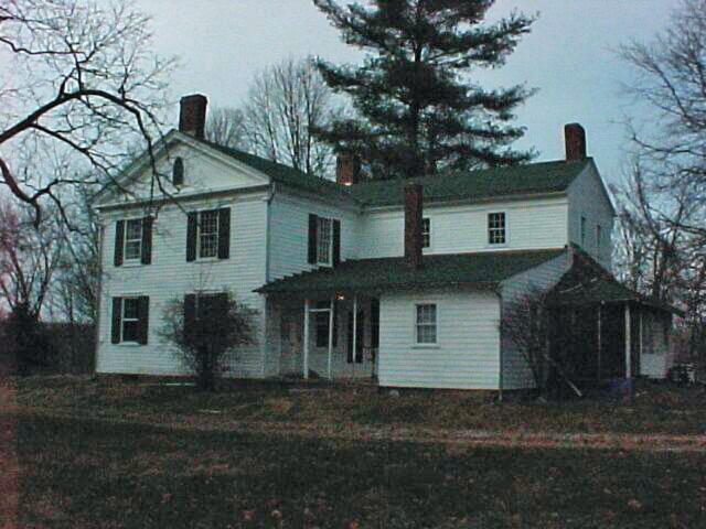
Jim Brown House
Monument and historic site · National Register of Historic Places · 1.3 mi
Peninsula, Ohio, listed on the NRHP in Summit County, Ohio

Oakwood Cemetery Chapel
Monument and historic site · National Register of Historic Places · 4.4 mi
Historic chapel in Cuyahoga Falls, Summit County, Ohio


Stan Hywet Hall and Gardens
Monument and historic site · National Register of Historic Places · 4.4 mi
Non-profit organization in the USA
Valley Railway Historic District
Monument and historic site · National Register of Historic Places · 3.2 mi
Historic district in Ohio, United States
17 more on the map.
Parks, trails and playgrounds56

Cuyahoga Valley National Park
Park · 4.1 mi
National park in Ohio, United States

Deep Lock Quarry Metro Park
Hiking and trails · 3.6 mi
5779 Riverview Road, Peninsula
44 more on the map.
Restaurants and cafes110

Aladdin's Eatery
Restaurant · Lebanese · 3.4 mi
1991 Portage Trail
Mo-Th 11:00-22:00; Fr-Sa 11:00-22:30; Su 11:00-21:30


98 more on the map.
History
Cuyahoga Falls was formed in 1812 near the junction of what was then Northampton, Stow, Tallmadge, and Portage townships. The focus was the series of Cuyahoga River waterfalls that provided power for manufacturing.
In 1812, Kelsey and Wilcox built a dam on the Cuyahoga River at a place where a railroad bridge crossed it in 1876. They then built a flour mill, an oil mill, and a saw mill. This led to the construction of a number of houses. This area was known as the old village. Development moved downstream, though, when the power was discovered to be better there. The old village was eventually destroyed in 1826, when a dam built by William Wetmore flooded the dam at the old village and its mills were torn down.
The earliest settlers of Cuyahoga Falls included Joshua Stow and William Wetmore. In 1815, a saw mill was operating near Gaylord's Grove, using power generated by a dam on the Cuyahoga River there.
From the History section of Cuyahoga Falls, Ohio on Wikipedia, under CC BY-SA 4.0.
Where to stay10
Churches and places of worship18
First Congregational Church of Cuyahoga Falls
Church · National Register of Historic Places · 4.9 mi
Islamic Society of Akron and Kent
Place of worship · Sunni · 2.6 mi
142 E Steels Corners Rd, Cuyahoga Falls
Shopping17
Gas and EV charging11
Schools, colleges and libraries40
Cuyahoga Falls City School District Virtual Learning Option
School · 4.5 mi
431 Stow Ave, Cuyahoga Falls
Elizabeth Price Elementary School
School · 5.6 mi
2610 Delmore St, Cuyahoga Falls
Healthcare10
Colonial Pharmacy
Clinic and pharmacy · 4.3 mi
1915 North Cleveland Massillon Road
Map of Cuyahoga Falls
250 places. The map loads OpenStreetMap tiles when you open it.
Climate by month
Monthly table
| Month | High | Low | Rain |
|---|---|---|---|
| Jan | 33°F | 18°F | 3.1 in |
| Feb | 36°F | 19°F | 2.5 in |
| Mar | 46°F | 25°F | 3.2 in |
| Apr | 60°F | 37°F | 3.7 in |
| May | 70°F | 47°F | 4.1 in |
| Jun | 78°F | 56°F | 4.1 in |
| Jul | 82°F | 60°F | 4.2 in |
| Aug | 81°F | 59°F | 3.5 in |
| Sep | 74°F | 52°F | 3.8 in |
| Oct | 61°F | 41°F | 3.3 in |
| Nov | 49°F | 32°F | 3.0 in |
| Dec | 38°F | 24°F | 3.1 in |
U.S. Climate Normals 1991-2020 for Stow 4 Se (6 mi away), NOAA NCEI.
People and cost of living
American Community Survey 5-year estimates, 2020-2024, U.S. Census Bureau. Estimates have margins of error, larger for small towns.
Disaster history
Summit County has had 10 federal disaster declarations since 2000, most often for severe storms.
- 2020-03-31: Covid-19 Pandemic (Biological)
- 2020-03-13: Covid-19 (Biological)
- 2012-06-30: Severe Storms (Severe Storm)
- 2008-10-24: Severe Wind Storm Associated With Tropical Depression Ike (Severe Storm)
- 2005-09-13: Hurricane Katrina Evacuation (Hurricane)
- 2004-09-19: Severe Storms And Flooding (Severe Storm)
OpenFEMA disaster declarations summaries.
Getting there and nearby towns
Akron Fulton International Airport (AKC) is the nearest airport with scheduled flights listed in OpenStreetMap, 11 miles away.
- Stow 6 mi east, about 10 min by car
- Akron 7 mi south, about 12 min by car
- Hudson 7 mi northeast, about 11 min by car
- Tallmadge 9 mi southeast, about 14 min by car
- Brecksville 9 mi north, about 15 min by car
- Macedonia 10 mi north, about 15 min by car
- Kent 10 mi east, about 16 min by car
- Twinsburg 11 mi northeast, about 18 min by car
- Broadview Heights 11 mi northwest, about 18 min by car
- Streetsboro 11 mi east, about 18 min by car
Drive times are estimates from straight-line distance, not routes.
Local news
Headlines from INDB, the NEMICO news database.
Reviews, tips and questions
Loading what members have shared...
Sources and licences
- NCES EDGE (Public domain): public schools
- NOAA NCEI U.S. Climate Normals 1991-2020 (Public domain): climate by month
- OpenFEMA (Public domain): disaster declarations
- OpenStreetMap contributors (ODbL 1.0): places, airports, map data
- U.S. Census Bureau (Public domain): population, income, housing, education, commute
- Wikidata (CC0 1.0): elevation, founding date, time zone, website, landmarks and historic places
- Wikimedia Commons (see each image): photos
- Wikipedia (CC BY-SA 4.0): overview and history text
Photo credits
- CuyahogaFallsOH Downtown, David Wilson from Oak Park, Illinois, USA, CC BY 2.0
- DMB - Cuyahoga Falls - 5 22 16 (26571720064), Shannon McGee from Huntsville, USA, CC BY-SA 2.0
- DMB - Cuyahoga Falls - 5 22 16 (26571722164), Shannon McGee from Huntsville, USA, CC BY-SA 2.0
- DMB - Cuyahoga Falls - 5 21 16 (27144631266), Shannon McGee from Huntsville, USA, CC BY-SA 2.0
- DMB - Cuyahoga Falls - 5 21 16 (27144629386), Shannon McGee from Huntsville, USA, CC BY-SA 2.0
- DMB - Cuyahoga Falls - 5 21 16 (27144633646), Shannon McGee from Huntsville, USA, CC BY-SA 2.0
- DMB - Cuyahoga Falls - 5 22 16 (27177575855), Shannon McGee from Huntsville, USA, CC BY-SA 2.0
- Peninsula United Methodist Church, Nyttend, Public domain
- Robert Gracey House NPS, National Park Service, Public domain
- Oakwood Cemetery Chapel, Cuyahoga Falls, Nyttend, Public domain
- Jim Brown House NPS, National Park Service, Public domain
- Botzum Forebay Barn NPS, National Park Service, Public domain
- AERIAL VIEW OF THE HALE FARM AND WESTERN RESERVE VILLAGE NEAR BATH AND AKRON, OHIO. OPERATED BY THE WESTERN RESERVE HISTORICAL SOCIETY, THE COMPLEX IS OPERATED AS A LIVING EXAMPLE OF 19TH CENTURY..., Frank John Aleksandrowicz, Public domain
- Dr. Bob's House, Nyttend, Public domain
- Happy Days Shelter, Jet Lowe, Public domain
- First Congregational Church of Cuyahoga Falls, Nyttend, Public domain
- Stan Hywet Hall 2, Brandon Bisel, CC BY-SA 4.0
- George Stanford House NPS, National Park Service, Public domain
- Cuyahoga Valley National Park Boston Store Visitor Center, Pi3.124, CC BY-SA 4.0
- 3-13-24 Cathedral Tower IMG 5953, SilentMatt Psychedelic, CC BY-SA 4.0
- Blossom Music Center pavilion, Cards84664, CC BY-SA 4.0
- SW Blossom, Drawing With Light, CC BY-SA 4.0
- Blossom Music Center stage, Cards84664, CC BY-SA 4.0
- Cuyahoga Valley National Park 15, Niagara66, CC BY-SA 4.0
- Indigo Lake station, Cards84664, CC BY-SA 4.0
- 2019 Chevrolet Blazer Premier 3.6L, 8.11.19, Syntaxlord, CC BY-SA 4.0
- Everett Knoll from west, Nyttend, Public domain
- National Park Service Ranger marked Chevrolet Silverado, Raymond Wambsgans, CC BY 2.0
- National Park Service Ranger low visibility slicktop Chevrolet Silverado, Raymond Wambsgans, CC BY 2.0
- National Park Service Ranger Ford Police Interceptor Utility, Raymond Wambsgans, CC BY 2.0
- National Park Service Ranger Ford Taurus Police Interceptor, Raymond Wambsgans, CC BY 2.0
- CVSR-NBath-Flood, National Park Service, Public domain
- Botzum station, Cards84664, CC BY-SA 4.0
- Setophaga citrina - Adam Jackson - 339622576, Adam Jackson, CC0
- Cuyahoga Valley National Park 14, Niagara66, CC BY-SA 4.0
- Everett Road Covered Bridge, jskuya, CC BY-SA 3.0
- Cuyahoga Valley National Park 16, Niagara66, CC BY-SA 4.0
- Broad-footed Cellophane Bee imported from iNaturalist photo 142601317 on 19 March 2024, (c) Amy Schnebelin, some rights reserved (CC BY), CC BY 4.0
- Augochloropsis viridula - iNaturalist 99277787, Amy Schnebelin, CC BY 4.0
- Hale Farm & Village, Bath - panoramio (1), Bob Linsdell, CC BY 3.0


Page built October 30, 2026. Spotted a mistake? Tell us or suggest a place.