
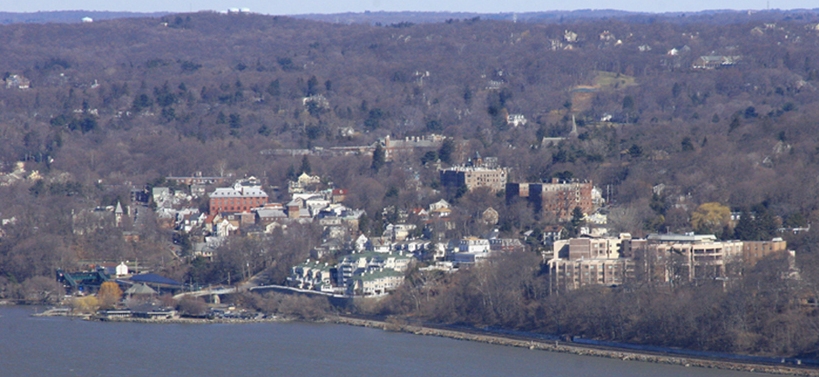


Dobbs Ferry, New York
Dobbs Ferry is a village of 11,443 people in Westchester County, New York.
Why visit Dobbs Ferry
Townapedia lists 48 museums and landmarks, 22 parks and trails, 42 places to eat, 3 places to stay and 5 attractions in and around town.
Highlights include Irvington Town Hall, Rockland Road Bridge, Abner Concklin House and Abraham A. Haring House.
July is the warmest month, with average highs of 86°F; January lows average 23°F, and about 33 inches of snow fall in a normal year.
Weather in Dobbs Ferry
Forecast from the National Weather Service. Full forecast
About Dobbs Ferry
Dobbs Ferry is a village in Westchester County, New York, United States. The population was 10,875 according to the 2010 United States census. In 2021, its population rose to an estimated 11,456. The village of Dobbs Ferry is located in, and is a part of, the town of Greenburgh.
From the Wikipedia article Dobbs Ferry, New York (this version), under CC BY-SA 4.0.
Things to do5

Irvington Town Hall
Cinema and theater · National Register of Historic Places · 2.0 mi
Theatre in Irvington, New York

Rockland Road Bridge
Bridge · National Register of Historic Places · 3.2 mi
Bridge in United States of America

Sparkill Creek Drawbridge
Bridge · National Register of Historic Places · 3.1 mi
Bridge in United States of America

Mercy University
School · 0.9 mi
University in Dobbs Ferry, USA
555 Broadway, Dobbs Ferry
Museums and landmarks48

Abner Concklin House
Monument and historic site · National Register of Historic Places · 2.7 mi
Historic house in Palisades, New York

Abraham A. Haring House
Monument and historic site · National Register of Historic Places · 3.4 mi
House in Rockleigh, New Jersey
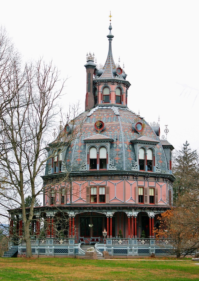
Armour-Stiner House
Monument and historic site · National Register of Historic Places · 1.4 mi
Historic house in Irvington, New York, United States

Big House
Monument and historic site · National Register of Historic Places · 2.3 mi
Historic house in New York, United States
Cliffside
Monument and historic site · National Register of Historic Places · 1.8 mi
Listed on the National Register of Historic Places
Closter Road-Oak Tree Road Historic District
Monument and historic site · National Register of Historic Places · 2.6 mi
Historic house in New York, United States
Concklin-Sneden House
Monument and historic site · National Register of Historic Places · 3.1 mi
Historic house in New Jersey, United States
Dederer Stone House-Stonehurst
Monument and historic site · National Register of Historic Places · 3.2 mi
Historic house in New York, United States

East Irvington School
Monument and historic site · National Register of Historic Places · 2.7 mi
School building in New York, United States of America
Edwin H. Armstrong House
Monument and historic site · National Register of Historic Places · 2.9 mi
Building in New York, United States

Estherwood
Monument and historic site · National Register of Historic Places
Historic mansion on the campus of the Masters School
Ever Rest
Monument and historic site · National Register of Historic Places · 1.4 mi
Historic house in New York, United States
36 more on the map.
Parks, trails and playgrounds22



Untermyer Park
Park · National Register of Historic Places · 3.2 mi
Public garden



10 more on the map.
Restaurants and cafes42

Ardsley Cucina
Restaurant · Italian · 1.5 mi
935 Saw Mill River Road, Ardsley
Mo-Sa 11:00-21:00; Su 11:00-20:00
Ardsley Diner
Restaurant · Diner · 1.3 mi
731 Saw Mill River Road, Ardsley
Mo-Th 10:00-21:00; Fr 10:00-22:00; Sa 08:00-22:00; Su 08:00-21:00
Divino Cucina Italiana
Restaurant · Italian · 1.3 mi
524 Warburton Avenue, Hastings-on-Hudson
Tu-Su 12:00-22:00
Half Moon
Restaurant · American, Seafood · 0.7 mi
1 High Street, Dobbs Ferry
Mo-Th 11:30-15:00,17:30-22:00; Fr 11:30-15:00, 16:00-23:00; Sa...

Harper's Restaurant & Bar
Diner · American · 0.5 mi
92 Main Street, Dobbs Ferry
Tu-Fr 05:00-21:15; Sa, Su 11:30-14:30, 17:00-21:15
La Catena
Restaurant · Italian · 1.5 mi
871 Saw Mill River Road, Ardsley
Mo-Th 15:00-21:45; Fr 15:00-22:45; Sa 12:00-22:45; Su 12:00-21:45
Sam's Italian Ristorante
Restaurant · Italian, Pizza · 0.5 mi
128 Main Street, Dobbs Ferry
11:30-21:30

Starbucks
Cafe · Coffee Shop · 0.8 mi
45 Stanley Avenue, Dobbs Ferry
Mo-Fr 05:30-21:00; Sa, Su 06:00-21:00
Sushi Mike's
Restaurant · Sushi · 0.5 mi
146 Main Street, Dobbs Ferry
Tu-Th, Su 15:00-21:00; Fr, Sa 15:00-21:30
Sushi Niji
Restaurant · Sushi · 0.5 mi
73 Main Street, Dobbs Ferry
Mo, We, Th 11:15-15:15, 16:15-22:00; Fr 11:15-15:15, 16:15-22:30;...
30 more on the map.
History
Multiple groups of Native Americans lived around what is now known as Dobbs Ferry since at least 4500 BC. The most recent tribe who claimed territory of the area are the Wecquaesgeek, maintaining villages until the 1600s. Numerous artifacts from the tribe continue to be found along Wicker's Creek in oyster middens.
Dobbs Ferry was named for the ferry service started in the early 1700s by John Dobbs or his son William. It was not a licensed service, so there are no official records to pin down exactly which Dobbs family member started the service or when. John was English, son of Walter Dobbs who can be found in the historical record getting a liquor license in Manhattan in 1680, leasing land on the East River to harvest salt marsh hay soon after, and serving as a constable in the Bowery Ward. John grew up in Manhattan, the nephew of the wealthy and politically prominent William Merritt, a mariner and businessman. Merritt was mayor of New York from 1695 to 1698 and co-founded Trinity Church (Anglican, now Episcopalian).
From the History section of Dobbs Ferry, New York on Wikipedia, under CC BY-SA 4.0.
Where to stay3
Churches and places of worship11
Christ Church
Church · National Register of Historic Places · 3.3 mi
Church of St. Barnabas
Church · National Register of Historic Places · 2.1 mi
Church of St. Joseph of Arimathea
Church · National Register of Historic Places · 0.4 mi
First Reformed Church
Church · National Register of Historic Places · 3.1 mi
South Presbyterian Church
Church · National Register of Historic Places · 0.4 mi
Our Lady of Perpetual Help Catholic Church
Church · Roman Catholic · 1.3 mi
535 Ashford Avenue, Ardsley
Saint Matthew Catholic Church
Church · Roman Catholic · 1.1 mi
616 Warburton Avenue, Hastings on Hudson
Greenburgh Hebrew Center
Place of worship · Conservative · 0.6 mi
515 Broadway, Dobbs Ferry
Shopping7
Gas and EV charging8
Schools, colleges and libraries50
Healthcare5
Saint John's Riverside Hospital - Dobbs Ferry Pavilion
Hospital · 0.4 mi
128 Ashford Avenue, Dobbs Ferry
Map of Dobbs Ferry
201 places. The map loads OpenStreetMap tiles when you open it.
Climate by month
Monthly table
| Month | High | Low | Rain | Snow |
|---|---|---|---|---|
| Jan | 40°F | 23°F | 3.9 in | 9.4 in |
| Feb | 43°F | 24°F | 3.3 in | 10.9 in |
| Mar | 51°F | 31°F | 4.4 in | 5.8 in |
| Apr | 63°F | 40°F | 4.3 in | 0.7 in |
| May | 73°F | 50°F | 4.3 in | 0.0 in |
| Jun | 81°F | 59°F | 4.6 in | 0.0 in |
| Jul | 86°F | 64°F | 4.5 in | 0.0 in |
| Aug | 84°F | 63°F | 4.4 in | 0.0 in |
| Sep | 77°F | 56°F | 4.6 in | 0.0 in |
| Oct | 65°F | 45°F | 4.4 in | 0.0 in |
| Nov | 54°F | 36°F | 3.9 in | 0.3 in |
| Dec | 44°F | 29°F | 4.7 in | 5.6 in |
U.S. Climate Normals 1991-2020 for Dobbs Ferry-Ardsley Hcn (2 mi away), NOAA NCEI.
People and cost of living
American Community Survey 5-year estimates, 2020-2024, U.S. Census Bureau. Estimates have margins of error, larger for small towns.
Disaster history
Westchester County has had 21 federal disaster declarations since 2000, most often for hurricanes.
- 2024-01-30: Severe Storm And Flooding (Flood)
- 2021-09-05: Remnants Of Hurricane Ida (Hurricane)
- 2021-09-02: Remnants Of Hurricane Ida (Hurricane)
- 2021-08-22: Hurricane Henri (Hurricane)
- 2020-10-02: Tropical Storm Isaias (Hurricane)
- 2020-03-20: Covid-19 Pandemic (Biological)
OpenFEMA disaster declarations summaries.
Getting there and nearby towns
Westchester County Airport (HPN) is the nearest airport with scheduled flights listed in OpenStreetMap, 9 miles away.
- Yonkers 4 mi south, about 7 min by car
- Tenafly 8 mi southwest, about 12 min by car
- Dumont 8 mi southwest, about 13 min by car
- Bergenfield 9 mi southwest, about 15 min by car
- Westwood 9 mi west, about 14 min by car
- New Milford 9 mi southwest, about 15 min by car
- Hillsdale 9 mi west, about 15 min by car
- Englewood 10 mi southwest, about 16 min by car
- River Edge 11 mi southwest, about 17 min by car
- Chestnut Ridge 11 mi northwest, about 17 min by car
Drive times are estimates from straight-line distance, not routes.
Local news
Headlines from INDB, the NEMICO news database.
Reviews, tips and questions
Loading what members have shared...
Sources and licences
- NCES EDGE (Public domain): public schools
- NOAA NCEI U.S. Climate Normals 1991-2020 (Public domain): climate by month
- OpenFEMA (Public domain): disaster declarations
- OpenStreetMap contributors (ODbL 1.0): places, airports, map data
- U.S. Census Bureau (Public domain): population, income, housing, education, commute
- Wikidata (CC0 1.0): elevation, founding date, time zone, website, landmarks and historic places
- Wikimedia Commons (see each image): photos
- Wikipedia (CC BY-SA 4.0): overview and history text
Photo credits
- Dobbsferry2, Ryssby at English Wikipedia, CC BY 3.0
- Sacred Heart Dobbs Ferry front jeh, Jim.henderson, CC BY 4.0
- Chabad of the Rivertowns 303 Bwy Dobbs Ferry jeh, Jim.henderson, CC BY 4.0
- Sacred Heart Dobbs Ferry jeh, Jim.henderson, CC BY 4.0
- Zion Episcopal Church, Dobbs Ferry NY front, KLGates, CC BY-SA 4.0
- Zion Episcopal Church, Dobbs Ferry NY - front with rectory, KLGates, CC BY-SA 4.0
- Zion Episcopal Church, Dobbs Ferry NY - side, KLGates, CC BY-SA 4.0
- Dobbs Ferry MS HS front jeh, Jim.henderson, CC BY 4.0
- Dobbs Ferry station 1920 postcard, Unknown author Unknown author, Public domain
- Greenburgh Hebrew Center Dobbs Ferry jeh, Jim.henderson, CC BY 4.0
- Hudson River, Dobbs Ferry, NY (8033327723), Iliazd, CC BY-SA 2.0
- Barge Dobbs Ferry NY3, Acroterion, CC BY-SA 4.0
- Barge Dobbs Ferry NY2, Acroterion, CC BY-SA 4.0
- Barge Dobbs Ferry NY1, Acroterion, CC BY-SA 4.0
- Alcott School Dobbs Ferry jeh, Jim.henderson, CC BY 4.0
- Dobbs Ferry welcome jeh, Jim.henderson, CC0
- SMRP Ashford exit Dobbs Ferry jeh, Jim.henderson, CC0
- Saw Mill River Parkway nb, Dobbs Ferry, NY, April 2026, Mr. Matté (if there is an issue with this image, contact me using this image's Commons talk page , my Commons user talk page , or my English Wikipedia user talk page ; I'll know about it a lot faster), CC BY-SA 4.0
- CHRIST CHURCH, SPARKILL, ROCKLAND COUNTY, NY, JERRYE & ROY KLOTZ, M.D., CC BY-SA 4.0
- Spanish American War Monument to the 71st Infantry Regiment, Oct 2012, DK Big Fish, Public domain
- FIRST REFORMED CHURCH, PIEDMONT, ROCKLAND COUNTY NY, JERRYE & ROY KLOTZ, M.D., CC BY-SA 4.0
- Rockland ROAD BRIDGE, PIERMONT, ROCKLAND COUNTY, NY, JERRYE & ROY KLOTZ, M.D., CC BY-SA 4.0
- Washington Irving Memorial Irvington, Beyond My Ken, CC BY-SA 4.0
- Untermyer Park and Gardens, Yonkers, NY, Ronala43, CC BY-SA 3.0
- East Irvington School, Beyond My Ken, CC BY 3.0
- ABNER CONCKLIN HOUSE, PALISADES, ROCKLAND COUNTY, NY, JERRYE & ROY KLOTZ, M.D., CC BY-SA 4.0
- Armour-Stiner House (1), csouza_79, CC BY 2.0
- WB Thompson Mansion, Yonkers, NY, Daniel Case, CC BY-SA 3.0
- Joseph Dubois House, Rockleigh, NJ, JERRYE & ROY KLOTZ M.D., CC BY-SA 4.0
- Lyndhurst Tarrytown NY - front facade, Unknown author, CC BY-SA 3.0
- Dobbs Ferry, NY, post office, Daniel Case, CC BY-SA 3.0
- ScarsdalePostOffice, Self made photo, CC BY-SA 3.0
- Estherwood, Dobbs Ferry, NY, Daniel Case, CC BY-SA 3.0
- Piermont Drawbridge, Alexisrael, CC BY-SA 3.0
- Church of St. Joseph of Arimathea, Oct 2012, DK Big Fish, CC0
- ROCKLAND ROAD BRIDGE HISTORIC DISTRICT, PIERMONT, ROCKLAND COUNTY, NY, JERRYE AND ROY KLOTZ, M.D., CC BY-SA 4.0
- ABRAHAM A. HARING HOUSE, ROCKLEIGH, BERGEN COUNTY, NJ, JERRYE & ROY KLOTZ M.D., CC BY-SA 3.0
- NEIDERHURST, PALISADES, ROCKLAND COUNTY, NY, JERRYE & ROY KLOTZ, M.D., CC BY-SA 4.0
- HenryDraperObservatory, Daniel Case, CC BY-SA 3.0
- McVickar House, Irvington, NY, Daniel Case, CC BY-SA 3.0


Page built October 30, 2026. Spotted a mistake? Tell us or suggest a place.