


Dunmore, Pennsylvania
Dunmore is a borough of 14,181 people in Lackawanna County, Pennsylvania, founded in 1783.
Why visit Dunmore
Townapedia lists 51 museums and landmarks, 26 parks and trails, 50 places to eat, 3 places to stay and 9 attractions in and around town.
Highlights include Scranton Cultural Center, Luna Park, Scranton, Ad-Lin Building and Albright Memorial Building.
July is the warmest month, with average highs of 85°F; January lows average 20°F, and about 45 inches of snow fall in a normal year.
Weather in Dunmore
Forecast from the National Weather Service. Full forecast
About Dunmore
Dunmore is a borough in Lackawanna County, Pennsylvania, United States, adjoining Scranton. It is part of Northeastern Pennsylvania and was settled in 1835 and incorporated in 1862. Extensive anthracite coal, brick, stone, and silk interests had led to a rapid increase in the population from 8,315 in 1890 to 23,086 in 1940. The population was 14,042 in the 2020 census.
From the Wikipedia article Dunmore, Pennsylvania (this version), under CC BY-SA 4.0.
Things to do9

Scranton Cultural Center
Cinema and theater · National Register of Historic Places · 3.0 mi
Theater in Scranton, Pennsylvania, USA

Luna Park, Scranton
Monument and historic site · 2.1 mi
Amusement park in Scranton, New Jersey, U.S

University of Scranton
School · 2.8 mi
Private Jesuit university in Scranton, Pennsylvania, USA


Museums and landmarks51

Ad-Lin Building
Monument and historic site · National Register of Historic Places · 3.1 mi
Historic commercial building in Scranton, Pennsylvania, United States

Albright Memorial Building
Monument and historic site · National Register of Historic Places · 3.1 mi
Library in Scranton, Pennsylvania

Century Club of Scranton
Monument and historic site · National Register of Historic Places · 2.8 mi
Building in Pennsylvania, United States

Delaware, Lackawanna and Western Railroad Yard-Dickson Manufacturing Co. Site
Monument and historic site · National Register of Historic Places · 3.5 mi
Historic district in Pennsylvania, United States

Dickson Works
Monument and historic site · National Register of Historic Places · 3.2 mi
Historic industrial building in Scranton, Pennsylvania, United States

Dime Bank Building
Monument and historic site · National Register of Historic Places · 3.3 mi
Scranton, Pennsylvania

Everhart Museum
Museum · 2.3 mi
Art and natural history museum in Scranton, Pennsylvania, U.S.
1901 Mulberry Street, Scranton

Finch Building
Monument and historic site · National Register of Historic Places · 3.1 mi
Historic place in Pennsylvania, United States

Florence Apartments
Monument and historic site · National Register of Historic Places · 2.9 mi
Multifamily residential in Pennsylvania, United States of America
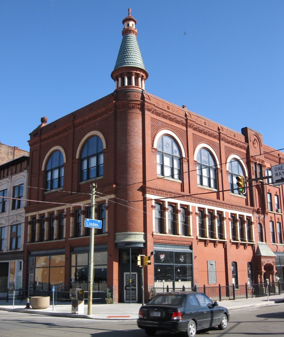
Grand Army of the Republic Building
Monument and historic site · National Register of Historic Places · 3.3 mi
Building in Pennsylvania, United States

Harrison Avenue Bridge
Bridge · National Register of Historic Places · 2.7 mi
Bridge in United States of America
James L. Crawford House
Monument and historic site · National Register of Historic Places · 2.9 mi
Former house in Scranton, Pennsylvania, USA
39 more on the map.
Parks, trails and playgrounds26


Nay Aug Park
Park · 2.2 mi
Public park in Scranton, Pennsylvania, United States
500 Arthur Avenue, Scranton
dawn-20:00


14 more on the map.
Restaurants and cafes50

The Loading Dock Bar & Grill
Restaurant · Grill, Seafood, American · 1.8 mi
1206 O'Neill Highway, Dunmore

Ninas Wing Bites
Restaurant · Pizza, Chicken · 2.4 mi
602 New York Street, Dunmore
Mo-Sa 08:00-20:00

Corleone's Pizzeria
Restaurant · 1.4 mi
514 Chestnut Street, Dunmore

Grande Pizza Restaurant and Bar
Restaurant · Pizza · 1.7 mi
300 South Blakely Street, Dunmore

38 more on the map.
History
The first European to set foot on Dunmore soil was Count Zinzendorf of Saxony, in 1742, as a missionary to the native people who were Munsee-speaking Lenape.
The territory now encompassing Dunmore was purchased from the natives in 1754 by the Susquehanna Company of Connecticut and became the township of Providence. The first settlers of the Dunmore area arrived in 1771 and were originally from Connecticut (see Pennamite–Yankee War). William Allsworth established an inn here in 1783. In the summer of 1795, Charles Dolph, John Carey, and John West began the labor of clearing and plowing lands in the neighborhood of "Bucktown" or "Corners", as this area was called. Edward Lunnon, Isaac Dolph, James Brown, Philip Swartz and Levi De Puy, purchased land here between 1799 and 1805.
Stephen Tripp, in 1820, began the area's first business, erecting a saw and grist mill on the Roaring Brook half a mile south of the village. That same year, the Drinker Turnpike Company opened a store at the Corners. Shortly after Joseph Tanner opened the first blacksmith shop. C.W. Potter opened the first merchandising house in the village in 1845.
From the History section of Dunmore, Pennsylvania on Wikipedia, under CC BY-SA 4.0.
Where to stay3
Four Points by Sheraton Scranton
Motel and hotel · 2.8 mi
300 Meadow Avenue, Scranton
Churches and places of worship24
First Church of Christ, Scientist
Church · National Register of Historic Places · 3.1 mi
St. Peter's Cathedral
Church · National Register of Historic Places · 3.2 mi
Green Ridge Assembly of God
Church · Pentecostal · 2.8 mi
825 Green Ridge Street, Scranton
Holy Trinity Polish National Catholic Church
Church · Catholic · 2.6 mi
619 Center Street, Throop
Ohev Zedek Congregation
Place of worship · Jewish · 2.6 mi
1432 Mulberry Street, Scranton
St Mary-Mt Carmel Church Rctry
Church · Catholic · 1.5 mi
322 Chestnut Street, Dunmore
Shopping6
Gas and EV charging8
Schools, colleges and libraries38
Career Technology Center of Lackawanna County
School · 4.0 mi
3201 Rockwell Avenue, Scranton
Healthcare8
Map of Dunmore
223 places. The map loads OpenStreetMap tiles when you open it.
Climate by month
Monthly table
| Month | High | Low | Rain | Snow |
|---|---|---|---|---|
| Jan | 36°F | 20°F | 2.6 in | 11.7 in |
| Feb | 39°F | 22°F | 2.1 in | 10.9 in |
| Mar | 48°F | 29°F | 2.8 in | 10.1 in |
| Apr | 61°F | 39°F | 3.3 in | 0.8 in |
| May | 72°F | 50°F | 3.3 in | 0.0 in |
| Jun | 80°F | 58°F | 3.8 in | 0.0 in |
| Jul | 85°F | 63°F | 3.6 in | 0.0 in |
| Aug | 82°F | 61°F | 3.9 in | 0.0 in |
| Sep | 75°F | 54°F | 4.2 in | 0.0 in |
| Oct | 63°F | 43°F | 3.7 in | 0.7 in |
| Nov | 51°F | 34°F | 2.9 in | 3.2 in |
| Dec | 40°F | 26°F | 2.8 in | 7.7 in |
U.S. Climate Normals 1991-2020 for Wilkes-Barre Intl Ap 72513 (8 mi away), NOAA NCEI.
People and cost of living
American Community Survey 5-year estimates, 2020-2024, U.S. Census Bureau. Estimates have margins of error, larger for small towns.
Disaster history
Lackawanna County has had 13 federal disaster declarations since 2000, most often for severe storms.
- 2020-03-30: Covid-19 Pandemic (Biological)
- 2020-03-13: Covid-19 (Biological)
- 2018-11-27: Severe Storms And Flooding (Severe Storm)
- 2012-10-29: Hurricane Sandy (Hurricane)
- 2011-09-12: Tropical Storm Lee (Flood)
- 2011-09-08: Remnants Of Tropical Storm Lee (Flood)
OpenFEMA disaster declarations summaries.
Getting there and nearby towns
Wilkes-Barre/Scranton International Airport (AVP) is the nearest airport with scheduled flights listed in OpenStreetMap, 8 miles away.
- Throop 2 mi north, about 3 min by car
- Berwick 42 mi southwest, about 1 h by car
- Binghamton 50 mi north, about 1 h 15 min by car
- Johnson City 53 mi north, about 1 h 30 min by car
- Bloomsburg 53 mi southwest, about 1 h 30 min by car
- Endicott 53 mi northwest, about 1 h 30 min by car
- Phillipsburg 54 mi southeast, about 1 h 30 min by car
- Endwell 54 mi northwest, about 1 h 30 min by car
- Bethlehem 56 mi south, about 1 h 30 min by car
- Hackettstown 56 mi southeast, about 1 h 30 min by car
Drive times are estimates from straight-line distance, not routes.
Local news
Headlines from INDB, the NEMICO news database.
Reviews, tips and questions
Loading what members have shared...
Sources and licences
- NCES EDGE (Public domain): public schools
- NOAA NCEI U.S. Climate Normals 1991-2020 (Public domain): climate by month
- OpenFEMA (Public domain): disaster declarations
- OpenStreetMap contributors (ODbL 1.0): places, airports, map data
- U.S. Census Bureau (Public domain): population, income, housing, education, commute
- Wikidata (CC0 1.0): elevation, founding date, time zone, website, landmarks and historic places
- Wikimedia Commons (see each image): photos
- Wikipedia (CC BY-SA 4.0): overview and history text
Photo credits
- Dunmore, Pennsylvania, Doug Kerr, CC BY-SA 2.0
- PA 347 sb approaching end, Dunmore, Feb. 2026, Mr. Matté (if there is an issue with this image, contact me using this image's Commons talk page , my Commons user talk page , or my English Wikipedia user talk page ; I'll know about it a lot faster), CC BY-SA 4.0
- Dunmore, PA post office, Feb. 2026, Mr. Matté (if there is an issue with this image, contact me using this image's Commons talk page , my Commons user talk page , or my English Wikipedia user talk page ; I'll know about it a lot faster), CC BY-SA 4.0
- PA 347 sb at southern terminus, Dunmore, Feb. 2026, Mr. Matté (if there is an issue with this image, contact me using this image's Commons talk page , my Commons user talk page , or my English Wikipedia user talk page ; I'll know about it a lot faster), CC BY-SA 4.0
- Dunmore PA Muni building and Fire station, Smallbones, CC0
- Sheetz gas station, Dunmore, Pennsylvania - 20221127, Andre Carrotflower, CC BY-SA 4.0
- Everhart Museum and Nay Aug Park, Scranton, Pa (79587), The Mebane Greeting Card Co., Wilkes-Barre, PA., Public domain
- Century Club Scranton PA, Smallbones, CC0
- Harrison Avenue Bridge - March 2015, Adam Moss, CC BY-SA 2.0
- Lackawanna County Courthouse Nov 09, Doug Kerr from Albany, NY, United States, CC BY-SA 2.0
- St. Peter's Cathedral, Christopher Seliga, CC BY-SA 3.0
- Roger Williams Public School No 10 Scranton PA, Smallbones, CC0
- Ad-Lin bldg Scranton PA, Smallbones, CC0
- Central Railroad of New Jersey Freight Station, Scranton, PA, Daniel Case, CC BY-SA 3.0
- Dime Bank 2 Scranton PA, Smallbones, CC0
- PA-Scranton 1931 1 Ref, General Services Administration, Public domain
- Christian Science Scranton PA, Smallbones, CC0
- Main station D,L & W Scranton PA, Smallbones, CC0
- Florence Apts Scranton PA, Smallbones, CC0
- Finch Building, Scranton, PA, Daniel Case, CC BY-SA 3.0
- Scranton - Scranton City Hall (48472742281), Ajay Suresh from New York, NY, USA, CC BY 2.0
- Scranton PA Jr High Main Ave, Smallbones, CC0
- Scranton iron furnaces 2008 03 23, Rolfmueller, CC BY-SA 4.0
- Steamtown Roundhouse, National Park Service, Public domain
- 332-334 Lackawanna Avenue, Scranton, Mark Harrell, Public domain
- Grand Army of the Republic Building Scranton PA Nov 09, Doug Kerr from Albany, NY, United States, CC BY-SA 2.0
- Dickson Works Nov 09, Doug Kerr from Albany, NY, United States, CC BY-SA 2.0
- Tripp House side Scranton PA, Smallbones, CC0
- Delaware, Lackawanna and Western Railroad Yard, Scranton, Mark Harrell, Public domain
- Silkman House, Scranton, Stanley Jones, Public domain
- Terence Powderly House, Daniel Case, CC BY-SA 3.0
- Scranton, PA, Public Library IMG 1519, Billy Hathorn ( talk ), CC BY-SA 3.0
- 426 Mulberry Street Scranton PA, Smallbones, CC0
- Scranton Lace Company Scranton PA, Smallbones, CC0
- U of Scranton - The Commons, Scanlan of English Wikipedia, Public domain
- Ststanislauscathedral, Tomdobb, CC BY-SA 3.0
- I-84 in Pennsylvania, June 11 2026 (01), Dillan Payne, CC BY-SA 4.0
- Exiting the Nay Aug tunnel, just outside of Scranton, Pennsylvania on a winter steam excursion, February 1996, Bruce Fingerhood from Springfield, Oregon, US, CC BY 2.0
- ISS037-E-22337 - View of Earth, Earth Science and Remote Sensing Unit , Lyndon B. Johnson Space Center, Public domain
- ISS047-E-122924 - View of Earth, Earth Science and Remote Sensing Unit , Lyndon B. Johnson Space Center, Public domain


Page built October 30, 2026. Spotted a mistake? Tell us or suggest a place.