


East Falmouth, Massachusetts
East Falmouth is a community of 6,245 people in Barnstable County, Massachusetts.
Why visit East Falmouth
Townapedia lists 9 museums and landmarks, 25 parks and trails, 22 places to eat, 3 places to stay and 2 attractions in and around town.
Highlights include Falmouth Cinema Pub, Falmouth Inner Light, Central Fire Station and Falmouth Pumping Station.
Weather in East Falmouth
Forecast from the National Weather Service. Full forecast
About East Falmouth
East Falmouth is a census-designated place (CDP) in the town of Falmouth in Barnstable, Massachusetts, United States. It is located at the base of Massachusetts' Cape Cod peninsula (see map at right). As of the 2020 census, East Falmouth had a population of 6,278, making it the most populous of the six CDPs in Falmouth.
From the Wikipedia article East Falmouth, Massachusetts (this version), under CC BY-SA 4.0.
Things to do2


Falmouth Inner Light
Lighthouse · 3.2 mi
Lighthouse in Massachusetts, United States
Museums and landmarks9

Central Fire Station
Monument and historic site · National Register of Historic Places · 2.9 mi
Historic fire station at 399 Main Street in Falmouth, Massachusetts, United States

Falmouth Pumping Station
Monument and historic site · National Register of Historic Places · 3.0 mi
Waterworks in Massachusetts, United States of America

Falmouth Village Green Historic District
Monument and historic site · National Register of Historic Places · 3.6 mi
Historic district in Massachusetts, United States

Josiah Tobey House
Monument and historic site · National Register of Historic Places · 1.2 mi
Historic house in Massachusetts, United States

Lawrence Academy
Monument and historic site · National Register of Historic Places · 3.2 mi
School in Falmouth, Massachusetts
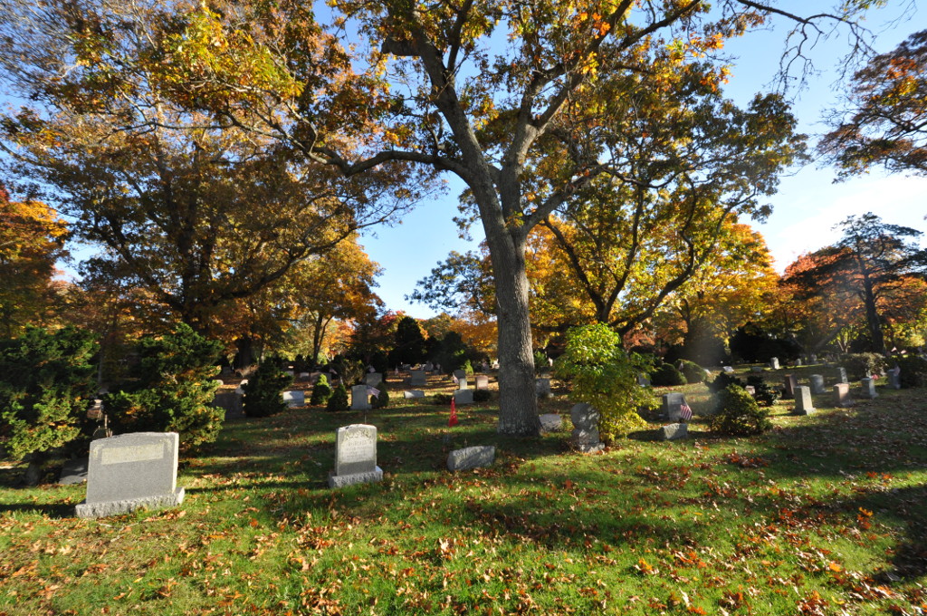
Oak Grove Cemetery
Monument and historic site · National Register of Historic Places · 3.1 mi
Cemetery in Falmouth, Massachusetts

Poor House and Methodist Cemetery
Monument and historic site · National Register of Historic Places · 3.2 mi
Historic burying ground in Falmouth, Barnstable County, Massachusetts

Waquoit Historic District
Monument and historic site · National Register of Historic Places · 2.3 mi
Historic district in Massachusetts, United States

Teaticket School
Monument and historic site · National Register of Historic Places · 2.5 mi
Parks, trails and playgrounds25






13 more on the map.
Restaurants and cafes22

East End Tap
Bar and pub · Burger, Seafood, Pub · 1.4 mi
734 Teaticket Highway, Falmouth
Tu-Sa 11:30-22:00+

Papa Gino's
Restaurant · Pizza · 2.4 mi
Mo-Th 10:30-20:30, Fr-Sa 10:30-21:00, Su 11:00-20:30
Casa Vallarta Mexican Restaurant
Restaurant · Mexican · 2.3 mi
70 Davis Straits, Falmouth

10 more on the map.
Where to stay3
Churches and places of worship2
Shopping9
Gas and EV charging1
Schools, colleges and libraries14
East Falmouth Public Library
Library · 0.8 mi
310 East Falmouth Highway, East Falmouth
Healthcare5
Map of East Falmouth
92 places. The map loads OpenStreetMap tiles when you open it.
People and cost of living
American Community Survey 5-year estimates, 2020-2024, U.S. Census Bureau. Estimates have margins of error, larger for small towns.
Disaster history
Barnstable County has had 16 federal disaster declarations since 2000, most often for hurricanes.
- 2023-09-15: Hurricane Lee (Hurricane)
- 2020-03-27: Covid-19 Pandemic (Biological)
- 2020-03-13: Covid-19 (Biological)
- 2018-06-25: Severe Winter Storm And Flooding (Severe Storm)
- 2015-04-13: Severe Winter Storm, Snowstorm, And Flooding (Severe Storm)
- 2013-04-19: Severe Winter Storm, Snowstorm, And Flooding (Severe Storm)
OpenFEMA disaster declarations summaries.
Getting there and nearby towns
Cape Cod Coast Guard Air Station (FMH) is the nearest airport with scheduled flights listed in OpenStreetMap, 6 miles away.
- Teaticket 2 mi southwest, about 3 min by car
- Falmouth 3 mi southwest, about 5 min by car
- West Falmouth 5 mi northwest, about 8 min by car
- North Falmouth 6 mi northwest, about 10 min by car
- Vineyard Haven 8 mi south, about 13 min by car
- Oak Bluffs 8 mi south, about 13 min by car
- Pocasset 9 mi northwest, about 15 min by car
- Monument Beach 11 mi north, about 17 min by car
- Barnstable Town 12 mi northeast, about 20 min by car
- Bourne 12 mi north, about 19 min by car
Drive times are estimates from straight-line distance, not routes.
Local news
Headlines from INDB, the NEMICO news database.
Reviews, tips and questions
Loading what members have shared...
Sources and licences
- NCES EDGE (Public domain): public schools
- OpenFEMA (Public domain): disaster declarations
- OpenStreetMap contributors (ODbL 1.0): places, airports, map data
- U.S. Census Bureau (Public domain): population, income, housing, education, commute
- Wikidata (CC0 1.0): elevation, founding date, time zone, website, landmarks and historic places
- Wikimedia Commons (see each image): photos
- Wikipedia (CC BY-SA 4.0): overview and history text
Photo credits
- East Branch, Falmouth Public Library, East Falmouth MA, John Phelan, CC BY-SA 4.0
- Falmouth Pumping Station, Falmouth, MA, WestFalmouth, CC BY-SA 3.0
- Central Fire Station, 399 Main Street, Falmouth, MA, WestFalmouth, CC BY-SA 3.0
- Village Green Inn, Falmouth MA, John Phelan, CC BY 3.0
- Falmouth Poor House, 744 Main Street, Falmouth MA, WestFalmouth, CC BY-SA 3.0
- Waquoit Congregational Church, Waquoit MA, John Phelan, CC BY-SA 3.0
- Lawrence Academy, 20 Academy Lane, Falmouth, MA, WestFalmouth, CC BY-SA 3.0
- FalmouthMA OakGroveCemetery1, Magicpiano, CC BY-SA 4.0
- Teaticket School, 340 Teaticket Hwy, Falmouth, MA, WestFalmouth, CC BY-SA 3.0
- Flickr - Per Ola Wiberg ~ mostly away - Windy day on Cape Cod, Per Ola Wiberg from Ekerö, Sweden, CC BY 2.0
- FalmouthMA JosiahTobeyHouse, Magicpiano, CC BY-SA 4.0
- Lycaena phlaeas 142747778, Jake McCumber, CC BY-SA 4.0
- Pandion haliaetus defecating in Massachussets, Kevin Lynch, CC BY 4.0
- Dasymutilla ursus - iNaturalist 521014171, Brighton Lee, CC0
- DSC 0387 (3748530064), Putneypics, CC BY 2.0
- Juvenile osprey (Pandion haliaetus) testing its wings, Waquoit Bay National Estuarine Research Reserve, Maine, US (PPL1-Corrected) julesvernex2-4, Jules Verne Times Two, CC BY-SA 4.0
- Juvenile osprey (Pandion haliaetus) testing its wings, Waquoit Bay National Estuarine Research Reserve, Maine, US (PPL1-Corrected) julesvernex2-3, Jules Verne Times Two, CC BY-SA 4.0
- Juvenile osprey (Pandion haliaetus) testing its wings, Waquoit Bay National Estuarine Research Reserve, Maine, US (PPL1-Corrected) julesvernex2-2, Jules Verne Times Two, CC BY-SA 4.0
- Perched osprey (Pandion haliaetus), Waquoit Bay National Estuarine Research Reserve, Maine, US (PPL1-Corrected) julesvernex2-2, Jules Verne Times Two, CC BY-SA 4.0
- Flying osprey (Pandion haliaetus), Waquoit Bay National Estuarine Research Reserve, Maine, US (PPL1-Corrected) julesvernex2, Jules Verne Times Two, CC BY-SA 4.0
- Perched osprey (Pandion haliaetus), Waquoit Bay National Estuarine Research Reserve, Maine, US (PPL1-Corrected) julesvernex2, Jules Verne Times Two, CC BY-SA 4.0
- Juvenile osprey (Pandion haliaetus) testing its wings, Waquoit Bay National Estuarine Research Reserve, Maine, US (PPL1-Corrected) julesvernex2, Jules Verne Times Two, CC BY-SA 4.0
- Flying osprey (Pandion haliaetus) with prey, Waquoit Bay National Estuarine Research Reserve, Maine, US (PPL1-Corrected) julesvernex2, Jules Verne Times Two, CC BY-SA 4.0
- Flying osprey (Pandion haliaetus), Waquoit Bay National Estuarine Research Reserve, Maine, US (PPL3-Altered) julesvernex2, Jules Verne Times Two, CC BY-SA 4.0
- Juvenile ospreys (Pandion haliaetus) on the nest, Waquoit Bay National Estuarine Research Reserve, Maine, US (PPL1-Corrected) julesvernex2, Jules Verne Times Two, CC BY-SA 4.0
- Perched osprey (Pandion haliaetus), Waquoit Bay National Estuarine Research Reserve, Maine, US (PPL3-Altered) julesvernex2, Jules Verne Times Two, CC BY-SA 4.0
- A classic dry erase board, LucyLightBright, CC BY-SA 4.0
- Boats On Seconsett - panoramio, Pintsmasher, CC BY 3.0
- Beacon from flickr, Putneypics, CC BY 2.0
- Cape Cod, Massachusetts - 5739773944, Dougtone, CC BY-SA 2.0
- Looking at you, Seconsett... - panoramio, Pintsmasher, CC BY 3.0
- From Meadow Neck Road - panoramio, Pintsmasher, CC BY 3.0


Page built October 30, 2026. Spotted a mistake? Tell us or suggest a place.