


Eatontown, New Jersey
Eatontown is a borough of 13,575 people in Monmouth County, New Jersey, founded in April 4, 1873.
Why visit Eatontown
Townapedia lists 22 museums and landmarks, 12 parks and trails, 44 places to eat, 9 places to stay and 7 attractions in and around town.
Highlights include AMC Monmouth Mall 15, Count Basie Theatre, Allen House and Anthony Reckless Estate.
July is the warmest month, with average highs of 84°F; January lows average 25°F.
Weather in Eatontown
Forecast from the National Weather Service. Full forecast
About Eatontown
Eatontown is a borough in Monmouth County, in the U.S. state of New Jersey. As of the 2020 United States census, the borough's population was 13,597, an increase of 888 (+7.0%) from the 2010 census count of 12,709, which in turn reflected a decline of 1,299 (−9.3%) from the 14,008 counted in the 2000 census.
From the Wikipedia article Eatontown, New Jersey (this version), under CC BY-SA 4.0.
Things to do7

AMC Monmouth Mall 15
Cinema and theater
180 NJ 35, Eatontown
Mo-Su 12:00-00:00 "Check website for showings"; PH off
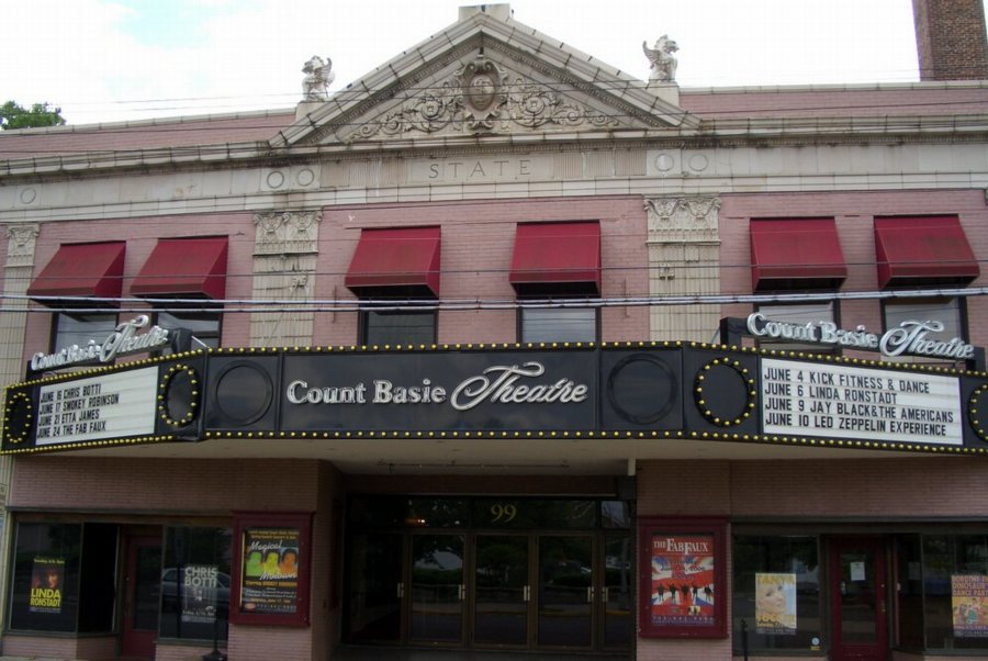
Count Basie Theatre
Cinema and theater · National Register of Historic Places · 4.1 mi
Theater in Red Bank, New Jersey, United States

Kid's World
Monument and historic site · 4.0 mi
Long Branch, New Jersey, USA
Marion Huber Theater
Cinema and theater · 3.5 mi
Smaller stage of the Two River Theater in Red Bank, New Jersey

Monmouth University
School · 2.7 mi
Private university located in West Long Branch, Monmouth County, New Jersey, United States

Two River Theater
Cinema and theater · 4.1 mi
Theater in Red Bank, New Jersey
Museums and landmarks22

Allen House
Monument and historic site · National Register of Historic Places · 2.3 mi
Historic house in Shrewsbury, New Jersey

Anthony Reckless Estate
Monument and historic site · National Register of Historic Places · 3.8 mi
Historic house in Monmouth County, New Jersey

Elberon
Monument and historic site · National Register of Historic Places · 3.5 mi
Train station in New Jersey, United States
House at 364 Cedar Avenue
Monument and historic site · National Register of Historic Places · 2.9 mi
Former historic house in Long Branch, New Jersey

Little Silver
Monument and historic site · National Register of Historic Places · 2.5 mi
NJ Transit rail station

Murry Guggenheim House
Monument and historic site · National Register of Historic Places · 2.8 mi
Historic house in West Long Branch, New Jersey

Parker Homestead
Monument and historic site · National Register of Historic Places · 3.6 mi
Building in New Jersey, United States
Red Bank
Monument and historic site · National Register of Historic Places · 4.1 mi
New Jersey Transit rail station in Red Bank, New Jersey, United States

Shadow Lawn
Monument and historic site · National Register of Historic Places · 2.7 mi
Historic building in West Long Branch, New Jersey
T. Thomas Fortune House
Monument and historic site · National Register of Historic Places · 3.6 mi
Historic house in New Jersey, United States
Wardell House
Monument and historic site · National Register of Historic Places · 2.2 mi
Historic house in New Jersey, United States
Old Mill at Tinton Falls
Monument and historic site · National Register of Historic Places · 2.6 mi
10 more on the map.
Parks, trails and playgrounds12




Restaurants and cafes44

Attilio Ristorante & Pizzeria
Restaurant · Pizza · 1.2 mi
145 Monmouth Road, West Long Branch
Tu-Th 10:30-22:30; Fr,Sa 10:30-23:00; Su 11:00-22:30
Bubbakoo's Burritos
Restaurant · Mexican · 1.2 mi
145 Monmouth Road, West Long Branch
Mo-Su 11:00-21:00
Misu 36 Asian Cuisine
Restaurant · Asian · 1.2 mi
145 Monmouth Road, West Long Branch
Mo-Th 11:30-15:00,16:30-22:00; Fr 11:30-15:00,16:30-22:30; Sa...
Round Dough With a Hole
Restaurant · Bagel, Sandwich · 2.1 mi
700 Oceanport Avenue, Oceanport
Mo-Su 06:00-14:00



Barnes & Noble Café Eatontown
Cafe · Sandwich, Coffee Shop, Bakery
180 NJ 35, Eatontown
Mo-Su 09:00-20:00
32 more on the map.
History
Eatontown's history is documented in the book Eatontown and Fort Monmouth.
In 1670, Thomas Eaton (for which the town is named) surveyed the area and constructed a grist mill in present-day Wampum Lake Park.
By 1796, a village had developed across from Eaton's mill, with a tannery and general store on the east side of the Red Bank Turnpike [now State Route 35]. A tavern for the New York - Philadelphia stage coach trade was built on what would become the intersection of Main and Broad Streets. A second stage coach stop was established in Mechanicsville on the ocean-bound road. This village would later be called West Long Branch.
By 1850, Eaton's village had grown to include four stores on Main Street and nearly forty homes. The Eatontown Steamboat Company built docks on Oceanport Creek to ship milled flour and other farm produce up the South Shrewsbury River to markets in New York City. Entrepreneur James P. Allaire built a four-story stone warehouse at the docks, from which he shipped his bog iron forged at the Howell Works 15 miles away.
From the History section of Eatontown, New Jersey on Wikipedia, under CC BY-SA 4.0.
Where to stay9
Holiday Inn Express & Suites West Long Branch - Eatontown
Motel and hotel · 1.1 mi
294 NJ 36, West Long Branch
Latitude Suites Tinton Falls part of Unscripted by Hyatt
Motel and hotel · 1.4 mi
3 Centre Plaza, Tinton Falls
Homewood Suites by Hilton Eatontown
Motel and hotel · 1.3 mi
4 Industrial Way East
Churches and places of worship23
Christ Church (Episcopal), Shrewsbury
Church · National Register of Historic Places · 2.2 mi
Church of the Presidents
Church · National Register of Historic Places · 3.9 mi
St. James Memorial Church of Eatontown
Church · National Register of Historic Places · 1.0 mi
St. John's Episcopal Church
Church · National Register of Historic Places · 3.1 mi
Saint George Greek Orthodox Church
Church · Greek Orthodox · 2.1 mi
1033 West Park Avenue, Ocean Township
Mount Zion African Methodist Episcopal Zion Church
Church · African Methodist Episcopal Zion · 0.4 mi
Shopping17
Gas and EV charging7
Schools, colleges and libraries60
College Achieve Greater Asbury Park Charter School District
School · 5.8 mi
3455 West Bangs Ave, Neptune
Dr. Martin Luther King Jr. Middle School
School · 5.4 mi
1200 Bangs Avenue, Asbury Park
Healthcare8
The Kaga Academy of Aesthetic and Concierge Medicine
Clinic and pharmacy · 2.4 mi
830 Broad Street, Shrewsbury
Encompass Health Rehabilitation Hospital Of Tinton Falls
Hospital · 1.5 mi
2 Centre Plaza, Tinton Falls
Map of Eatontown
209 places. The map loads OpenStreetMap tiles when you open it.
Climate by month
Monthly table
| Month | High | Low | Rain |
|---|---|---|---|
| Jan | 42°F | 25°F | 4.2 in |
| Feb | 43°F | 26°F | 3.3 in |
| Mar | 49°F | 32°F | 4.3 in |
| Apr | 59°F | 41°F | 3.9 in |
| May | 68°F | 51°F | 4.1 in |
| Jun | 78°F | 61°F | 4.3 in |
| Jul | 84°F | 67°F | 4.4 in |
| Aug | 82°F | 65°F | 6.3 in |
| Sep | 76°F | 59°F | 4.3 in |
| Oct | 66°F | 47°F | 4.7 in |
| Nov | 56°F | 37°F | 3.8 in |
| Dec | 47°F | 30°F | 4.8 in |
U.S. Climate Normals 1991-2020 for Long Branch-Oakhurst Hcn (3 mi away), NOAA NCEI.
People and cost of living
American Community Survey 5-year estimates, 2020-2024, U.S. Census Bureau. Estimates have margins of error, larger for small towns.
Disaster history
Monmouth County has had 16 federal disaster declarations since 2000, most often for hurricanes.
- 2021-09-05: Remnants Of Hurricane Ida (Hurricane)
- 2021-09-02: Remnants Of Hurricane Ida (Hurricane)
- 2020-12-11: Tropical Storm Isaias (Hurricane)
- 2020-03-25: Covid-19 Pandemic (Biological)
- 2020-03-13: Covid-19 (Biological)
- 2016-03-14: Severe Winter Storm And Snowstorm (Severe Storm)
OpenFEMA disaster declarations summaries.
Getting there and nearby towns
Monmouth Executive Airport (BLM) is the nearest airport with scheduled flights listed in OpenStreetMap, 8 miles away.
- Asbury Park 5 mi southeast, about 9 min by car
- New York 26 mi north, about 42 min by car
- Beachwood 26 mi south, about 42 min by car
- Elizabeth 27 mi north, about 43 min by car
- Jersey City 29 mi north, about 47 min by car
- Newark 31 mi north, about 49 min by car
- Blackwells Mills 31 mi northwest, about 51 min by car
- Bound Brook 32 mi northwest, about 51 min by car
- Bradley Gardens 37 mi northwest, about 1 h by car
- Paterson 43 mi north, about 1 h 15 min by car
Drive times are estimates from straight-line distance, not routes.
Local news
Headlines from INDB, the NEMICO news database.
Reviews, tips and questions
Loading what members have shared...
Sources and licences
- NCES EDGE (Public domain): public schools
- NOAA NCEI U.S. Climate Normals 1991-2020 (Public domain): climate by month
- OpenFEMA (Public domain): disaster declarations
- OpenStreetMap contributors (ODbL 1.0): places, airports, map data
- U.S. Census Bureau (Public domain): population, income, housing, education, commute
- Wikidata (CC0 1.0): elevation, founding date, time zone, website, landmarks and historic places
- Wikimedia Commons (see each image): photos
- Wikipedia (CC BY-SA 4.0): overview and history text
Photo credits
- Eatontown, NJ - Route 71 at 35, Mr. Matté (if there is an issue with this image, contact me using this image's Commons talk page , my Commons user talk page , or my English Wikipedia user talk page ; I'll know about it a lot faster), CC BY 3.0
- 2018-05-26 18 17 24 View north along Monmouth County Route 547 (Wyckoff Road) at Laurel Place in Eatontown, Monmouth County, New Jersey, Famartin, CC BY-SA 4.0
- 2020-09-10 11 02 28 View west along New Jersey State Route 36 at the exit for Monmouth County Route 547 NORTH in Eatontown, Monmouth County, New Jersey, Famartin, CC BY-SA 4.0
- 2020-09-10 11 21 22 View east along New Jersey State Route 36 at the exit for New Jersey State Route 35 SOUTH (Asbury Park, Seaside Heights) in Eatontown, Monmouth County, New Jersey, Famartin, CC BY-SA 4.0
- 2020-09-14 09 38 47 View south along New Jersey State Route 35 (Neptune Boulevard) at New Jersey State Route 36 in Eatontown, Middlesex County, New Jersey, Famartin, CC BY-SA 4.0
- 2020-09-14 09 33 38 View south along New Jersey State Route 35 (Neptune Boulevard) just north of New Jersey State Route 36 in Eatontown, Middlesex County, New Jersey, Famartin, CC BY-SA 4.0
- 2020-09-10 11 05 59 View west along New Jersey State Route 36 at the exit for Monmouth County Route 547 SOUTH (Laurel Place, Shopping Center) in Eatontown, Monmouth County, New Jersey, Famartin, CC BY-SA 4.0
- 2020-09-13 16 09 40 View north along New Jersey State Route 35 (Neptune Boulevard) at New Jersey State Route 36 in Eatontown, Middlesex County, New Jersey, Famartin, CC BY-SA 4.0
- 2020-09-10 10 58 12 View west along New Jersey State Route 36 at the exit for New Jersey State Route 35 NORTH (Fort Monmouth, Red Bank, The Amboys) in Eatontown, Monmouth County, New Jersey, Famartin, CC BY-SA 4.0
- 2020-09-10 11 23 08 View east along New Jersey State Route 36 at the exit for New Jersey State Route 35 NORTH (Fort Monmouth, Red Bank, The Amboys) in Eatontown, Monmouth County, New Jersey, Famartin, CC BY-SA 4.0
- 2020-09-10 11 23 29 View east along New Jersey State Route 36 just east of the exit for New Jersey State Route 35 NORTH (Fort Monmouth, Red Bank, The Amboys) in Eatontown, Monmouth County, New Jersey, Famartin, CC BY-SA 4.0
- 2020-11-05 16 34 49 View north along Monmouth County Route 547 (Wyckoff Road) at New Jersey State Route 36 in Eatontown, Monmouth County, New Jersey, Famartin, CC BY-SA 4.0
- 2020-09-10 11 18 13 View east along New Jersey State Route 36 at the exit for New Jersey State Route 35-Monmouth County Route 547 NORTH (Fort Monmouth, Red Bank) in Eatontown, Monmouth County, New..., Famartin, CC BY-SA 4.0
- 2020-09-13 16 05 01 View north along New Jersey State Route 35 (Neptune Boulevard) at the exit for New Jersey State Route 36 EAST (Long Branch) in Eatontown, Middlesex County, New Jersey, Famartin, CC BY-SA 4.0
- 2018-05-26 14 12 05 View north along New Jersey State Route 35 between Parker Road and New Jersey State Route 36 in Eatontown, Monmouth County, New Jersey, Famartin, CC BY-SA 4.0
- 2020-09-13 16 00 27 View north along New Jersey State Route 35 (Neptune Boulevard) just south of the the exit for New Jersey State Route 36 EAST (Long Branch) in Eatontown, Middlesex County, New..., Famartin, CC BY-SA 4.0
- 2018-05-25 13 33 29 View west along New Jersey State Route 36 just east of Marin Way in Eatontown, Monmouth County, New Jersey, Famartin, CC BY-SA 4.0
- 2020-09-10 11 08 07 View west along New Jersey State Route 36 at the exit for New Jersey State Route 18 (Point Pleasant, New Brunswick) in Eatontown, Monmouth County, New Jersey, Famartin, CC BY-SA 4.0
- Flock ALPR with Solar Panel, Facing Right, Eatontown NJ (July 2026), MiracleMiles, CC BY 4.0
- Flock ALPR with Solar Panel, Closeup Facing Right, Eatontown NJ (July 2026), MiracleMiles, CC BY 4.0
- Flock ALPR with Solar Panel, Facing Left with Trees, Eatontown NJ (July 2026), MiracleMiles, CC BY 4.0
- 2018-05-26 16 16 33 View south along New Jersey State Route 35 (Main Street) at New Jersey State Route 71 and Monmouth County Route 537 (Broad Street) in Eatontown, Monmouth County, New Jersey, Famartin, CC BY-SA 4.0
- 2018-05-25 13 18 53 View south along New Jersey State Route 71 and east along Monmouth County Route 537 (Broad Street) at New Jersey State Route 35 (Main Street) in Eatontown, Monmouth County, New..., Famartin, CC BY-SA 4.0
- Eatontown, NJ Public Library, April 2026, Mr. Matté (if there is an issue with this image, contact me using this image's Commons talk page , my Commons user talk page , or my English Wikipedia user talk page ; I'll know about it a lot faster), CC BY-SA 4.0
- Eatontown, NJ Fire Department, April 2026, Mr. Matté (if there is an issue with this image, contact me using this image's Commons talk page , my Commons user talk page , or my English Wikipedia user talk page ; I'll know about it a lot faster), CC BY-SA 4.0
- 2020-10-10 17 10 23 View east along Monmouth County Route 537 (Lewis Street) at the exit for New Jersey State Route 71 (Oceanport) in Eatontown, Monmouth County, New Jersey, Famartin, CC BY-SA 4.0
- Eatontown, NJ Municipal Building, April 2026, Mr. Matté (if there is an issue with this image, contact me using this image's Commons talk page , my Commons user talk page , or my English Wikipedia user talk page ; I'll know about it a lot faster), CC BY-SA 4.0
- 2018-05-26 14 18 21 View north along New Jersey State Route 35 and west along Monmouth County Route 537 (Main Street) at Lewis Street in Eatontown, Monmouth County, New Jersey, Famartin, CC BY-SA 4.0
- St. James Memorial Episcopal Church, Eatontown, NJ, April 2026, Mr. Matté (if there is an issue with this image, contact me using this image's Commons talk page , my Commons user talk page , or my English Wikipedia user talk page ; I'll know about it a lot faster), CC BY-SA 4.0
- AllenHouseShrewsburyNJ, ClassicLady, CC BY-SA 3.0
- Churchofthepresidents, Original uploaded by K72ndst (Transfered by PHansen ), CC BY 2.5
- Elberon Station, Adam Moss, CC BY-SA 2.0
- Basie theatre, Wikijazz at English Wikipedia, Public domain
- St. James Memorial Church of Eatontown, akaBuddy, CC BY-SA 3.0
- Episcopalian church in Shrewsbury New Jersey on Route 35, Tomwsulcer, CC0
- LSticketbooth, Wikijazz at English Wikipedia, Public domain
- Anthony Reckless Estate, Red Bank, New Jersey (3969287329), Jazz Guy from New Jersey, United States, CC BY 2.0
- Murry Guggenheim House, West Long Branch, NJ - south view, Zeete, CC BY-SA 4.0
- Parker Homestead (1), Apc106, CC BY-SA 3.0
- Woodrow Wilson Hall, West Long Branch, NJ - south view, Zeete, CC BY-SA 4.0


Page built October 30, 2026. Spotted a mistake? Tell us or suggest a place.