
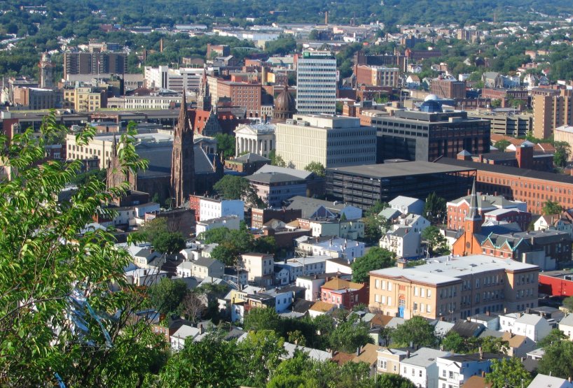


Paterson, New Jersey
Paterson is a city of 158,735 people in Passaic County, New Jersey, founded in 1792.
Why visit Paterson
Townapedia lists 63 museums and landmarks, 58 parks and trails, 196 places to eat, 1 place to stay and 13 attractions in and around town.
Highlights include Great Falls, Capitol Theatre, Eastside Park and Hinchliffe Stadium.
July is the warmest month, with average highs of 86°F; January lows average 22°F.
Weather in Paterson
Forecast from the National Weather Service. Full forecast
About Paterson
Paterson (English pronunciation: /ˈpætɚsən/ ) is the largest city in and the county seat of Passaic County, in the North Jersey region of the U.S. state of New Jersey. As of the 2020 United States census, Paterson was the state's third-most-populous municipality, with a population of 159,732, an increase of 13,533 (+9.3%) from the 2010 census count of 146,199, which in turn reflected a decline of 3,023 (-2.0%) from the 149,222 counted in the 2000 census. The Census Bureau's Population Estimates Program calculated a population of 161,793 for 2025, making it the 165th-most populous municipality in the nation.
From the Wikipedia article Paterson, New Jersey (this version), under CC BY-SA 4.0.
Things to do13


Capitol Theatre
Cinema and theater · 3.9 mi
Former movie theater in Passaic, New Jersey, United States

Hillery Street Bridge
Bridge · 2.1 mi
Vehicular bridge over the Passaic River in Totowa and Woodland Park, New Jersey
Market Street Bridge
Bridge · 4.5 mi
Bridge in Passaic & Wallington, New Jersey
Monroe Street Bridge
Bridge · 4.1 mi
Bridge in Passaic and Garfield, New Jersey, United States

Montclair State University
School · 4.3 mi
Public university in New Jersey, United States
Passaic Street Bridge
Bridge · 4.4 mi
Steel girder road bridge across the Lower Passaic River in northern New Jersey
Sixth Avenue Bridge
Bridge · 1.4 mi
Bridge in United States of America
West Broadway Bridge
Bridge · 0.8 mi
Bridge in United States of America
William Paterson University
School · 2.9 mi
University in New Jersey, United States

1 more on the map.
Museums and landmarks63

Eastside Park
Monument and historic site · National Register of Historic Places · 1.2 mi
Historic district in Paterson, New Jersey

Hinchliffe Stadium
Monument and historic site · National Register of Historic Places · 1.0 mi
Stadium in New Jersey

Lambert Castle
Monument and historic site · National Register of Historic Places · 1.1 mi
Historic building in Paterson, New Jersey
Paterson City Hall
Monument and historic site · National Register of Historic Places · 0.5 mi
Historic city hall in Paterson, New Jersey


Ackerman House
Monument and historic site · National Register of Historic Places · 4.4 mi
House at 222 Doremus Avenue in Ridgewood, New Jersey
Ackerman House
Monument and historic site · National Register of Historic Places · 4.4 mi
House at 252 Lincoln Avenue in Ridgewood, New Jersey
Ackerman-Hopper House
Monument and historic site · National Register of Historic Places · 4.0 mi
Historic house in Bergen County, New Jersey
Ailsa Farms
Monument and historic site · National Register of Historic Places · 2.7 mi
Mansion in Wayne, New Jersey
Andrew H. Hopper House
Monument and historic site · National Register of Historic Places · 4.0 mi
Historic house in Bergen County, New Jersey
Arch Street Bridge
Monument and historic site · National Register of Historic Places · 0.7 mi
Bridge in United States of America
Botany Worsted Mills Historic District
Monument and historic site · National Register of Historic Places · 3.6 mi
Historic district in New Jersey, United States
Cadmus-Folly House
Monument and historic site · National Register of Historic Places · 2.6 mi
Historic house in New Jersey, United States
51 more on the map.
Parks, trails and playgrounds58

Garret Mountain Reservation
Park · 1.3 mi
Public park in Passaic County, New Jersey
Kings Pond Park
Park · 4.5 mi
Park in New Jersey, United States of America
Peckman Preserve
Park · 4.1 mi
Park in New Jersey, United States of America
San Cap Park
Park · 2.3 mi
Park in New Jersey, United States of America
Roberto Clemente Park
Park
Formerly known as Sandy Hill Park; renamed to honor Puerto Rican baseball player Roberto Clemente shortly after his death.
46 more on the map.
Restaurants and cafes196

Coffee Garden
Cafe · Coffee Shop · 2.0 mi
73 Broadway, Elmwood Park
Mo-Fr 08:00-19:00; Sa 08:00-16:00; Su off
Haus Café
Cafe · Coffee Shop · 2.0 mi
12-54 River Road, Fair Lawn
Mo-Fr 07:00-16:00; Sa,Su 08:00-15:00
Java Nut
Cafe · Coffee Shop · 2.6 mi
22 Morlot Avenue
Mo-Th 07:00-15:00; Fr 07:00-13:00; Su 07:00-14:00

Puzo's Family Restaurant
Restaurant · Italian, Pizza · 2.6 mi
4 Garfield Avenue, Hawthorne
Mo-Fr 11:00-22:00; Su 12:00-22:00
Simmi's Table
Restaurant · Indian · 2.6 mi
409 Lafayette Avenue, Hawthorne
Mo,Tu,Th 11:00-18:00; We,Fr 11:00-19:00; Sa 11:00-14:00
Stefano's Pizza & Pasta
Restaurant · Pizza, Pasta · 2.0 mi
71 Broadway, Elmwood Park
Mo-Sa 11:00-24:00; Su 12:00-20:00
Darna Resturant
Restaurant · Middle Eastern · 1.7 mi
1090 Main Street, Paterson
Mo-Su 12:00-23:00; Fr,Sa 12:00-24:00


Nouri's Restaurant
Restaurant · Lebanese, Mediterranean · 1.5 mi
1003 Main Street, Paterson
Mo-Th 08:00-20:00; Fr-Sa 08:00-21:00; Su 09:00-19:00
Al Mazaq Restaurant and Bakery
Restaurant · Arab · 1.1 mi
46 East Railway Avenue
Tu-Su 10:00-20:00
184 more on the map.
History
The area of Paterson was inhabited by the Algonquian-speaking Native American Acquackanonk tribe of the Lenape, also known as the Delaware Indians. The land was known as the Lenapehoking. The Dutch claimed the land as New Netherlands, followed by the British as the Province of New Jersey.
From the History section of Paterson, New Jersey on Wikipedia, under CC BY-SA 4.0.
Where to stay1
Churches and places of worship131
St. John's Evangelical Lutheran Church
Church · National Register of Historic Places · 3.7 mi
Saint John the Baptist Orthodox Church
Church · Serbian Orthodox · 1.5 mi
119 Carlisle Avenue, Paterson
Saint Michael the Archangel Church
Church · Roman Catholic · 0.6 mi
70 Cianci Street, Paterson
Shopping38
Gas and EV charging22
Schools, colleges and libraries127
Maurice M Pine Free Public Library
Library · 2.2 mi
10-01 Fair Lawn Avenue, Fair Lawn
Healthcare20
Medical Imaging Center Of North Jersey Inc.
Clinic and pharmacy · 2.6 mi
1111 Paulison Avenue, Clifton
Map of Paterson
250 places. The map loads OpenStreetMap tiles when you open it.
Climate by month
Monthly table
| Month | High | Low | Rain |
|---|---|---|---|
| Jan | 39°F | 22°F | 3.6 in |
| Feb | 41°F | 23°F | 3.0 in |
| Mar | 50°F | 31°F | 4.2 in |
| Apr | 63°F | 40°F | 4.3 in |
| May | 73°F | 50°F | 4.0 in |
| Jun | 82°F | 60°F | 4.6 in |
| Jul | 86°F | 65°F | 4.6 in |
| Aug | 84°F | 64°F | 4.7 in |
| Sep | 76°F | 56°F | 4.5 in |
| Oct | 65°F | 44°F | 4.2 in |
| Nov | 54°F | 35°F | 3.4 in |
| Dec | 44°F | 27°F | 4.3 in |
U.S. Climate Normals 1991-2020 for Little Falls (4 mi away), rain and snow from Hawthorne 1.0 Sse, NOAA NCEI.
People and cost of living
American Community Survey 5-year estimates, 2020-2024, U.S. Census Bureau. Estimates have margins of error, larger for small towns.
Disaster history
Passaic County has had 20 federal disaster declarations since 2000, most often for hurricanes.
- 2021-09-05: Remnants Of Hurricane Ida (Hurricane)
- 2021-09-02: Remnants Of Hurricane Ida (Hurricane)
- 2020-03-25: Covid-19 Pandemic (Biological)
- 2020-03-13: Covid-19 (Biological)
- 2018-06-08: Severe Winter Storm And Snowstorm (Severe Storm)
- 2012-10-30: Hurricane Sandy (Hurricane)
OpenFEMA disaster declarations summaries.
Getting there and nearby towns
Teterboro Airport (TEB) is the nearest airport with scheduled flights listed in OpenStreetMap, 7 miles away.
- Newark 13 mi south, about 21 min by car
- Jersey City 15 mi south, about 24 min by car
- Yonkers 16 mi east, about 25 min by car
- Elizabeth 17 mi south, about 28 min by car
- New York 21 mi southeast, about 34 min by car
- Greenwich 29 mi east, about 47 min by car
- Stamford 34 mi east, about 55 min by car
- Norwalk 41 mi east, about 1 h by car
- Danbury 49 mi northeast, about 1 h 15 min by car
- Bridgeport 54 mi east, about 1 h 30 min by car
Drive times are estimates from straight-line distance, not routes.
Local news
Headlines from INDB, the NEMICO news database.
Reviews, tips and questions
Loading what members have shared...
Sources and licences
- NCES EDGE (Public domain): public schools
- NOAA NCEI U.S. Climate Normals 1991-2020 (Public domain): climate by month
- OpenFEMA (Public domain): disaster declarations
- OpenStreetMap contributors (ODbL 1.0): places, airports, map data
- U.S. Census Bureau (Public domain): population, income, housing, education, commute
- Wikidata (CC0 1.0): elevation, founding date, time zone, website, landmarks and historic places
- Wikimedia Commons (see each image): photos
- Wikipedia (CC BY-SA 4.0): overview and history text
Photo credits
- Downtown-paterson-nj2, BJT11091, CC BY-SA 3.0
- Paterson Armory SW corner 2015 jeh, Jim.henderson, CC BY 3.0
- Paterson Armory from west door jeh, Jim.henderson, CC BY 3.0
- Paterson Armory west wall demolition, Jim.henderson, CC0
- Paterson Armory south wall 2014 jeh, Jim.henderson, CC BY 3.0
- Paterson Armory burnt floor jeh, Jim.henderson, CC BY 3.0
- Armory demolition in Paterson jeh, Jim.henderson, CC0
- Paterson Armory SW bastion, Jim.henderson, CC BY 3.0
- Paterson Armory west wall, Jim.henderson, CC BY 3.0
- Paterson Station, User:NHRHS2010, Public domain
- Paterson Station from memorial park jeh, I, the copyright holder of this work, hereby publish it under the following license:, Public domain
- Paterson Armory ceiling burnt away jeh, Jim.henderson, CC BY 3.0
- Paterson NJT Station - Street Level, Javierbaires1 at English Wikipedia, Public domain
- Paterson Armory keystone, Jim.henderson, CC BY 3.0
- Paterson Armory SE gate, Jim.henderson, CC BY 3.0
- Paterson Armory SE corner, Jim.henderson, CC BY 3.0
- United Presbyterian Ch of Paterson jeh, Jim.henderson, CC BY 3.0
- PatersonNJ CookeHouse, Cheek Funeral Home, Public domain
- Autobody Jobbers Warehouse Park Av Paterson jeh, Jim.henderson, CC BY 3.0
- Passaic County Court House - Paterson, New Jersey, Farragutful, CC BY-SA 4.0
- Greetings from Paterson, New Jersey - Large Letter Postcard (6311798040), Steve Shook from Moscow, Idaho, USA, CC BY 2.0
- United States Custom House and Post Office - Paterson, Farragutful, CC BY-SA 4.0
- Cathedral of St. John the Baptist Evangelization Center - Paterson, New Jersey, Farragutful, CC BY-SA 4.0
- Cathedral of St. John the Baptist Rectory - Paterson, New Jersey, Farragutful, CC BY-SA 4.0
- Paterson City Hall 2008 jeh, Jim.henderson, Public domain
- Agape Christian Ministries - Paterson, New Jersey, Farragutful, CC BY-SA 4.0
- Cathedral of St. John the Baptist - Paterson, New Jersey 03, Farragutful, CC BY-SA 4.0
- Cathedral of St. John the Baptist - Paterson, New Jersey 02, Farragutful, CC BY-SA 4.0
- Cathedral of St. John the Baptist - Paterson, New Jersey 05, Farragutful, CC BY-SA 4.0
- Cathedral of St. John the Baptist - Paterson, New Jersey, Farragutful, CC BY-SA 4.0
- Cathedral of St. John the Baptist - Paterson, New Jersey 04, Farragutful, CC BY-SA 4.0
- Lambert Castle, Paterson, NJ - looking northwest, Zeete, CC BY-SA 4.0
- Hinchliffe Stadium July 2023, Oknazevad, CC BY-SA 4.0
- HENDRIK HOPPER HOUSE, GLEN ROCK, BERGEN COUNTY, J, CC BY-SA 4.0
- 110142pv, 1. Historic American Buildings Survey R. Merritt Lacey, Photographer April 11, 1938 EXTERIOR - SOUTHWEST CORNER - Jacob Vanderbeck House & Kitchen, Saddle River Road & Dunker Hook Lane, Fair Lawn..., Public domain
- ST. NICHOLAS ROMAN CATHOLIC CHURCH, PASSAIC COUNTY NJ, JERRYE & ROY KLOTZ, M.D., CC BY-SA 4.0
- VAN HOUTEN-HILLMAN HOUSE, ELMWOOD PARK, BERGEN COUNTY NJ, JERRYE & ROY KLOTZ, M.D., CC BY-SA 4.0
- ACKERMAN HOUSE 222 DOREMUS AVENUE, RIDGEWOOD, BERGEN COUNTY NJ, J, CC BY-SA 4.0
- PatersonNJ JohnFergusonHouse, New Jersey Office of Historic Preservation, Public domain
- ST. JOHN'S EVANGELICAL LUTHERN CHURCH, PASSAIC COUNTY, NJ, JERRYE & ROY KLOTZ, M.D., CC BY-SA 4.0


Page built October 30, 2026. Spotted a mistake? Tell us or suggest a place.