


Why visit Abu Simbel
Townapedia lists 7 museums and landmarks, 7 places to eat and 8 places to stay in and around town.
Highlights include Abu Simbel and Great Temple.
Weather in Abu Simbel
Forecast from MET Norway (CC BY 4.0). Full forecast
About Abu Simbel
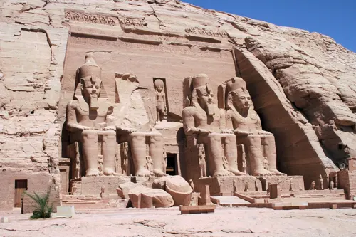
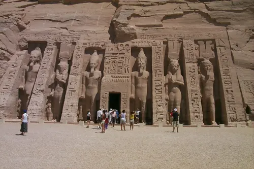
Abu Simbel (also Abu Simbal, Ebsambul or Isambul; Arabic: أبو سنبل, romanized: Abū Sinbal or Arabic: أبو سمبل, romanized: Abū Simbal) is a village in the Egyptian part of Nubia, located approximately 240 km (150 mi) southwest of Aswan and near the Egypt–Sudan border. As of 2012, it has about 2,600 inhabitants. It is best known as the site of the Abu Simbel temples, which were built by King Ramses II.
From the Wikipedia article Abu Simbel (village) (this version), under CC BY-SA 4.0.
Museums and landmarks7

Abu Simbel
Monument and historic site · 1.4 km
UNESCO World Heritage Site in southern Egypt




Restaurants and cafes7



Where to stay8

Churches and places of worship1

Healthcare1
Map of Abu Simbel
24 places. The map loads OpenStreetMap tiles when you open it.
Getting there and nearby towns
Abu Simbel Airport (ABS) is the nearest airport with scheduled flights listed in OpenStreetMap, 3 km away.
Local news
Headlines from INDB.
Reviews, tips and questions
Loading what members have shared...
Sources and licences
- GeoNames (CC BY 4.0): population, coordinates, regions and time zone
- OpenStreetMap contributors (ODbL 1.0): places, airports, map data
- Openverse (see each image): photos
- Wikidata (CC0 1.0): elevation, founding date, time zone, website, landmarks and historic places
- Wikimedia Commons (see each image): photos
- Wikipedia (CC BY-SA 4.0): overview and history text
Photo credits
- AbuSimbelBothTemples, Roland Unger, CC BY-SA 4.0
- Abu Simbel in 2017 , photo by Hatem Moushir 124, Hatem Moushir, CC BY-SA 4.0
- Abu Simbel , photo by Hatem Moushir 14, Hatem Moushir, CC BY-SA 4.0
- Abu Simbel in 2017 , photo by Hatem Moushir 31, Hatem Moushir, CC BY-SA 4.0
- Abu Simbel in 2017 , photo by Hatem Moushir 32, Hatem Moushir, CC BY-SA 4.0
- Abu Simbel in 2017 , photo by Hatem Moushir 30, Hatem Moushir, CC BY-SA 4.0
- Abu Simbel , photo by Hatem Moushir 15, Hatem Moushir, CC BY-SA 4.0
- Abu Simbel in 2017 , photo by Hatem Moushir 29, Hatem Moushir, CC BY-SA 4.0
- Abu Simbel , photo by Hatem Moushir 16, Hatem Moushir, CC BY-SA 4.0
- Abu Simbel in 2017 , photo by Hatem Moushir 170, Hatem Moushir, CC BY-SA 4.0
- Abu Simbel in 2017 , photo by Hatem Moushir 154, Hatem Moushir, CC BY-SA 4.0
- Abu Simbel , photo by Hatem Moushir 17, Hatem Moushir, CC BY-SA 4.0
- Abu Simbel in 2017 , photo by Hatem Moushir 171, Hatem Moushir, CC BY-SA 4.0
- Abu Simbel in 2017 , photo by Hatem Moushir 28, Hatem Moushir, CC BY-SA 4.0
- Abu Simbel , photo by Hatem Moushir 11, Hatem Moushir, CC BY-SA 4.0
- Abu Simbel , photo by Hatem Moushir 10, Hatem Moushir, CC BY-SA 4.0
- Abu Simbel in 2017 , photo by Hatem Moushir 198, Hatem Moushir, CC BY-SA 4.0
- Abu Simbel , photo by Hatem Moushir 8, Hatem Moushir, CC BY-SA 4.0
- Abu Simbel , photo by Hatem Moushir 9, Hatem Moushir, CC BY-SA 4.0
- Abu Simbel in 2017 , photo by Hatem Moushir 199, Hatem Moushir, CC BY-SA 4.0
- Abu Simbel , photo by Hatem Moushir 7, Hatem Moushir, CC BY-SA 4.0
- Abu Simbel , photo by Hatem Moushir 6, Hatem Moushir, CC BY-SA 4.0
- Abu Simbel , photo by Hatem Moushir 5, Hatem Moushir, CC BY-SA 4.0
- Abu Simbel in 2017 , photo by Hatem Moushir 106, Hatem Moushir, CC BY-SA 4.0
- Abu Simbel , photo by Hatem Moushir 4, Hatem Moushir, CC BY-SA 4.0
- Abu Simbel in 2017 , photo by Hatem Moushir 80, Hatem Moushir, CC BY-SA 4.0
- Abu Simbel in 2017 , photo by Hatem Moushir 56, Hatem Moushir, CC BY-SA 4.0
- Abu Simbel , photo by Hatem Moushir 18, Hatem Moushir, CC BY-SA 4.0
- Abu Simbel , photo by Hatem Moushir 12, Hatem Moushir, CC BY-SA 4.0
- Abu Simbel in 2017 , photo by Hatem Moushir 107, Hatem Moushir, CC BY-SA 4.0
- Abu Simbel in 2017 , photo by Hatem Moushir 131, Hatem Moushir, CC BY-SA 4.0
- Abu Simbel in 2017 , photo by Hatem Moushir 132, Hatem Moushir, CC BY-SA 4.0
- Abu Simbel in 2017 , photo by Hatem Moushir 81, Hatem Moushir, CC BY-SA 4.0
- Abu Simbel in 2017 , photo by Hatem Moushir 103, Hatem Moushir, CC BY-SA 4.0
- Abu Simbel , photo by Hatem Moushir 13, Hatem Moushir, CC BY-SA 4.0
- Abu Simbel in 2017 , photo by Hatem Moushir 104, Hatem Moushir, CC BY-SA 4.0
- Abu Simbel in 2017 , photo by Hatem Moushir 188, Hatem Moushir, CC BY-SA 4.0
- Abu Simbel in 2017 , photo by Hatem Moushir 33, Hatem Moushir, CC BY-SA 4.0
- Abu Simbel in 2017 , photo by Hatem Moushir 34, Hatem Moushir, CC BY-SA 4.0
- Großer Tempel (Abu Simbel) 31, Olaf Tausch, Public domain
- Templo de Ramsés II, Abu Simbel, Egipto, 2022-04-02, DD 03, Diego Delso, CC BY-SA 4.0
- Abu Simbel Small temple 2, Ad Meskens, CC BY-SA 3.0
- Temple of Ramesses II, Abu Simbel, Son of Groucho, CC BY 2.0
- Ramses' temple to Nefertari, Abu Simbel, Egypt, Paul Mannix, CC BY 2.0


Page built November 7, 2026. Spotted a mistake? Tell us or suggest a place.