


Why visit Edfu
Townapedia lists 4 museums and landmarks, 3 parks and trails, 9 places to eat, 4 places to stay and 2 attractions in and around town.
Highlights include Temple of Edfu and Edfu Temple.
Weather in Edfu
Forecast from MET Norway (CC BY 4.0). Full forecast
About Edfu
Edfu (Ancient Egyptian: bḥdt, Arabic: إدفو pronounced [ˈʔedfu], Sahidic Coptic: ⲧⲃⲱ, ⲧⲃⲟ, Bohairic Coptic: ⲑⲃⲱ, ⲁⲧⲃⲱ; also spelt Idfu, or in modern French as Edfou) is a city in Upper Egypt, located on the west bank of the Nile River between Esna and Aswan, with a population of approximately 60,000 people. Edfu is the site of the Ptolemaic Temple of Horus and the ancient settlement of Tell Edfu. About 5 km (3.1 mi) south of Edfu are remains of ancient pyramids.
From the Wikipedia article Edfu (this version), under CC BY-SA 4.0.
Travel tips from other travellers: Edfu on Wikivoyage (CC BY-SA 4.0).
Things to do2


Museums and landmarks4

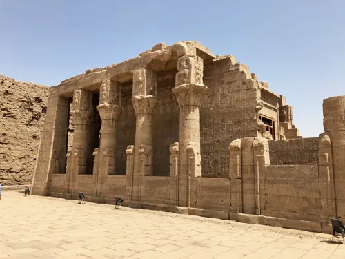
Temple of Edfu
Monument and historic site
Ancient Egyptian temple, located on the west bank of the Nile in Edfu, Upper Egypt


Parks, trails and playgrounds3


Restaurants and cafes9


Where to stay4
Churches and places of worship2
Shopping1
Schools, colleges and libraries4
Healthcare18
Map of Edfu
47 places. The map loads OpenStreetMap tiles when you open it.
Getting there and nearby towns
Luxor International Airport (LXR) is the nearest airport with scheduled flights listed in OpenStreetMap, 79 km away.
- Ar Radīsīyah Qiblī 8 km south, about 8 min by car
- Al Başalīyah Baḩrī 25 km northwest, about 25 min by car
- As Sibā‘īyah 31 km northwest, about 31 min by car
- Esna 48 km northwest, about 48 min by car
- Kom Ombo 56 km south, about 56 min by car
- Darāw 64 km south, about 1 h by car
- Ţūd 76 km northwest, about 1 h 15 min by car
- Armant 79 km northwest, about 1 h 15 min by car
- Al Bayāḑīyah 80 km north, about 1 h 15 min by car
- Luxor 83 km north, about 1 h 30 min by car
Drive times are estimates from straight-line distance, not routes.
Local news
Headlines from INDB.
Reviews, tips and questions
Loading what members have shared...
Sources and licences
- GeoNames (CC BY 4.0): population, coordinates, regions and time zone
- OpenStreetMap contributors (ODbL 1.0): places, airports, map data
- Openverse (see each image): photos
- Wikidata (CC0 1.0): elevation, founding date, time zone, website, landmarks and historic places
- Wikimedia Commons (see each image): photos
- Wikipedia (CC BY-SA 4.0): overview and history text
Photo credits
- Edfu 16, Olaf Tausch, CC BY 3.0
- Edfu Straße 08, Olaf Tausch, CC BY 3.0
- Edfu 43, Olaf Tausch, CC BY 3.0
- Edfu Straße 09, Olaf Tausch, CC BY 3.0
- Edfu 44, Olaf Tausch, CC BY 3.0
- Edfu Straße 07, Olaf Tausch, CC BY 3.0
- Edfu Straße 06, Olaf Tausch, CC BY 3.0
- Edfu Straße 10, Olaf Tausch, CC BY 3.0
- Edfu 42, Olaf Tausch, CC BY 3.0
- Edfu Straße 05, Olaf Tausch, CC BY 3.0
- Edfu Straße 04, Olaf Tausch, CC BY 3.0
- Edfu 37, Olaf Tausch, CC BY 3.0
- Edfu 36, Olaf Tausch, CC BY 3.0
- Edfu Straße 03, Olaf Tausch, CC BY 3.0
- Edfu 45, Olaf Tausch, CC BY 3.0
- Edfu 41, Olaf Tausch, CC BY 3.0
- Edfu Temple 埃得福神廟 - panoramio, lienyuan lee, CC BY 3.0
- Edfu 40, Olaf Tausch, CC BY 3.0
- Edfu 38, Olaf Tausch, CC BY 3.0
- El Markez, Edfu, AG, EGY (48022435312), Warren LeMay from Cullowhee, NC, United States, CC0
- El Markez, Edfu, AG, EGY (48022328141), Warren LeMay from Cullowhee, NC, United States, CC0
- El Markez, Edfu, AG, EGY (48022354378), Warren LeMay from Cullowhee, NC, United States, CC0
- Edfu Public Hospital, Edfu, AG, EGY (48022351663), Warren LeMay from Cullowhee, NC, United States, CC0
- Corniche, Edfu, AG, EGY (48022349818), Warren LeMay from Cullowhee, NC, United States, CC0
- Hasan Kassim, Edfu, AG, EGY (48022355968), Warren LeMay from Cullowhee, NC, United States, CC0
- Corniche, Edfu, AG, EGY (48022350123), Warren LeMay from Cullowhee, NC, United States, CC0
- Hasan Kassim, Edfu, AG, EGY (48022331266), Warren LeMay from Cullowhee, NC, United States, CC0
- El Markez, Edfu, AG, EGY (48022358713), Warren LeMay from Cullowhee, NC, United States, CC0
- El Markez, Edfu, AG, EGY (48022433547), Warren LeMay from Cullowhee, NC, United States, CC0
- El Markez, Edfu, AG, EGY (48022353528), Warren LeMay from Cullowhee, NC, United States, CC0
- Al Mabad, Edfu, AG, EGY (48022439132), Warren LeMay from Cullowhee, NC, United States, CC0
- Edfu Public Hospital, Edfu, AG, EGY (48022351303), Warren LeMay from Cullowhee, NC, United States, CC0
- Mosque, El Markez, Edfu, AG, EGY (48022328611), Warren LeMay from Cullowhee, NC, United States, CC0
- El Markez, Edfu, AG, EGY (48022435007), Warren LeMay from Cullowhee, NC, United States, CC0
- Hasan Kassim, Edfu, AG, EGY (48022437997), Warren LeMay from Cullowhee, NC, United States, CC0
- El Markez, Edfu, AG, EGY (48022439972), Warren LeMay from Cullowhee, NC, United States, CC0
- Al Mabad, Edfu, AG, EGY (48022438817), Warren LeMay from Cullowhee, NC, United States, CC0
- Al Mabad, Edfu, AG, EGY (48022357283), Warren LeMay from Cullowhee, NC, United States, CC0
- El Markez, Edfu, AG, EGY (48022330016), Warren LeMay from Cullowhee, NC, United States, CC0
- Temple of Edfu 02, Ad Meskens, CC BY-SA 3.0
- Birth House, Temple of Horus at Edfu, Edfu, AG, EGY, w_lemay, CC0 1.0


Page built November 7, 2026. Spotted a mistake? Tell us or suggest a place.