


Ellenville, New York
Ellenville is a village of 4,211 people in Ulster County, New York, founded in 1805.
Why visit Ellenville
Townapedia lists 14 museums and landmarks, 8 parks and trails, 6 places to eat, 2 places to stay and 15 attractions in and around town.
Highlights include Verkeerder Kill Falls, Sam's Point Preserve, Chetolah and Cragsmoor Historic District.
July is the warmest month, with average highs of 83°F; January lows average 19°F, and about 59 inches of snow fall in a normal year.
Weather in Ellenville
Forecast from the National Weather Service. Full forecast
About Ellenville
Ellenville is a village within the town of Wawarsing, Ulster County, New York, United States. Its population was 4,167 at the 2020 census.
From the Wikipedia article Ellenville, New York (this version), under CC BY-SA 4.0.
Things to do15

Verkeerder Kill Falls
Waterfall · 2.2 mi
Waterfall in Ulster County, New York, United States

Sam's Point Preserve
Monument and historic site · 2.5 mi
Nature preserve in Ulster County, New York, US



3 more on the map.
Museums and landmarks14

Chetolah
Monument and historic site · National Register of Historic Places · 3.1 mi
Historic house in New York, United States

Cragsmoor Historic District
Monument and historic site · National Register of Historic Places · 2.5 mi
Historic district in New York, United States

Ellenville Downtown Historic District
Monument and historic site · National Register of Historic Places · 1.8 mi
Historic district in Ellenville, New York

Hoornbeek Store Complex
Monument and historic site · National Register of Historic Places · 2.6 mi
Historic buildings in Napanoch, New York, United States

O & W Railroad Station at Port Ben
Monument and historic site · National Register of Historic Places · 3.1 mi
U.S. historic train station

Ontario and Western Railroad Passenger Station
Monument and historic site · National Register of Historic Places · 2.4 mi
Railway station near Napanoch, New York, U.S.
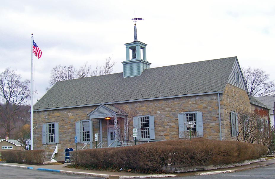


United States Post Office
Monument and historic site · National Register of Historic Places · 1.8 mi
Government building in Ellenville, New York


2 more on the map.
Parks, trails and playgrounds8



Restaurants and cafes6

China House
Restaurant · 2.0 mi
Chinese food
102 Shoprite Blvd
Fr, Sa 11:00-22:30; Su 12:00-22:00; Mo-Th 11:00-22:00
Il Paradiso Pizza and Restaurant
Restaurant · 2.0 mi
Pizza place
110 Shoprite Blvd
Tu-Th, Sa, Su 11:00-20:00; Mo, Fr 11:00-21:00



History
The area was originally called "Socconessing" by the first inhabitants, the Esopus Munsee of the Lenape. Socconessing means "a muddy place where the water comes out", referencing the Sandburg Creek. The Esopus lived in this area for thousands of years before being pushed out by the early pioneers.
The first building erected in what is now the center of the village was built around 1798 by Alpheus Fairchild, who moved west from Connecticut. However, in what is now the easternmost part of the village, the Bodley homestead most likely stood well before the Revolution, as did portions of the Bevier and Sax farms. It was named "Fairchild City" or just "The City" after Alpheus Fairchild, who bought most of today's village in 1798 from John A. DeWitt; Fairchild had a dwelling erected on part of the site where the George and John R. Hunt Memorial Building stands today. Nathan and Maria Hoornbeek bought the dwelling and enlarged it, converting it into an inn. The Hoornbeek Tavern was a gathering place for the citizens, and many important decisions about the community were made at meetings held there. Indeed, the decision to change the name of the community to "Ellenville" was proposed at the Hoornbeek Tavern. Village leaders, unable to agree upon a new name, were persuaded by Ellen Snyder, Maria Hoornbeek's sister, to name the village after her.
From the History section of Ellenville, New York on Wikipedia, under CC BY-SA 4.0.
Where to stay2
Churches and places of worship9
Christ Evangelical Lutheran Church
Church · Lutheran · 1.7 mi
105 Center Street, Ellenville
Christ Lutheran Church
Church · National Register of Historic Places · 1.7 mi
St Mark's United Methodist Church
Church · Methodist · 2.6 mi
68 Clinton Street, Napanoch
Congregation Anshe Tzaydik
Place of worship · 1.7 mi
184 Canal Street, Ellenville
Shopping4
Gas and EV charging1
Schools, colleges and libraries7
Healthcare1
Map of Ellenville
67 places. The map loads OpenStreetMap tiles when you open it.
Climate by month
Monthly table
| Month | High | Low | Rain | Snow |
|---|---|---|---|---|
| Jan | 34°F | 19°F | 3.8 in | 14.6 in |
| Feb | 37°F | 20°F | 3.2 in | 14.6 in |
| Mar | 46°F | 28°F | 4.3 in | 12.4 in |
| Apr | 60°F | 39°F | 4.0 in | 1.8 in |
| May | 70°F | 50°F | 4.0 in | 0.0 in |
| Jun | 78°F | 59°F | 4.8 in | 0.0 in |
| Jul | 83°F | 64°F | 4.7 in | 0.0 in |
| Aug | 80°F | 62°F | 4.8 in | 0.0 in |
| Sep | 72°F | 56°F | 5.2 in | 0.0 in |
| Oct | 61°F | 45°F | 5.2 in | 0.1 in |
| Nov | 49°F | 35°F | 3.8 in | 2.8 in |
| Dec | 38°F | 26°F | 4.8 in | 12.9 in |
U.S. Climate Normals 1991-2020 for Mohonk Lake Hcn (12 mi away), NOAA NCEI.
People and cost of living
American Community Survey 5-year estimates, 2020-2024, U.S. Census Bureau. Estimates have margins of error, larger for small towns.
Disaster history
Ulster County has had 27 federal disaster declarations since 2000, most often for severe storms.
- 2021-09-05: Remnants Of Hurricane Ida (Hurricane)
- 2021-09-02: Remnants Of Hurricane Ida (Hurricane)
- 2021-08-22: Hurricane Henri (Hurricane)
- 2020-03-20: Covid-19 Pandemic (Biological)
- 2020-03-13: Covid-19 (Biological)
- 2017-07-12: Severe Winter Storm And Snowstorm (Snowstorm)
OpenFEMA disaster declarations summaries.
Getting there and nearby towns
Orange County Airport (MGJ) is the nearest airport with scheduled flights listed in OpenStreetMap, 14 miles away.
- Walker Valley 4 mi south, about 7 min by car
- Kerhonkson 7 mi northeast, about 11 min by car
- Pine Bush 7 mi southeast, about 12 min by car
- Wurtsboro 11 mi southwest, about 18 min by car
- Gardiner 11 mi east, about 18 min by car
- Wallkill 12 mi southeast, about 20 min by car
- Fallsburg 13 mi west, about 21 min by car
- South Fallsburg 14 mi west, about 22 min by car
- Stone Ridge 15 mi northeast, about 23 min by car
- Scotchtown 16 mi south, about 25 min by car
Drive times are estimates from straight-line distance, not routes.
Local news
Headlines from INDB, the NEMICO news database.
Reviews, tips and questions
Loading what members have shared...
Sources and licences
- NCES EDGE (Public domain): public schools
- NOAA NCEI U.S. Climate Normals 1991-2020 (Public domain): climate by month
- OpenFEMA (Public domain): disaster declarations
- OpenStreetMap contributors (ODbL 1.0): places, airports, map data
- U.S. Census Bureau (Public domain): population, income, housing, education, commute
- Wikidata (CC0 1.0): elevation, founding date, time zone, website, landmarks and historic places
- Wikimedia Commons (see each image): photos
- Wikipedia (CC BY-SA 4.0): overview and history text
Photo credits
- Downtown Ellenville, NY, Daniel Case, CC BY-SA 3.0
- GlassworksEllenville, HighAtop94, CC BY-SA 4.0
- NY 52 wb northern leg in Ellenville (1), June 2026, Mr. Matté (if there is an issue with this image, contact me using this image's Commons talk page , my Commons user talk page , or my English Wikipedia user talk page ; I'll know about it a lot faster), CC BY-SA 4.0
- Ellenville, NY United Methodist Church, June 2026, Mr. Matté (if there is an issue with this image, contact me using this image's Commons talk page , my Commons user talk page , or my English Wikipedia user talk page ; I'll know about it a lot faster), CC BY-SA 4.0
- Ellenville, NY Government Center, June 2026, Mr. Matté (if there is an issue with this image, contact me using this image's Commons talk page , my Commons user talk page , or my English Wikipedia user talk page ; I'll know about it a lot faster), CC BY-SA 4.0
- St. Mary's and St. Andrew's Church, Ellenville, NY, June 2026, Mr. Matté (if there is an issue with this image, contact me using this image's Commons talk page , my Commons user talk page , or my English Wikipedia user talk page ; I'll know about it a lot faster), CC BY-SA 4.0
- US 209 nb entering Ellenville, NY, June 2026, Mr. Matté (if there is an issue with this image, contact me using this image's Commons talk page , my Commons user talk page , or my English Wikipedia user talk page ; I'll know about it a lot faster), CC BY-SA 4.0
- Trudy Resnick Farber Building, Ellenville, NY, June 2026, Mr. Matté (if there is an issue with this image, contact me using this image's Commons talk page , my Commons user talk page , or my English Wikipedia user talk page ; I'll know about it a lot faster), CC BY-SA 4.0
- Terwilliger House Museum, Ellenville, NY, June 2026, Mr. Matté (if there is an issue with this image, contact me using this image's Commons talk page , my Commons user talk page , or my English Wikipedia user talk page ; I'll know about it a lot faster), CC BY-SA 4.0
- NY 52 wb northern leg in Ellenville (2), June 2026, Mr. Matté (if there is an issue with this image, contact me using this image's Commons talk page , my Commons user talk page , or my English Wikipedia user talk page ; I'll know about it a lot faster), CC BY-SA 4.0
- Ellenville, NY Public Library and Museum, June 2026, Mr. Matté (if there is an issue with this image, contact me using this image's Commons talk page , my Commons user talk page , or my English Wikipedia user talk page ; I'll know about it a lot faster), CC BY-SA 4.0
- Ellenville, NY Leurenkill Cemetery, June 2026, Mr. Matté (if there is an issue with this image, contact me using this image's Commons talk page , my Commons user talk page , or my English Wikipedia user talk page ; I'll know about it a lot faster), CC BY-SA 4.0
- O&W Railroad Station at Port Ben, NY, Daniel Case, CC BY-SA 3.0
- Cragsmoor, NY, library and historical museum, Daniel Case, CC BY-SA 3.0
- Hoornbeek Store, Daniel Case, CC BY-SA 3.0
- Old O & W Railroad Station at Port Ben, Daniel Case, CC BY-SA 3.0
- Ellenville Post Office, Original uploader was Daniel Case at en.wikipedia, CC BY-SA 3.0
- Christ Lutheran Church Dec 09, Doug Kerr from Upstate New York, CC BY-SA 2.0
- George Innes, Jr. Estate "Chetah" View from rear garden, Kingston Souvenir Co., Kingston, NY, Public domain
- Buildings on Canal Street, Ellenville, NY, Daniel Case, CC BY-SA 3.0
- Vkf, Ankafm87, CC BY-SA 3.0
- SamsPineBarrens1, Mfwills, CC BY-SA 3.0
- Indian Rock - panoramio, Copperhead7, CC BY 3.0
- Tuthillhouse at the Mill interior, Nick Kaye, CC BY-SA 3.0
- NY 52 wb northern leg past Center Street, June 2026, Mr. Matté (if there is an issue with this image, contact me using this image's Commons talk page , my Commons user talk page , or my English Wikipedia user talk page ; I'll know about it a lot faster), CC BY-SA 4.0
- Lake Maratanza Under The Summer Sun, Wes Kania, CC BY 3.0
- Rocks In Lake Maratanza, Wes Kania, CC BY 3.0
- South approach of Old Route 52 Old Plank Rd bridge, Fallout loo, CC BY-SA 4.0
- North approach of Old Route 52 Old Plank Rd bridge, Fallout loo, CC BY-SA 4.0
- Closer view of old bridge and Route 52 overpass, Fallout loo, CC BY-SA 4.0
- Old bridge and Route 52 overpass, Fallout loo, CC BY-SA 4.0
- Lake Maratanza - panoramio, Copperhead7, CC BY 3.0
- NY 52 wb northern leg at US 209, June 2026, Mr. Matté (if there is an issue with this image, contact me using this image's Commons talk page , my Commons user talk page , or my English Wikipedia user talk page ; I'll know about it a lot faster), CC BY-SA 4.0
- Black Butterfly Resting On A Purple Flower, Wes Kania, CC BY 3.0
- NY 52 eb southern leg at US 209, June 2026, Mr. Matté (if there is an issue with this image, contact me using this image's Commons talk page , my Commons user talk page , or my English Wikipedia user talk page ; I'll know about it a lot faster), CC BY-SA 4.0
- ISS065-E-208864 - View of Earth, Earth Science and Remote Sensing Unit , Lyndon B. Johnson Space Center, Public domain
- ISS047-E-73685 - View of Earth, Earth Science and Remote Sensing Unit , Lyndon B. Johnson Space Center, Public domain
- ISS050-E-51316 - View of Earth, Earth Science and Remote Sensing Unit , Lyndon B. Johnson Space Center, Public domain
- ISS065-E-208863 - View of Earth, Earth Science and Remote Sensing Unit , Lyndon B. Johnson Space Center, Public domain
- ISS067-E-118000 - View of Earth, Earth Science and Remote Sensing Unit , Lyndon B. Johnson Space Center, Public domain


Page built October 30, 2026. Spotted a mistake? Tell us or suggest a place.