


Euclid, Ohio
Euclid is a city of 48,823 people in Cuyahoga County, Ohio, founded in 1796.
Why visit Euclid
Townapedia lists 8 museums and landmarks, 64 parks and trails, 90 places to eat, 3 places to stay and 3 attractions in and around town.
Highlights include Euclid Beach Park, Atlas Cinemas Lakeshore 7, Albert W. Henn Mansion and Greenwood Farm.
July is the warmest month, with average highs of 81°F; January lows average 24°F.
Weather in Euclid
Forecast from the National Weather Service. Full forecast
About Euclid
Euclid is a city in Cuyahoga County, Ohio, United States. Located on the southern shore of Lake Erie, it is an inner ring suburb of Cleveland. The population was 49,692 at the 2020 census, making it the fourth largest city in Cuyahoga County.
From the Wikipedia article Euclid, Ohio (this version), under CC BY-SA 4.0.
Things to do3
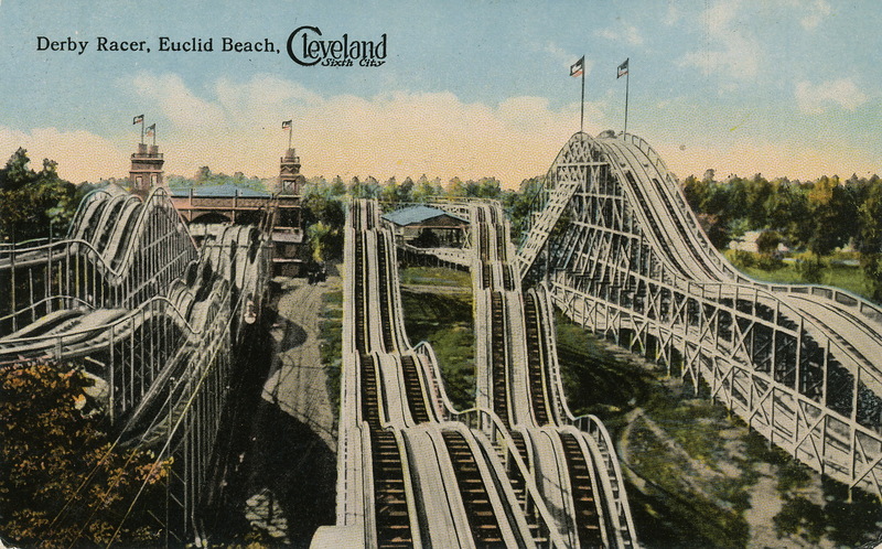
Euclid Beach Park
Monument and historic site · 2.7 mi
Amusement park in Cleveland, Ohio

Atlas Cinemas Lakeshore 7
Cinema and theater · 1.3 mi
22624 Lake Shore Boulevard, Euclid

Museums and landmarks8

Albert W. Henn Mansion
Monument and historic site · National Register of Historic Places · 1.6 mi
House in Euclid, Ohio

Greenwood Farm
Monument and historic site · National Register of Historic Places · 1.8 mi
Historic farm in Richmond Heights, Ohio, United States


Nela Park
Monument and historic site · National Register of Historic Places · 4.1 mi
Headquarters of GE Lighting in East Cleveland, Ohio


Parks, trails and playgrounds64





Humphrey Park Playground
Playground · 2.6 mi
Has 2 sets of swings. One for the babies and another for people who are about 4+. Has a slide and monkey bars that connect 2 playgrounds

52 more on the map.
Restaurants and cafes90


Petti's Pizza Ristorante
Restaurant · Pizza · 2.5 mi
29303 Euclid Avenue, Wickliffe
Su-Mo off; Tu-Sa 11:00-20:00
Rotasu Hibachi
Restaurant · Japanese · 2.6 mi
16122 Lake Shore Boulevard, Cleveland
Su 12:30-20:30; Mo-Th 11:00-20:30; Fr-Sa 11:00-21:30
Vittorio's
Restaurant · Italian · 2.9 mi
29664 Euclid Avenue, Wickliffe
Su 10:00-19:00; Mo-Tu off; We-Th 15:00-20:00; Fr-Sa 15:00-21:00

Lakeshore Coffee House
Cafe · Coffee Shop · 1.2 mi
22032 Lake Shore Boulevard, Euclid
Mo 06:00-18:00; Tu-Fr 06:00-21:00; Sa-Su 06:00-18:00
Charter House Grille
Bar and pub · 1.7 mi
991 East 185th Street, Cleveland
Mo-Th 12:00-22:00; Fr 12:00-21:00; Sa 13:00-23:00; Su off
Fresh Catch Seafood
Restaurant · Seafood · 1.6 mi
564 East 185th Street, Cleveland
11:00-22:30
Muncheez
Restaurant · 0.9 mi
24676 Euclid Avenue, Euclid
Su 13:00-21:00; Mo-Th 11:00-22:00; Fr-Sa 11:00-24:00
Ritual Juicery
Cafe · Juice · 3.0 mi
15619 Waterloo Road, Cleveland
Mo-Fr 09:30-17:00; Sa,Su 10:00-14:00
78 more on the map.
History
The City of Euclid was originally a part of Euclid Township, first mapped in 1796 and named for Euclid of Alexandria, the ancient Greek mathematician. The first sparse settlement in the township began in 1798, with major settlement beginning in the spring of 1804. The first settlers in what is now the City of Euclid were Joseph and Chloe Burke, David and Mary Dille and William and Jamima Coleman, and their children. Following the Civil War the lake plain of Euclid Township was known for numerous excellent vineyards. Euclid Village incorporated out of the northeast portion of the township in 1903. It developed as an industrial center in the early 20th century, and became a city in 1930.
Euclid is the city where Charles F. Brush created the Arc Lamp in 1876. The cordless telephone was invented in Euclid by George Sweigert in 1969.
Euclid is the site of the 1926 U.S. Supreme Court case Village of Euclid v. Ambler Realty Co. The case opened the doors for municipalities across the United States to establish zoning ordinances.
In June 2011, Lincoln Electric installed a 2.5 Megawatt wind turbine. At 443 feet, it is the largest in Ohio and one of the largest in North America
From the History section of Euclid, Ohio on Wikipedia, under CC BY-SA 4.0.
Where to stay3
Econo Lodge Wickliffe - Cleveland East
Motel and hotel · 1.8 mi
28611 Euclid Avenue, Wickliffe
Churches and places of worship35
First Church of Christ in Euclid
Church · National Register of Historic Places · 4.1 mi
St. Paul's Episcopal Church of East Cleveland
Church · National Register of Historic Places · 4.4 mi
Bethlehem Community Church
Church · Lutheran · 1.0 mi
24496 Euclid Avenue, Euclid
Celebration United Methodist Church
Church · Methodist · 1.3 mi
771 East 260th Street, Euclid
Imani United Church Of Christ
Church · Church Of Christ · 0.4 mi
832 East 222nd Street, Euclid
Saint John of the Cross Church
Church · Catholic · 1.2 mi
140 Richmond Road, Euclid
Shore Haven Lutheran Church
Church · Lutheran · 1.1 mi
280 East 222nd Street, Euclid
Shopping18
Gas and EV charging16
Schools, colleges and libraries65
Memorial-Nottingham Branch
Library · 2.3 mi
17109 Lake Shore Boulevard, Cleveland
Ohio Library for the Blind & Print Disabled
Library · 2.3 mi
17121 Lake Shore Boulevard, Cleveland
Healthcare12
University Hospitals Richmond Medical Center
Clinic and pharmacy · 1.8 mi
27100 Chardon Road, Cleveland
University Hospitals Euclid Health Center
Clinic and pharmacy · 1.6 mi
18599 Lake Shore Boulevard, Euclid
Map of Euclid
250 places. The map loads OpenStreetMap tiles when you open it.
Climate by month
Monthly table
| Month | High | Low | Rain |
|---|---|---|---|
| Jan | 35°F | 24°F | 1.8 in |
| Feb | 37°F | 24°F | 1.5 in |
| Mar | 45°F | 31°F | 2.4 in |
| Apr | 57°F | 41°F | 3.1 in |
| May | 68°F | 53°F | 3.5 in |
| Jun | 77°F | 63°F | 2.8 in |
| Jul | 81°F | 68°F | 3.7 in |
| Aug | 80°F | 67°F | 3.5 in |
| Sep | 74°F | 60°F | 2.9 in |
| Oct | 62°F | 49°F | 3.2 in |
| Nov | 50°F | 38°F | 2.9 in |
| Dec | 40°F | 30°F | 2.0 in |
U.S. Climate Normals 1991-2020 for Cleveland Burke Ap (10 mi away), NOAA NCEI.
People and cost of living
American Community Survey 5-year estimates, 2020-2024, U.S. Census Bureau. Estimates have margins of error, larger for small towns.
Disaster history
Cuyahoga County has had 11 federal disaster declarations since 2000, most often for severe storms.
- 2020-03-31: Covid-19 Pandemic (Biological)
- 2020-03-13: Covid-19 (Biological)
- 2013-01-03: Severe Storms And Flooding Due To The Remnants Of Hurricane Sandy (Hurricane)
- 2012-06-30: Severe Storms (Severe Storm)
- 2006-07-02: Severe Storms, Tornadoes, Straight Line Winds, And Flooding (Severe Storm)
- 2005-09-13: Hurricane Katrina Evacuation (Hurricane)
OpenFEMA disaster declarations summaries.
Getting there and nearby towns
Cuyahoga County Airport (CGF) is the nearest airport with scheduled flights listed in OpenStreetMap, 2 miles away.
- Richmond Heights 2 mi south, about 4 min by car
- Wickliffe 3 mi east, about 5 min by car
- Willowick 4 mi northeast, about 6 min by car
- South Euclid 5 mi south, about 8 min by car
- East Cleveland 5 mi southwest, about 8 min by car
- Lyndhurst 5 mi south, about 9 min by car
- Cleveland Heights 6 mi south, about 10 min by car
- Mayfield Heights 6 mi southeast, about 10 min by car
- Willoughby 7 mi northeast, about 11 min by car
- Eastlake 7 mi northeast, about 10 min by car
Drive times are estimates from straight-line distance, not routes.
Local news
Headlines from INDB, the NEMICO news database.
Reviews, tips and questions
Loading what members have shared...
Sources and licences
- NCES EDGE (Public domain): public schools
- NOAA NCEI U.S. Climate Normals 1991-2020 (Public domain): climate by month
- OpenFEMA (Public domain): disaster declarations
- OpenStreetMap contributors (ODbL 1.0): places, airports, map data
- U.S. Census Bureau (Public domain): population, income, housing, education, commute
- Wikidata (CC0 1.0): elevation, founding date, time zone, website, landmarks and historic places
- Wikimedia Commons (see each image): photos
- Wikipedia (CC BY-SA 4.0): overview and history text
Photo credits
- Euclid (Ohio) - Old City Hall, stu_spivack, CC BY-SA 2.0
- Albert W. Henn Mansion - Euclid, Ohio, NorthCoastReader, CC BY-SA 3.0
- Empowerment Church, East Cleveland, Nyttend, Public domain
- The main house at Greenwood Farm, RHOhio, CC BY-SA 3.0
- P1010768 - First United Presbyterian Church of East Cleveland, Ponceesponce, CC BY-SA 3.0
- Nela Park Building 307, Rpabst at en.wikipedia, Public domain
- Euclidbeach, Braun Post Card Co., Cleveland, Ohio. Ryecatcher773 at en.wikipedia, Public domain
Page built October 30, 2026. Spotted a mistake? Tell us or suggest a place.