


Richmond Heights, Ohio
Richmond Heights is a city of 10,626 people in Cuyahoga County, Ohio, founded in 1917.
Why visit Richmond Heights
Townapedia lists 9 museums and landmarks, 22 parks and trails, 28 places to eat and 1 attraction in and around town.
Highlights include Euclid Beach Park, Albert W. Henn Mansion, Forest Hill and Euclid Creek Reservation.
July is the warmest month, with average highs of 81°F; January lows average 24°F.
Weather in Richmond Heights
Forecast from the National Weather Service. Full forecast
About Richmond Heights
Richmond Heights is a city in Cuyahoga County, Ohio, United States. The population was 10,801 at the 2020 census. A suburb of Cleveland, it is part of the Cleveland metropolitan area.
From the Wikipedia article Richmond Heights, Ohio (this version), under CC BY-SA 4.0.
Things to do1
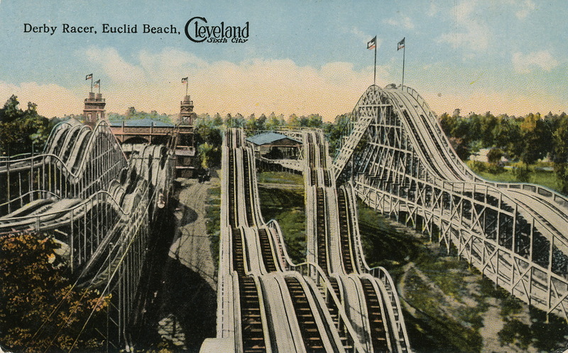
Euclid Beach Park
Monument and historic site · 3.5 mi
Amusement park in Cleveland, Ohio
Museums and landmarks9

Albert W. Henn Mansion
Monument and historic site · National Register of Historic Places · 3.9 mi
House in Euclid, Ohio

Forest Hill
Monument and historic site · National Register of Historic Places · 3.9 mi
Historic neighborhood spanning parts of Cleveland Heights and East Cleveland, Ohio, United States

Greenwood Farm
Monument and historic site · National Register of Historic Places · 1.1 mi
Historic farm in Richmond Heights, Ohio, United States

Nela Park
Monument and historic site · National Register of Historic Places · 3.1 mi
Headquarters of GE Lighting in East Cleveland, Ohio

Notre Dame College
Monument and historic site · National Register of Historic Places · 3.7 mi
Catholic, coeducational, liberal arts college in South Euclid, Ohio, U.S.

Parks, trails and playgrounds22






10 more on the map.
Restaurants and cafes28

Pizza Hut
Restaurant · Pizza · 1.7 mi
5140 Wilson Mills Road, Richmond Heights
Mo-Th 15:00-22:00; Fr-Su 10:30-22:00

Sweet Surprises
Bakery · 1.5 mi
732 Richmond Road
Mo-We,Fr 10:00-18:00; Th 10:00-20:00; Sa 10:00-16:00
Muncheez
Restaurant · 1.4 mi
24676 Euclid Avenue, Euclid
Su 13:00-21:00; Mo-Th 11:00-22:00; Fr-Sa 11:00-24:00

16 more on the map.
History
Originally a part of Euclid Township, Richmond Heights was founded as the Village of Claribel in 1917, but was later renamed as Richmond Heights in 1918.
From the History section of Richmond Heights, Ohio on Wikipedia, under CC BY-SA 4.0.
Churches and places of worship14
First Church of Christ in Euclid
Church · National Register of Historic Places · 3.3 mi
St. Paul's Episcopal Church of East Cleveland
Church · National Register of Historic Places · 3.5 mi
Bethlehem Community Church
Church · Lutheran · 1.3 mi
24496 Euclid Avenue, Euclid
Saint Gregory of Narek
Church · Armenian Apostolic · 1.3 mi
678 Richmond Road, Richmond Heights
Saint John of the Cross Church
Church · Catholic · 1.6 mi
140 Richmond Road, Euclid
Temple of Praise Seventh-Day Adventist Church
Church · Seventh Day Adventist · 2.0 mi
1985 Green Road, Cleveland
Shopping8
Gas and EV charging8
Schools, colleges and libraries51
Canterbury Elementary School
School · 5.3 mi
2530 Canterbury Rd, Cleveland Heights
Healthcare4
University Hospitals Richmond Medical Center
Clinic and pharmacy · 1.7 mi
27100 Chardon Road, Cleveland
Map of Richmond Heights
145 places. The map loads OpenStreetMap tiles when you open it.
Climate by month
Monthly table
| Month | High | Low | Rain |
|---|---|---|---|
| Jan | 35°F | 24°F | 1.8 in |
| Feb | 37°F | 24°F | 1.5 in |
| Mar | 45°F | 31°F | 2.4 in |
| Apr | 57°F | 41°F | 3.1 in |
| May | 68°F | 53°F | 3.5 in |
| Jun | 77°F | 63°F | 2.8 in |
| Jul | 81°F | 68°F | 3.7 in |
| Aug | 80°F | 67°F | 3.5 in |
| Sep | 74°F | 60°F | 2.9 in |
| Oct | 62°F | 49°F | 3.2 in |
| Nov | 50°F | 38°F | 2.9 in |
| Dec | 40°F | 30°F | 2.0 in |
U.S. Climate Normals 1991-2020 for Cleveland Burke Ap (10 mi away), NOAA NCEI.
People and cost of living
American Community Survey 5-year estimates, 2020-2024, U.S. Census Bureau. Estimates have margins of error, larger for small towns.
Disaster history
Cuyahoga County has had 11 federal disaster declarations since 2000, most often for severe storms.
- 2020-03-31: Covid-19 Pandemic (Biological)
- 2020-03-13: Covid-19 (Biological)
- 2013-01-03: Severe Storms And Flooding Due To The Remnants Of Hurricane Sandy (Hurricane)
- 2012-06-30: Severe Storms (Severe Storm)
- 2006-07-02: Severe Storms, Tornadoes, Straight Line Winds, And Flooding (Severe Storm)
- 2005-09-13: Hurricane Katrina Evacuation (Hurricane)
OpenFEMA disaster declarations summaries.
Getting there and nearby towns
Cuyahoga County Airport (CGF) is the nearest airport with scheduled flights listed in OpenStreetMap, 1 miles away.
- Euclid 2 mi north, about 4 min by car
- South Euclid 3 mi south, about 4 min by car
- Lyndhurst 3 mi south, about 5 min by car
- Wickliffe 4 mi northeast, about 6 min by car
- Mayfield Heights 4 mi southeast, about 7 min by car
- Cleveland Heights 4 mi southwest, about 7 min by car
- East Cleveland 4 mi southwest, about 7 min by car
- University Heights 5 mi south, about 8 min by car
- Willowick 5 mi north, about 9 min by car
- Beachwood 6 mi south, about 9 min by car
Drive times are estimates from straight-line distance, not routes.
Local news
Headlines from INDB, the NEMICO news database.
Reviews, tips and questions
Loading what members have shared...
Sources and licences
- NCES EDGE (Public domain): public schools
- NOAA NCEI U.S. Climate Normals 1991-2020 (Public domain): climate by month
- OpenFEMA (Public domain): disaster declarations
- OpenStreetMap contributors (ODbL 1.0): places, airports, map data
- U.S. Census Bureau (Public domain): population, income, housing, education, commute
- Wikidata (CC0 1.0): elevation, founding date, time zone, website, landmarks and historic places
- Wikimedia Commons (see each image): photos
- Wikipedia (CC BY-SA 4.0): overview and history text
Photo credits
- The main house at Greenwood Farm, RHOhio, CC BY-SA 3.0
- Flexjet Headquarters in Richmond Heights, Ohio - Oct 18, 2023 02, Cjrobe, CC BY-SA 4.0
- Flexjet Headquarters in Richmond Heights, Ohio - Oct 18, 2023 01, Cjrobe, CC BY-SA 4.0
- Albert W. Henn Mansion - Euclid, Ohio, NorthCoastReader, CC BY-SA 3.0
- Notre Dame College of Ohio admin building, Nyttend, Public domain
- Empowerment Church, East Cleveland, Nyttend, Public domain
- P1010768 - First United Presbyterian Church of East Cleveland, Ponceesponce, CC BY-SA 3.0
- Brewster east of Henley in Forest Hill, Nyttend, Public domain
- Nela Park Building 307, Rpabst at en.wikipedia, Public domain
- Euclidbeach, Braun Post Card Co., Cleveland, Ohio. Ryecatcher773 at en.wikipedia, Public domain
- Long Legs (8476134124), LASZLO ILYES from Cleveland, Ohio, USA, CC BY 2.0
- Along Came a Spider (8468160896), LASZLO ILYES from Cleveland, Ohio, USA, CC BY 2.0
- No Two Are Alike (5387343690), LASZLO ILYES from Cleveland, Ohio, USA, CC BY 2.0
- Cardinalis cardinalis -Cleveland, Ohio, USA -male-8, LASZLO ILYES from Cleveland, Ohio, USA, CC BY 2.0
- Passer domesticus (1), LASZLO ILYES from Cleveland, Ohio, USA, CC BY 2.0
- Cardinalis cardinalis -Cleveland, Ohio, USA -female-8, LASZLO ILYES from Cleveland, Ohio, USA, CC BY 2.0
- Electric water valve water effect, LASZLO ILYES from Cleveland, Ohio, USA, CC BY 2.0
- Splish Splash (4083880303), LASZLO ILYES from Cleveland, Ohio, USA, CC BY 2.0
- Shooting a Canon... (4057355817), LASZLO ILYES from Cleveland, Ohio, USA, CC BY 2.0
- It's a Small World (4039661466), LASZLO ILYES from Cleveland, Ohio, USA, CC BY 2.0
- Fore! (4084807630), LASZLO ILYES from Cleveland, Ohio, USA, CC BY 2.0
- H 2 Oh!? (4154722733), LASZLO ILYES from Cleveland, Ohio, USA, CC BY 2.0
- It's Abe... Honest (6763655377), LASZLO ILYES from Cleveland, Ohio, USA, CC BY 2.0
- Enduring Winter's Chill (4315839672), LASZLO ILYES from Cleveland, Ohio, USA, CC BY 2.0
- Squirrel in the snow ("Cold Nose"), LASZLO ILYES, CC BY 2.0
- Absinthe fountain 2, Dmitry Brant, CC BY-SA 4.0
- You Know... I Heard You Coming - Flickr - laszlo-photo, LASZLO ILYES from Cleveland, Ohio, USA, CC BY 2.0
- Euclid Creek rear quarry, Tim Evanson, CC BY-SA 2.0
- Richmond Town Square Penney's, Nicholas Eckhart, CC BY 2.0
- Pizza Margherita stu spivack, stu_spivack, CC BY-SA 2.0
- Salsiccia (3751025360), stu_spivack, CC BY-SA 2.0
- Pizza (3863688676), stu_spivack, CC BY-SA 2.0
- Lincoln Electric wind turbine, Jbarta, CC0
- Striking Gold (51647934523), Patrick Henry from Euclid, Ohio, United States, CC BY 2.0
- South Euclid Dog Park 2011-03-12 09.14.12, THD3, CC BY 3.0 us
- South Euclid Dog Park 2011-03-12 09.23.39, THD3, CC BY 3.0 us


Page built October 30, 2026. Spotted a mistake? Tell us or suggest a place.