


Fairview, New Jersey
Fairview is a borough of 15,099 people in Bergen County, New Jersey, founded in December 19, 1894.
Why visit Fairview
Townapedia lists 78 museums and landmarks, 13 parks and trails, 71 places to eat and 4 places to stay in and around town.
Highlights include 125th Street, 72nd Street, Verdi Square and 82nd Street Park.
July is the warmest month, with average highs of 85°F; January lows average 28°F, and about 30 inches of snow fall in a normal year.
Weather in Fairview
Forecast from the National Weather Service. Full forecast
About Fairview
Fairview is a borough located in Bergen County, in the U.S. state of New Jersey. According to the 2020 United States census, the borough's population was 15,025, an increase of 1,190 (+8.6%) from the 2010 census count of 13,835, which in turn reflected an increase of 580 (+4.4%) from the 13,255 counted in the 2000 census.
From the Wikipedia article Fairview, New Jersey (this version), under CC BY-SA 4.0.
Museums and landmarks78

125th Street
Monument and historic site · National Register of Historic Places · 2.4 mi
New York City IRT Broadway – Seventh Avenue Line subway station

72nd Street
Monument and historic site · National Register of Historic Places · 3.1 mi
New York City IRT Broadway – Seventh Avenue Line subway station
79th Street
Monument and historic site · National Register of Historic Places · 2.9 mi
New York City IRT Broadway – Seventh Avenue Line subway station
Alcoa Edgewater Works
Monument and historic site · National Register of Historic Places · 1.2 mi
Demolished factory in Edgewater, New Jersey
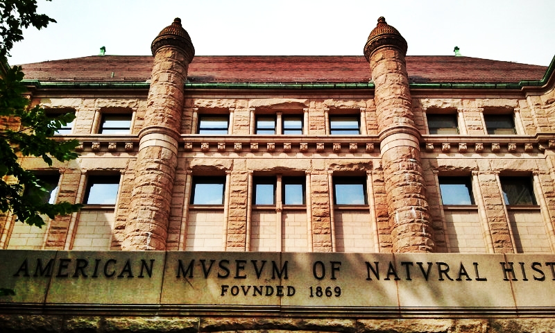
American Museum of Natural History
Monument and historic site · National Register of Historic Places · 3.2 mi
Natural history museum in Manhattan, New York

Apollo Theater
Monument and historic site · National Register of Historic Places · 2.9 mi
Theater and music venue in Harlem, New York City
Association Residence Nursing Home
Monument and historic site · National Register of Historic Places · 2.5 mi
Historic building in New York City
Beacon Theatre
Monument and historic site · National Register of Historic Places · 3.0 mi
Theater at 2124 Broadway, Manhattan

Bethune Gardens
Monument and historic site · National Register of Historic Places · 3.3 mi
Public housing development in Manhattan, New York

Binghamton
Monument and historic site · National Register of Historic Places · 1.4 mi
Ferry ship
Brooks and Hewitt Halls
Monument and historic site · National Register of Historic Places · 2.2 mi
Building complex in Manhattan, United States of America
Caspar Westervelt House
Monument and historic site · National Register of Historic Places · 3.4 mi
Building in New Jersey, United States
66 more on the map.
Parks, trails and playgrounds13

Verdi Square
Park · 3.1 mi
Park in Manhattan, New York City, United States of America

1 more on the map.
Restaurants and cafes71

Viva Margarita
Restaurant · Mexican · 1.1 mi
163 Old River Road, Edgewater
Mo-Th 12:00-23:00; Fr-Sa 12:00-00:00; Su 12:00-22:00
Brownstone Pancake Factory
Restaurant · Breakfast, Pancake, Sandwich · 1.5 mi
860 River Road, Edgewater
Mo-Th 08:00-15:00; Fr-Sa 08:00-20:00; Su 08:00-17:00
Frank's Pizza at Shadyside
Restaurant · Pizza, Italian · 1.0 mi
276 Old River Road, Edgewater
Tu-Sa 11:00-22:00; Su 12:00-21:00
Iichiya Sushi
Restaurant · Japanese · 1.3 mi
783 Palisade Avenue, Cliffside Park
Mo-Th 12:00-22:00; Fr-Sa 12:00-23:00; Su 13:00-22:00
Outback Steakhouse
Restaurant · American, Steak · 1.3 mi
539 River Road, Edgewater
Mo-Th 11:00-22:00; Fr,Sa 11:00-23:00; Su 11:00-21:30
Pa De Thai Restaurant
Restaurant · Thai · 1.0 mi
264 Old River Road, Edgewater
Mo-Th 11:30-22:00; Fr-Sa 12:00-22:30; Su 12:00-22:00
Pomodoro
Restaurant · Pizza · 1.3 mi
795 Abbott Boulevard, Fort Lee
Mo-Th 11:00-22:00; Fr,Sa 11:00-23:00; Su 12:00-22:00
Porto by Antonio
Restaurant · Pizza, Italian · 1.2 mi
8921 Old River Road, North Bergen
Mo-Th 12:00-22:00; Fr-Sa 12:00-23:00; Su 12:00-21:00
Rebecca's
Restaurant · Cuban · 1.1 mi
236 Old River Road, Edgewater
Tu-Th 17:00-22:00; Fr-Sa 17:00-23:00; Su 16:00-21:00
59 more on the map.
Where to stay4



Churches and places of worship22
Shopping20
Gas and EV charging13
Schools, colleges and libraries58
Bergen County Technical High School - Teterboro
School · 3.8 mi
504 Route 46 West, Teterboro
Healthcare5
Aspire Health Pharmacy
Clinic and pharmacy · 1.1 mi
673 Palisade Avenue, Cliffside Park
Map of Fairview
250 places. The map loads OpenStreetMap tiles when you open it.
Climate by month
Monthly table
| Month | High | Low | Rain | Snow |
|---|---|---|---|---|
| Jan | 40°F | 28°F | 3.6 in | 8.8 in |
| Feb | 42°F | 30°F | 3.2 in | 10.1 in |
| Mar | 50°F | 36°F | 4.3 in | 5.0 in |
| Apr | 62°F | 46°F | 4.1 in | 0.4 in |
| May | 71°F | 55°F | 4.0 in | 0.0 in |
| Jun | 80°F | 64°F | 4.5 in | 0.0 in |
| Jul | 85°F | 70°F | 4.6 in | 0.0 in |
| Aug | 83°F | 69°F | 4.6 in | 0.0 in |
| Sep | 76°F | 62°F | 4.3 in | 0.0 in |
| Oct | 64°F | 51°F | 4.4 in | 0.1 in |
| Nov | 54°F | 42°F | 3.6 in | 0.5 in |
| Dec | 44°F | 34°F | 4.4 in | 4.9 in |
U.S. Climate Normals 1991-2020 for New York Cntrl Pk Twr Hcn 72506 (3 mi away), NOAA NCEI.
People and cost of living
American Community Survey 5-year estimates, 2020-2024, U.S. Census Bureau. Estimates have margins of error, larger for small towns.
Disaster history
Bergen County has had 21 federal disaster declarations since 2000, most often for hurricanes.
- 2021-09-05: Remnants Of Hurricane Ida (Hurricane)
- 2021-09-02: Remnants Of Hurricane Ida (Hurricane)
- 2020-12-11: Tropical Storm Isaias (Hurricane)
- 2020-03-25: Covid-19 Pandemic (Biological)
- 2020-03-13: Covid-19 (Biological)
- 2018-06-08: Severe Winter Storm And Snowstorm (Severe Storm)
OpenFEMA disaster declarations summaries.
Getting there and nearby towns
Teterboro Airport (TEB) is the nearest airport with scheduled flights listed in OpenStreetMap, 4 miles away.
- East Rutherford 4 mi west, about 7 min by car
- Jersey City 8 mi southwest, about 13 min by car
- New York 11 mi south, about 18 min by car
- Paterson 11 mi northwest, about 17 min by car
- Newark 11 mi southwest, about 18 min by car
- Yonkers 11 mi northeast, about 18 min by car
- Elizabeth 15 mi southwest, about 24 min by car
- Florham Park 21 mi west, about 33 min by car
- Greenwich 24 mi northeast, about 39 min by car
- Fords 26 mi southwest, about 41 min by car
Drive times are estimates from straight-line distance, not routes.
Local news
Headlines from INDB, the NEMICO news database.
Reviews, tips and questions
Loading what members have shared...
Sources and licences
- NCES EDGE (Public domain): public schools
- NOAA NCEI U.S. Climate Normals 1991-2020 (Public domain): climate by month
- OpenFEMA (Public domain): disaster declarations
- OpenStreetMap contributors (ODbL 1.0): places, airports, map data
- U.S. Census Bureau (Public domain): population, income, housing, education, commute
- Wikidata (CC0 1.0): elevation, founding date, time zone, website, landmarks and historic places
- Wikimedia Commons (see each image): photos
- Wikipedia (CC BY-SA 4.0): overview and history text
Photo credits
- NorthernBranchROWFairview, Hudconja, CC BY-SA 3.0
- NJ Route 63 nb, Fairview, Jan. 2025, Mr. Matté (if there is an issue with this image, contact me using this image's Commons talk page , my Commons user talk page , or my English Wikipedia user talk page ; I'll know about it a lot faster), CC BY-SA 4.0
- 2018-07-22 13 17 42 View north along New Jersey State Route 63 and Bergen County Route 501 (Bergen Boulevard) between Morningside Avenue and Park Avenue in Fairview, Bergen County, New Jersey, Famartin, CC BY-SA 4.0
- 2018-07-22 13 05 59 View south along New Jersey State Route 63 and Bergen County Route 501 (Bergen Boulevard) between Kamena Street and Kennedy Drive in Fairview, Bergen County, New Jersey, Famartin, CC BY-SA 4.0
- 2018-07-22 10 30 24 View south along U.S. Route 1 and U.S. Route 9 (Broad Avenue) just south of Prospect Avenue in Fairview, Bergen County, New Jersey, Famartin, CC BY-SA 4.0
- 2018-07-22 13 20 58 View north along New Jersey State Route 63 and Bergen County Route 501 (Bergen Boulevard) at Fairview Terrace in Ridgefield, Bergen County, New Jersey, Famartin, CC BY-SA 4.0
- 2018-07-22 13 02 16 View south along New Jersey State Route 63 and Bergen County Route 501 (Bergen Boulevard) at Fairview Terrace in Ridgefield, Bergen County, New Jersey, Famartin, CC BY-SA 4.0
- 2018-07-22 10 33 42 View north along U.S. Route 1 and U.S. Route 9 (Broad Avenue) just south of Prospect Avenue in Fairview, Bergen County, New Jersey, Famartin, CC BY-SA 4.0
- Kamena Street wb, Fairview, NJ, Jan. 2025, Mr. Matté (if there is an issue with this image, contact me using this image's Commons talk page , my Commons user talk page , or my English Wikipedia user talk page ; I'll know about it a lot faster), CC BY-SA 4.0
- Fairview clock Anderson Av & Kennedy Dr jeh, Jim.henderson, CC BY-SA 4.0
- Lincoln Sch 140 Anderson Av Fairview NJ jeh, Jim.henderson, CC BY-SA 4.0
- 2018-07-22 13 10 48 View north along New Jersey State Route 63 and Bergen County Route 501 (Bergen Boulevard) at Hancock Place in Fairview, Bergen County, New Jersey, Famartin, CC BY-SA 4.0
- Ascension Greek Orthodox Church, Fairview, NJ, Jan. 2025, Mr. Matté (if there is an issue with this image, contact me using this image's Commons talk page , my Commons user talk page , or my English Wikipedia user talk page ; I'll know about it a lot faster), CC BY-SA 4.0
- 2018-07-22 13 08 43 View south along New Jersey State Route 63 and Bergen County Route 501 (Bergen Boulevard) at Sherman Place in Fairview, Bergen County, New Jersey, Famartin, CC BY-SA 4.0
- Bergenwood Avenue nb entering Fairview, NJ, Jan. 2025, Mr. Matté (if there is an issue with this image, contact me using this image's Commons talk page , my Commons user talk page , or my English Wikipedia user talk page ; I'll know about it a lot faster), CC BY-SA 4.0
- Fairview, NJ municipal complex, Jan. 2025, Mr. Matté (if there is an issue with this image, contact me using this image's Commons talk page , my Commons user talk page , or my English Wikipedia user talk page ; I'll know about it a lot faster), CC BY-SA 4.0
- Anderson Avenue nb, Fairview, NJ, Jan. 2025, Mr. Matté (if there is an issue with this image, contact me using this image's Commons talk page , my Commons user talk page , or my English Wikipedia user talk page ; I'll know about it a lot faster), CC BY-SA 4.0
- Fairview, NJ post office, Jan. 2025, Mr. Matté (if there is an issue with this image, contact me using this image's Commons talk page , my Commons user talk page , or my English Wikipedia user talk page ; I'll know about it a lot faster), CC BY-SA 4.0
- Harlem - Apollo Theater (48555309512), Ajay Suresh from New York, NY, USA, CC BY 2.0
- 1 West 72nd Street (The Dakota) by David Shankbone, David Shankbone, CC BY-SA 3.0
- Harlem Jul 2026 89, Epicgenius, CC BY-SA 4.0
- American Museum of Natural History 02, Gigi alt, CC BY-SA 3.0
- James Baldwin House, Jay Dobkin, CC BY-SA 4.0
- West End Collegiate Church 77 jeh, Jim.henderson, Public domain
- Isiah-house-nyc, Americasroof, CC BY-SA 3.0
- Binghamton Ferry, Hisland7, CC BY-SA 3.0
- North Presbyterian Church, 155th Street, Manhattan, Unknown photographer Unknown photographer, Public domain
- Hotel Theresa from east, Beyond My Ken, CC BY-SA 4.0
- 69th St Hudson RR bridge sinking jeh, Jim.henderson, CC0
- Duke-ellington, Dmadeo, CC BY-SA 3.0
- Old Broadway Synagogue sun jeh, Jim.henderson, CC0
- 40-50 W67 jeh, Jim.henderson, Public domain
- Mary McLeod Bethune Gardens NYCHA jeh, Jim.henderson, CC0
- Belnord 10th Av jeh, Jim.henderson, CC0
- WTM NewYorkDolls 045, This photo was taken by participant/team NewYorkDolls as part of the Commons:Wikipedia Takes Manhattan project on April 4, 2008. This file is licensed under the Creative Commons Attribution-Share..., CC BY-SA 3.0
- Master Apartments 1, niznoz, CC BY-SA 2.0
- Exempt Firehouse, Polk Street, West New York, NJ, Zeete, CC BY-SA 4.0
- 72nd Street IRT 9262, Gryffindor, CC BY-SA 3.0
- Harlem-firetower, Dmadeo, CC BY-SA 3.0
- The Dorilton 001, Gryffindor, Public domain


Page built October 30, 2026. Spotted a mistake? Tell us or suggest a place.